Report on Ambrym (Vanuatu) — May 2011
Bulletin of the Global Volcanism Network, vol. 36, no. 5 (May 2011)
Managing Editor: Richard Wunderman.
Ambrym (Vanuatu) Ongoing plumes, some bearing ash and to over 6 km altitude
Please cite this report as:
Global Volcanism Program, 2011. Report on Ambrym (Vanuatu) (Wunderman, R., ed.). Bulletin of the Global Volcanism Network, 36:5. Smithsonian Institution. https://doi.org/10.5479/si.GVP.BGVN201105-257040
Ambrym
Vanuatu
16.25°S, 168.12°E; summit elev. 1334 m
All times are local (unless otherwise noted)
In our last report on Ambrym (BGVN: 3411), we described the frequent thermal anomalies from the volcano's active lava lakes during October 2008-September 2009. Satellite imagery in 2009 and 2010 suggested ongoing visible plumes and thermal alerts consistent with active lava lakes. Several satellite images of Vanuatu appear below (figures 21-22).
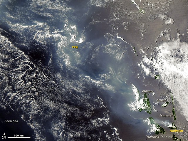 |
Figure 21. A hazy layer of vog (volcanic fog) overlies Malekula and a few other islands of the Vanuatu archipelago in this natural-color satellite image from 6 October 2009. The source of the vog is Ambrym, a volcano (and island of the same name) in the SE (lower right) corner of this scene. The haze extends over the Coral Sea several hundred kilometers to the NW. Ambrym emits SO2, the gas responsible for the formation of vog, intermittently. The Moderate Resolution Imaging Spectroradiometer (MODIS) aboard NASA's Aqua satellite acquired this natural-color image. NASA image by Jeff Schmaltz, MODIS Rapid Response, NASA Goddard Space Flight Center (the Rapid Response Team provides twice-daily images of this region). Caption by Robert Simmon. |
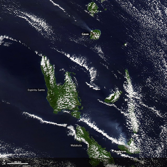 |
Figure 22. Diffuse plumes rise from Gaua volcano (top) and Ambrym volcano (bottom) in the Vanuatu archipelago. Both Gaua and Ambrym are located in the New Hebrides island arc, where the Pacific plate is subducting beneath the Australian plate. This natural-color image was acquired on 2 August 2010, by the Moderate Resolution Imaging Spectrometer (MODIS) aboard NASA's Terra satellite. NASA image by Jeff Schmaltz ; caption by Robert Simmon. Courtesy of NASA Earth Observatory. |
Based on observations by aircraft pilots, analyses of satellite imagery, and information from the Vanuatu Geohazards Observatory (VGO), the Wellington Volcanic Ash Advisory Center (VAAC) reported that on 8 and 10 August 2010 ash and steam plumes from Ambrym volcano rose to an altitude 6.1 km and drifted W and NW.
Ambrym is a major source of SO2 in the Vanuatu Republic. The VGO web site shows daily Vanuatu volcanic sulfur dioxide (SO2) fluxes through a partnership with GNS Science Institute (Taupo, New Zealand) using OMI satellite images.
Figure 23 shows a 22 May 2011 satellite image of Ambrym. Similar images were acquired by NASA satellites on 28 March 2011 and on 7 June 2011. On figure 23, a blue-tinged volcanic plume emissions extends from Ambrym to the W. The plume contains vog, a mix of gases and aerosols that is formed when SO2 and other volcanic gases react with sunlight, oxygen, and moisture.
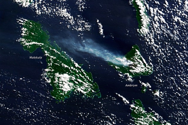 |
Figure 23. A natural-color image showing Ambrym and its W-blowing plume. The image was acquired by MODIS (the Moderate Resolution Imaging Spectroradiometer aboard the Terra satellite) on the morning of 22 May 2011. NASA image by Jeff Schmaltz, MODIS Rapid Response Team, NASA-GSFC. Courtesy of NASA Earth Observatory. |
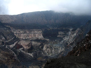
Geological Summary. Ambrym, a large basaltic volcano with a 12-km-wide caldera, is one of the most active volcanoes of the New Hebrides Arc. A thick, almost exclusively pyroclastic sequence, initially dacitic then basaltic, overlies lava flows of a pre-caldera shield volcano. The caldera was formed during a major Plinian eruption with dacitic pyroclastic flows about 1,900 years ago. Post-caldera eruptions, primarily from Marum and Benbow cones, have partially filled the caldera floor and produced lava flows that ponded on the floor or overflowed through gaps in the caldera rim. Post-caldera eruptions have also formed a series of scoria cones and maars along a fissure system oriented ENE-WSW. Eruptions have apparently occurred almost yearly during historical time from cones within the caldera or from flank vents. However, from 1850 to 1950, reporting was mostly limited to extra-caldera eruptions that would have affected local populations.
Information Contacts: Vanuatu Geohazards Observatory, Department of Geology, Mines and Water Resources of Vanuatu (URL: http://www.vmgd.gov.vu/vmgd/); NASA Earth Observatory (URL: http://earthobservatory.nasa.gov/); MODIS/MODVOLC Thermal Alerts System, Hawai'i Institute of Geophysics and Planetology (HIGP), School of Ocean and Earth Science and Technology (SOEST), Univ. of Hawai'i, 2525 Correa Road, Honolulu, HI 96822, USA (URL: http://modis.higp.hawaii.edu/); Wellington Volcanic Ash Advisory Centre (VAAC), Meteorological Service of New Zealand Ltd (MetService), PO Box 722, Wellington, New Zealand (URL: http://www.metservice.com/vaac/, URL: http://vaac.metservice.com/).