Report on Manam (Papua New Guinea) — June 2011

Bulletin of the Global Volcanism Network, vol. 36, no. 6 (June 2011)
Managing Editor: Richard Wunderman.
Manam (Papua New Guinea) Eruptions ongoing from August 2010 to January 2011
Please cite this report as:
Global Volcanism Program, 2011. Report on Manam (Papua New Guinea) (Wunderman, R., ed.). Bulletin of the Global Volcanism Network, 36:6. Smithsonian Institution. https://doi.org/10.5479/si.GVP.BGVN201106-251020
Manam
Papua New Guinea
4.08°S, 145.037°E; summit elev. 1807 m
All times are local (unless otherwise noted)
Manam eruptions continued, and from 13 November 2010 to 3 January 2011, the MODVOLC satellite-based system registered almost daily alerts. Fewer alerts continued into at least July 2011. This report also describes activity as provided by the Rabaul Volcanological Observatory (RVO) during 31 December 2010 to 11 January 2011, augmenting and extending our previous Bulletin reports (BGVN 35:02, 35:09, and 36:01-02). A map illustrating the edifice's remarkably symmetric form appears below (figure 28).
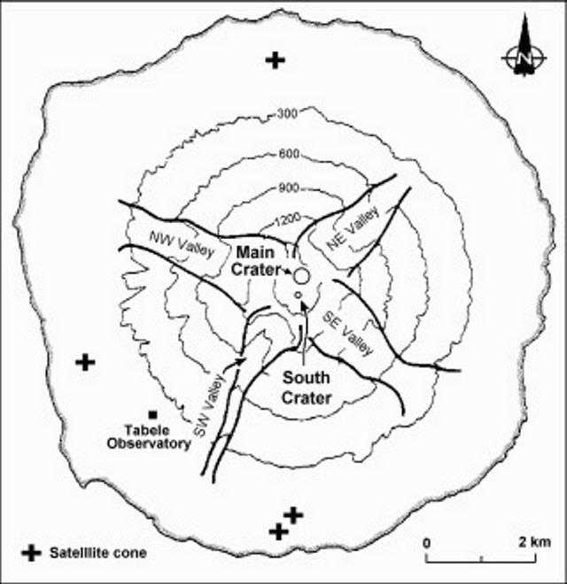 |
Figure 28. Map of the island of Manam showing the locations of the Main Crater and South Crater and the four radial "avalanche valleys" that channel pyroclastic flows from the summit. Plus symbols indicate locations of satellitic cones. Base map after Palfreyman and Cooke (1976). |
As a review, in BGVN 36:01-02 we noted a new episode of eruptive activity that began on 25 December 2010 and escalated on 30 December, culminating with several destructive pyroclastic flows.
On 31 December 2010, white vapor rose from the crater. Later that day, activity increased again. Gray ash plumes rose 200-300 m above the South Crater and also above the Main Crater. Low booming sounds were noted and incandescence from the crater was observed at night. During 1-4 January eruptive activity continued from South Crater and gray-to-black ash plumes rose above the summit crater. Incandescence emanated from the crater. During 3-4 January incandescent fragments were ejected onto the flanks and rolled down the SE valley. White vapor rose from the Main Crater.
On the website Malum Nalu viewed on 2 January 2011 Sir Peter Leslie Charles Barter (former Minister for Health, Papua New Guinean (PNG) government) reported that as the results of a series of eruptions on 25-30 December 2010, followed by larger eruptions, some panic occurred by people that had returned to Manam Island. At Dugalava, a spokesman for the people told the provincial disaster office that more than 1,000 people needed to be evacuated. Barter flew with former Madang Province Governor and current PNG Attorney General Sir Arnold Amet to Manam on 1 January 2011 for an aerial inspection. At that time there was evidence of lava flows in two valleys, but most of the villages were intact and the eruption had subsided.
RVO reported that during 5-6 January low roaring from Manam's South Crater was heard and weak but steady crater incandescence was observed at night. Diffuse blue vapor was emitted from South Crater on 6 January. During 6-8 January white vapor rose from Main Crater and incandescence from both craters was observed at night. Diffuse brown ash plumes occasionally rose from South Crater on 7 January. On 8 January the volcano Alert status was lowered from Level 3 to Level 2. During 8-9 January Main Crater emitted white vapor and South Crater produced occasional gray ash plumes that drifted to the SE part of the island. Emissions from Main Crater turned to gray on 10 January. White-to-blue vapor plumes rose from South Crater. Both craters were incandescent at night during 8-10 January.
On 11 January 2011, RVO reported that Southern Crater released weak volumes of white vapor, and a steady weak glow was visible at night. Main Crater had similar activity.
Satellite measurements. MODVOLC satellite thermal alerts vary significantly during July 2008-June 2011, with periods of up to months of quiet, and seven weeks of daily to near-daily interval of alerts near the end of 2010. During late July 2008 through mid-November 2010, the MODVOLC satellite thermal alerts system measured very infrequent thermal alerts of 1, 2, and, once, 3 pixels. During the periods of 29 July 2008-19 January 2009 and 4 October 2009-9 August 2010, no alerts were measured. However, during a period of ~7 weeks, 13 November 2010-3 January 2011, almost daily alerts were measured. Subsequently, only two additional, 1-pixel Terra satellite thermal alerts were measured through mid-June 2011; one on 10 January 2011 at 1255 UDT and one on 6 March 2011 at 1300 UDT. Thus, the period of nearly daily measured thermal alerts during the end of 2010 appears to be rather anomalous. Several periods of thermal alerts were measured 28-30 June and 14-19 July 2011, but not accompanied with field observations.
Reference. Palfreyman, W.D., and Cooke, R.J.S., 1976, Eruptive history of Manam volcano, Papua New Guinea in Johnson R.W. (ed.), Volcanism in Australasia, Elsevier, Amsterdam, p. 117-131.
Geological Summary. The 10-km-wide island of Manam, lying 13 km off the northern coast of mainland Papua New Guinea, is one of the country's most active volcanoes. Four large radial valleys extend from the unvegetated summit of the conical basaltic-andesitic stratovolcano to its lower flanks. These valleys channel lava flows and pyroclastic avalanches that have sometimes reached the coast. Five small satellitic centers are located near the island's shoreline on the northern, southern, and western sides. Two summit craters are present; both are active, although most observed eruptions have originated from the southern crater, concentrating eruptive products during much of the past century into the SE valley. Frequent eruptions, typically of mild-to-moderate scale, have been recorded since 1616. Occasional larger eruptions have produced pyroclastic flows and lava flows that reached flat-lying coastal areas and entered the sea, sometimes impacting populated areas.
Information Contacts: Rabaul Volcano Observatory (RVO), PO Box 386, Rabaul, Papua New Guinea; Malum Nalu (URL: http://malumnalu.blogspot.com/2011/01/volcano-erupts-on-manam-island.html); Hawai'i Institute of Geophysics and Planetology (HIGP) MODVOLC Thermal Alerts System, School of Ocean and Earth Science and Technology (SOEST), Univ. of Hawai'i, 2525 Correa Road, Honolulu, HI 96822, USA (URL: http://modis.higp.hawaii.edu/); Darwin Volcanic Ash Advisory Centre (VAAC) (URL: http://www.bom.gov.au/info/vaac/).