Report on Dieng Volcanic Complex (Indonesia) — June 2011
Bulletin of the Global Volcanism Network, vol. 36, no. 6 (June 2011)
Managing Editor: Richard Wunderman.
Dieng Volcanic Complex (Indonesia) Seismicity and dangerous gas emissions; 1,200 evacuate in May-June 2011
Please cite this report as:
Global Volcanism Program, 2011. Report on Dieng Volcanic Complex (Indonesia) (Wunderman, R., ed.). Bulletin of the Global Volcanism Network, 36:6. Smithsonian Institution. https://doi.org/10.5479/si.GVP.BGVN201106-263200
Dieng Volcanic Complex
Indonesia
7.2°S, 109.879°E; summit elev. 2565 m
All times are local (unless otherwise noted)
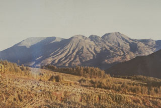
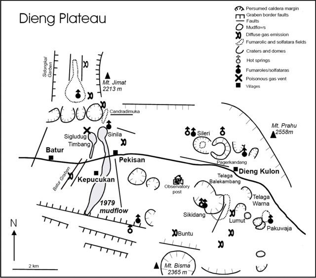
This report on Dieng volcanic complex (figure 2) notes both toxic gas emissions and episodes of high seismicity during 1 October 2009-July 2011. A late May 2011 visit, after increased gas emissions were noted the previous week, revealed dead birds and damaged vegetation at Timbang crater. Gas measurements at several sites confirmed the presence of hazardous gases; however, there were no human fatalities or injuries noted. According to news reports, 1,200 people were evacuated. Our previous report on Dieng discussed a phreatic eruption on 26 September 2009, preceded by a series of volcanic earthquakes (BGVN 34:08).
During January 2010, landslides took place near Dieng, followed by others at distance. One landslide crossed the highway between Dieng and Wonosobo (the regional capital, 18 km S of Dieng). The second landslide struck a village called Wonoaji, and according to a Jakarta Post article (by Suherdjoko, 21 January 2010), "Two people [there] have died and three are still missing, while five others were injured. . . ."
Although little was reported regarding Dieng during October 2009-2010, Relief Web posted a graphic describing heavy rains and regional flooding during February 2010 in the portion of Central Java hundreds of kilometers E of Dieng near Bandung. This episode triggered a landslide in Ciwidey village taking 17 lives.
The latest reported activity at Dieng began in mid-2011. According to the Center of Volcanology and Geological Hazard Mitigation (CVGHM), seismicity at Dieng increased during 18-22 May 2011. On 22 May, diffuse white plumes rose from the Timbang cone; plumes from the cone had not been previously observed. The next day carbon dioxide (CO2) emissions increased. On 23 May, CVGHM raised the Alert Level to 2 (on a scale of 1-4).
CVGHM reported that on 29 May 2011, gas plumes rose 50 m above Timbang cone. The gas plumes drifted S through the valley. Observers who visited the cone noted the previously mentioned damaged vegetation and dead birds. Seismicity and CO2 emissions remained elevated, thus prompting CVGHM to raise the Alert Level to 3.
During 4-5 June white plumes from Sileri crater rose 20-60 m and white plumes from Timbang rose only 2 m and drifted 300 m S. Seismicity and carbon dioxide remained high through 5 June
According to CVGHM, carbon-dioxide emissions from Timbang declined during 31 May-10 June, while seismicity decreased during 5-7 June and was not detected during 8-10 June. White plumes were not observed. On 10 June the Alert Level was lowered to 2.
Stated gas concentrations. In early June, low levels of hydrogen sulfide (H2S, 0.002-0.05% by volume) were recorded at Sikendang, Sikidang, Sibanteng, and Sileri craters. Carbon monoxide gas (CO) was only detected along the steam vents of Sikendang crater, at a concentration of 0.004% by volume. CO2 was measured at a concentration of 5.0% by volume. On 5 June, the CO2 from Timbang was at its highest level at, 1.54% by volume. The scientists added that weather patterns had brought low atmospheric pressure, which had enhanced gas escape at the vent.
John Seach presents modest-resolution photos from 2010 showing the Sikidang vent mentioned above, and Telega Warna crater lake (see Information Contacts).
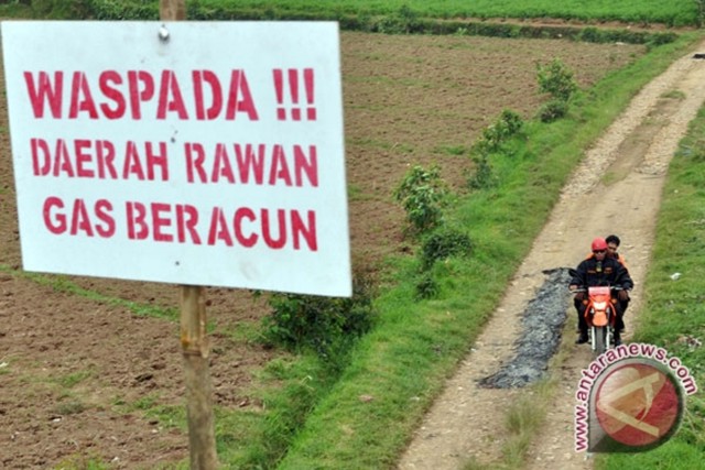
Figure 3 shows one approach to communicating gas-hazards warnings.
Dieng plateau. In the modern record, Dieng has a history of lethal gas emissions, phreatic explosions, and other hazards. The complex contains rocks ranging from andesite to rhyodacite, extrusives filling and sitting upon a large older (Pleistocene) caldera. It contains several stratovolcanoes, and many cones, craters, domes, and thermal features (see subsections below).
Van Bergen and others (2000) described the plateau and associated volcanic complex, portions of which follow.
"The Dieng Volcanic Complex in Central Java is situated on a highland plateau at about 2000 m above sea level, approximately 25 km N of the city of Wonosobo. It belongs to a series of Quaternary volcanoes, which includes the historically active Sumbing and Sundoro volcanoes. The plateau is a rich agricultural area for potatoes, cabbages, tomatoes and other vegetables. There are numerous surface manifestations of hydrothermal activity, including lakes, fumaroles/solfatara and hotsprings. The area is also known for the development of geothermal resources and lethal outbursts of gas. Scattered temples are the witnesses of the ancient Hindu culture that once reigned.
"In terms of chemical composition, Telaga Warna is the most interesting crater lake in the Dieng area. The original shape of the crater has been modified by a lava flow. The water occupies less than 1 km2. Gas bubbles can be seen rising to the lake surface, and the air has a sulfurous odor. Its colorful appearance (warna stands for color(s) in Indonesian) makes the lake an interesting tourist attraction. The water has a pH of about 3, which may fluctuate depending on seasonal variations. Sulfate and chloride contents are moderately high. . . . Strong emissions of CO2-rich gas on-shore have occasionally killed animals, so that a path on the N side used to be closed to avoid risks for local villagers."
The same report presents some composition data from 1994. Some of the 'dry' gas from several vents in the complex were up to 90% CO2.
Geothermal energy. According to Geo Dip Energi, the Dieng #1 project is currently in operation and producing 60 MegaWatts (MW) of energy. Two more projects, each of 60 MW are underway. The Dieng area is thought to have more potential and could produce 300 MW.
Reference. Van Bergen, M., Bernard, A., Sumarti, S., Sriwana, T., and Sitorus, K., 2000. Crater Lakes of Java: Dieng, Kelud, and Ijen. Excursion Guidebook, IAVCEI General Assembly, Bali 2000, 9 pp. URL: http://www.ulb.ac.be/sciences/cvl/DKIPART1.pdf).
Geological Summary. The Dieng plateau in the highlands of central Java is renowned both for the variety of its volcanic scenery and as a sacred area housing Java's oldest Hindu temples, dating back to the 9th century CE. The Dieng Volcanic Complex consists of multiple stratovolcanoes and more than 20 small Pleistocene-to-Holocene craters and cones over a 6 x 14 km area. Prahu stratovolcano was truncated by a large Pleistocene caldera, which was subsequently filled by a series of cones, lava domes, and craters, many containing lakes. Lava flows cover much of the plateau, but observed activity has been restricted to minor phreatic eruptions. Gas emissions are a hazard at several craters and have caused fatalities. There are abundant thermal features and high heat flow across the area.
Information Contacts: Center of Volcanology and Geological Hazard Mitigation (CVGHM), Jalan Diponegoro 57, Bandung 40122, Indonesia (URL: http://vsi.esdm.go.id/); Geo Dipa Energi, Recapital Building 8th Floor, Jl. Aditiawarman Kav. 55 Jakarta Selatan 12160 Indonesia (URL: http://www.geodipa.co.id); John Seach, Volcano Live (URL: http://volcanolive.com); Xinhua News (URL: http://www.xinhuanet.com/english2010/); Jakarta Globe (URL: http://www.thejakartaglobe.com/home/).


