Report on Fuego (Guatemala) — June 2011

Bulletin of the Global Volcanism Network, vol. 36, no. 6 (June 2011)
Managing Editor: Richard Wunderman.
Fuego (Guatemala) Frequent plumes and avalanches; occasional incandescence and lahars
Please cite this report as:
Global Volcanism Program, 2011. Report on Fuego (Guatemala) (Wunderman, R., ed.). Bulletin of the Global Volcanism Network, 36:6. Smithsonian Institution. https://doi.org/10.5479/si.GVP.BGVN201106-342090
Fuego
Guatemala
14.4748°N, 90.8806°W; summit elev. 3799 m
All times are local (unless otherwise noted)
As previously noted, minor plumes, occasional avalanches, and lahars were reported at Fuego during January 2008-January 2010 (BGVN 34:12). Explosive activity occurred with a similar style from 2002 through December 2010, although the report heights of ash plumes was seldom over 1 km during February to December 2010. As is typical, the bulk of the reporting on Fuego comes from INSIVUMEH (the Instituto Nacional de Sismologia, Vulcanología, Meteorología e Hidrologia) and collaborating agencies. The tallest plumes of this interval reached 1.2 km (on 23 December 2010).
This report first presents the February to December 2010 summary, followed by a May 2011 photo. In the next subsection we skip back in time to discuss observations from a visit to Fuego in February 2009. In the final subsection, we note some 2010-2011 studies made at Fuego.
The February to December 2010 information in this report was initially synthesized and edited by Dan Eungard, as part of a graduate student writing assignment in a volcanology class at Oregon State University under the guidance of professor Shan de Silva.
February through December 2010 activity. According to INSIVUMEH, typical activity during February through December 2010 included degassing plumes that rose above the crater punctuated by occasional Strombolian and Vulcanian explosions that produced small ash plumes. These plumes would occasionally rise to 1.2 km above the summit and become large enough for ash to reach local communities, including Alotenángo (8 km ENE), Ciudad Vieja (13.5 km NE), San Miguel Dueñas (10 km NE), Antigua Guatemala (18 km NE), Sangre de Cristo (9.5 km WSW), Yepocapa (9 km WNW), Morelia (11.5 km SW), and Panimache (9 km SW). Major ashfall events occurred on 2-4 March, 10 June, 19 July, 27 August, 13 and 21 September, 28 October, and 22 November 2010 (table 7). Explosions would occasionally generate shockwaves that rattled windows of structures within 15 km of the summit.
Table 7. Summary of activity reported at Fuego during February to December 2010. "--" indicates no reported data. Terms for explosion frequency: Few signifies undisclosed or under 5; Multiple, 5-20; Many, over 20. Information courtesy of INSIVUMEH and Washington Volcanic Ash Advisory Center (VAAC).
| Date | Explosions | Ash plume height (m) | Drift | Incandescence (m) | Avalanches |
| 08 Oct 2010 | Multiple | 600-800 | S | 100 | -- |
| 11 Oct 2010 | Many | 500-800 | S-SW | -- | -- |
| 14 Oct 2010 | Many | 1000 | SW | 125 | x |
| 18 Oct 2010 | Multiple | 800 | 12 km W-S | 100 | x |
| 22 Oct 2010 | Multiple | 500-700 | SW | weak | x |
| 26 Oct 2010 | Many | 500 | N-NW | 75 | x |
| 28 Oct 2010 | Multiple | 400-600 | W-NE | 75 | x |
| 29 Oct 2010 | Multiple | 300-500 | W-SW | 75 | x |
| 31 Oct 2010 | Few | -- | 20 km W | -- | -- |
| 05 Nov 2010 | Few | 900 | E | -- | -- |
| 08 Nov 2010 | Few | 900 | 12 km E | 100 | x |
| 12 Nov 2010 | Few | 800 | S-SW | weak | x |
| 13 Nov 2010 | Few | -- | 37 km SW | -- | -- |
| 19 Nov 2010 | Few | 1000 | 10 km W | 100 | x |
| 22 Nov 2010 | Many | 900-1000 | 15 km SW | -- | -- |
| 25 Nov 2010 | Few | 300 | W-NW | -- | -- |
| 04 Dec 2010 | Few | -- | SW | -- | -- |
| 06 Dec 2010 | Few | 900 | 6 km SW | -- | -- |
| 08 Dec 2010 | Few | 500 | S-SW | -- | x |
| 10 Dec 2010 | Few | -- | SW | -- | -- |
| 17 Dec 2010 | Few | 300-800 | E-SE | -- | -- |
| 20 Dec 2010 | Few | 500 | W-NW | -- | -- |
| 22 Dec 2010 | Few | -- | 28 km NW | -- | -- |
| 23 Dec 2010 | Many | 600-1200 | 10-15 km SE | -- | -- |
| 24 Dec 2010 | Multiple | 400 | N | -- | -- |
| 28 Dec 2010 | Few | 500 | 5 km S-SW | weak | x |
| 30 Dec 2010 | Many | 600-800 | 8 km W-SW | -- | x |
Antigua Guatemala, a major tourist location with a local population of ~40,000, has occasionally experienced ashfall from Fuego and Pacaya volcanoes (Pacaya is ~30 km ESE of Fuego). Ashfall was heavy enough to damage infrastructure and collapse roofs in the town of Yepocapa during the 1971 and 1974 eruptions of Fuego. Tephra thicknesses of 300 mm with 50 mm bombs were recorded in the area of Yepocapa during the 1971 eruption, causing 20% of the roofs to collapse "including those of many public buildings" (Bonis and Salazar, 1973). From several case studies, including Fuego, Stromboli, and Deception Island, R.J. Blong (1984) suggests a 100 mm threshold for tephra thickness on roofs. Greater thickness may mean serious structural damage, especially if rainfall accompanies or follows the tephra load.
INSIVUMEH issued civil-aviation alerts several times throughout 2010 due to large ash outputs from Fuego. Washington VAAC released advisories for ash plumes including those that occurred on 31 October; 12-13 November; and 4, 10, and 22 December. Over the course of the year, plume height averaged 530 m above the summit. The plumes drifted laterally up to 37 km from the summit and frequently drifted W, SW, S, and NW.
During the year, local reports and INSIVUMEH observations noted block avalanches within the crater and on the slopes; occasionally they were large enough to reach vegetation. Incandescent pulses were fairly common during Strombolian eruptions and juvenile material reached heights up to 125 m.
Lahars were reported on 20 and 30 April, 29 May, 16 June, 21 September, and 2 October 2010. Flooding from tropical storm Agatha triggered destructive landslides and lahars on 29 May 2010. Rivers affected included the Seca (SW), Taniluya (SW), Pantaleon (W), Ceniza (SW), Las Lajitas (SE), and El Jute (SE, see figure 14) BBC News reported that in Guatemala alone, at least 83 fatalities occurred during the storm and ~112,000 people were displaced countrywide. The lahar on 16 June reportedly caused minor road damage.
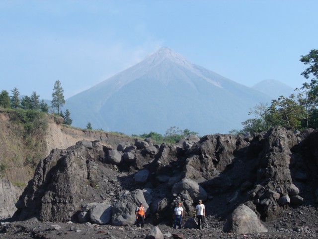 |
Figure 14. The El Jute river channel was a site of major lahar activity at Fuego during tropical storm Agatha in May 2010. This photo was taken 8.7 km SSE from Fuego's summit (seen in the background). The old, dark gray lahar deposits seen here were eroded during the storm leaving this tall 5-m-high scarp. Observers in this 3 May 2011 photo included (from left to right) Marco Antonio Argueta (from the Guatemalan risk group CONRED; Coordinadora Nacional para la Reducción de Desastres), Rosalio Suruy, and Aroldo Surui. Photo by Rüdiger Escobar-Wolf (Michigan Technological University). |
February 2009 photos of a minor eruption. During a field campaign, R. Escobar-Wolf visited Fuego and witnessed explosions that emitted a large number of ballistic blocks (not discussed on table 7). On 6 February he photographed the development of a small ash plume as well as a cloud of remobilized ash that rose from the summit area. Figure 15A was taken seconds after the central plume erupted from the summit. Figure 15B shows continued rise of the plume as well as the onset of remobilized ash from the flanks. Figure 15C is a close-up of the central ravine where, after the impact of the ballistic blocks, trails of material fell from the summit.
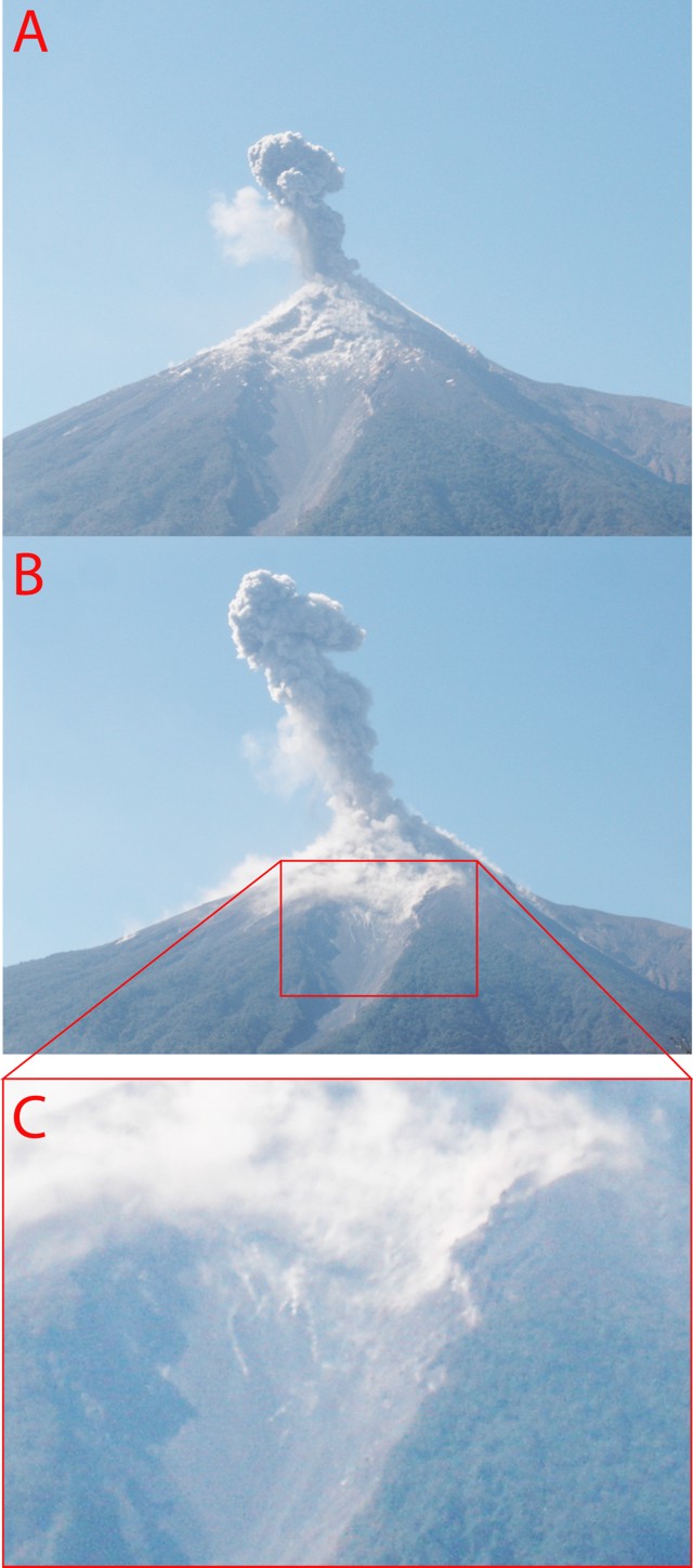 |
Figure 15. A sequence of photos (A-C) taken on 6 February 2009, viewing Fuego towards the WNW. See text for more details. Courtesy of Rüdiger Escobar-Wolf (Michigan Technological University). |
Escobar-Wolf described this sequence of events as a Vulcanian eruption. The eruption was impulsive and released a central plume that reached ~ 1.5 km above the crater (figure 15B). Around the time of this photo, ballistics appeared to impact the summit and thousands of pale ash clouds rose from the summit's surface. These clouds appeared to spread widely down and along the slope, whereas rising portions dispersed (figure 15C).
Recent publications. Characterization of Fuego's activity and the development of new monitoring techniques have been ongoing for several decades. Three manuscripts were recently published focusing on seismic and gas studies.
Erdem (2010) conducted a geophysical study at Fuego from March to July 2008 using a three-component broadband seismometer and two infrasonic microphones. In order to model temporal changes in eruption dynamics, coda wave interferometry methods were used to analyze a set of highly repetitive seismic events associated with regular discrete degassing explosions. The author found rapid temporal variation in the velocity structure, which may indicate minor fluctuations in volatile content or exsolution at various depths between individual explosions. Variations in seismic and acoustic wave arrival times were used to investigate changes in explosion source depth and wind speed.
Lyons and others (2010) found a cyclic pattern in open-vent eruptive behavior at Fuego based on two years of continuous observations from the Fuego Volcano Observatory made possible by a collaboration between the Peace Corps, Guatemalan scientists, and Michigan Technological University. They found that daily observations of lava flow length and explosion characteristics have a strong correlation with satellite-based remote sensing data and tremor amplitude. The pattern of behavior is interpreted to reflect the slow accumulation and periodic gas release in a foam layer trapped in a relatively deep magma chamber or geometric trap in the conduit. This study highlights the importance of detailed geophysical and field observations as a low-cost option in developing countries, as well as in volcanological training.
Nadeau and others (2011) discuss remote sensing of SO2 emissions using a UV camera. Their analysis of 2009 Fuego data sets assessed SO2 emissions from two closely-spaced vents, compared with both visual observations and seismicity. They concluded that tremor and degassing share a common source process, and they developed a model for small, ash-rich explosions based on evidence for rheological stiffening of magma in the upper conduit. Progressive stiffening may explain why, in time-series data, there is a general increase in time lag between tremor and SO2 escape. This lag may be attributed to a deepening or a reduction in velocity of the gas rise from depth if crystallization and cooling propagates downward through time from the top of the magma column. Different degrees of stiffening and the associated range of confining pressures may cause variability in both degrees of explosivity and durations of inter-explosion quiescent periods.
References. Blong, R. J. 1984. Volcanic hazards: a sourcebook on the effects of eruptions. Sydney; Orlando, Fla., Academic Press.
Bonis, S. and Salazar, O. 1973, The 1971 and 1973 eruptions of volcano Fuego, Guatemala, and some socio-economic considerations for the volcanologist, Bulletin Volcanologique, 31 (1), 394-400.
Erdem, J. 2010, Modeling temporal changes in eruptive behavior using coda wave interferometry and seismo-acoustic observations at Fuego Volcano, Guatemala. Michigan Technological University, United States: 2010. GeoRef, EBSCOhost (accessed 19 April 2011).
Lyons, J. J., Waite, G.P., Rose, W., and Chigna, G., 2010. Patterns in open vent, strombolian behavior at Fuego volcano, Guatemala, 2005-2007. Bulletin of Volcanology 72(1): 1-15.
Nadeau, P.A., Palma, J.L., and Waite, G.P., 2011. Linking volcanic tremor, degassing, and eruption dynamics via SO2 imaging. Geophys. Res. Lett., 38: 1-5.
Geological Summary. Volcán Fuego, one of Central America's most active volcanoes, is also one of three large stratovolcanoes overlooking Guatemala's former capital, Antigua. The scarp of an older edifice, Meseta, lies between Fuego and Acatenango to the north. Construction of Meseta dates back to about 230,000 years and continued until the late Pleistocene or early Holocene. Collapse of Meseta may have produced the massive Escuintla debris-avalanche deposit, which extends about 50 km onto the Pacific coastal plain. Growth of the modern Fuego volcano followed, continuing the southward migration of volcanism that began at the mostly andesitic Acatenango. Eruptions at Fuego have become more mafic with time, and most historical activity has produced basaltic rocks. Frequent vigorous eruptions have been recorded since the onset of the Spanish era in 1524, and have produced major ashfalls, along with occasional pyroclastic flows and lava flows.
Information Contacts: Instituto Nacional de Sismologia, Vulcanología, Meteorología e Hidrologia (INSIVUMEH, Ministero de Communicaciones, Transporto, Obras Públicas y Vivienda, 7a. Av. 14-57, zona 13, Guatemala City 01013, Guatemala (URL: http://www.insivumeh.gob.gt/inicio.html); Washington Volcanic Ash Advisory Center (VAAC), NOAA Science Center Room 401, 5200 Auth road, Camp Springs, MD 20746, USA (URL: http://www.ospo.noaa.gov/Products/atmosphere/vaac/); Jemile Erdem, Rüdiger Escobar-Wolf, John Lyons, and Patricia Nadeau, Michigan Technological University, Department of Geological and Mining Engineering and Science, Houghton, MI, USA (URL: http://www.geo.mtu.edu/rs4hazards/index.htm); BBC News (URL: http://www.bbc.co.uk/); Wolfram Alfa Web Resource (URL: http://www.wolframalpha.com/).