Report on Marapi (Indonesia) — July 2011
Bulletin of the Global Volcanism Network, vol. 36, no. 7 (July 2011)
Managing Editor: Richard Wunderman.
Marapi (Indonesia) Increased seismicity in 2004; small ash-bearing eruptions in 2011
Please cite this report as:
Global Volcanism Program, 2011. Report on Marapi (Indonesia) (Wunderman, R., ed.). Bulletin of the Global Volcanism Network, 36:7. Smithsonian Institution. https://doi.org/10.5479/si.GVP.BGVN201107-261140
Marapi
Indonesia
0.38°S, 100.474°E; summit elev. 2885 m
All times are local (unless otherwise noted)
This report first describes a 2005 increase in seismicity at Marapi, then presents a 2010 field map of Marapi's active crater area, and notes several plumes seen in 2011 to 1 km above the vent, some bearing ash. As previously noted, Marapi had generated explosions in 2000 and 2001, and a small ash-bearing eruption in 2004 (BGVN 25:11, 27:01, and 30:01).
Activity during 2005. During the week 8-14 July 2005, the number of earthquakes at Marapi increased dramatically. The seismic network recorded 112 deep volcanic earthquakes, compared to a normal average of 7 per week. Other changes were absent at the volcano, for example, fumarole temperatures were normal and gas emissions typically rose ~ 50 m above the summit. As a result of the increased seismicity, the Center of Volcanology and Geological Hazard Mitigation (CVGHM) raised the Alert Level from 1 to 2 (on a scale of 1-4).
Activity during 2010. During a 4-day visit to Marapi in July 2010, volcanologist Mary-Ann del Marmol created a sketch map of the area (figure 3). More detailed mapping and rock observations of the old crater side of the volcano were thwarted by dense vegetation there.
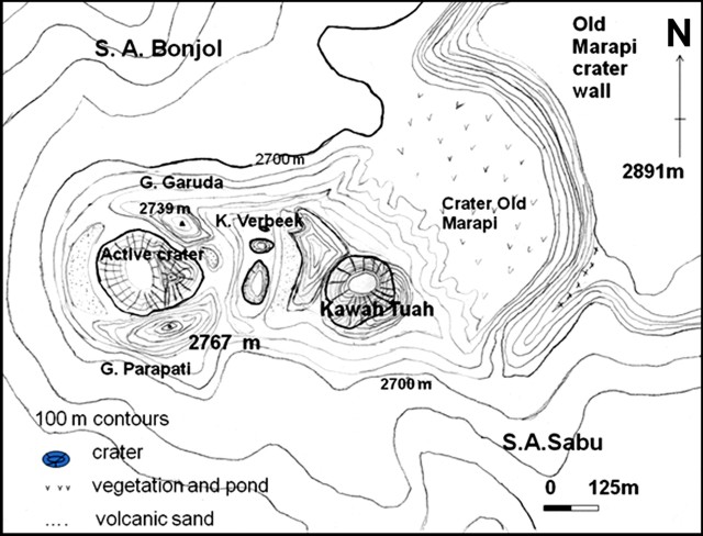 |
Figure 3. A sketch map of Marapi's active crater and vicinity prepared in the course of fieldwork during July 2010. The labels "S.A. Bonjol" and "S.A. Sabu" identify drainages. Courtesy of Mary-Ann del Marmol (University of Ghent, Belgium). |
Activity during 2011. According to CVGHM, seismicity increased during 21 June-3 August 2011. Observers noted that during June, July, and the first day of August white plumes rose 15-75 m above the summit craters. On 3 August dense gray plumes rose 300-1,000 m above the crater on eight occasions. That same day CVGHM raised the Alert Level again to 2. Visitors and residents were prohibited from going within a 3 km radius of the summit.
According to a news article, two eruptions from Marapi occurred on 9 August 2011.
Geological Summary. Gunung Marapi, not to be confused with the better-known Merapi volcano on Java, is Sumatra's most active volcano. This massive complex stratovolcano rises 2,000 m above the Bukittinggi Plain in the Padang Highlands. A broad summit contains multiple partially overlapping summit craters constructed within the small 1.4-km-wide Bancah caldera. The summit craters are located along an ENE-WSW line, with volcanism migrating to the west. More than 50 eruptions, typically consisting of small-to-moderate explosive activity, have been recorded since the end of the 18th century; no lava flows outside the summit craters have been reported in historical time.
Information Contacts: Center of Volcanology and Geological Hazard Mitigation (CVGHM), Jalan Diponegoro 57, Bandung 40122, Indonesia (URL: http://vsi.esdm.go.id/); Mary-Ann del Marmol, Geology and Soil Science Department, University of Ghent, Krijgslaan, 281 S8/A.326, B-9000 Gent, Belgium (URL: http://www.volcanology.ugent.be/delmarmol.htm); Metro TV News (URL: http://www.metrotvnews.com/).