Report on Kirishimayama (Japan) — July 2011

Bulletin of the Global Volcanism Network, vol. 36, no. 7 (July 2011)
Managing Editor: Richard Wunderman.
Edited by Julie A. Herrick.
Kirishimayama (Japan) February 2011 explosions launching ballistics; evacuations
Please cite this report as:
Global Volcanism Program, 2011. Report on Kirishimayama (Japan) (Herrick, J.A., and Wunderman, R., eds.). Bulletin of the Global Volcanism Network, 36:7. Smithsonian Institution. https://doi.org/10.5479/si.GVP.BGVN201107-282090
Kirishimayama
Japan
31.934°N, 130.862°E; summit elev. 1700 m
All times are local (unless otherwise noted)
Our last issue (BGVN 35:12) discussed the explosive eruptions and dome growth from early 2011 (19 January to about 4 February) from the summit crater of Kirishima's Shinmoe-dake. Vulcanian and Subplinian eruptions released enough ash to delay air traffic and prompt evacuations.
Regular ash plumes were observed above the volcano by pilots and with satellite imagery from January 2011 through March 2011 (table 2). More than 140 advisories were issued by the Tokyo Volcanic Ash Advisory Center (VAAC) since the eruption began in January, although only 14 were issued between April and July. Relying primarily on JMA data, this report presents a review of the monthly highlights, followed by a section with tilt, geodetic, and multi-year seismic data.
Table 2. Kirishima ash plumes reported from 22 January through 29 June 2011 based on JMA and VAAC reports with plume heights and drift directions. No plumes were reported for May or July.
| Date | Altitude (km) | Drift |
| 22 Jan 2011 | 1.8-2.1 | SE |
| 26-27 Jan 2011 | 1.8-2.1 | SE |
| 31 Jan 2011 | 2.1 | SE |
| 02-08 Feb 2011 | 1.5-4.6 | SE |
| 03 Feb 2011 | 9.1 | NE |
| 09-11 Feb 2011 | 1.8-4.0 | E, SE |
| 11, 14 Feb 2011 | 4.6-6.1 | -- |
| 18 Feb 2011 | 4.6 | S |
| 24, 28 Feb 2011 | 1.8-2.1 | N, E, and SE |
| 01, 03 Mar 2011 | 3.7 | NE |
| 03, 04, 08 Mar 2011 | 1.5-3.0 | SE |
| 13 Mar 2011 | 5.5-6.1 | E |
| 23 Mar 2011 | 2.4 | SE |
| 29 Mar 2011 | 2.1 | SE |
| 03, 04 Apr 2011 | 4.6-6.1 | E |
| 18 Apr 2011 | 3.7 | SE |
| 23 Jun 2011 | 1.8 | E |
| 29 Jun 2011 | 1.8-2.4 | N |
Peak of Kirishima's 2011 activity. The most dramatic events of the reporting interval took place on 1 and 14 February 2011. JMA field surveyors and local communities reported ballistics from Shinmoe-dake impacted areas up to 3.2 km SW from the crater; these volcanic bombs were from the 1 February eruption. Car windows, solar panels, and roofs were damaged from a shockwave and rock fragments that ranged from lapilli to bombs (up to 0.7 m) (figure 15).
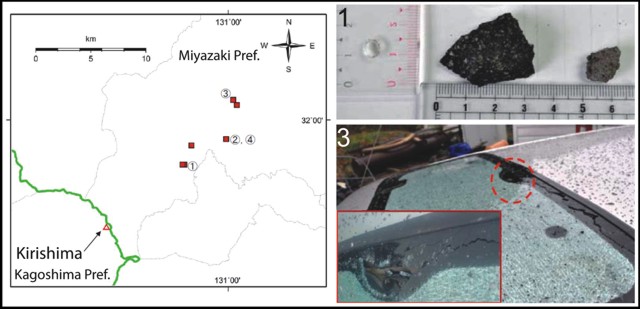 |
Figure 15. JMA investigated several sites within 5 km of Kirishima's Shinmoe-dake, where damage from volcanic bombs was reported. The location map shows political boundaries (gray and green) and investigation sites (red squares). At Site 1, investigators found ballistics larger than 0.3 m; at Site 2, ballistics larger than 0.4 m; at Site 3, broken car windows; and at Site 4, damaged roofs. A map showing the volcano's location off the Korean Peninsula and the main islands of Japan appeared in BGVN 33:09. Courtesy of JMA. |
The largest explosion, at 0754 on 1 February 2011, launched large blocks and juvenile material that impacted the forest to distances of 3.2 km from the crater. Kyushu University recorded oscillations from the impacts of some of these bombs. Investigators from the Earthquake Research Institute of the University of Tokyo visited an impact crater that was surrounded by broken trees; bomb fragments could be found more than 50 m from the crater. Charred wood was found beneath some of the bombs indicating that the material was still hot when it impacted the ground (personal communication, John Lyons, Michigan Technological University).
On 14 February, roofs were damaged when volcanic bombs traveled up to 16 km NE; JMA reported that strong winds that day contributed to these long dispersal distances. According to local news reports, bombs struck and damaged cars parked in the service area of Miyazaki Expressway and they shattered windows in Kobayashi, 13 km NE.
News reports relayed recommendations from civil authorities to evacuate 72,500 people from near Shinmoe-dake due to lahar hazards. Heavy rain had been falling since the previous day and in preparation for expected debris flows, authorities opened primary schools and community centers to shelter residents. At the time of the advisory, 63 people has already evacuated from Miyakonojo, 30 km SE of the crater region.
According to the JMA monthly report, incandescence was visible at night from 26 January to 10 February and also on 28 February. SO2 flux was 11,000-12,000 tons/day during January and averaged 600 tons/day on 25 February. There were 2,037 and 2,506 seismic events in January and February respectively. Tremor was continuous from 26 January to 7 February (a decrease occurred on 29 January). After 7 February, tremor was intermittent.
Activity during March 2011. On 1 March, ashfall was reported E of Shinmoe-dake and a shockwave was felt 3 km from the crater. Ash was deposited to the SW on 3 March and on 13 March ash was reported 60 km E over the Sea of Hyuga. As the intensity of ejections tapered off on 22 March, the restricted zone was reduced from 4 km to 3 km.
According to the monthly JMA report, a sensitive camera recorded night time glow from 1-14 March. SO2 flux averaged 1,300 tons/day on 2 March; however, on 8 March and six subsequent sampling days, the average was 200-500 tons/day. A total of 2,262 seismic events were recorded this month; continuous tremor was recorded from 28 February to 4 March.
Activity during April 2011. Ballistics on 3 April impacted areas as far as 600 m from the crater and ash traveled E to the Hyuga Sea. Ash from 9 April extended ENE and reached a town 60 km from the crater. Ballistics on 18 April impacted the local region as far as 1 km W and N; ash was reported 60 km E, and lapilli reached 9 km from the crater, damaging solar heaters and roof panels in the town of Takaharu.
According to JMA, the average SO2 flux on 2 and 21 April was 100-200 tons/day. A total of 3,840 seismic events were documented in the April report with hypocenters ~ 2 km below the crater; total tremor duration was 42 hours and 13 minutes.
Activity during May 2011. On 13 May, the average SO2 flux was measured at 200 tons/day according to JMA. Seismic stations detected 1,784 events with hypocenters between 0-2 km above sea level near Shinmoe-dake. Total duration of tremor was 1 hour 9 minutes.
Activity during June 2011. On 29 June, ash from an explosion was distributed N and reached the town of Itsuki ~ 50 km N from the crater. Ash from a 16 June eruption reached Takaharu and the city of Kobayashi, 15 km E of the crater. On the 23 June a smaller amount of ash was also observed in Kobayashi. No lapilli or ballistics were associated with these events. According to JMA, rainy weather (common in Japan during early summer) hampered direct observations of the crater. No gas or thermal data was collected. Seismic reports for June documented 4,096 events with hypocenters 0-2 km above sea level and the duration of tremor was 43 hours and 41 minutes.
Activity during July 2011. According to news reports, on 6 July advisories were issued throughout SE Kyushu for torrential rain hazards. Poor weather reduced direct observations of crater activity. JMA reported 3,764 seismic events during this period with 41 minutes of tremor. Earthquake hypocenters were in the same range as past months (0-2 km).
Tilt and geodetic data. Figure 16 plots multiple kinds of data collected during February-July 2011. During the reporting interval, tilt measurements typically indicated inflation on the flanks of Shinmoe-dake hours-to-several-days before explosive events occurred. Conversely, they recorded subsidence immediately after some eruptions. There were also cases of eruptions and explosive events not correlating with tilt. JMA interpreted tilt data as related to the intermittent ascent of magma moving from the chamber to the crater. GPS measurements since February 2011 by the Geospatial Information Authority of Japan suggested a deep magma supply centered several kilometers NW of Shinmoe-dake.
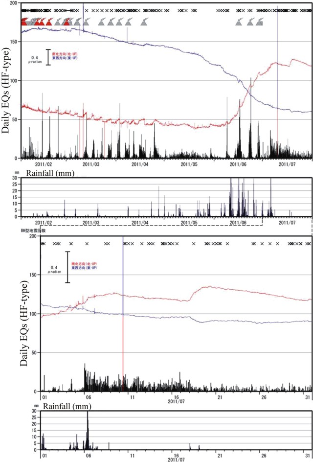 |
Figure 16. Data describing Kirishima for February-July 2011. Plotted together are earthquake counts (per day), rainfall (mm), tilt, eruptions, and ash plumes. Key: tremor "x", explosive eruptions (red triangles), ash plumes (gray triangles), and tilt records showing N-S (red) and E-W (blue). Earthquake counts and rainfall are presented in the black histograms. Lower panels show possible correlation between earthquakes and rainfall that started around 4-6 July 2011. Courtesy of JMA. |
Multi-year seismic data. In the July report, JMA released continuous seismic data for Kirishima during June 2004 through July 2011. Epicenters were located for numerous earthquakes and appeared to concentrate within 2 km of the crater with depths less than 6 km (figure 17).
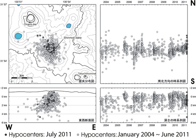 |
Figure 17. Epicenters at Kirishima's Shinmoe-dake as reported by JMA for the interval January 2004 to July 2011. Locations and depths are displayed in cross-sections, including, at right, two plots of earthquakes as a time series, tracking location with time (the lower two rectangles consist of, at left, a conventional E-W cross section, and, at right, the same data in the form of a time series). Note key for shading of data points. Courtesy of JMA. |
During the explosive activity beginning in January 2011, more than 1,000 high frequency earthquakes occurred each month. High frequency (HF) earthquakes are defined as signals greater than 5 Hz (Ishihara and others, 2005). The total number of earthquakes increased and appeared to peak in June with 4,096 high-frequency earthquakes.
Visible and thermal aerial observations. Rapid growth of a lava dome within the Shinmoe-dake crater began on 28 January and was closely monitored by aerial observations. Over the course of 3 days, the dome reached a volume of more than 107 m3 and sustained a diameter of ~ 600 m (BGVN 35:12). Collaboration between the Japan Ground and Air Self-Defense Force (JGSDF-JASDF) provided numerous thermal images as recent as 31 May. During four separate flights in May, white plumes were observed from the SE parts of the dome margin. These plumes reached 50-100 m above the crater rim. Infrared imagery taken during JGSDF-JASDF flights showed no major change since February regarding the heat distribution across the dome and within the crater region. The highest temperatures measured during these flights corresponded to the plume area and the size of the dome had not changed since emplacement.
The Tokyo VAAC reported that on 23 and 29 June, eruptions from Shinmoe-dake produced plumes that rose to an altitude of 1.8 km and 1.8-2.4 km respectively, the first drifted E and the second drifted N. The VAAC reported another eruption on 6 August.
Reference. Ishihara, K., Tameguri, T., Igushi, M., 2005, Automated Classification of Volcanic Earthquakes and Tremors-Outline of the system and preliminary experiment, Annuals of Disaster Prevention Research Institute, Kyoto University, No. 48C.
Geological Summary. Kirishimayama is a large group of more than 20 Quaternary volcanoes located north of Kagoshima Bay. The late-Pleistocene to Holocene dominantly andesitic group consists of stratovolcanoes, pyroclastic cones, maars, and underlying shield volcanoes located over an area of 20 x 30 km. The larger stratovolcanoes are scattered throughout the field, with the centrally located Karakunidake being the highest. Onamiike and Miike, the two largest maars, are located SW of Karakunidake and at its far eastern end, respectively. Holocene eruptions have been concentrated along an E-W line of vents from Miike to Ohachi, and at Shinmoedake to the NE. Frequent small-to-moderate explosive eruptions have been recorded since the 8th century.
Information Contacts: Volcano Research Center, Earthquake Research Institute (VRC-ERI), University of Tokyo, Yayoi 1-1-1, Bunkyo-ku, Tokyo 113, Japan (URL: http://www.eri.u-tokyo.ac.jp/topics/ASAMA2004/index-e.html); Japan Meteorological Agency (JMA), Otemachi, 1-3-4, Chiyoda-ku Tokyo 100-8122, Japan (URL: http://www.jma.go.jp/); Tokyo Volcanic Ash Advisory Center (VAAC), Tokyo, Japan (URL: http://ds.data.jma.go.jp/svd/vaac/data/); Yukio Hayakawa, Gunma University, Faculty of Education, Aramaki 4-2, Maebashi 371-8510, Japan; John Lyons, Michigan Technological University, Dept. of Geological and Mining Engineering and Sciences, 1400 Townsend Drive, Houghton MI, 49931, USA (URL: http://www.geo.mtu.edu/~jlyons/); News On Japan (URL: http://www.newsonjapan.com/); Japan Today (URL: http://www.japantoday.com/); Daily Mail (URL: http://www.dailymail.co.uk/).