Report on Batu Tara (Indonesia) — October 2011
Bulletin of the Global Volcanism Network, vol. 36, no. 10 (October 2011)
Managing Editor: Richard Wunderman.
Batu Tara (Indonesia) Advisories and images in 2010-2011; airline routes; 2011 eruption
Please cite this report as:
Global Volcanism Program, 2011. Report on Batu Tara (Indonesia) (Wunderman, R., ed.). Bulletin of the Global Volcanism Network, 36:10. Smithsonian Institution. https://doi.org/10.5479/si.GVP.BGVN201110-264260
Batu Tara
Indonesia
7.791°S, 123.585°E; summit elev. 633 m
All times are local (unless otherwise noted)
This report examines the tectonic setting of Batu Tara, Indonesia, and volcanic activity between February 2010 and October 2011. A map details the tectonics of portions of the Indonesian and Australian plates in the region (Elburg, 2005). Batu Tara lies along some critical air routes that link Asia to Australia. Sonnabend (2007) discussed alternate routes to avoid plumes from Batu Tara at a conference on volcanic ash in 2007. Satellite imagery from the NASA Earth Observing System (EOS) in 201 showed the islands volcanic features and complex plume dispersion.
The Darwin Volcano Ash Advisory Centre (VAAC) produced more than 40 ash plume advisories. The majority of the Darwin VAAC advisories stemmed from plume detection by the Japan Meteorological Agency's MTSAT-1 and two satellites. Lastly, during 17-19 August 2011, Thorsten Boeckel and others witnessed Batu Tara in eruption; they collected photos, videos and recorded the event.
Batu Tara (figure 6) lies 55 km from Timor, the nearest large island. Maumere, the largest town in the region (pop. 70,000; United Nations Department of Humanitarian Affairs, 1992), resides on the N coast of Flores Island, Indonesia, 175 km WSW from Batu Tara. Batu Tara sits 947 km NE of Darwin, Australia, 1,860 km W of Jakarta and 2,410 km SW of the Republic of Singapore.
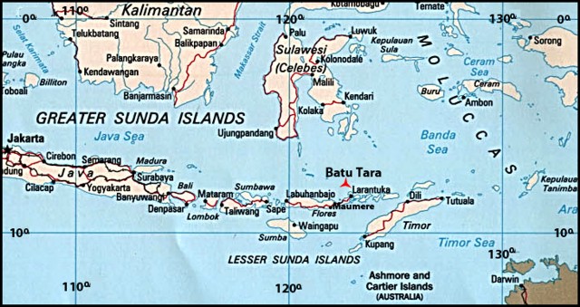 |
Figure 6. Batu Tara volcano (red triangle) in the Indonesian Archipelago. Revised from Google and Tele Atlas. |
Geologic setting and plate tectonics. Volcanism in Indonesia, as shown in figure 7, is characterized by the northward subduction of the Australian plate beneath the Indonesian plate. According to Elburg (2011), volcanoes in the area to the S of the Weber thrust (consisting of the islands Alor, Atauro, Wetar, and Romang) became extinct 3.5-1.8 million years ago. This tectonic region delineates a complex of thrusting, trough, trench, basin, ridge, crust, plateau and continental plate features forming a constellation of volcanoes. The principal geologic features relevant to Batu Tara are its proximity to the subduction zone and the local distribution of active volcanism. It has erupted potassic leucite-bearing basanitic and tephritic rocks intermittently since 1 July 2006, following a dormancy dating back to 1847-1852. Starting in January 2007, observers issued reports of ash plumes from explosive activity. Darwin VAAC recorded 7 to 10 months of plume descriptions per year during 2008 through October 2011.
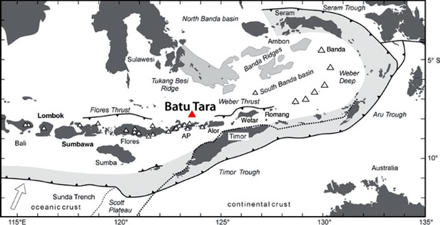 |
Figure 7. Map delineating inferred regional-scale tectonics surrounding Batu Tara. Revised from Elburg (2011). |
Darwin VAAC Advisories. The Darwin VAAC advisories for this reporting period began on 8 March 2010 (table 4). From 8 March 2010 through 30 Oct 2011, 41 advisories were released. The reports specified ash plume altitude and dispersal direction. No reports were filed for February, November and December of 2010. After a pause in late October 2010, advisories began again in March 2011and continued through 30 October, the end of the reporting period. The most frequent and highest plumes occurred during approximately the same times of both years.
Table 4. Representative Darwin VAAC Advisories listing Batu Tara ash plumes during 2010-2011. Many plumes drifted N to SW, corresponding to the trade winds.
| Date | Plume top altitude (km) | Drift direction(s) and extent |
| 08-09 Mar 2010 | 1.5-2.4 | 45-120 km W and NW |
| 10-16 Mar 2010 | 2.1-2.4 | 20-150 km N, NW, W, SW, and SSE |
| 17-18, 22-23 Mar 2010 | 2.4 | 30-95 km NW |
| 24-26 Mar 2010 | 2.4 | 10-120 km W, NW, and NE |
| 05 Apr 2010 | 2.1 | More than 35 km N |
| 06-11 Apr 2010 | 2.1 | 25-75 km NW, NE, E, and SE |
| 25-27 Apr 2010 | 2.1 | 45-85 km W and N |
| 28, 30 Apr 2010 | 2.1-2.4 | 35-95 km SW, W, and NW |
| 20 May 2010 | 2.4 | 65 km W |
| 02-07 Jun 2010 | 2.4 | 20-65 km W, NW, and N |
| 09, 11-15 Jun 2010 | 2.4 | 35-65 km W and NW |
| 19-20 Jun 2010 | 3.0 | More than 35 km NW |
| 18-20 Jul 2010 | 1.5 | More than 35 km NW |
| 21 Jul 2010 | 1.5 | 55 km NW |
| 30-31 Jul 2010 | 1.5 | 65 km NW |
| 09-10 Aug 2010 | 1.5 | NW and SW |
| 13-17 Aug 2010 | 1.5-3 | 35-95 km NW and W |
| 20-23 Aug 2010 | 1.5 | 25-65 km NW and W |
| 26-28 Aug 2010 | 1.5 | 55-75 km W and 27-28 NW |
| 01-03 Sep 2010 | 1.5 | 45-65 km W and NW |
| 08 Sep 2010 | 2.4 | 55 km NW |
| 18-20 Sep 2010 | 1.5 | 35-95 km W and NW |
| 06 Oct 2010 | 1.5 | 55 km W |
| 20 Mar 2011 | 2.1 | Less than 30 km NE |
| 28 Apr-03 May 2011 | 3 | 10-130 km N, NW, W, and SW |
| 04-07 May 2011 | 0.9-2.1 | 18-75 km NW, W, and SW |
| 15-17 May 2011 | 1.8 | 75-130 km W and NW |
| 18-23 May 2011 | 1.8-2.4 | 75-110 km W, NW, and N |
| 24-27 May 2011 | 2.4 | 40 km W, NW, and N |
| 01-07 Jun 2011 | 1.8 | 40-130 km NW, W, and SW |
| 08-13 Jun 2011 | 2.4 | 55-75 km NW, N, and E |
| 16-20 Jun 2011 | 2.4 | 55-75 km W, NW, and N |
| 22-25 Jun 2011 | 2.4 | 35-75 km W and NW |
| 01-03 Jul 2011 | 2.4 | 75 km NW |
| 09-11 Jul 2011 | 1.5-3.0 | 75 km W and NW |
| 23-30 Aug 2011 | 2.1 | 20-90 km N, NW, and W |
| 08-13 Sep 2011 | 2.1 | 37-65 km NW and W |
| 13-20 Sep 2011 | 2.1 | 25-75 km W,WNW and NW |
| 21-24 Sep 2011 | 2.1 | 37-65 km W, WNW, and NW |
| 27 Oct 2011 | 2.1 | 45 km W |
Batu Tara plume heights ranged from ~ 1 to 3 km altitude, the majority of which were near 2 km in height. Plumes dispersed mostly in westerly directions.
Commercial airline routes. Sonnabend (2007) discussed avoiding ash plumes from Batu Tara on the airline routes between Jakarta and Sidney. He reported "When the pilot smells the sulfur it is too late to escape. Therefore it is essential that, with respect to a safe flight, the information about a volcanic eruption will be passed immediately to the airlines and pilots in flight. Standardized products of describing volcanic ash events in text or graphical form are used by flight crews, dispatchers and also automated systems in order to support the decision making process in view of a safe and economic flight operation."
An example (figure 8) shows the normal route (blue, in the middle) and two alternate ones (black to the E, red to the W).
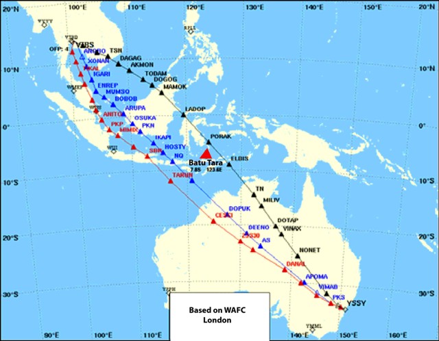 |
Figure 8. Alternate flight advisory routes due to Batu Tara plumes (red and black) between Sidney and Jakarta. The central route (blue) is the normal route. Revised from Sonnabend (2007). |
Table 5 compares time, fuel, and cost resources of the nominal route with the two alternates. The alternate routes cost 3-5 minutes of additional flight time, 1353-1690 kg of fuel, and up to ~ $60 USD per minute. When confronted with the immediacies of ash advisories, this example typifies the decision-making process by a commercial airline confronted with eruptive plumes where changing the flight path adds costs. This is especially true when there are many flights per day or when other routes overlap the same region. The consequences of even minor route deviations could improve safety but add cost and flight time weighed against the possibility of damage from ash.
Table 5. Comparisons of the normal Jakarta-Sidney air route compared to nearby alternate routes that avoid passing over Batu Tara (see figure 8). From Sonnabend, 2007.
| Flight route, color | Time | Trip fuel | Costs, USD |
| Black | 8h 54m | 87402 kg | $59,427 |
| Red | 8h 56m | 87065 kg | $58,679 |
| Blue (normal) | 8h 51m | 85712 kg | $58,391 |
NASA EOS Images. The Moderate Resolution Imaging Spectroradiometer (MODIS) sensor aboard the AQUA satellite acquired an image (figure 9) on 15 March 2010. The plume dispersed S, then immediately split, drifting SE and SW. Other areas to the E and W appear to be residual plumes, but their origin was not mentioned in the EOS report. Notice the bottom of the E plume reversed direction, arcing W. An earlier plume near the crater in the NE sector of the image moved NE along an arc.
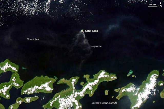 |
Figure 9. Wind driven ash plumes from a Batu Tara eruption on 15 March 2010. Courtesy of Jeff Schmaltz, NASA Earth Observatory. |
Another NASA EOS image (figure 10), acquired on 6 August 2010, showed material extending from the E shore. The N-S diameter of the island is ~ 3 km; the E scarp of the crater extends ~ 700 m to the sea. A large-scale view from a different satellite instrument (MODIS) on the same day showed that the plume extended W from Batu Tara before it disappeared under a bank of weather clouds.
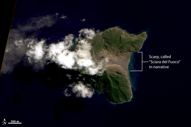 |
Figure 10. A NASA EO-1 ALI sensor image of Batu Tara erupting on 6 August 2010. The scarp on the E side of the island is referred to as the "Sciara del Fuoco" in Thorsten Boeckel's narrative. Revised from NASA Earth Observatory, Robert Simmon. |
Summer trade winds. Winds aloft play a significant role in three sections of this report: advisories, air routes, and plume-satellite images (e.g. figure 9). The winds at Batu Tara area are often described as trade winds (figure 11). The trades, the most consistent of the Earth's wind systems, with an average altitude of ~ 0.9-1.5 km, are characterized by direction and, to a lesser degree, speed (Glickman, 2000).
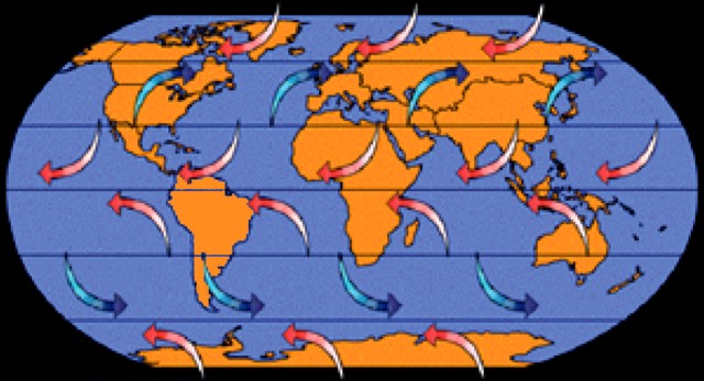 |
Figure 11. A highly simplified depiction of the Earth's wind system showing the trade winds near the equator in light red. At Batu Tara they would be expected to blow to the W and many of the plume dispersal noted in table 4 have a westerly component. From NOAA National Ocean Service Education. |
The trades (figure 11) vary seasonally and have other complexities. They meet at the Intertropical Convergence Zone (ITCZ), which norminally lies near the equator. However, the ITCZ shifts to the N and S of the equatorial median, typically ranging from ~ 1,500 km S in January to ~ 3,300 km N above the Indonesian Archipelago in July (figure 12; Lutgens and Tarbuck, 2001).
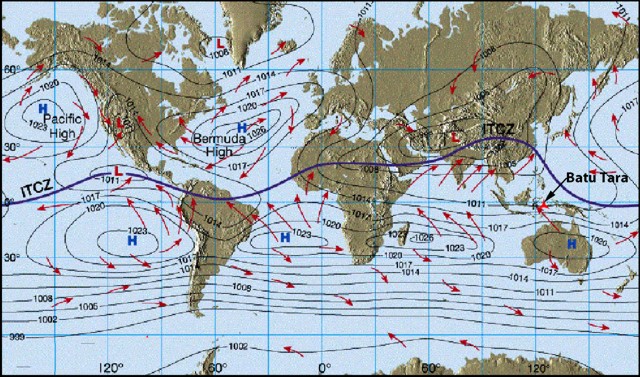 |
Figure 12. Northern shift of the ITCZ in July above Indonesia; Batu Tara in red. From Lutgens and Tarbuck (2001). |
In July, just N of the equator, below the displaced ITCZ, the winds move counter to those below the equator, pushing E instead of W. These two sources, the nominal trade wind and the NW wind located S of the shifted July ITCZ near Batu Tara, disrupt the normal trade wind pattern. This system of multiple winds (more complex than the cartoon shown in figure 11), along with the shifts in winds with altitude, and other factors (such as sea surface conditions) play roles in dispersal of Batu Tara ash plumes.
Eye-witness observations. Thorsten Boeckel and others recorded videos and photos, and noted impressions of Batu Tara's eruptions during 17-19 August 2011. Boeckel's group landed on the island in the morning of 17 August and continuously documented during the day and night. More details of their adventure can be found on the internet (see Information Contacts); several of Boeckel's photos appear in figures 13 and 14.
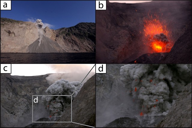 |
Figure 13. Four photos of Batu Tara taken during 17-19 August 2011. a) The scarp from offshore looking N. b) A daytime photograph of a Strombolian eruption, with top edge of the crater almost out of view (except for a trace of the sky at top center and left). c) Near the summit looking WNW, just left of the crater, with a plume rising on the right. d) An enlargement (~400%) of c) showing incandescent spatter ejected from the vent. Courtesy of Thorsten Boeckel. |
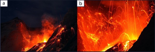 |
Figure 14. Photographs of night-time eruptions of Batu Tara during 17-19 August 2011. a) A view near the summit shows lava funneling down a chute just beyond the margin of the slope (out of view) with a secondary flow facing the viewer. b) Incandescent lava bombs ejected from the summit; lava to the left of the crater is traveling downslope in the scarp. Courtesy of Thorsten Boeckel. |
In Boeckel's words, "The local maps fail to locate Batu Tara. In Larantuka in East-Flores, where the adventurers sighted volcanic plumes on Batu Tara they booked passage on a tuna vessel for the 7 hour trip ignoring gossip from local fishermen that the island is enchanted. After about 5 hours we could recognize the Batu Tara Island. From a distance of 15 km we could see ash clouds over the island.
"During the approach we noticed increasingly that this volcano is a true stone block in the sea. Hence, would we be able to land? That evening, we reached the backside [ E side] of the island and saw the 'Sciara del Fuoco'. And really, this volcano must be the twin volcano of Stromboli. Even the summit, the Pizzo and the fire chute turned away from the mainland resemble Stromboli. The crater is approximately two-thirds the height, surrounded by a powerful steep crater funnel.
"The next morning a landing site was chosen. About 100 m beside the Sciara a narrow landing strip appeared. A skillful native fisherman whom we had onboard ferried our equipment onto the strip. [Ascending] the very steep area would take an immense expenditure of time. After landing, the equipment was set up near the summit recording the ongoing Strombolian eruption.
"The active Strombolian activity was most vigorous. At intervals of 15 minutes we noted many smaller eruptions. Larger outbreaks, 300-400 m high also occurred at 30-45 minute intervals. Those on the boat viewed lava ejecting far over crater edge. Often the forest was bombarded ~ 200 meters below the crater.
"The night began, and in addition to the fascinating lava show [figure 14], the eruption noise was a highlight. Even ~ 700 meters away, the ground tremored during stronger outbreaks.... The fire chute appears impressive, large plastic lava constantly flowed from the crater. At night bouncing rocks from the lava-flow entering the water created loud explosions."
The eruptions continued as the ship traveled E that night. A photograph, taken from the ship after a day spent on the island, shows the slope angle of the scarp (figure 15). The shot was taken too far away to show lava bombs hitting and skipping along the water's surface, however, such behavior was observed.
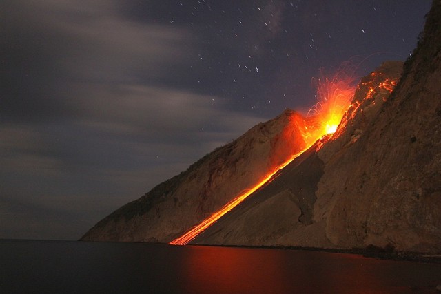 |
Figure 15. A long exposure, evening, shipboard photograph of lava blocks rolling down Batu Tara's scarp. Courtesy of Thorsten Boeckel. |
References. Boeckel T., Rietze, M., Szeglat M., and Weber, C., 2011, Indonesia 2011: Batu Tara, URL: http://www.tboeckel.de/EFSF/efsf_wv/indonesia_11/Batu Tara/Batu Tara 2011_e.hth; Posted 03 August 2011; accessed 23 November 2011.
Elburg, M., 2005, Indonesian Magmatism (URL: http://users.ugent.be/~melburg/Indonesia/IndonesiaElburg.html) Updated 10 August 2005; accessed 23 November 2011.
Glickman, T.S., 2000, Glossary of Meteorology, American Meteorology Society, 2nd ed., 850 p.
Lutgens, F.K. and Tarbuck, E.J., 2001, The Atmosphere, An Introduction to the Atmosphere, Prentice Hall, 8th Ed., 484 pp., Figure 7.9.
Sonnabend, H.R., 2007, Airlines, Aircrafts and Volcanic Ash, World Meterological Association (WMO) Fourth International Workshop on Volcanic Ash, Rotorua, New Zealand, 26-30 March 2007, report number VAWS/4 WP/07-04.
United Nations, Department of Humanitarian Affairs, 1992, Indonesia-Earthquake, DHA-UNDRO Information Report No. 2, 13 December, 1992; DHA-UNDRO 92/0817.
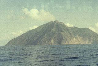
Geological Summary. The small isolated island of Batu Tara in the Flores Sea ~50 km N of Lembata (fomerly Lomblen) Island and the main volcanic arc. A scarp on the eastern side reaches the sea, and vegetation covers the other flanks to within 50 m of the summit. This volcano is noted for its potassic leucite-bearing basanitic and tephritic rocks. The first recorded eruption, during 1847-52, produced explosions and a lava flow.
Information Contacts: Darwin Volcanic Ash Advisory Centre (VAAC), Bureau of Meteorology, Northern Territory Regional Office, PO Box 40050, Casuarina, NT 0811, Australia (URL: http://www.bom.gov.au/info/vaac/); NASA Earth Observatory, NASA Goddard Space Flight Center (URL: http://earthobservatory.nasa.gov/); Thorsten Boeckel (URL: http://www.tboeckel.de).