Report on Hierro (Spain) — October 2011
Bulletin of the Global Volcanism Network, vol. 36, no. 10 (October 2011)
Managing Editor: Richard Wunderman.
Edited by Robert Dennen.
Hierro (Spain) Precursors leading to a shallow submarine eruption in 2011
Please cite this report as:
Global Volcanism Program, 2011. Report on Hierro (Spain) (Dennen, R., and Wunderman, R., eds.). Bulletin of the Global Volcanism Network, 36:10. Smithsonian Institution. https://doi.org/10.5479/si.GVP.BGVN201110-383020
Hierro
Spain
27.73°N, 18.03°W; summit elev. 1500 m
All times are local (unless otherwise noted)
A submarine eruption at Hierro volcano, Canary Islands, Spain, represents the first documented historical activity, although a flank eruption may have occurred in 1793. A satellite photo shows El Hierro island and the sea surface expression of the submarine eruption on 26 October 2011 (figure 1). For clarification, the name "Hierro" refers to the volcano (as listed in the GVP database), while the name "El Hierro" refers to the island constructed by the volcano; this naming convention will be followed in this report. Unless otherwise noted, all data concerning the pre-eruptive and eruptive activity at Hierro was reported by Instituto Geográfico Nacional (IGN).
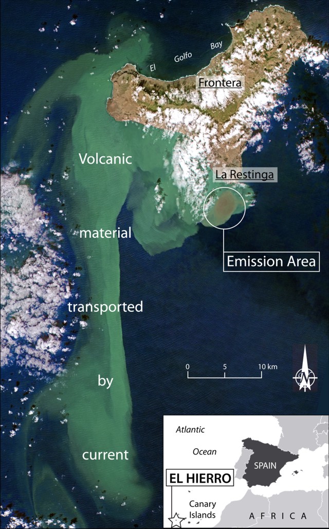 |
Figure 1. Annotated satellite photograph of El Hierro island on 26 October 2011 highlighting the emission area (discolored brown water, circled) and volcanic material transported by ocean currents, appearing light blue-green; settlement names are underlined. (Inset) Geographic location of El Hierro island, in the Canary Islands, off the W coast of Africa. Satellite image courtesy of RapidEye; index map modified from Mapsof.net. |
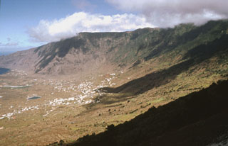
Pre-eruptive activity. Increased seismicity at El Hierro beginning 16 July 2011 marked the onset of pre-eruptive activity. More than 6,000 seismic events had occurred by the beginning of September; seismic events were less than M 3, and hypocenters were located at ~10 km depth beneath the area of the now-collapsed El Golfo volcano (El Golfo Bay, on the N side of the island; figure 1). The increased seismicity was accompanied by 2 cm of ground inflation and increased CO2 flux over the same time period. Following a significant increase in both seismic energy release rates (figure 2) and ground deformation rates, the Canarian Autonomous Government raised the Alert Level to Yellow on 23 September (on a 3 color scale; Green, Yellow, and Red).
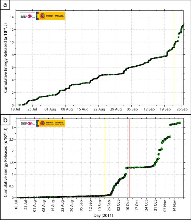 |
Figure 2. Cumulative energy (units of joules) registered by a seismometer monitoring El Hierro. a) Seismicity during 18 July-27 September 2011 highlighting pre-eruptive activity; yellow line indicates the beginning of Yellow Alert Level on 23 September. Slope increase around 20 September indicates increased seismicity. b) Seismicity during 18 July-18 November congruent with eruptive activity; yellow and red lines indicate the beginning of Yellow alert (23 September) and Red alert (11 October); dashed black line indicates the onset of volcanic tremor. Note the change in scale on the y-axis, from 1010 (a) to 1012 (b). Courtesy of Instituto Geográfico Nacional (IGN). |
In the first week of October, seismic hypocenters were located offshore SW of El Hierro island. The next week, an M 4.3 earthquake occurred on 8 October, 1.5 km offshore to the SW, at ~ 14 km depth. This was the largest magnitude precursory seismic event. During 8-9 October, following the 8 October earthquake, ground deformation trends changed, suggesting deflation. Coinciding low magnitude earthquakes occurred at 2 km depth to the SW of the island, and tremor commenced at about 0515 on 10 October, with the highest amplitudes measured at the S-most seismic station. IGN said, "data suggested a submarine eruption."
Red alert due to submarine eruption. At 0700 on 11 October, the amplitude of tremor increased; the same day, the Government of the Canary Islands raised the Alert Level to Red for La Restinga village (figure 1), and residents were evacuated. A maritime exclusion zone was extended to ~4 nautical miles from the coast on the S end of the island.
Within the next week, visual evidence of the eruption was observed. On 12 October, a large area of the ocean to the S of La Restinga village was discolored, and a small, intensely discolored area was identified as the emission area. On 15 October, viewers in a helicopter observed steaming lava fragments floating in the emission area (figures 3 and 4). Further emission episodes occurred as large, turbulent rings of gas or foam reached the sea surface. Contemporaneously, tremor amplitude and deformation decreased, but in the N part of the island, significant inflation-deflation episodes ensued. Seismic activity at the N of the island continued, highlighting a NNW-SSE trend extending ~13 km from the center of the island at 20-25 km depth.
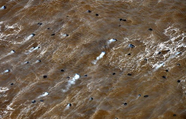 |
Figure 3. Steaming blocks of vesicular lava floating in the ocean after eruption at Hierro on 15 October. The water is discolored from the eruption. Courtesy of Instituto Geográfico Nacional (IGN). |
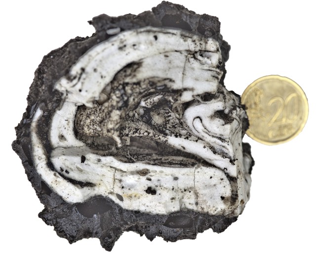 |
Figure 4. Sample of erupted material collected floating on the sea on 18 October 2011; coin for scale. According to Gobierno de Canarias, Plan de Protección Civil por Riesgo Volcánico (PEVOLCA) the pyroclasts were predominantly basalt (black) with lesser amounts of trachyte (white). Courtesy of Instituto Geográfico Nacional (IGN). |
Further emission episodes occurred during early November, with turbulent water, foam rings, and volcanic material again reaching the sea surface (figure 5). On 5 and 8 November, especially large bubbles rose to the surface, and they ejected sea water and volcanic material a few meters above the surface; video footage of this phenomenon was captured by Radio Televisión Canaria (RTVC) on 8 November and other dates.
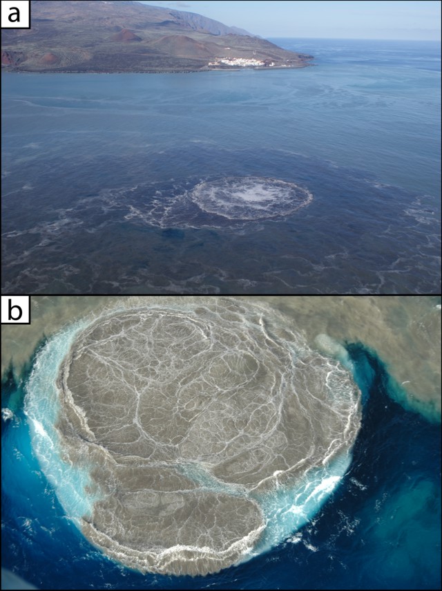 |
Figure 5. Photographs of large gas bubbles and foam reaching the sea surface at Hierro. a) Photograph taken on 8 November 2011, highlighting the proximity of the emission area (bubbles breaching the sea surface in foreground) to the village of La Restinga (background). b) Detail of a breaching gas bubble on 5 November 2011; upper peripheral parts of the image show intensely discolored seawater as compared with relatively uncontaminated seawater seen in the bottom peripheral parts of the image. Both photographs taken from helicopter flights. Courtesy of Instituto Geográfico Nacional (IGN). |
Increasing seismicity included an M 4.4 earthquake on 5 November (the eruptive episode's largest as of 8 November). The "Plan de Protección Civil por Riesgo Volcánico" (PEVOLCA) required the evacuation of 51 residents from the settlement Frontera (figure 1) due to landslide risks, and the evacuation of about 200 residents from La Restinga. On 14 November, authorities allowed residents of La Restinga to return to their homes, but children were to attend school in another town, El Pinar. Two buses remained in La Restinga for re-evacuation use, if necessary.
Lava composition, eruption rate, sea-water acidity and gas flux; fish kills. The lava erupted by Hierro was reported by Gobierna de Canarias (analyzed by PEVOLCA) to be predominantly basalt with lesser amounts of trachyte (an approximate basalt-to-trachyte ratio of 10:1; figure 4). They reported that the pyroclasts formed from magma mixing at the time of the eruption. They inferred that the lavas were physical mixtures.
According to Gobierno de Canarias, researchers for the Instituto Español de Oceanografia (IEO) acquired underwater Digital Terrain Maps (DTM; figure 6) during 24-28 October, and estimated that, in that short time, the volcano erupted nearly 5.5 x 10⁶ m3 of material. IEO also measured a decrease in seawater pH from 7.97 to 5.45 within 5 m of the sea surface in the area of the eruption. Furthermore, Gobierno de Canarias reported that Instituto Tecnológico y de Energías Renovables (ITER) estimated the release of CO2 and H2S into the atmosphere at up to 54 and 36 tons/day, respectively.
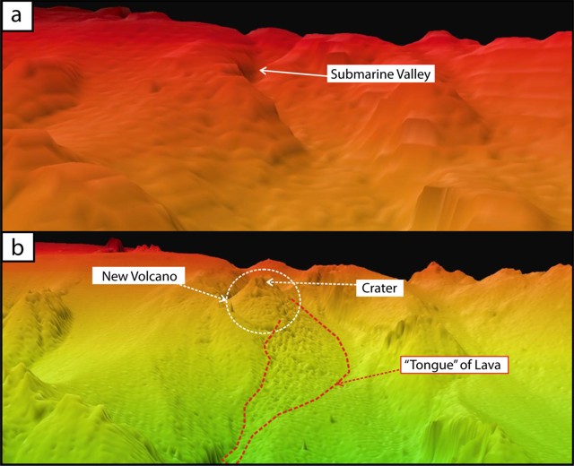 |
Figure 6. Underwater Digital Terrain Maps (DTM) a) acquired in 1998 and b) 24 October 2011, collectively highlighting morphologic changes in the submarine vent area offshore of El Hierro island. Further DTMs acquired through 28 October 2011 allowed the Instituto Español de Oceanografia (IEO) to estimate the mass eruption rate to be nearly 5.5 million m3 of material during 24-28 October. Courtesy of IEO. |
RTVC reported the death of fish that could not escape the eruption. IGN stated that "Preliminary reports of analyses... suggest that the cause of fish kills is related to the ongoing volcanic processes."
Editor's note: As this issue went to press, the Instituto Volcanologico de Canarias (INVOLCAN) announced a new video channel (Youtube, 2011).
Reference: Instituto Volcanologico de Canarias (INVOLCAN), 2011, Submarine eruption at El Hierro, Canary Islands (Spain), YouTube Video Channel (URL: http://www.youtube.com/user/INVOLCAN).
Geological Summary. The triangular island of Hierro is the SW-most and least studied of the Canary Islands. The massive shield volcano is truncated by a large NW-facing escarpment formed as a result of gravitational collapse of El Golfo volcano about 130,000 years ago. The steep-sided scarp towers above a low lava platform bordering 12-km-wide El Golfo Bay, and three other large submarine landslide deposits occur to the SW and SE. Three prominent rifts oriented NW, NE, and S form prominent topographic ridges. The subaerial portion of the volcano consists of flat-lying Quaternary basaltic and trachybasaltic lava flows and tuffs capped by numerous young cinder cones and lava flows. Holocene cones and flows are found both on the outer flanks and in the El Golfo depression. Hierro contains the greatest concentration of young vents in the Canary Islands. Uncertainty surrounds the report of an eruption in 1793. A submarine eruption took place about 2 km SSW off the southern point of the island during 2011-12.
Information Contacts: Instituto Geográfico Nacional (IGN), C/ General Ibáñez de Ibero, 3. 28003, Madrid, España (URL: http://www. ign.es/); RapidEye, RapidEye AG, Molkenmarkt 30, 14776 Brandenburg an der Havel, Germany (URL: http://www.rapideye.de/); Mapsof.net (URL: http://mapsof.net/); Radio Televisión Canaria (URL: http://rtvc.es/); Gobierno de Canarias (URL: http://www.gobiernodecanarias.org/); Instituto Español de Oceanografia (IEO) (URL: http://www.ieo.es/).