Report on Martin (United States) — January 2012
Bulletin of the Global Volcanism Network, vol. 37, no. 1 (January 2012)
Managing Editor: Richard Wunderman.
Edited by Robert Dennen.
Martin (United States) Seismic swarm in January 2006
Please cite this report as:
Global Volcanism Program, 2012. Report on Martin (United States) (Dennen, R., and Wunderman, R., eds.). Bulletin of the Global Volcanism Network, 37:1. Smithsonian Institution. https://doi.org/10.5479/si.GVP.BGVN201201-312140
Martin
United States
58.172°N, 155.361°W; summit elev. 1863 m
All times are local (unless otherwise noted)
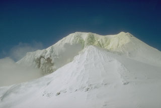
Activity at Mount Martin volcano since our last report (March 1995, BGVN 20:03) was marked by typical activity (summit fumarolic activity, often generating thick steam plumes reaching up to 1 km above the summit; Neal and others, 2009), occasionally interrupted by increased seismicity. The most notable event was a seismic swarm in January 2006.
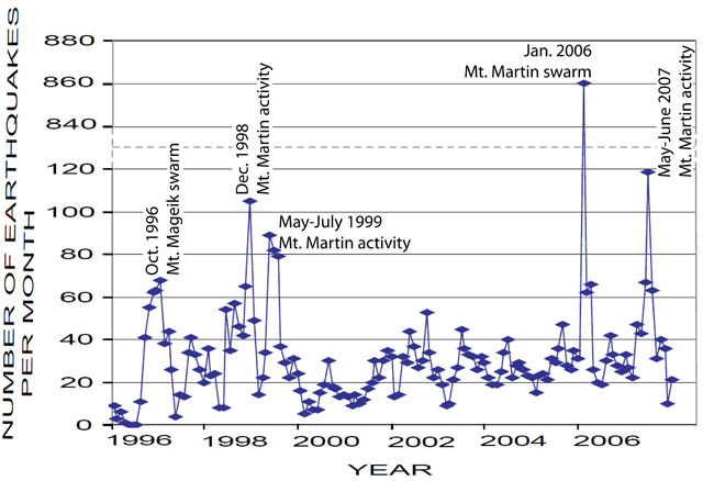
Outstanding activity. An increase in seismicity during October 1996 was attributed to an actively degassing intrusion at the neighboring Mount Mageik volcano, ~7 km ENE of Martin (Jolly and McNutt, 1999). Other increases in seismicity occurred in December 1998, May-July 1999, January 2006 (the largest swarm at Martin since it has been monitored, discussed below), and May-June 2007 (figure 1).
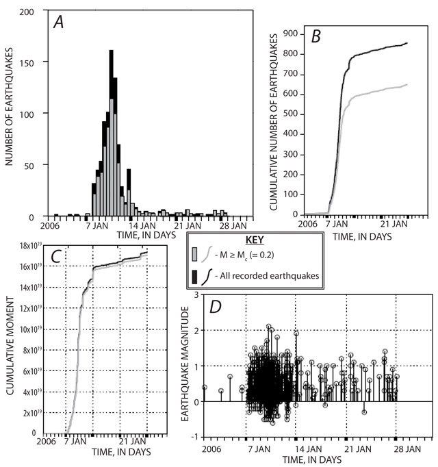
January 2006 seismic swarm. The January 2006 Mount Martin seismic swarm included 860 locatable earthquakes (figures 1 and 2), more than four times the number of earthquakes seen during other periods of increased seismicity or seismic swarms since the region has been monitored. No recorded earthquakes during the swarm were much greater than M 2 (figure 2d), and a significant number of earthquakes were of magnitudes below the magnitude of completeness, Mc (figure 2a-c). Mc is the minimum magnitude needed to reliably locate an earthquake, reported by Dixon and Power (2009) to be Mc = 0.2 for Mount Martin.
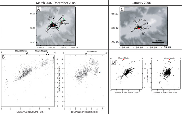
Dixon and Power (2009) concluded that the pattern of the seismicity of the January 2006 swarm was characteristic of a volcanic earthquake sequence (as opposed to a tectonic earthquake sequence, which begins with a large mainshock) since the located hypocenters of the swarm occurred in the same space as those during previous background periods (figure 3). However, citing the short duration of the swarm, similar focal mechanisms compared to background periods, and the lack of long-period earthquakes, Dixon and Power (2009) stated that the data was not suggestive of a large intrusion of magma beneath Martin.
References. Dixon, J.P., and Power, J.A., 2009, The January 2006 Volcanic-tectonic earthquake swarm at Mount Martin, Alaska, in Haeussler, P.J., and Galloway, J.P., eds, Studies by the U.S. Geological Survey in Alaska, 2007: U.S. Geological Survey Professional Paper 1760-D, 17 p.
Jolly, A.D., McNutt, S.R., 1999, Seismicity at the volcanoes of Katmai National Park, Alaska; July 1995-December 1997, Journal of Volcanology and Geothermal Research, vol. 93, issues 3-4, pg. 173-190 (DOI: 10.1016/S0377-0273(99)00115-8).
Neal, C.A., McGimsey, R.G., Dixon, J.P., Manevich, A., and Rybin, A., 2009, 2006 Volcanic Activity in Alaska, Kamchatka, and the Kurile Islands: Summary of Events and Response of the Alaska Volcano Observatory, U.S. Geological Survey Scientific Investigations Report 2008-5214, 102 p.
Geological Summary. The mostly ice-covered Mount Martin stratovolcano lies at the SW end of the Katmai volcano cluster in Katmai National Park. The volcano was named for George C. Martin, the first person to visit and describe the area after the 1912 eruption. It is capped by a 300-m-wide summit crater, which is ice-free because of an almost-constant steam plume; it also contains a shallow acidic lake. The edifice was constructed entirely during the Holocene, and overlies glaciated lava flows of the adjacent mid- to late-Pleistocene Alagoshak volcano to the WSW. Martin consists of a small fragmental cone that was the source of ten thick overlapping blocky dacitic lava flows, largely uneroded by glaciers, that descend 10 km to the NW, cover 31 km2, and form about 95% of the eruptive volume of the volcano. Two reports of historical eruptions that originated from uncertain sources were attributed by Muller et al. (1954) to Martin.
Information Contacts: Alaska Volcano Observatory (AVO), a cooperative program of a) U.S. Geological Survey (USGS), 4200 University Drive, Anchorage, AK 99508-4667 USA (URL: http://www.avo.alaska.edu/), b) Geophysical Institute, University of Alaska, PO Box 757320, Fairbanks, AK 99775-7320, USA, and c) Alaska Division of Geological & Geophysical Surveys (ADGGS), 794 University Ave., Suite 200, Fairbanks, AK 99709, USA (URL: http://www.dggs.alaska.gov/).


