Report on Semeru (Indonesia) — April 2012

Bulletin of the Global Volcanism Network, vol. 37, no. 4 (April 2012)
Managing Editor: Richard Wunderman.
Semeru (Indonesia) Increased seismicity with lava flows and pyroclastic flows during February-April 2012
Please cite this report as:
Global Volcanism Program, 2012. Report on Semeru (Indonesia) (Wunderman, R., ed.). Bulletin of the Global Volcanism Network, 37:4. Smithsonian Institution. https://doi.org/10.5479/si.GVP.BGVN201204-263300
Semeru
Indonesia
8.108°S, 112.922°E; summit elev. 3657 m
All times are local (unless otherwise noted)
Semeru is one of the most active volcanoes worldwide and is of special concern because the drainage area is heavily populated. The volcano has a steep canyon that extends from the summit to the SE, which has funneled pyroclastic flows and lahars into populated areas. The decades-long seismicity from Semeru has typically included mildly explosive Strombolian style eruptions, earthquakes and tremor, ash plumes, and occasional pyroclastic flows (BGVN 32:03, 34:05, and 35:08). See the location of Semeru with respect to the regional setting in figure 17.
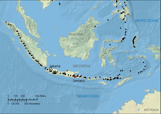 |
Figure 17. Index map of Semeru (red triangle) with respect to other Holocene regional volcanoes (black triangles). Courtesy of CVGHM and VDAP. |
According to reporting by the Center of Volcanology and Geological Hazard Mitigation (CVGHM) and the USGS Volcano Disaster Assistance Program (VDAP), six large explosions between 1981 and 2002 resulted in many fatalities. They noted that since 1995, pyroclastic flows have been restricted to S drainages such as Kali Kembar; however, a small proportion of recent flows have entered the headwaters of Kali Koboan on the SE, which leads to heavily populated areas, including Sumberrejo and Candipuro (figure 18). This report discusses activity between February 2010 (the end of the previous report) and 2 May 2012.
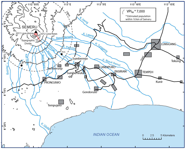 |
Figure 18. 2010 map of Semeru and adjacent area, showing drainage channels from the summit and nearby population centers. Note the location of the 2012 lava flows just S and SE of the volcano. The area around the SE quadrant is heavily populated with a Volcano Population Index (VPI10) of 7,000. In previous eruptions, lahars reached as far as 30 km from the summit. Should similar lahars occur in the future, as many as 150,000 more inhabitants along major drainages could be affected. Based in part on a summary of activity by CVGHM and VDAP. Modified from Siswowidjoyo and others (1997) and Thouret and others (2007); VPI10 was calulated using LandScan 2010. |
On 4 November 2010, CVGHM reported that from August to October 2010 seismic activity at Semeru had increased, and "smoke" and occasional gas plumes rose 400-500 m above the crater. During September incandescent avalanches traveled 400 m SE into the Besuk Kembar drainage on three occasions. Incandescence from the crater was observed in October. Incandescent avalanches traveled 600 m into Besuk Kembar on 2 November. Two days later, they reached 4 km into the Besuk Kembar and Besuk Bang (S) drainages (figure 18). CVGHM noted that the lava dome in the Jonggring Saloko crater was growing. The Alert Level remained at 2 (on a scale of 1-4).
According to the Darwin Volcanic Ash Advisory Centre (VAAC), during 18-19 November 2010, ash plumes rose to an altitude of 4.6 km and drifted 75-110 km N and NW. Sulfur dioxide gas was detected 75 km SW.
According to Volcano Discovery, the group observed 2-3 small-to-medium ash explosions per day during a photo expedition in May 2011, but noted that activity had increased during the past weeks.
In an account posted online by Volcano Discovery on 15 September 2011, the group visited the volcano and noted that an active lava dome was growing inside the crater and that 3-4 eruptions occurred daily. They inferred that the size and frequency of the eruptions had apparently increased in the past days (figure 19).
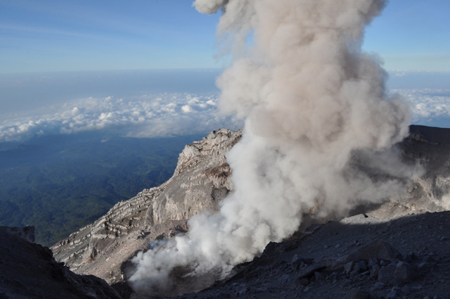 |
Figure 19. Photo of Semeru's crater on 1 September 2011, with a lava dome. Courtesy of Volcano Discovery. |
CVGHM reported that on 29 December 2011, both earthquakes and tremor increased, and dense white-and-gray plumes rose as high as 600 m above the active crater. During January 2012, crater incandescence was observed, and avalanches carried incandescent material 200-400 m away from the crater. According to a 4 January 2012 article in the Jakara Globe, a government official indicated that authorities had closed the trail to the peak of Semeru because of heavy rain and an increased danger of landslides.
On 2 February 2012 a large explosion was reported and incandescent material fell up to 2.5 km from the crater. Tables 20 and 21 indicate the types and numbers of earthquakes and other seismic events reported by CVGHM for February to April 2012. Based on the increased seismic activity and visual observations, CVGHM raised the Alert Level from 2 to 3 on 2 February 2012.
Table 20. Types and numbers of earthquakes and plumes observed at Semeru during February-April 2012. Courtesy of CVGHM.
| Month | Deep | Shallow | Long-distance | Local | Eruptive | Explosive | Harmonic Tremor | Pyroclastic Flow |
| Feb 2012 | 4 | 1 | 61 | -- | 80 | 2336 | 116 | 430 |
| Mar 2012 | 17 | 5 | 60 | 23 | -- | 1665 | 610 | 40 |
| Apr 2012 | 7 | 2 | 44 | -- | -- | 3447 | 66 | 4 |
Table 21. Observed Semeru plumes during February-April 2012. Data from CVGHM. The only other plume noted by the Darwin VAAC between February 2010 and May 2012 was on 18-19 November 2010; this plume was noted in the text. Courtesy of CVGHM.
| Month | Number of observed plumes | Plume height above crater |
| Feb 2012 | 22 | 100-500 m |
| Mar 2012 | 9 | 100-400 m |
| Apr 2012 | 155 | 100-500 m |
CVGHM reported that during 1-29 February 2012 multiple pyroclastic flows from Semeru traveled 500 and 2,500 m into the Besuk Kembar and Besuk Kobokan rivers (on the S flank), respectively. Government officials set up an exclusion zone on the SE flank where pyroclastic flows had occurred.
During 1 February-30 April 2012, dense gray-to-white plumes rose 100-500 m above Jongring Seloko crater and drifted W and N. Incandescence was visible up to 50 m above the crater during 1 February-31 March. Seismicity decreased toward the end of April, although the lava dome grew that month.
According to a news account (People's Daily Online) on 1 March 2012, seismic activity had increased from 28 to 38 tremors per day. According to the news account, Dr. Surono, head of CVGHM, stated that the volcano was erupting daily, emitting ash plumes, and tremor occurred every 15-30 minutes. He also noted that the volcanic dome was increasing in size.
According to Volcano Discovery, an expedition leader visiting Semeru observed frequent explosions every few minutes on 27 March 2012, with many powerful enough to eject glowing bombs that produced small glowing avalanches down the S flank.
According to CVGHM and VDAP, a new lava dome started to extrude in late 2011 directly over a dome formed in 2010. The new dome probably will not completely fill the summit crater because it is being drained by two new lava flows, both flowing SE. The longer of the two lava flows extended about 1.9 km from the summit vent. Pyroclastic flows are being generated by collapse of the steep termini of the lava flows, and their deposits extend to 3.2 km from the summit, i.e. 0.7 km from the front shown in figure 18. In addition, the collapsing lava flow fronts are resulting in high levels of avalanche and rockfall activity. According to CVGHM and VDAP, the closest villages in the highest-risk areas on the S and SE flanks are about 10 km from the summit.
On 2 May 2012 CVGHM lowered the Alert Level to 2, but reminded the public not to approach the crater within a 4-km radius.
Geological Summary. Semeru, the highest volcano on Java, and one of its most active, lies at the southern end of a volcanic massif extending north to the Tengger caldera. The steep-sided volcano, also referred to as Mahameru (Great Mountain), rises above coastal plains to the south. Gunung Semeru was constructed south of the overlapping Ajek-ajek and Jambangan calderas. A line of lake-filled maars was constructed along a N-S trend cutting through the summit, and cinder cones and lava domes occupy the eastern and NE flanks. Summit topography is complicated by the shifting of craters from NW to SE. Frequent 19th and 20th century eruptions were dominated by small-to-moderate explosions from the summit crater, with occasional lava flows and larger explosive eruptions accompanied by pyroclastic flows that have reached the lower flanks of the volcano.
Information Contacts: Center of Volcanology and Geological Hazard Mitigation (CVGHM), Jalan Diponegoro 57, Bandung 40122, Indonesia (URL: http://www.vsi.esdm.go.id/); Volcano Disaster Assistance Program (VDAP), US Geological Survey (USGS), 1300 SE Cardinal Court, Bldg. 10, Suite 100, Vancouver, WA 98683; Darwin Volcanic Ash Advisory Centre (VAAC), Bureau of Meteorology, Northern Territory Regional Office, PO Box 40050, Casuarina, NT 0811, Australia (URL: http://www.bom.gov.au/info/vaac); Jakarta Globe (URL: http://www.thejakartaglobe.com); People’s Daily Online (URL: english.peopledaily.com; Volcano Discovery (URL: http://mobile.volcanodiscovery.com).