Report on Ioto (Japan) — July 2012
Bulletin of the Global Volcanism Network, vol. 37, no. 7 (July 2012)
Managing Editor: Richard Wunderman.
Ioto (Japan) Mud ejections and small phreatic eruptions during early 2012
Please cite this report as:
Global Volcanism Program, 2012. Report on Ioto (Japan) (Wunderman, R., ed.). Bulletin of the Global Volcanism Network, 37:7. Smithsonian Institution. https://doi.org/10.5479/si.GVP.BGVN201207-284120
Ioto
Japan
24.751°N, 141.289°E; summit elev. 169 m
All times are local (unless otherwise noted)
This report first briefly notes an article discussing deformation at Ioto (also called Iwo-jima), an island located within a submerged caldera ~1,200 km S of Tokyo. Ozawa and others (2007) discuss both complex deformation measured during 2006-2007 and the extremely high rate of uplift during the last few hundred years. The rest of this report is devoted to observations by the Japan Meteorological Association (JMA) and other agencies at Ioto during October 2010 to May 2012, including more deformation, small emissions of hot mud and steam, and discolored seawater that suggested a NE flank submarine eruption.
Our previous report on Ioto (Iwo-jima), discussed a submarine eruption off the SE coast that occurred in September 2001, and a small phreatic eruption at Idogahama, a beach on the NW coast of the island, in October 2001 (BGVN 26:09). Ioto is mildly seismically active with many fumaroles and occasional phreatic explosions, but the volcano has not experienced a magmatic eruption in 400 years (Newhall and Dzurisin, 1988; Lowenstern and others, 2006; Yokoyama and Nazzaro, 2002; and Ukawa and others, 2006).
The locations of the major volcanoes of Japan, including the island of Ioto, are shown in figure 5. Figure 6 is a map of Ioto, summarizing its topography and past eruption sites.
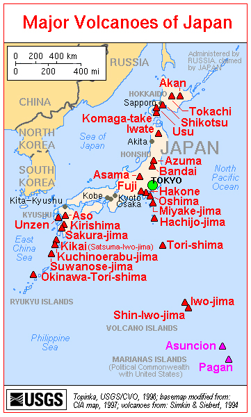 |
Figure 5. A map of the major volcanoes of Japan. Ioto (Iwo-jima) is shown in the lower right. Ioto is about 1,200 km SSE of Tokyo, in the Volcano Islands of the W Pacific Ocean. Courtesy of the U.S. Geological Survey. |
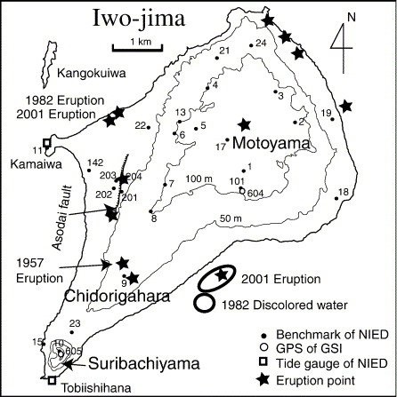 |
Figure 6. Map of Ioto showing topography, major features (including the Asodai fault), and past eruption sites. From Ukawa and others (2006). |
Deformation. Ozawa and others (2007) noted that the overall pattern of deformation seen in the last several hundred years averaged to ~0.25 m of uplift per year, but often exceeded uplift rates of 1 m per year. They plotted uplift and subsidence during January 2006-late 2007 from satellite radar interferometry. Concluding that the deformation pattern is very complicated both spatially and temporally, the authors noted that "In August of 2006, subsidence which had continued from 2003 rapidly changed to uplift, and an increase of seismicity was also observed simultaneously." They divided the uplift during August 2006-late 2007 into 3 stages. The authors used gravity and magnetic data to constrain the shape of the shallow intruding magma under the island's main edifice (Motoyama, also spelled Moto-yama) centered in the bulbous NE portion of the island (figure 6). They described the intruding magma body as having a funnel shape, narrowing towards the bottom and centered about the main topographic high. The authors' modeling suggested that the block of material trapped within the funnel was variously displaced during each of the deformation stages, shifting the block depending on where the magma pooled.
JMA reports. The following material summarizes activity from October 2010 to May 2012, based on monthly volcanic activity reports from JMA. JMA reports on Ioto between November 2001 and September 2010 are not available in English; translations into English resumed in October 2010.
In October 2010, Japan's National Research Institute for Earth Science and Disaster Prevention (NIED) reported that seismicity remained at a low level. GPS observations by the Geospatial Information Authority of Japan (GSI) indicated that an episode of uplift that had ceased around October 2009 resumed in May 2010. N-S baseline displacement (extension) accelerated during late September-early October 2010, accompanied by an eastward deformation in the central part of the island. The uplift slowed after mid-November 2010. This upheaval followed one that occurred during August 2006-October 2009.
During 29-30 January 2011, aerial observations were conducted in cooperation with the Japan Maritime Self-Defense Force (JMSDF). No change in the distribution of thermal anomalies or emissions was detected since the last observation in July 2010.
According to NIED and GSI, both shallow seismicity and the rate of uplift at Ioto increased in February 2011 and continued through at least January 2012. GPS measurements showed a rapid southward displacement at the S part of island. Moreover, between 26 August and 2 September 2011, a local westward displacement was observed SW and SE of Motoyama.
A field survey during 16-18 November 2011 revealed that the water level in Asodai crater (along the fault of the same name, figure 6) had risen compared with the last observation during 29-30 January 2011. The temperature of the muddy water at the bottom of the pit was estimated to be ~100°C, the same as that observed in January 2011. Associated discharges reached a maximum height of 20 m above the crater. No change in the distribution of thermal anomalies or emissions was detected since the last observation in January 2011.
On 10 February 2012, JMSDF reported a mud ejection at an old crater (another depression along the Asodai fault, a spot sometimes called "Million Dollar Hole"). According to field surveys on 14 and 15 February, three major ejection sites were aligned in the N-S direction, the deepest being about 13 m. Mud was ejected to distances of up to 100 m NE of the main vent. No seismicity was observed to be associated with this event, but JMA believed a very small phreatic explosion probably occurred during early February. The maximum temperature of the mud was 96.6°C. Another mud ejection occurred on 7 March in the same area, and mud was ejected up to 60 m WNW. Ash emissions also rose from Asodai, but not from Idogahama.
During another field survey from 7 to 9 March 2012, further mud ejections were noted from the same area as the previous events on the island's W side. In addition, a very small phreatic eruption was noted, with tremor (90-minute duration) and intermittent ejections of steam plumes, mud, and small rocks. Emissions rose 20 m above the crater, and small amounts of ash rose more than 10 m and scattered within 20 m in every direction. During that time, the water level in Asodai crater was higher than that observed during the 16-18 November observation.
During 5-6 April 2012, volcanic tremor and intermittent earthquakes were recorded, and two apparently very small phreatic eruptions were reported. This was accompanied by intermittent noises and emissions at the old crater to the W of the island. According to GSI, ground deformation and seismic activity were greater than usual during 27-28 April, but both subsided after 4 May.
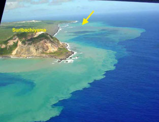
During 29-30 April, the ocean NE of the island was discolored, suggesting an offshore underwater eruption. An aerial observation conducted by the Japan Coast Guard (JCG) on 16 May revealed that discoloration persisted, but in smaller areas. On the N part of the island, steam plumes rose to heights of up to 10 m on 30 April.
During May 2012, ground deformation was almost static. Seismic activity diminished, and no volcanic tremors were observed. Based on camera monitoring, emissions from Asodai crater were low, and no emissions were noted in Idogahama.
References. Lowenstern, J.B., Smith, R.B., and Hill, D.P., 2006, Monitoring super-volcanoes: geophysical and geochemical signals at Yellowstone and other large caldera systems, Phil. Trans. R. Soc. A 364, p. 2055-2072.
Yokoyama, I., and Nazzaro, A., 2002, Anomalous crustal movements with low seismic efficiency-Campi Flegrei, Italy and some examples in Japan, Annals of Geophysics, v. 45, no. 6, p. 709-722.
Newhall, C.G., and Dzurisin, D., 1988, Historical unrest at large calderas of the world, U.S. Geological Survey Bulletin 1855: 1108 p, 2 vol, pgs. 509-520.
Ukawa, M., Fujita, E., Ueda, H., Kumagai, T., Nakajima, H., and Morita, H., 2006, Long-term geodetic measurements of large scale deformation at Iwo-jima caldera, Japan, J. of Volcanology and Geothermal Research, v. 150, p. 98-118.
Ozawa, T., Ueda, H., Ukawa, M., and Miyazaki, S., 2007, Temporal change in crustal deformation related to volcanic activity of Iwo-jima observed by PALSAR/InSAR, Proceedings of the First Joint PI Symposium of ALOS, Data Nodes for ALOS Science Program (DIS 10).
Geological Summary. Ioto, in the Volcano Islands of Japan, lies within a 9-km-wide submarine caldera. The volcano is also known as Ogasawara-Iojima to distinguish it from several other "Sulfur Island" volcanoes in Japan. The triangular, low-elevation, 8-km-long island narrows toward its SW tip and has produced trachyandesitic and trachytic rocks that are more alkalic than those of other volcanoes in this arc. The island has undergone uplift for at least the past 700 years, accompanying resurgent doming of the caldera; a shoreline landed upon by Captain Cook's surveying crew in 1779 is now 40 m above sea level. The Motoyama plateau on the NE half of the island consists of submarine tuffs overlain by coral deposits and forms the island's high point. Many fumaroles are oriented along a NE-SW zone cutting through Motoyama. Numerous recorded phreatic eruptions, many from vents on the W and NW sides of the island, have accompanied the uplift.
Information Contacts: Japan Meteorological Agency (JMA), Otemachi, 1-3-4, Chiyoda-ku Tokyo 100-8122, Japan (URL: http://www.jma.go.jp/); Japan’s National Research Institute for Earth Science and Disaster Prevention (NIED), 3-1, Tennodai, Tsukuba, Ibaraki, 305-0006, Japan (URL: http://www.bosai.go.jp/e/); Geospatial Information Authority of Japan (GSI) (URL: http://www.gsi.go.jp/ENGLISH/); Japan Maritime Self-Defense Force (JMSDF) (URL: http://www.mod.go.jp/msdf/formal/english/index.html); Japan Coast Guard (JCG) (URL: http://www.kaiho.mlit.go.jp/e/index_e.htm).