Report on Telica (Nicaragua) — February 2013

Bulletin of the Global Volcanism Network, vol. 38, no. 2 (February 2013)
Managing Editor: Richard Wunderman.
Telica (Nicaragua) Degassing continues in 2012; increased micro-earthquake activity in March 2013
Please cite this report as:
Global Volcanism Program, 2013. Report on Telica (Nicaragua) (Wunderman, R., ed.). Bulletin of the Global Volcanism Network, 38:2. Smithsonian Institution. https://doi.org/10.5479/si.GVP.BGVN201302-344040
Telica
Nicaragua
12.606°N, 86.84°W; summit elev. 1036 m
All times are local (unless otherwise noted)
Degassing that followed the May 2011 explosive eruption of Telica (figure 29; see also BGVN 36:11) continued through 2012 and into 2013. The following information summarizes observations by the Nicaraguan Institute of Territorial Studies (INETER) for 2012 and through March 2013.
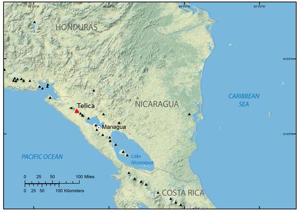 |
Figure 29. A location map of Telica, Nicaragua, in Central America. Telica (red triangle) is located ~105 km NW of the capitol, Managua. It last erupted in May 2011 (BGVN 36:11), but no major damage was reported. Gases emitted by Telica normally affect communities in the nearby provinces of Leon and Chinandega. Small black triangles in the figure depict other known Holocene volcanos in the region. Courtesy of USGS. |
INETER issues a monthly bulletin, Boletín mensual Sismos y Volcanes de Nicaragua (Newsletter, Earthquakes and Volcanoes in Nicaragua), reporting on monitoring of Nicaraguan volcanoes including San Cristóbal, Telica, Cerro Negro, Momotombo, Masaya, and Concepcion (figure 30). In the Boletín, INETER presents monitoring data for Telica crater and adjacent fumarol temperatures, seismic activity, and sulfur dioxide (SO2) fluxes. In addition, visual observations are made during periodic field trips. Generally, the time difference between the arrival of P (primary) and S (secondary) waves from local earthquakes ranges from 0.5 to 2 sec, suggesting a source depth of 4 to 10 km.
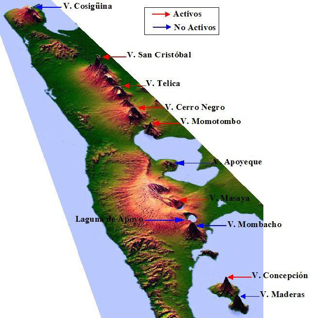 |
Figure 30. An oblique view of a schematic map of Nicaragua with high vertical exaggeration highlights the locations of Nicaraguan volcanoes. Courtesy of INETER. |
As an example of normal ongoing activity at Telica, INETER reported that during 10-11 September 2012, 'jet' sounds were heard from the volcano, and two incandescent fumaroles were observed, along with gas-and-steam plumes rising 100-200 m above the crater. On 11 September two small explosions occurred in the crater. During 12-14 and 17 September gas plumes rose 30-150 m and incandescence from the crater was observed. Gas measurements on 14 and 17 September showed normal levels of SO2 flux.
2012 Sulfur dioxide flux. Average daily SO2 flux measurements made using the Mini-DOAS (differential optical absorption spectroscopy) mobile technique in 2012 were 303 metric tons per day in April, 627 metric tons per day in June, 377 metric tons per day in August, and 130 metric tons per day in October.
2012 Seismic Events. INETER has developed some novel ways for grouping seismic events at Telica. The types of seismic events monitored at Telica and activity during 2012 are shown in tables 5 and 6, respectively.
Table 5. Types of seismic activity monitored at Telica volcano, with characteristics as recorded and interpreted during 2012. Courtesy of Virginia Tenorio, INETER.
| Activity type nomenclature (abbreviations) | Frequency range/peak (Hz) | Duration | Possible explanation for 2012 events |
| Long period (LP) | 1.0-4.5/4.0 | 20-40 sec | Magma movement at depth 6-10 km |
| Tremor | 5.0-7.0 | short | Degassing and magma movement |
| Volcano-tectonic (VT; VTA+VTB) | 10.0-20.0+/12 | 1+ min | Rupture of rock at depth 6-10 km |
| Double earthquake (S.DO) | 4.0-7.0/4.0 and 7.0 | 40-60 sec | Fracture of brittle soil followed by magma displacement |
| Gas explosion (E.G) | 4.0-10.0 Hz | 1-2 min | Release of gas in volcano duct |
| Swarms of seismic events (trenes de sismos) (TS) | 5.0-7.0 Hz | 1-3 min | Breaking rocks combined with LP-type events (average of 10 events per swarm) |
| Degasification signal (S.D) | 5.0-10.0 | 1 min | -- |
Table 6. Total volcano-seismic events and numbers of various types of events (see table 5 for descriptions) that were reported at Telica during 2012; percentages indicate the contribution of each type of event to the total recorded number of events during that month. Courtesy of INETER.
| Activity type | 18-31 March | April | May | June | July |
| Total events | 1,986 | 3,222 | 3,544 | 5,754 | 4,112 |
| LP | 535 (27%) | 953 (30%) | 1,077 (30%) | 827 (14%) | 332 (8%) |
| S.DO | 658 (33%) | 638 (20%) | 635 (18%) | -- | -- |
| Tremor | 0 (0%) | 72 (2%) | 78 (2%) | 0 (0%) | 125 (3%) |
| E.G | 625 (32%) | 609 (19%) | 686 (19%) | -- | -- |
| VT (VTA + VTB) | 168 (8%) | 299 (9%) | 315 (9%) | 2,418 (42%) | 997 (24%) |
| S.D | -- | 651 (20%) | 753 (21%) | -- | -- |
| TS | -- | -- | -- | 2,519 (44%) | 2,658 (65%) |
2012 Temperature measurements. Figure 31 shows INETER staff members measuring crater and fumarole vent temperatures at Telica; temperatures are measured approximately once per month (figure 32). Temperatures measured during 2012 at the 4 fumaroles (figure 33), vents located E and outside of Telica crater, ranged between 52° and 79°C.
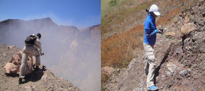 |
Figure 31. INETER staff measuring temparatures at the Telica crater using a thermal imaging camera (left) and one of the fumarole vents using an IR thermometer (right). Courtesy of INETER. |
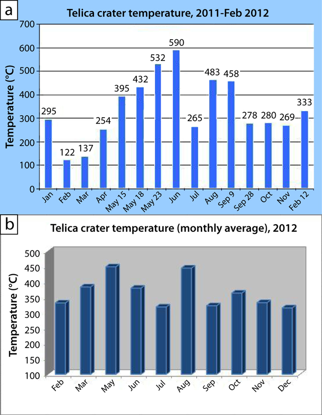 |
Figure 32. (a) Maximum monthly temperatures for Telica crater during January 2011-February 2012, and (b) average monthly temperatures during 2012. Courtesy of INETER. |
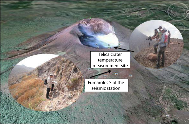 |
Figure 33. A W looking Google Earth view of Telica showing the approximate location of the fumarole vents E of Telica crater (lower arrow) and the location of temperature measurements in the crater (upper arrow). Courtesy of INETER. |
2013 activity. The Costa Rica News reported on 24 March 2013 that Virginia Tenorio of INETER announced that Telica was experiencing increased micro-earthquakes. According to the INETER report, dozens of micro-earthquakes had occurred per day since 17 March. The increase continued to at least 24 March; 20 earthquakes occurred on 22 March, but only one reached as high as M 2.1. Tenorio was reported to state that, although earthquakes were located within the volcano's structure, an imminent eruption was not indicated. She further stated that while some changes may occur in the magmatic system and in the expulsion of gases, conditions were stable. Local observers reported elevated vapor and gas emissions associated with the spike in seismicity and incandescence in a fissure at the bottom of the active crater. Since 21 March 2013, the member institutions of the National System for Prevention, Mitigation and Attention to Disasters (SINAPRED), have been ordered to monitor Telica's activity and keep it under close observation.
Geological Summary. Telica, one of Nicaragua's most active volcanoes, has erupted frequently since the beginning of the Spanish era. This volcano group consists of several interlocking cones and vents with a general NW alignment. Sixteenth-century eruptions were reported at symmetrical Santa Clara volcano at the SW end of the group. However, its eroded and breached crater has been covered by forests throughout historical time, and these eruptions may have originated from Telica, whose upper slopes in contrast are unvegetated. The steep-sided cone of Telica is truncated by a 700-m-wide double crater; the southern crater, the source of recent eruptions, is 120 m deep. El Liston, immediately E, has several nested craters. The fumaroles and boiling mudpots of Hervideros de San Jacinto, SE of Telica, form a prominent geothermal area frequented by tourists, and geothermal exploration has occurred nearby.
Information Contacts: Virginia Tenorio, Instituto Nicaragüense de Estudios Territoriales (INETER), Apartado Postal 2110, Managua, Nicaragua (URL: http://www.ineter.gob.ni); Costa Rica News, San Jose, Costa Rica (URL: http://thecostaricanews.com); Sistema Nacional para la Prevención, Mitigación y Atención de Desastres (SINAPRED), Managua, Nicaragua (URL: http://www.sinapred.gob.ni/); MODVOLC, Hawai'i Institute of Geophysics and Planetology (HIGP) Thermal Alerts System, School of Ocean and Earth Science and Technology (SOEST), Univ. of Hawai'i, 2525 Correa Road, Honolulu, HI 96822, USA (URL: http://modis.higp.hawaii.edu/).