Report on Manam (Papua New Guinea) — June 2013

Bulletin of the Global Volcanism Network, vol. 38, no. 6 (June 2013)
Managing Editor: Richard Wunderman.
Manam (Papua New Guinea) Sporadic heightened activity, 2011-2013; new vents
Please cite this report as:
Global Volcanism Program, 2013. Report on Manam (Papua New Guinea) (Wunderman, R., ed.). Bulletin of the Global Volcanism Network, 38:6. Smithsonian Institution. https://doi.org/10.5479/si.GVP.BGVN201306-251020
Manam
Papua New Guinea
4.08°S, 145.037°E; summit elev. 1807 m
All times are local (unless otherwise noted)
Our last report on Manan (BGVN 36:06; figure 29) discussed field observations through 11 January 2011. The following summarizes available Rabaul Volcano Observatory (RVO) reports issued since that time through May 2013. Pyroclastic flows took place during the reporting interval, specifically four times on 16 June 2012, and another four times on 30 July 2012, all of which traveled down the SE valley. No injuries were reported. In addition there were lava fountains, several lava flows, and some cases of sustained emissions lasting hours. Occasional ash plumes triggered the Darwin Volcanic Ash Advisory Centre (Darwin VAAC) to issue notices. Some ash plumes drifted over 200 km. Loud noises, rumbling, tephra ejected above or outside the confines of the crater, and night glow were common observations.
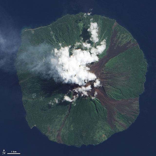 |
Figure 29. This ALI satellite photo was taken of Manam on [9 June 2009]. Courtesy of NASA Earth Observatory. |
2011 activity. During 1-19 August 2011, RVO reported Manam's summit area was obscured by weather clouds on most days. When the summit was clear to viewers on the mainland, 15-20 km away from Manam, both vents emitted white vapor plumes. Main Crater produced light-gray ash clouds during 13 and 17-18 August, and bright, steady incandescence was visible on most clear nights. August seismicity was dominated by volcanic tremor, but discrete high-frequency volcano-tectonic earthquakes were also recorded which, RVO noted, are not very common for Manam. An electronic tiltmeter located ~4 km SW from the summit craters continued to show inflation.
Based on analysis of satellite imagery, the Darwin VAAC reported a series of ash plumes which, during 18-21 August, rose to altitudes of 1.8-2.1 km and drifted 45-90 km NW and W. The VAAC next reported that on 18 October, ash plumes rose to 3.7 km altitude and drifted 150-170 km NW. During 19-21 October ash plumes rose to an altitude of 3.7 km and drifted 150-220 km W. For 11 November 2011, using both satellite imagery and a pilot observation, the VAAC reported an ash plume to an altitude of 3 km drifting up to ~90 km NE.
Activity continued in December 2011. Seismicity was assessed by Real-time Seismic Amplitude Measurements (RSAM) and varied at high levels between 200-350 RSAM. Both craters produced ash and lava fragments. The ash clouds rose to several hundred meters above the vents. Both vents often glowed at night, and expelled glowing fragments. Brown and grey ash was deposited in areas down wind. There were reports of a possible lava flow from the Southern Crater, with the 'V' shaped channel created by the 2005 blast being filled up.
2012 activity. RVO reported continued activity during January 2012. White vapor and grey-to-black ash emissions rising less than 200 m were observed from both craters throughout the month, sometimes with accompanying weak incandescent projections. From the Southern Crater, more sustained emissions on the evening of 20 January occurred with mainly black ash up to 400 m, trending to the SE. At that time low-energy projections observed at 3-4 minute intervals fell back inside the crater. Main Crater produced a bright steady glow and released thick white vapor with a strong blue tinge. On 23 January observers noted that there were possibly three vents emitting columns of vapor and ash. Seismicity during this time remained moderate to high, with a variable RSAM of 200-350.
RVO next reported mainly mild activity at Southern Crater during the first two weeks of May 2012. Diffuse white and blue vapor emerged during 5-6 and 13-14 May, and gray and gray-brown ash clouds were observed on 7, 9, and 12 May. Observers noted incandescence on the nights of 6, 8, 10-11, and 13-14 May, and glowing tephra occasionally falling outside of the crater.
Activity increased on 16 May 2012. Ash cloud colors changed from gray and gray-brown to gray and black. On 27 and 30 May Strombolian emissions occurred and, for periods lasting 1-2 hours, continuously ejected incandescent tephra. On 30 May two vents at the Southern Crater produced lava fountains. Ash plumes rose 100-400 m above the crater and drifted NW. Most of the tephra fell back into the crater, but some was channeled into the SE and SW valleys. Emissions from Main Crater were milder and characterized by white plumes and gray to gray-brown ash plumes noted during 6, 10-11, 13, 26, 28-29, and 31 May. Ash fell on the NW part of the island.
Seismicity during May 2012 maintained a moderate to moderately-high level and was associated with discrete low-frequency earthquakes and low-level, sporadic volcanic tremor in the background occurring during 1-9 May. Daily low frequency totals ranged between 880 and 970. The steady increase in RSAM observed in April continued until about 16 May, and fluctuated in an upward trend thereafter. The fluctuations reflected phases or episodes of low and moderate activity. The highest RSAM of 500 was reached on the 30th. After 30 May RSAM declined again to reach 350 by the end of May. Around this time tremor became dominant and overshadowed the discrete events, making it difficult to conduct event counts. The electronic tiltmeter (located 4 km SW) continued to show gentle uptilt towards the summit.
RVO reported low to moderate activity during 1-15 June 2012. Emissions consisted of gray and sometimes black ash clouds that rose from the crater on most days. Plumes drifted SE on 2 June and NW during 6-15 June. Ash fell in areas downwind between Yassa (WSW) and Baliau (NNW), and Warisi (ESE). Incandescent material was also ejected from the crater.
Pyroclastic flows on 16 June 2012 (at 0700, 0725, 0727, and 0729) all channelled into the SE valley. The last pyroclastic flow was perhaps the largest. It reached the lowest elevation, 300-400 m above sea level, but came to rest far from populated areas. Ash plumes from the pyroclastic flows rose ~1,000 m and drifted WSW and WNW. Small amounts of ash fell in villages between Dugulava (on the SW side of the island) and Yassa. Fine ash also fell in downwind areas on the mainland, including the Bogia government station (25 km SSW, on the mainland). Emissions from Main Crater were milder and mostly characterized by white and bluish plumes. Light gray plumes were noted during 2 and 8-9 June.
Ash fell in the NW part of the island. Weaker emissions occurred on 17 June, mostly consisting of steam with occasional ash. During 18-30 June gray and occasionally black ash clouds rose 100-150 m above the crater and drifted mainly NW. Incandescent tephra was ejected from the crater on most nights. Activity during 28-29 June was almost sub-Plinian. Emissions from Main Crater were milder and mostly characterized by white and bluish plumes. Gray ash plumes were emitted during 18, 23, 26-27, and 29 June. Incandescence from the crater was visible during 18, 20-22, and 24 June. Ash again fell in the NW part of the island. Seismic recording ceased during 12-27 June 2012 due to equipment failure at Bogia apparently caused by a lightning strike. During the period of data recording, seismicity remained at moderate to moderately high level, dominated by sub-continuous to continuous volcanic tremor. RSAM fluctuated between 250 and 550. High peaks in the RSAM between 4 and 10 June were associated with moderate to strong phases of eruptive activity described above. The electronic tiltmeter was generally stable during reporting period, but the long term trend showed slow inflation towards the summit area. When seismic recording resumed on 28 June 2012, the level of seismicity had risen slightly: RSAM 400-600. The high RSAM values corresponded to some of the moderate summit activity reported above. Seismicity was dominated by sub-continuous to continuous volcanic tremor. Around this time, the electronic tiltmeter remained out of service.
During the first half of June RVO recommended authorities declare a Stage 2 alert level. The level remained at Stage 2 for the remainder of June 2012. In their next available report, RVO noted that activity increased slightly during 15-31 July, except during 18-20 July when ash emissions decreased. During most of the reporting period, when visibility was clear, gray-to-sometimes-black ash plumes were observed rising 300-700 m above the crater discharging from two vents. The plumes mainly drifted NW, mainly affecting villages between Yassa and Kuluguma. Rumbling was heard on 25 July from Bogia. Bright glow visible at night was attributed to ejected incandescent tephra. Sub-Plinian activity occurred on most nights during 21-31 July. Small lava flows descended the SW flank.
Four pyroclastic flows traveled down the SE flank on 30 July (at 0638, 0640, during 1200-1300, and at 1428). The first event was the largest, and generated an ash plume that rose 1.8 km above the crater and drifted NW. As before, all four flows were again channeled into the SE valley. Emissions from Main Crater were milder and mostly characterized by white and bluish plumes, and occasional gray ash plumes. The Alert Level remained at Stage 2. Seismicity fluctuated, and was very high during 16-17 July 2012, dominated by sub-continuous to continuous volcanic tremors. RSAM ranged between 500 and 700. It declined thereafter to 150-300 units between 18 and 20 July before increasing again rapidly to 700 on the 21st. The reduced seismicity between 18 and 20 coincided with the reduced summit activity. Seismicity remained at a very high level (700 RSAM units) for the next few days before declining again to another low (300 RSAM units) on 26 July. There was one more phase of high activity (700 RSAM units) between 28 - 30 July, before RSAM became steady at 450 until the end of the month. The electronic tiltmeter remained out of service.
2013 activity. RVO reported that dark gray ash plumes were occasionally emitted from Manam's Southern Crater during 8-12 January. At about 1000 on 12 January a sub-Plinian eruption generated ash plumes that rose 1.4-1.5 km above the crater; activity peaked between 1200 and 1300. The ash plumes drifted SW, S, and SE, producing ashfall on the island in areas downwind and light ashfall in Bogia (23 km SSW). Activity decreased after 1600, and ash plumes rose only 500 m above the crater. At night ejected incandescent material was observed. Ejected material and ashfall was deposited in the SE and SW valleys. Ash plumes drifted S during 13-14 January. White vapor plumes rose from Main Crater during the reporting period. Based on observations of satellite imagery and wind data analyses, the Darwin VAAC reported that an ash plume rose to an altitude of 3 km a.s.l. on 28 January and drifted 22 km E. The next day an ash plume drifted 93 km NE, and then later another ash plume drifted 55 km NE at an altitude of 4.3 km a.s.l.
Seismicity was low on 8 January with RSAM value was 80. But beginning on 9 January it started to gradually increase, reaching a moderate level early on the 11th. RSAM had by then reached 200. Seismicity continued to increase, as RSAM reached 550 between 1000 and 1100, which coincided with the commencement of the small sub-Plinian eruption reported above. RSAM reached a peak of 620 at about 2300 on 12 January before it subsided to about 320 at 0500 on 13 January. RSAM fluctuated between 230 and 600 until the end of the reporting period. Seismicity was characterized by frequent small low frequency earthquakes during low to moderate seismicity and by sub-continuous to continuous volcanic tremors during high seismicity. Data from the electronic tiltmeter did not show any significant changes.
Based on observations of satellite imagery and wind data analyses, the Darwin VAAC reported that an ash plume rose to an altitude of 10.1 km a.s.l. on 12 February and drifted 55 km SW. On 16 February an ash plume rose to an altitude of 3.4 km a.s.l. and drifted over 35 km NW.
RVO reported that on 1 March Main and Southern Craters emitted small amounts of diffuse white vapor; the craters were either partially or totally obscured by meteorological cloud cover. On 4 and 7 March intermittent gray ash plumes rose 300 m, above the cloud cover. RSAM values remained at a near-background level of 120. A gradual increase began on 2 March, reaching a peak of about 350 on 6 March before declining again to 300 on 7 March. The increase in RSAM on the 6 March was attributed to a increase in the number and size of low frequency earthquakes and occasional sub-continuous volcanic tremors. Ground deformation data from the electronic tiltmeter fluctuated within a steady trend.
Based on analysis of satellite images, pilot observations, and wind data analyses, the VAAC reported that on 14 March an ash plume rose to altitudes of 6.1-7.6 km a.s.l. and drifted 110-150 km ESE.
Based on analysis of satellite imagery (MT Sat) and wind data analyses, the Darwin VAAC reported that on 10-11 April an ash plume rose to altitudes of ~ 2 km and and drifted 75 km W. RVO reported that Manam's high level of activity continued on 15 April. Ash plumes rose 500 m above the crater. A loud explosion was heard at 0804. At about 1950 dense ash plumes rose 2 km and drifted SW. At night loud jet-like noises were reported by residents in Bogia. Lava was observed flowing from a new vent on the headwall of SW valley during a brief clear period from 1800 to 1850. Ash and scoria fell in most villages between Dugulava, on the SW side of the island, and Kuluguma on the NW side. Similar activity continued during the first half of 16 April, including a small pyroclastic flow that occurred around 1359 that was channeled into SE valley. Thereafter, the activity was characterized by gentle light gray ash emissions until 20 April.
During the high activity between 13 and 16 April, the formation of two new sub-terminal vents was reported. The exact timing is unclear due to occasional cloud cover around the summit area. The first vent probably formed on 13 April on the side of the headwall of SW valley. The vent was seen releasing lava effusively into SW valley. The second vent formed sometime during the evening of the 15 April E of Southern Crater in SE valley at an approximately similar elevation as those formed in mid 2012.
Seismicity, reflecting activity at the summit, was high on 15 April with RSAM readings fluctuating ~ 700. It declined slowly from 16 April and, as of the 18 April, it reached a moderate level with RSAM of 370, then declined again to 220. The down-tilt or deflation towards the summit area stopped around 15 April. Subsequently, information from the electronic tiltmeter was stable.
RVO reported that on 23 April dense white vapor plumes occasionally rose from Southern Crater. During 25-28 April ash clouds rose from the new sub-terminal vent E of Southern Crater inside the SE valley. The ash clouds rose 600 m and drifted NW. Loud booming noises were heard each day; however, between 0700 and 1900 on 27 April the noises became more frequent, louder, and explosive in nature, and were heard at Bogia. Seismicity remained high and swung around in the latter part of 25 April and increased steadily until it reached peak activity on the 28 April, before dropping slightly. Corresponding RSAM values increased from 220 on the 25 April, to 650 on the 28 April, and thereafter dropped to 500. Seismicity was characterized by small to moderate low frequency earthquakes.
Information from the electronic tiltmeter did not show any significant movements. RVO reported that during 29 April-16 May activity at Manam was low, characterized by white and occasionally blue vapor plumes rising from Southern Crater. White vapor plumes also rose from Main Crater. Seismicity fluctuated at high level between 29 April and 1 May; RSAM ranged between 500-700. After 1 May it started to decline, reaching a low level on 4 May and remaining low for the remainder of the reporting period. The corresponding RSAM at low level ranged between 50 and 100. RVO reminded people to stay away from the four main radial valleys, and especially the SE and SW ones, because most products from the activity at Southern Crater were channeled into these two valleys. No significant surface deformation was detected by the electronic tiltmeter.
Digital book in press. A new academic, digital book has sections that clearly relate to Manam (Johnson, 2013, in press). From the table of contents, those sections are (9) Tony Taylor and an Eruption Time Cluster: 1951-1966, Evacuation of Manam and the 1956-66 Eruptions and (14) Eruptions of the Early Twenty-first Century: 1998-2008. Manam, 2004-5: Abandoning a Volcanic Island?
Reference. Johnson, RW, (2013, in press), Fire Mountains of the Islands: A History of Volcanic Eruptions and Disaster Management in Papua New Guinea and the Solomon Islands, Australian National University E-press (ANU E Press (URL: http://epress.anu.edu.au/).
Geological Summary. The 10-km-wide island of Manam, lying 13 km off the northern coast of mainland Papua New Guinea, is one of the country's most active volcanoes. Four large radial valleys extend from the unvegetated summit of the conical basaltic-andesitic stratovolcano to its lower flanks. These valleys channel lava flows and pyroclastic avalanches that have sometimes reached the coast. Five small satellitic centers are located near the island's shoreline on the northern, southern, and western sides. Two summit craters are present; both are active, although most observed eruptions have originated from the southern crater, concentrating eruptive products during much of the past century into the SE valley. Frequent eruptions, typically of mild-to-moderate scale, have been recorded since 1616. Occasional larger eruptions have produced pyroclastic flows and lava flows that reached flat-lying coastal areas and entered the sea, sometimes impacting populated areas.
Information Contacts: Rabaul Volcano Observatory (RVO), PO Box 386, Rabaul, Papua New Guinea; Darwin Volcanic Ash Advisory Centre (VAAC) (URL: http://www.bom.gov.au/info/vaac/).