Report on Rabaul (Papua New Guinea) — October 2013

Bulletin of the Global Volcanism Network, vol. 38, no. 10 (October 2013)
Managing Editor: Richard Wunderman.
Rabaul (Papua New Guinea) Variable but often modest eruptions during mid-2011 through 2013
Please cite this report as:
Global Volcanism Program, 2013. Report on Rabaul (Papua New Guinea) (Wunderman, R., ed.). Bulletin of the Global Volcanism Network, 38:10. Smithsonian Institution. https://doi.org/10.5479/si.GVP.BGVN201310-252140
Rabaul
Papua New Guinea
4.2459°S, 152.1937°E; summit elev. 688 m
All times are local (unless otherwise noted)
The last Bulletin report on Rabaul Caldera (BGVN 36:07) recorded dozens of explosions in the first week of August 2011. The explosions produced ash-rich clouds that drifted NW and deposited ash in areas from Rabaul Town (3-5 km NW) to Nonga Village (10 km NW) (figure 57). This report covers activity from the end of August 2011 to December 2013, using data primarily compiled from the Rabaul Volcano Observatory (RVO) and the Darwin Volcanic Ash Advisory Center (VAAC). During this time, hundreds of small earthquakes were detected, almost all of which occurred congruently with ash emissions or explosions. One notable development occurred in July 2013, when a new lava dome formed on Tavurvur in the middle of a long period of eruptive activity running from April to September of the same year. Shortly after the dome's formation, strong venting of ash at Tavurvur gave way to explosions on 10 July that continued until 5 September, 2013. A second period of explosive activity began on 13 November, 2013, and terminated at the end of November.
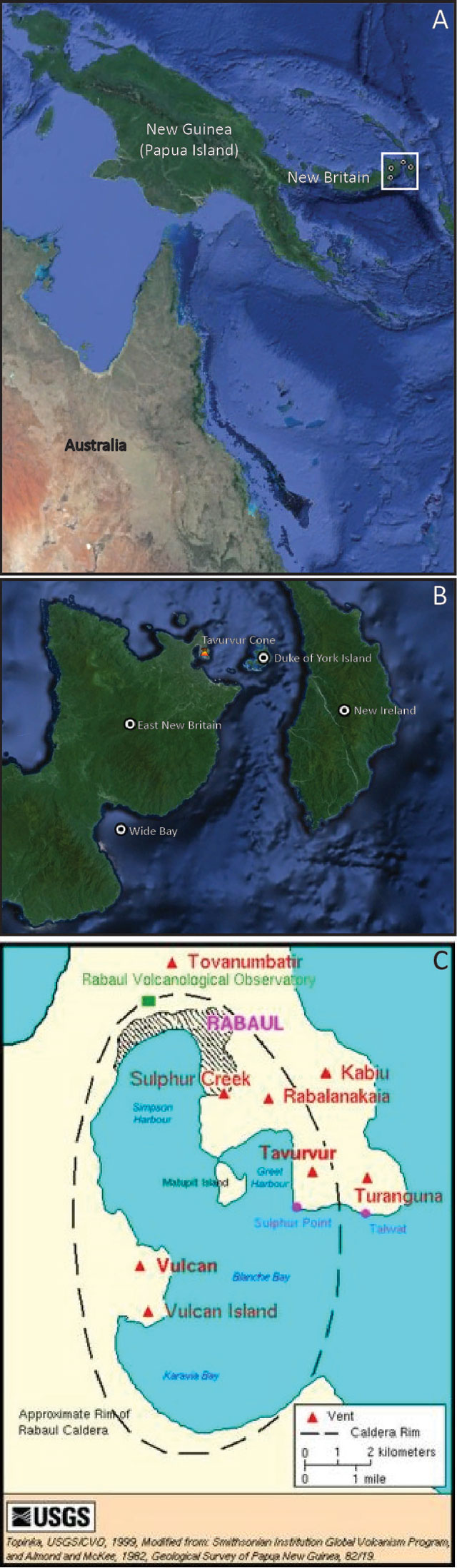 |
Figure 57. Location maps of Rabaul and Tavurvur Cone (a and b). White boxes in a and b zoom to show maps b and c, respectively. Maps derived from Google Earth Landsat images and modified to show regional reference points in relation to Rabaul's Tavurvur Cone. (c) map of Rabaul caldera derived from work by Almond and McKee and prepared by Lyn Topinka (US Geological Survey 1998). |
August 2011 to November 2012. Rabaul Caldera was generally tranquil from 12 August 2011 to November 2012. During this time, only emissions of white vapor were seen rising from the cone, which became denser with the rain and humidity or periods of cool temperatures. Seismicity was low although several high frequency earthquakes NE of Tavurvur were recorded on 6 June 2012. GPS instruments recorded at least 2 cm of inflation (greater than the long-term decadal trend in inflation) and sub-continuous tremor was recorded by four local seismic stations 17-20 September 2011. Diffuse SO2 emissions recorded in late November 2012.
January and February 2013. At 2128 on 19 January 2013, Rabaul town residents and volcanologists at RVO heard loud rumbling and roaring noises from Tavurvur, marking the beginning of a period of activity that lasted until 2 February 2013 (table 12). RVO determined on the morning of 20 January that small discrete explosions had produced ash plumes during the night. Those plumes reached a maximum height of 500 m above the crater, and the prevailing winds pushed them E and SE.
Table 12.Maximum height above the crater, date, direction, and color for plumes from Tavurvur Cone from 19 January, 2013 to 7 February 2013. Seismicity during some of the events is also described. Courtesy of RVO.
| Date | Plume Height (m) | Direction | Color | Seismicity |
|---|---|---|---|---|
| 1/19 | 500 | E, SE | N/A | N/A |
| 1/20 | 200 | E, SE | Light Gray | N/A |
| 1/22 | 200 | S, SSE | Gray | N/A |
| 1/22 (2148) | 2000 | SE, ESE | Gray | N/A |
| 1/23 | 2000 | SE | Light Gray | Numerous, associated with ash emissions |
| 1/24 | 1000 | E, ESE | Light Gray | Numerous, associated with volcanic degassing |
| 1/25 | 700 | E, ESE | Light Gray | Low, associated with ash emissions |
| 1/26 | 500 | ESE | Gray | Low, associated with ash emissions |
| 1/27 | 500 | ESE | White and Light Gray | Low, associated with ash emissions |
| 1/28 | 500 | ESE | White and Light Gray | Low |
| 1/29 | 500 | E, ESE | Light Gray | Low |
| 1/30 | 500 | ESE | Light Gray | Low |
| 2/1 | 500 | E, ESE | Light Gray | Low |
| 2/2 | 500 | E, ESE | Light Gray | Low |
| 2/3 | 2000 | E, NE | Dark Gray | Low, associated with ash emissions |
| 2/4 | 2000 | E, SE | Light Gray | Low, associated with ash emissions |
| 2/5 | 2688 | E, ENE | Pale Gray | Low, associated with ash emissions |
| 2/6 | 2000 | NW | Pale Gray | Low, associated with ash emissions |
| 2/7 | 2000 | NW | Pale Gray | Low, associated with ash emissions |
On 21 January at 0930, RVO noted an increase in emissions from Tavurvur consisting of mostly water vapor and low volumes of ash that created a plume ranging in color from white to light gray. The plume rose to a maximum height of 200 m and drifted SW. These conditions remained constant for the next 24 hours, except for a loud explosion and several minutes of roaring and rumbling at 2335 that night. The vegetation on the north side of South Daughter (also known as Turangunan, see figure 57) turned brown, suggesting the release of SO2 from the volcano.
Further increase in emissions was noted at 0930 on 22 January, and plumes rose to a maximum height of 200 m drifting to the SE. That night at 2147 a large explosion ejected both a light gray plume low in ash content and small amounts of incandescent spatter. Explosive noises were heard throughout the night and continued through 23 January. Both diffuse and dense ash plumes drifted SE. RVO remarked that calm meteorological conditions allowed the plume to ascend to a maximum altitude of 2,000 m. Activity at Tavurvur through 7 February was characterized by small-to-moderate explosions producing light-to-dark-gray ash clouds of low ash content and variable plume heights, constant white vapor, and low-to-moderate levels of roaring and rumbling. Ash affected areas downwind; ABC Australia Network News reported that the ash shut down New Britain airports until 31 January.
Ash fell on Turangunan on 3 February. On 5 February, the Darwin VAAC reported a pale gray plume that rose to 2,000 m altitude and drifted E and ENE. Very fine ash fell in Rabaul Town on 6 and 7 February due to a southeasterly wind blowing the plume NW from Tavurvur. There were no other affected areas.
March 2013. RVO recorded increased ash emissions on 3 March. Those emissions were brown and continued until 7 March. Volcanologists at RVO reported that the emissions increased over time throughout the latter part of 3 March and by 6 March were occurring nearly every minute. At the same time, many small earthquakes associated with ash emissions were detected. Four regional earthquakes were felt on 5 March at 1358, 1606, and 1621, and on 6 March at 1953. These earthquakes ranged from a magnitude of 5.1 to 5.4, originating SSE from Rabaul to the east of Wide Bay (see figure 57 for reference) at depths of 50-60 km. They were felt in Rabaul Town with intensities III - IV. RVO did not report any change in volcanic activity at this time. Earthquakes on 7 March occurred with instances of ash emissions, which had declined in frequency to once every few hours.
Tavurvur remained quiet until 12 March, when an explosion at 1108 expelled a dark gray-to-black billowing ash column for 40 minutes. Afterwards, emissions changed to billowing white ash clouds that rose 300 m and drifted SE.
April 2013 to September 2013. Activity at Tavurvur from 14 April until 9 July was characterized by ongoing roaring, rumbling, and diffuse to dense white plumes, including some occasionally laden with fine ash particles (table 13). Throughout the period, some low intensity earthquakes and some explosions were detected, which ejected ash clouds to variable heights. Many ash plumes were blown to the SE until 30 April, when the wind began blowing to the NW. As a result, downwind areas including Rabaul town experienced ashfall from 30 April to 9 September.
Table 13.Table describes the height, color, direction, and plume densities from Rabaul's Tavurvur cone as well as the areas affected by ash fall from 14 April to 5 September 2013. Note that towns referenced here can be found in figure 57. Courtesy of RVO and Darwin VAAC.
| Date | Plume Height (m) | Ash Color | Direction | Notes | Areas affected by ash fall |
| 4/14 - 4/17 | 100 | White | SE | diffuse to dense | None |
| 4/18 | 5288 | White | 35km E | None | |
| 4/19 - 4/23 | 100 | White | SE | diffuse to dense | None |
| 4/24 - 4/28 | 200 | White | SE | diffuse to dense | None |
| 4/29 - 5/16 | 200 | White | NW | diffuse to dense | Rabaul Town |
| 5/17 - 6/15 | 800 | White | NW to SE | diffuse to dense | Rabaul Town |
| 6/16 - 6/30 | 1000 | White to Light Gray | NW to SE | diffuse to dense | Rabaul Town |
| 7/1 - 7/9 | 2000 | White to Gray | NW | diffuse to dense | Rabaul Town |
| 7/10 -7/14 | 2000 | Gray | NW | Moderate to dense | Rabaul Town |
| 7/15 - 7/21 | 2000 | Light to Pale Gray | E, NNE, NW, W, SW, | Energetic explosions, fine ashfall | Between Nodup and Rapolo, Rabaul town |
| 7/22 - 7/31 | 2000 | Light to Pale Gray | E, NNE, NW, W, SW, | Energetic explosions, fine ashfall | Between Namanula and Malaguna No. 1, Rabaul Town, Malaguna No. 2, Vulcan Area |
| 8/1 - 8/24 | 1000 | Pale Gray | NW | Forceful emissions | east Old Rabaul, Namanula Hill, Nonga Area, Rabaul Town, Malaguna No. 1 |
| 8/29 | 1800 | Pale Gray | 150 km NW | Forceful emissions | east Old Rabaul, Namanula Hill, Nonga Area, Rabaul Town, Malaguna No. 2 |
| 8/26 - 8/28 | 1000 | Pale Gray | NW | Forceful emissions | east Old Rabaul, Namanula Hill, Nonga Area, Rabaul Town, Malaguna No. 3 |
| 8/29 | 2100 | Pale Gray | 40 km NW | Forceful emissions | east Old Rabaul, Namanula Hill, Nonga Area, Rabaul Town, Malaguna No. 4 |
| 8/30 - 8/31 | 1000 | Pale Gray | NW | Forceful emissions | east Old Rabaul, Namanula Hill, Nonga Area, Rabaul Town, Malaguna No. 5 |
| 9/1 - 9/5 | 50 | Pale Gray | NW | Strong winds re-suspended old ash | Rabaul Town, exposure low - moderate |
On 12 June 2013 a small lava dome, estimated to be 25-30 m high, began forming on the floor of Tavurvur. Photos taken that day appear as figures 58 and 59.
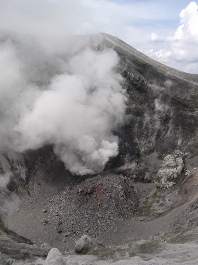 |
Figure 58. Photo of the new lava dome forming on 12 June 2013. Courtesy of RVO. |
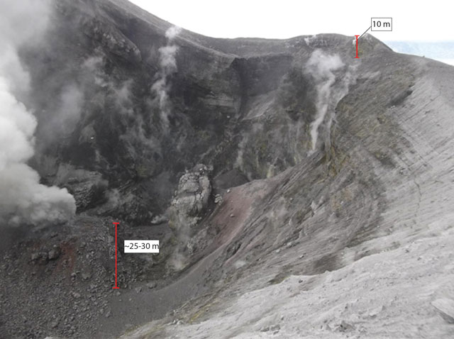 |
Figure 59. A new lava dome in Tavurvur, taken on 12 June 2013 with estimated scale bars. Courtesy of the RVO. |
On 26 June, incandescence was observed at a vent on the dome and was associated with strong venting of steam and ash, which continued to 14 July.
A few discrete explosions occurred on 10 July, producing moderate to dense gray ash clouds. This low level eruptive activity persisted until 9 September, with energetic explosions producing mostly light-to-pale-gray ash clouds that drifted NW and affected areas downwind. The eruptions occurred at a varying range of intervals from ten's of seconds to hours.
From 14 April to 14 July, several small low-frequency earthquakes occurred. The majority of these were too small to be located, but time series data suggest that they originated near Tavurvur. In early July, a recently restored seismic station near Tavurvur confirmed that earthquakes were occurring beneath Tavurvur volcano. The station also detected smaller earthquakes that other seismic stations had not recorded. On 15 July, the level of seismicity increased, with events concurrent with ash emissions. On 1 August, seismicity increased and remained elevated until 9 September; seismic events continued to be associated with ash emissions.
Ground deformation during this entire period remained relatively stable, reflecting the long-term trend of uplift. On 11 May, the base station antenna broke, resulting in a loss of GPS data. Ground measurements using water tube tilt meters showed a slight inflation recorded at Matupit Island (see figure 57). Throughout the entire month of August, ground measurements showed slight deflation, but the long term inflation trend resumed beginning on 1 September.
During 1-5 September, RVO stated that "people in Rabaul town reported an odor reflective of chlorine. The substance that caused the odor is normal output of volcanic processes but an uncommon one. Its presence does not represent anything unusual or increase in volcanic activity."
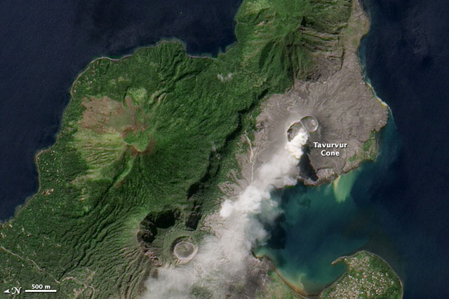 |
Figure 60. This natural color image of Tavurvur Cone emitting an ash plume on 6 August 2013 was acquired by the Advanced Land Imager (ALI) on the Earth Observing-1 (EO-1) satellite, and posted on the NASA Earth Observatory website. Note scale and N arrow at far left. Courtesy of Jesse Allen and Robert Simmon (Nasa Earth Observatory). |
September to November 2013. The Darwin VAAC observed one ash plume on 27 September 2013. The plume rose to an altitude of 2,400 m and drifted 110 km NE and NW. No other activity was recorded until mid- November.
On 13 November 2013, a moderate explosion at Tavurvur produced a dense, gray billowing plume of ash which rose 1000 m and blew NW. More explosions followed at irregular intervals, and continued until 18 November. Ash plumes from those explosions were blown E, SE, and NW at lower altitudes and rose to a maximum height of 1000 m. Between explosions, wisps of white vapor rose from the volcano. Large explosions occurred at 0738, 0851, 1308, and 1903 on 13 November, and the next day at 2044. RVO reported minor inflation at the center of the caldera. There was some roaring and rumbling, but seismicity was low with small low-frequency earthquakes occurring with explosions.
During 19-30 November, Tavurvur produced fewer explosions, accompanied by white to light gray emissions, and small traces of diffuse to dense white vapors were occasionally observed. Those plumes drifted E, SE, and NW at a maximum height of 1,000 m above the crater summit. Two small, high-frequency volcano-tectonic earthquakes were detected during 23-27 November and located NE of Tavurvur.
December 2013. Little activity occurred at Rabaul during December. Minor emissions of mainly diffuse, though occasionally dense, white vapor occurred. A blue tint to the emissions was reported on some days during the reporting periodThere were no audible noises except for two two moderate explosions at 1850 on 15 December and 0732 on 22 December. Neither explosion was ash rich. RVO noted a weak fluctuating glow visible at night on 31 December.
Geological Summary. The low-lying Rabaul caldera on the tip of the Gazelle Peninsula at the NE end of New Britain forms a broad sheltered harbor utilized by what was the island's largest city prior to a major eruption in 1994. The outer flanks of the asymmetrical shield volcano are formed by thick pyroclastic-flow deposits. The 8 x 14 km caldera is widely breached on the east, where its floor is flooded by Blanche Bay and was formed about 1,400 years ago. An earlier caldera-forming eruption about 7,100 years ago is thought to have originated from Tavui caldera, offshore to the north. Three small stratovolcanoes lie outside the N and NE caldera rims. Post-caldera eruptions built basaltic-to-dacitic pyroclastic cones on the caldera floor near the NE and W caldera walls. Several of these, including Vulcan cone, which was formed during a large eruption in 1878, have produced major explosive activity during historical time. A powerful explosive eruption in 1994 occurred simultaneously from Vulcan and Tavurvur volcanoes and forced the temporary abandonment of Rabaul city.
Information Contacts: Rabaul Volcano Observatory, Department of Mineral Policy and Geohazards Management, Volcanological Observatory Geohazards Management Division, P.O. Box 386, Kokopo, East New Britain Province, Papua New Guinea; and Darwin Volcanic Ash Advisory Centre (VAAC) (URL: http://www.bom.gov.au/info/vaac/); Nasa Earth Observatory (URL: http://earthobservatory.nasa.gov); and ABC Australia Network News (URL: http://www.abc.net.au/news-01-31/an-png-airport-reopens-after-volcano-forces-closure/4492838).