Report on Apoyeque (Nicaragua) — October 2013
Bulletin of the Global Volcanism Network, vol. 38, no. 10 (October 2013)
Managing Editor: Richard Wunderman.
Edited by Julie A. Herrick.
Apoyeque (Nicaragua) Seismic swarms in 2009 and 2012
Please cite this report as:
Global Volcanism Program, 2013. Report on Apoyeque (Nicaragua) (Herrick, J.A., and Wunderman, R., eds.). Bulletin of the Global Volcanism Network, 38:10. Smithsonian Institution. https://doi.org/10.5479/si.GVP.BGVN201310-344091
Apoyeque
Nicaragua
12.242°N, 86.342°W; summit elev. 518 m
All times are local (unless otherwise noted)
Within the last five years, Instituto Nicaragüense de Estudios Territoriales (INETER) reported at least two seismic swarms at Apoyeque, and between the Chiltepe Peninsula and the city of Managua (~15 km SE) (figure 1). Our last report also highlighted swarms which lasted several hours and days in 2001 and 2007 (BGVN 34:04). Intermittent seismicity was reported within the region during 2009-2012, but events were rarely larger than M 2.5.
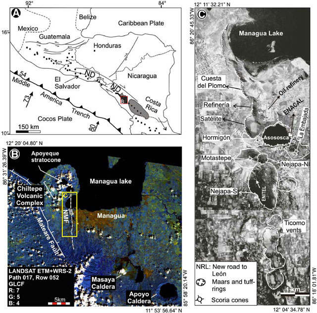 |
Figure 1. Regional maps showing Apoyeque and the tectonic setting. (A) Sketch map highlighting volcanic centers in Central America relative to the active subduction of Cocos Plate beneath the Caribbean Plate. In Nicaragua active volcanism is concentrated inside the Nicaragua Depression (ND). The red box labeled "B" refers to the 50 x 50 km area that includes Apoyeque on the Chiltepe Peninsula. (B) This Landsat 7 image corresponds to the extent of the red box labeled "B" in the sketch map "A"; the Nejapa-Miraflores fault (NMF) marks an offset in the main arc and frequently generates seismicity. (C) Along the NMF, mainly monogenetic volcanoes have formed W of Managua city. Modified from Pardo and others, 2009. |
2009 swarm. INETER reported a seismic swarm on 29 September 2009. It began at 1800 local time in an area W of Apoyeque volcano. The main event occurred at 1817 local time, with a ML 3.1 event at a depth of 5 km. The earthquake was felt by the population in Sandino City, ~5 km W of the earthquakes. The seismic swarm lasted until 2 October 2009; the total number of detected earthquakes was not disclosed.
2012 swarm. INETER reported a swarm that began at 1727 local time on 6 September 2012. The National Seismic Network detected and located the series of earthquakes between Apoyeque and the Nejapa-Miraflores fault (figure 1).
More than 20 earthquakes were detected and the two largest had magnitudes of 2.3 and 3.8, with depths of 2.8 and 6 km respectively; the largest event occurred at 1937 (figure 2). None of these earthquakes were reportedly felt by local populations and the event was assigned an Intensity II. The swarm lasted ~2 hours.
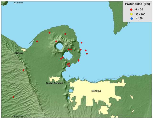 |
Figure 2. Epicenters of the largest earthquakes from the Apoyeque swarm are plotted. INETER detected ~20 earthquakes on 6 September 2012 all within 30 km depth. Courtesy of INETER. |
Avellán and others (2012) described the polygenetic Apoyeque volcano as belonging to the Nejapa volcanic field (figure 1), which is bound by the Nejapa fault system. There were 23 eruptions from the field within the last ~30 ka; 13 of these events were explosive (VEI 2). The most recent eruption was dated between 2,130 ± 40 and 1,245 ± 120 years BP. With respect to hazards implications, clear vent migration patterns were seemingly absent for this volcanic field. The authors concluded that there is a high probability of future, similar eruptions, particularly phreatomagmatic ones, within this area of Nicaragua.
References: Avellán, D.R., Macías, J.L., Pardo, N., Scolamacchia, T., and Rodriguez, D., 2012, Stratigraphy, geomorphology, geochemistry and hazard implications of the Nejapa Volcanic Field, western Managua, Nicaragua, Journal of Volcanology and Geothermal Research, 213-214: 51-71.
Pardo, N., Macías, J.L., Giordano, G., Cianfarra, P., Avellán, D.R., and Bellatreccia, F., 2009, The ~1245 yr BP Asososca maar eruption: The youngest event along the Nejapa-Miraflores volcanic fault, Western Managua, Nicaragua, Journal of Volcanology and Geothermal Research, 184: 292-312.
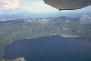
Geological Summary. The Apoyeque volcanic complex occupies the broad Chiltepe Peninsula, which extends into south-central Lake Managua. The peninsula is part of the Chiltepe pyroclastic shield volcano, one of three large ignimbrite shields on the Nicaraguan volcanic front. A 2.8-km wide, 400-m-deep, lake-filled caldera whose floor lies near sea level truncates the low Apoyeque edifice, which rises only about 500 m above the lake shore. The caldera was the source of a thick deposit of dacitic pumice that covers the surrounding area. The 2.5 x 3 km lake-filled Xiloá (Jiloá) maar is located immediately SE of Apoyeque. The Talpetatl lava dome was constructed between Laguna Xiloá and Lake Managua. Pumiceous pyroclastic flows from Laguna Xiloá were erupted about 6,100 years ago and overlie deposits of comparable age from the Masaya Plinian eruption.
Information Contacts: Instituto Nicaragüense de Estudios Territoriales (INETER), Apartado Postal 2110, Managua, Nicaragua (URL: http://www.ineter.gob.ni/).