INETER reported that a seismic swarm near Apoyeque started at 1627 on 6 September in an area between the volcano and Managua (less than 10 km SW). At the time of the report, almost four hours after the start of the event, 17 earthquakes had been detected; three events were M 2.3-3.7, at depths ranging from 2.8 to 6 km. No earthquakes were recorded on 9 September.
Source: Instituto Nicaragüense de Estudios Territoriales (INETER)
Seismic swarms in 2009 and 2012
Within the last five years, Instituto Nicaragüense de Estudios Territoriales (INETER) reported at least two seismic swarms at Apoyeque, and between the Chiltepe Peninsula and the city of Managua (~15 km SE) (figure 1). Our last report also highlighted swarms which lasted several hours and days in 2001 and 2007 (BGVN 34:04). Intermittent seismicity was reported within the region during 2009-2012, but events were rarely larger than M 2.5.
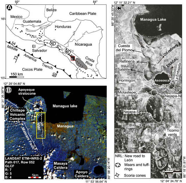 |
Figure 1. Regional maps showing Apoyeque and the tectonic setting. (A) Sketch map highlighting volcanic centers in Central America relative to the active subduction of Cocos Plate beneath the Caribbean Plate. In Nicaragua active volcanism is concentrated inside the Nicaragua Depression (ND). The red box labeled "B" refers to the 50 x 50 km area that includes Apoyeque on the Chiltepe Peninsula. (B) This Landsat 7 image corresponds to the extent of the red box labeled "B" in the sketch map "A"; the Nejapa-Miraflores fault (NMF) marks an offset in the main arc and frequently generates seismicity. (C) Along the NMF, mainly monogenetic volcanoes have formed W of Managua city. Modified from Pardo and others, 2009. |
2009 swarm. INETER reported a seismic swarm on 29 September 2009. It began at 1800 local time in an area W of Apoyeque volcano. The main event occurred at 1817 local time, with a ML 3.1 event at a depth of 5 km. The earthquake was felt by the population in Sandino City, ~5 km W of the earthquakes. The seismic swarm lasted until 2 October 2009; the total number of detected earthquakes was not disclosed.
2012 swarm. INETER reported a swarm that began at 1727 local time on 6 September 2012. The National Seismic Network detected and located the series of earthquakes between Apoyeque and the Nejapa-Miraflores fault (figure 1).
More than 20 earthquakes were detected and the two largest had magnitudes of 2.3 and 3.8, with depths of 2.8 and 6 km respectively; the largest event occurred at 1937 (figure 2). None of these earthquakes were reportedly felt by local populations and the event was assigned an Intensity II. The swarm lasted ~2 hours.
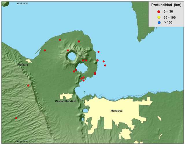 |
Figure 2. Epicenters of the largest earthquakes from the Apoyeque swarm are plotted. INETER detected ~20 earthquakes on 6 September 2012 all within 30 km depth. Courtesy of INETER. |
Avellán and others (2012) described the polygenetic Apoyeque volcano as belonging to the Nejapa volcanic field (figure 1), which is bound by the Nejapa fault system. There were 23 eruptions from the field within the last ~30 ka; 13 of these events were explosive (VEI 2). The most recent eruption was dated between 2,130 ± 40 and 1,245 ± 120 years BP. With respect to hazards implications, clear vent migration patterns were seemingly absent for this volcanic field. The authors concluded that there is a high probability of future, similar eruptions, particularly phreatomagmatic ones, within this area of Nicaragua.
References: Avellán, D.R., Macías, J.L., Pardo, N., Scolamacchia, T., and Rodriguez, D., 2012, Stratigraphy, geomorphology, geochemistry and hazard implications of the Nejapa Volcanic Field, western Managua, Nicaragua, Journal of Volcanology and Geothermal Research, 213-214: 51-71.
Pardo, N., Macías, J.L., Giordano, G., Cianfarra, P., Avellán, D.R., and Bellatreccia, F., 2009, The ~1245 yr BP Asososca maar eruption: The youngest event along the Nejapa-Miraflores volcanic fault, Western Managua, Nicaragua, Journal of Volcanology and Geothermal Research, 184: 292-312.
Information Contacts: Instituto Nicaragüense de Estudios Territoriales (INETER), Apartado Postal 2110, Managua, Nicaragua (URL: http://www.ineter.gob.ni/).
2012: September
INETER reported that a seismic swarm near Apoyeque started at 1627 on 6 September in an area between the volcano and Managua (less than 10 km SW). At the time of the report, almost four hours after the start of the event, 17 earthquakes had been detected; three events were M 2.3-3.7, at depths ranging from 2.8 to 6 km. No earthquakes were recorded on 9 September.
Source: Instituto Nicaragüense de Estudios Territoriales (INETER)
Reports are organized chronologically and indexed below by Month/Year (Publication Volume:Number), and include a one-line summary. Click on the index link or scroll down to read the reports.
Sulfur smell from active fumaroles
The surface temperature of the crater lake was 28.1-28.8°C on 16 January at 0900. A slight smell of sulfur was evident at the N caldera rim, probably originating from fumaroles 100-200 m below. Fumaroles also remained active in Laguna Jiloa.
Information Contacts: B. van Wyk de Vries, H. Rymer, and G. Brown, Open Univ; P. Hradecky and H. Taleno, INETER.
Lake temperature measured
Surface temperature of the lake (measured with an 8-14 micrometer bandpass radiometer) varied between 28 and 30°C during fieldwork 8 April. A water temperature measured near the N shore was 25.5°C.
Information Contacts: C. Oppenheimer, Open Univ.
Repose continues, punctuated by occasional seismic swarms in 2001 and 2007
Seismic swarms took place during 2001 and 2007. The last overview of Apoyeque (BGVN14:04) reported slight variations of the crater lake's surface temperature of between 25 and 30°C (which began to rise in 1988). Faint sulfurous odors were noted as well as some active fumaroles.
Swarms were reported by INETER (Instituto Nicarag?ense de Estudios Territoriales) in a 23 September 2007 report. The first swarm, during January 2001, included earthquakes up to MR 5.2. This swarm was felt strongly in the cities of Managua (~ 8 km away) and in Ciudad Sandino. No damage was reported. The second swarm began on 21 September 2007, becoming more intense on 23 September, by which time there had been 10 earthquakes up to MR 2.8. Scores of smaller earthquakes were also detected at a seismometer in Apoyeque's crater.
INETER stated that, based on past cases at this volcano, such swarms can continue for days and might reach M 4-M 5 (as they had in January 2001). The typical pattern is for a series of smaller volcanic earthquakes to precede one or more larger ones. This is in contrast to earthquakes associated with the subduction of the Cocos plate, where larger earthquakes often precede substantially smaller ones.
Apoyeque remains in repose without documented historical eruptions. Tephrochronology (the study of ash layers, in this case including radiometric dating) indicates the most recent eruption here was large and took place about 50 BC (? 100 years) depositing the Chiltepe tephra. That tephra deposit has an estimated 4 km3 on-land volume and a total volume (including the offshore component) of about 18 km3(Kutterolf and others, 2008).
Reference. Kutterolf, S., Freundt, A., and Perez, W., 2008, Pacific offshore record of Plinian arc volcanism in Central America: 2. Tephra Volumes and erupted masses: Geochemistry, Geophysics, Geosystems (G3), v. 8, Q02S02, doi: 10.1029/2007GC001791.
Information Contacts: Instituto Nicaraguense de Estudios Territoriales (INETER), Apartado Postal 2110, Managua, Nicaragua.
Seismic swarms in 2009 and 2012
Within the last five years, Instituto Nicaragüense de Estudios Territoriales (INETER) reported at least two seismic swarms at Apoyeque, and between the Chiltepe Peninsula and the city of Managua (~15 km SE) (figure 1). Our last report also highlighted swarms which lasted several hours and days in 2001 and 2007 (BGVN 34:04). Intermittent seismicity was reported within the region during 2009-2012, but events were rarely larger than M 2.5.
|
Figure 1. Regional maps showing Apoyeque and the tectonic setting. (A) Sketch map highlighting volcanic centers in Central America relative to the active subduction of Cocos Plate beneath the Caribbean Plate. In Nicaragua active volcanism is concentrated inside the Nicaragua Depression (ND). The red box labeled "B" refers to the 50 x 50 km area that includes Apoyeque on the Chiltepe Peninsula. (B) This Landsat 7 image corresponds to the extent of the red box labeled "B" in the sketch map "A"; the Nejapa-Miraflores fault (NMF) marks an offset in the main arc and frequently generates seismicity. (C) Along the NMF, mainly monogenetic volcanoes have formed W of Managua city. Modified from Pardo and others, 2009. |
2009 swarm. INETER reported a seismic swarm on 29 September 2009. It began at 1800 local time in an area W of Apoyeque volcano. The main event occurred at 1817 local time, with a ML 3.1 event at a depth of 5 km. The earthquake was felt by the population in Sandino City, ~5 km W of the earthquakes. The seismic swarm lasted until 2 October 2009; the total number of detected earthquakes was not disclosed.
2012 swarm. INETER reported a swarm that began at 1727 local time on 6 September 2012. The National Seismic Network detected and located the series of earthquakes between Apoyeque and the Nejapa-Miraflores fault (figure 1).
More than 20 earthquakes were detected and the two largest had magnitudes of 2.3 and 3.8, with depths of 2.8 and 6 km respectively; the largest event occurred at 1937 (figure 2). None of these earthquakes were reportedly felt by local populations and the event was assigned an Intensity II. The swarm lasted ~2 hours.
|
Figure 2. Epicenters of the largest earthquakes from the Apoyeque swarm are plotted. INETER detected ~20 earthquakes on 6 September 2012 all within 30 km depth. Courtesy of INETER. |
Avellán and others (2012) described the polygenetic Apoyeque volcano as belonging to the Nejapa volcanic field (figure 1), which is bound by the Nejapa fault system. There were 23 eruptions from the field within the last ~30 ka; 13 of these events were explosive (VEI 2). The most recent eruption was dated between 2,130 ± 40 and 1,245 ± 120 years BP. With respect to hazards implications, clear vent migration patterns were seemingly absent for this volcanic field. The authors concluded that there is a high probability of future, similar eruptions, particularly phreatomagmatic ones, within this area of Nicaragua.
References: Avellán, D.R., Macías, J.L., Pardo, N., Scolamacchia, T., and Rodriguez, D., 2012, Stratigraphy, geomorphology, geochemistry and hazard implications of the Nejapa Volcanic Field, western Managua, Nicaragua, Journal of Volcanology and Geothermal Research, 213-214: 51-71.
Pardo, N., Macías, J.L., Giordano, G., Cianfarra, P., Avellán, D.R., and Bellatreccia, F., 2009, The ~1245 yr BP Asososca maar eruption: The youngest event along the Nejapa-Miraflores volcanic fault, Western Managua, Nicaragua, Journal of Volcanology and Geothermal Research, 184: 292-312.
Information Contacts: Instituto Nicaragüense de Estudios Territoriales (INETER), Apartado Postal 2110, Managua, Nicaragua (URL: http://www.ineter.gob.ni/).
|
|
||||||||||||||||||||||||||
There is data available for 4 confirmed Holocene eruptive periods.
0050 BCE ± 100 years Confirmed Eruption (Explosive / Effusive) VEI: 6
| Episode 1 | Eruption (Explosive / Effusive) | Apoyeque, Chiltepe Tephra | |||||||||||||||||||||||||||||||||||||||||||||||||
|---|---|---|---|---|---|---|---|---|---|---|---|---|---|---|---|---|---|---|---|---|---|---|---|---|---|---|---|---|---|---|---|---|---|---|---|---|---|---|---|---|---|---|---|---|---|---|---|---|---|---|
| 0050 BCE ± 100 years - Unknown | Evidence from Correlation: Tephrochronology | |||||||||||||||||||||||||||||||||||||||||||||||||
|
List of 8 Events for Episode 1 at Apoyeque, Chiltepe Tephra
|
||||||||||||||||||||||||||||||||||||||||||||||||||
1050 BCE ± 1000 years Confirmed Eruption (Explosive / Effusive) VEI: 4
| Episode 1 | Eruption (Explosive / Effusive) | Los Cedros Tephra | |||||||||||||||||||||||||||||
|---|---|---|---|---|---|---|---|---|---|---|---|---|---|---|---|---|---|---|---|---|---|---|---|---|---|---|---|---|---|---|
| 1050 BCE ± 1000 years - Unknown | Evidence from Correlation: Tephrochronology | |||||||||||||||||||||||||||||
|
List of 4 Events for Episode 1 at Los Cedros Tephra
|
||||||||||||||||||||||||||||||
2550 BCE ± 1500 years Confirmed Eruption (Explosive / Effusive) VEI: 5
| Episode 1 | Eruption (Explosive / Effusive) | W Chiltepe Peninsula, Mateare Tephra | |||||||||||||||||||||||||||||||||||||||||||||||||
|---|---|---|---|---|---|---|---|---|---|---|---|---|---|---|---|---|---|---|---|---|---|---|---|---|---|---|---|---|---|---|---|---|---|---|---|---|---|---|---|---|---|---|---|---|---|---|---|---|---|---|
| 2550 BCE ± 1500 years - Unknown | Evidence from Correlation: Tephrochronology | |||||||||||||||||||||||||||||||||||||||||||||||||
|
List of 8 Events for Episode 1 at W Chiltepe Peninsula, Mateare Tephra
|
||||||||||||||||||||||||||||||||||||||||||||||||||
4160 BCE ± 30 years Confirmed Eruption (Explosive / Effusive) VEI: 5
| Episode 1 | Eruption (Explosive / Effusive) | Laguna Xiloá | |||||||||||||||||||||||||||||||||||||||
|---|---|---|---|---|---|---|---|---|---|---|---|---|---|---|---|---|---|---|---|---|---|---|---|---|---|---|---|---|---|---|---|---|---|---|---|---|---|---|---|---|
| 4160 BCE ± 30 years - Unknown | Evidence from Isotopic: 14C (uncalibrated) | |||||||||||||||||||||||||||||||||||||||
|
List of 6 Events for Episode 1 at Laguna Xiloá
|
||||||||||||||||||||||||||||||||||||||||
This compilation of synonyms and subsidiary features may not be comprehensive. Features are organized into four major categories: Cones, Craters, Domes, and Thermal Features. Synonyms of features appear indented below the primary name. In some cases additional feature type, elevation, or location details are provided.
Synonyms |
||||
| Chiltepe | ||||
Craters |
||||
| Feature Name | Feature Type | Elevation | Latitude | Longitude |
| Xiloá
Jiloá |
Caldera | 383 m | 12° 13' 0.00" N | 86° 19' 0.00" W |
Domes |
||||
| Feature Name | Feature Type | Elevation | Latitude | Longitude |
| Chiltepe, Volcán | Dome | 228 m | 12° 13' 59.00" N | 86° 17' 46.00" W |
| Miraflores | Dome | 12° 11' 2.00" N | 86° 19' 59.00" W | |
| Talpetate, Cerro | Dome | 144 m | 12° 12' 18.00" N | 86° 19' 37.00" W |
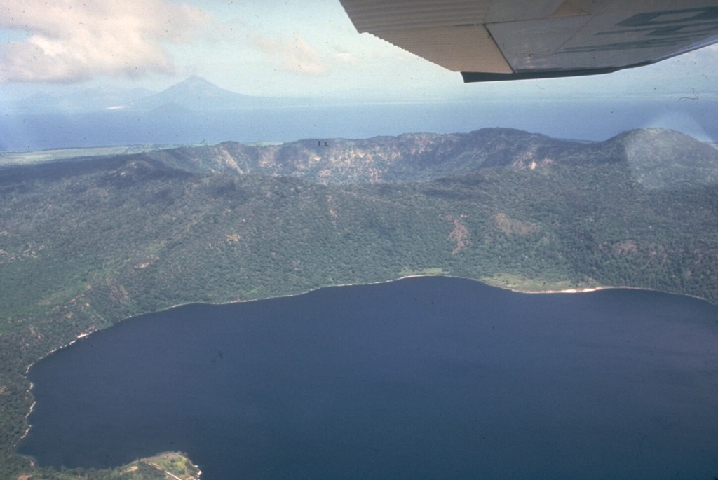
 Apoyeque stratovolcano forms the large Chiltepe Peninsula in central Lake Managua. A 2.8-km wide, 500-m-deep caldera truncates the volcano's summit, below and to the left of the airplane wing. Laguna de Jiloa, the large lake in the foreground, lies immediately SE of Apoyeque. The age of the latest eruption of Apoyeque is not known, but human footprints underlie pumice deposits thought to originate from Apoyeque volcano or a nearby vent beneath Lake Managua. Momotombo volcano is visible in the distance to the NW across Lake Managua.
 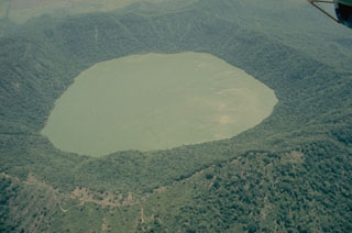 The forested Apoyeque stratovolcano is truncated by a 2.8-km-wide lake-filled caldera, seen here from the west. Another lake-filled caldera, Laguna de Jiloa, is located immediately to the SE.
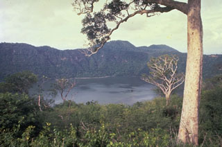 The summit caldera of Apoyeque volcano is filled by a scenic lake. The age of the latest eruption of Apoyeque is not known, but human footprints underlie pumice deposits thought to originate from Apoyeque volcano or a nearby vent beneath Lake Managua. This view is from the west caldera rim with the Chiltepe Hills in the background.
 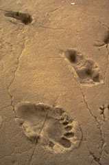 An archaeological site at Acahualinca near Managua exposes human footprints that were covered by voluminous pumice-fall deposits from Apoyeque volcano. The footprints are older than the overlying ca. 6500 yrs Before Present (BP) Jiloa Pumice and may occur within a ca. 7500 yrs BP mudflow deposit from Masaya volcano and thus range between about 6500 and 7500 yrs BP. These renowned footprints are the oldest indication of human habitation in the Managua area.
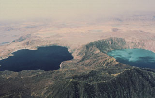 The deep blue Laguna de Jiloa (left) and the turquoise-colored Laguna Apoyeque dramatically fill two calderas on the Chiltepe Peninsula north of Managua. The 2.8-km-wide Apoyeque caldera, the source of the major Chiltepe Pumice about 2000 years ago, has a more circular outline than the scalloped 2.5 x 3 km wide Jiloa caldera, which was the site of a major explosive eruption about 6500 years ago.
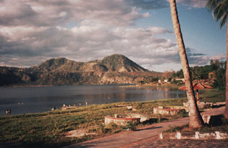 The SE shore of Laguna de Jiloa is the site of tourist resorts that are popular destinations from the nearby capital city of Managua. The Chiltepe Hills on the horizon beyond the caldera rim to the north are the high points of the Chiltepe Peninsula.
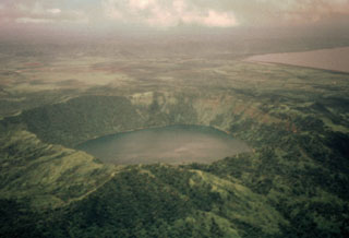 Laguna de Apoyeque fills a 2.8-km-wide caldera constructed at the center of the Chiltepe Peninsula. The caldera rim rises about 400 m above the lake, whose surface lies only about 40 m above sea level. Two major pumice deposits erupted about 18,000-25,000 years ago originated from Apoyeque caldera. The Lower Apoyeque pumice was erupted about 22,000-25,000 years ago, while the Upper Apoyeque pumice, which forms a distinctive layer in the Managua area, was erupted a few thousand years later. Lake Managua lies at the upper right.
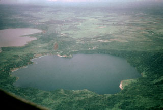 Laguna de Jiloa was the source of a major explosive eruption about 6500 years ago that deposited the widespread Jiloa Pumice, which blankets the Managua area. Laguna de Jiloa (also spelled Xiloa) is seen here in an aerial view from the north with Lake Managua at the upper left. The rim of the 2.5-km-wide caldera is lowest on the SE (left) and rises to 220 m on the NW side. Cones of the Nejapa-Miraflores alignment can be seen extending to the south from the center of the far caldera rim.
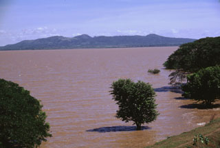 The broad Chiltepe Peninsula rises to the SE across the flood-stained waters of Lake Managua. Apoyeque caldera lies beyond its horizontal rim on the right-center horizon. The 11-km-wide peninsula extends into Lake Managua and marks the northern limit of a segment of the central Nicaraguan volcanic chain that is offset to the east.
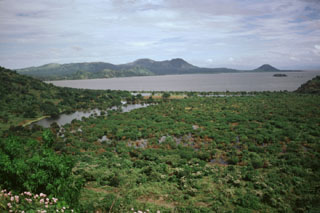 The Chiltepe Peninsula is seen across Lake Managua from the south on the outskirts of the city of Managua. The broad peninsula extends into the lake about 6 km north of the city and lies at the northern end of a chain of pyroclastic cones and craters that extends into the city. The small conical peak on the far right horizon is Volcán Chiltepe.
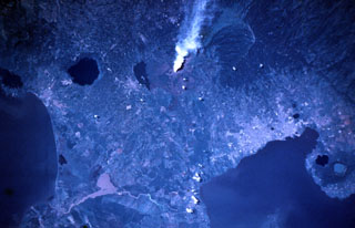 A vigorous steam plume pours from Masaya volcano in this November 9, 1984 Space Shuttle image taken near the end of a two-decade-long eruptive episode. North lies to the lower right, with Lake Nicaragua at the lower left and Lake Managua at the lower right. To the left of the plume from Santiago crater is Lake Masaya (ponded against the rim of Masaya caldera) and the circular lake-filled Apoyo caldera. The two caldera lakes at the lower right are Apoyeque (light blue) and Jiloa (dark-colored), across the bay from the city of Managua.
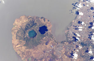 Two lake-filled calderas dominate the 11-km-wide Chiltepe Peninsula extending NE-ward into Lake Managua. Greenish Lake Apoyeque was the source of two major late-Pleistocene plinian pumice deposits, and dark-blue Lake Jiloa (Xiloa) produced the Jiloa Pumice about 6500 years ago. The two calderas cut the summit of the Chiltepe pyroclastic shield volcano. Nicaragua's capital city Managua, extending across much of the right side of the image, has been subjected to major tectonic earthquakes.
 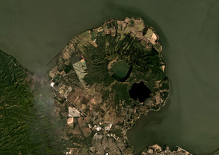 The Apoyeque caldera to the left and the Xiloá Maar to the right are part of the Apoyeque volcanic complex shown in this December 2019 Planet Labs satellite image monthly mosaic (N is at the top; this image is approximately 27 km across). Apoyeque is one of 11 features within the Chiltepe Volcanic Complex at the northern end of the Nejapa Volcanic Field. The ridge to the ENE of the caldera is composed of cones, domes, and lava flows, and Cerro Talpetate is south of the maar.
There are no samples for Apoyeque in the Smithsonian's NMNH Department of Mineral Sciences Rock and Ore collection.
| Copernicus Browser | The Copernicus Browser replaced the Sentinel Hub Playground browser in 2023, to provide access to Earth observation archives from the Copernicus Data Space Ecosystem, the main distribution platform for data from the EU Copernicus missions. |
| MIROVA | Middle InfraRed Observation of Volcanic Activity (MIROVA) is a near real time volcanic hot-spot detection system based on the analysis of MODIS (Moderate Resolution Imaging Spectroradiometer) data. In particular, MIROVA uses the Middle InfraRed Radiation (MIR), measured over target volcanoes, in order to detect, locate and measure the heat radiation sourced from volcanic activity. |
| MODVOLC Thermal Alerts | Using infrared satellite Moderate Resolution Imaging Spectroradiometer (MODIS) data, scientists at the Hawai'i Institute of Geophysics and Planetology, University of Hawai'i, developed an automated system called MODVOLC to map thermal hot-spots in near real time. For each MODIS image, the algorithm automatically scans each 1 km pixel within it to check for high-temperature hot-spots. When one is found the date, time, location, and intensity are recorded. MODIS looks at every square km of the Earth every 48 hours, once during the day and once during the night, and the presence of two MODIS sensors in space allows at least four hot-spot observations every two days. Each day updated global maps are compiled to display the locations of all hot spots detected in the previous 24 hours. There is a drop-down list with volcano names which allow users to 'zoom-in' and examine the distribution of hot-spots at a variety of spatial scales. |
|
WOVOdat
Single Volcano View Temporal Evolution of Unrest Side by Side Volcanoes |
WOVOdat is a database of volcanic unrest; instrumentally and visually recorded changes in seismicity, ground deformation, gas emission, and other parameters from their normal baselines. It is sponsored by the World Organization of Volcano Observatories (WOVO) and presently hosted at the Earth Observatory of Singapore.
GVMID Data on Volcano Monitoring Infrastructure The Global Volcano Monitoring Infrastructure Database GVMID, is aimed at documenting and improving capabilities of volcano monitoring from the ground and space. GVMID should provide a snapshot and baseline view of the techniques and instrumentation that are in place at various volcanoes, which can be use by volcano observatories as reference to setup new monitoring system or improving networks at a specific volcano. These data will allow identification of what monitoring gaps exist, which can be then targeted by remote sensing infrastructure and future instrument deployments. |
| Volcanic Hazard Maps | The IAVCEI Commission on Volcanic Hazards and Risk has a Volcanic Hazard Maps database designed to serve as a resource for hazard mappers (or other interested parties) to explore how common issues in hazard map development have been addressed at different volcanoes, in different countries, for different hazards, and for different intended audiences. In addition to the comprehensive, searchable Volcanic Hazard Maps Database, this website contains information about diversity of volcanic hazard maps, illustrated using examples from the database. This site is for educational purposes related to volcanic hazard maps. Hazard maps found on this website should not be used for emergency purposes. For the most recent, official hazard map for a particular volcano, please seek out the proper institutional authorities on the matter. |
| IRIS seismic stations/networks | Incorporated Research Institutions for Seismology (IRIS) Data Services map showing the location of seismic stations from all available networks (permanent or temporary) within a radius of 0.18° (about 20 km at mid-latitudes) from the given location of Apoyeque. Users can customize a variety of filters and options in the left panel. Note that if there are no stations are known the map will default to show the entire world with a "No data matched request" error notice. |
| UNAVCO GPS/GNSS stations | Geodetic Data Services map from UNAVCO showing the location of GPS/GNSS stations from all available networks (permanent or temporary) within a radius of 20 km from the given location of Apoyeque. Users can customize the data search based on station or network names, location, and time window. Requires Adobe Flash Player. |
| DECADE Data | The DECADE portal, still in the developmental stage, serves as an example of the proposed interoperability between The Smithsonian Institution's Global Volcanism Program, the Mapping Gas Emissions (MaGa) Database, and the EarthChem Geochemical Portal. The Deep Earth Carbon Degassing (DECADE) initiative seeks to use new and established technologies to determine accurate global fluxes of volcanic CO2 to the atmosphere, but installing CO2 monitoring networks on 20 of the world's 150 most actively degassing volcanoes. The group uses related laboratory-based studies (direct gas sampling and analysis, melt inclusions) to provide new data for direct degassing of deep earth carbon to the atmosphere. |
| Large Eruptions of Apoyeque | Information about large Quaternary eruptions (VEI >= 4) is cataloged in the Large Magnitude Explosive Volcanic Eruptions (LaMEVE) database of the Volcano Global Risk Identification and Analysis Project (VOGRIPA). |
| EarthChem | EarthChem develops and maintains databases, software, and services that support the preservation, discovery, access and analysis of geochemical data, and facilitate their integration with the broad array of other available earth science parameters. EarthChem is operated by a joint team of disciplinary scientists, data scientists, data managers and information technology developers who are part of the NSF-funded data facility Integrated Earth Data Applications (IEDA). IEDA is a collaborative effort of EarthChem and the Marine Geoscience Data System (MGDS). |

