Report on Colima (Mexico) — December 2013

Bulletin of the Global Volcanism Network, vol. 38, no. 12 (December 2013)
Managing Editor: Richard Wunderman.
Colima (Mexico) Episode of lava effusion following the January 2013 sequence of explosions
Please cite this report as:
Global Volcanism Program, 2013. Report on Colima (Mexico) (Wunderman, R., ed.). Bulletin of the Global Volcanism Network, 38:12. Smithsonian Institution. https://doi.org/10.5479/si.GVP.BGVN201312-341040
Colima
Mexico
19.514°N, 103.62°W; summit elev. 3850 m
All times are local (unless otherwise noted)
[Following 18-months of calm at Volcán de Colima (BGVN 38:04), a sequence of intermediate-to-small size Vulcanian explosions began in January 2013.] This sequence of explosions excavated a 250,000 m3 crater in the 2007-2011 lava dome (figure 105). Episodes of effusive activity within the new crater were recorded between the explosive events. An infrared image shows fresh magma at the crater base (figure 106).
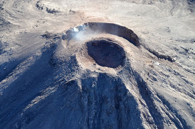 |
Figure 105. The new crater at Colima that was formed during the January 2013 explosive sequence. Photo was taken on 31 January 2013 during a flight of Civil Protection of Jalisco State. Courtesy of Colima Volcano Observatory. |
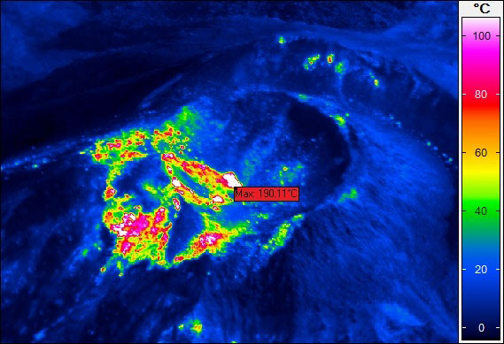 |
Figure 106. Thermal image taken during a flight over Colima on 11 January showing the emergence of fresh high temperature lava. Courtesy of Facultad de Ciencias, University of Colima. |
Activity during 2013. [There were three stages of activity at Colima during 2013, defined based on data from seismic and video monitoring (figure 107).] The first stage (St. 1) refers to the sequence of explosions described in (BGVN 38:04). On 15 February and the end of March (St. 2), video observations indicated continued gradual lava dome growth in the new crater. The dome increased in height at the rate of ~1 m/day. As a result, during this interval the [summit elevation] increased from 3,843 to 3,874 m. The dome continued to fill the crater through the end of March (figure 108). During April-November 2013 the third stage (St. 3) of significant dome growth stopped. The February-March lava dome growth was accompanied by an increase in the frequency and energy of the small explosions. Once the dome filled the crater a small lava flow traveled toward the W. Due to the steepness of this flank, much of the fresh material descended as rockfalls, whose frequency increased from April.
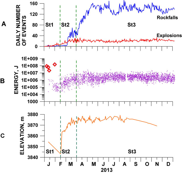 |
Figure 107. Plots A-C describe the development of the 2013 eruption at VolcÁn de Colima., showing three stages of development: Stage One (St. 1), involving explosions; Stage Two (St. 2), involving dome growth and extra-crater lava flow; and Stage Three (St. 3), involving lack of measurable dome growth but with ongoing explosions. (A) Daily variations in the number of small explosions and rockfalls identified from a seismometer 4 km from the crater. (B) Variations in the radiated seismic energy of explosive events recorded at a distance of 4 km. The four largest explosions of the St.1 are shown with diamonds. (C) Variations in the maximum elevation of the growing lava dome based on continuous video monitoring. Courtesy of Colima Volcano Observatory. |
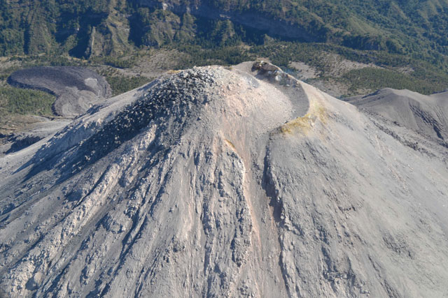 |
Figure 108. The filled crater and the lava flow that was formed during the second stage of activity on Colima's western slope. Photo was taken on 19 [March] 2013 during a flight of Civil Protection of Jalisco State. Courtesy of Colima Volcano Observatory. |
During the third stage, the daily number of small explosions and rockfalls was quite stable. This stage was associated with the occurrence of 14 lahars that began with the rainy season being registered between 11 June and 8 October 2013 descending the flanks of the volcano (figure 109). The largest, lasting around 6 hours, occurred on 16 September 2013, when the Pacific coast was affected by tropical cyclone Manuel.
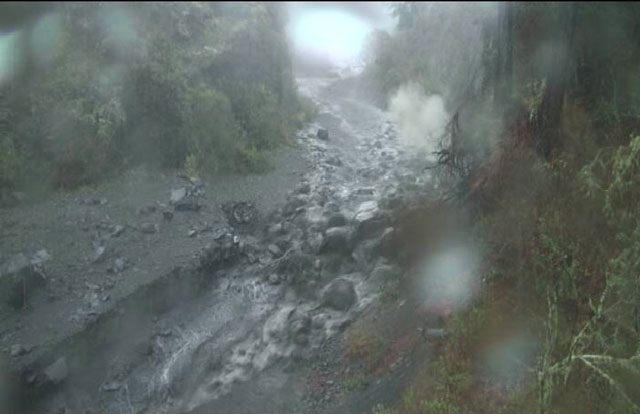 |
Figure 109. Block-rich front of the 11 June 2013 lahar recorded along the Montegrande ravine by the lahar monitoring station located 5.8 km S of the crater. Courtesy of Centro de Geociencias, UNAM. |
Activity during 2014. On 21 January 2014 the Washington VAAC first reported scattered ash emissions drifting S at 4.9 km altitude followed by a second and third emission that drifted SSW and S, respectively. Smaller ash emissions were noted throughout the following weeks. For example, Washington VAAC reported that on 7 February a small emission rose and drifted E then SE, followed by a later one the same day that drifted SE. From data provided by the Mexico Meteorological Watch Office, on 28 February an ash emission drifted 15 km SE at altitudes up to 4.6 km, and the following day, on 1 March, two emissions were reported drifting NNW, followed by three other plumes later the same day. The Washington VACC continued to report on activity as seen from satellite imaging, noting another emission on 6 March that drifted NE before dissipating and ; an emission on 12 March that drifted 25 km NNE before similarly dissipating; and a 19 March emission, which rose to 4.6 km and drifted E before dissipating 30 km from the source. A separate later plume followed on 22 March and drifted N.
Geological Summary. The Colima complex is the most prominent volcanic center of the western Mexican Volcanic Belt. It consists of two southward-younging volcanoes, Nevado de Colima (the high point of the complex) on the north and the historically active Volcán de Colima at the south. A group of late-Pleistocene cinder cones is located on the floor of the Colima graben west and east of the complex. Volcán de Colima (also known as Volcán Fuego) is a youthful stratovolcano constructed within a 5-km-wide scarp, breached to the south, that has been the source of large debris avalanches. Major slope failures have occurred repeatedly from both the Nevado and Colima cones, producing thick debris-avalanche deposits on three sides of the complex. Frequent recorded eruptions date back to the 16th century. Occasional major explosive eruptions have destroyed the summit (most recently in 1913) and left a deep, steep-sided crater that was slowly refilled and then overtopped by lava dome growth.
Information Contacts: Observatorio Vulcanologico de la Universidad de Colima (Colima Volcanological Observatory), Calle Manuel Payno, 209 Colima, Col., 28045 Mexico (URL: http://www.ucol.mex/volc/); Facultad de Ciencias, Universidad de Colima; and Washington Volcanic Ash Advisory Center (VAAC), NOAA Science Center Room 401, 5200 Auth road, Camp Springs, MD 20746, USA (URL: http://www.ospo.noaa.gov/Products/atmosphere/vaac/).