Report on Batu Tara (Indonesia) — January 2014
Bulletin of the Global Volcanism Network, vol. 39, no. 1 (January 2014)
Managing Editor: Richard Wunderman.
Batu Tara (Indonesia) Strombolian and vulcanian eruptions frequent during 2011-May 2014
Please cite this report as:
Global Volcanism Program, 2014. Report on Batu Tara (Indonesia) (Wunderman, R., ed.). Bulletin of the Global Volcanism Network, 39:1. Smithsonian Institution. https://doi.org/10.5479/si.GVP.BGVN201401-264260
Batu Tara
Indonesia
7.791°S, 123.585°E; summit elev. 633 m
All times are local (unless otherwise noted)
We previously reported Batu Tara activity through October 2011 (BGVN 36:10). This report describes events from November 2011 to May 2014. If not specifically referenced, the material here was compiled from events reported by the Darwin Volcano Air Advisory Center (VAAC). The Darwin VAAC compiled satellite information, ground reports from volcanological agencies, pilot reports, meteorological data and numerical models to track and forecast ash movements. Their product is called a Volcanic Ash Advisory (VAA). Batu Tara lies along the flight path between Jakarta, Indonesia and Sydney, Australia (Sonnabend, 2007). The other reference, Volcano Discovery, provided informative narratives and photos.
October 2011-December 2013 eruptions. There were ~90 ashfall VAA's reported by Darwin VAAC during the October 2011-December 2013 period. The 2011-2013 monthly ash fall summaries are listed in table 6.
Gaps in the Darwin VAAC Batu Tara archive existed, most notable for the month of December 2013, a month without archived VAA's. Volcano Discovery, however, compiled several comments on ash falls during the reporting interval, augmenting available information with in situ observations. Ash plumes were detected frequently during 2012 and 2013 (table 6). Plume altitudes during 2011-2013 were typically to ~2 km and occasionally to ~3 km.
Table 6. Batu Tara ash fall monthly summaries for October 2011-December 2013. Courtesy of the Darwin VAAC.
| Month | 2011 Eruptions | 2012 Eruptions | 2013 Eruptions |
| Jan | -- | -- | Stronger than normal eruption |
| Feb | -- | Ash plume eruption | Becoming more active |
| Mar | -- | Stronger than normal eruption | Elevated near-continuous strombolian explosions |
| Apr | -- | Occasional ash eruptions | Continuing, often strong strombolian activity |
| May | -- | Occasional ash eruptions | Ash plumes |
| Jun | -- | Occasional ash eruptions | Continuing, often strong strombolian activity |
| July | -- | Almost daily, to several times a day | Ash plumes |
| Aug | -- | Almost daily ash explosions | Continuing, often strong strombolian activity |
| Sept | Ash plumes | Almost daily ash explosions | Frequent larger strombolian-vulcanian explosions |
| Oct | Ash plumes | Explosions during first week | Frequent larger strombolian-vulcanian explosions |
| Nov | -- | Strombolian and effusive activity | Frequent larger strombolian-vulcanian explosions |
| Dec | -- | Strombolian and effusive activity | -- |
On 15 August 2012, a Batu Tara plume was captured by the Advanced Land Imager (ALI) aboard the Earth Observing-1 (EO-1) satellite (figure 16). The puff of ash above Batu Tara was an example of the frequent, mild eruptions that have occurred since mid-2006. The breach on the E side of the summit (labeled "scarp") provides the dominant path for material exiting the summit crater. The scarp drops steeply from the summit and the crater area to the ocean. The scarp is kept clear of vegetation by frequent passage of rock and ash that repeatedly scours the steep slope. The ALI panchromatic (Pan) band image shows the scarp as dark brown, with exposed volcanic rock as lighter brown and vegetation as green.
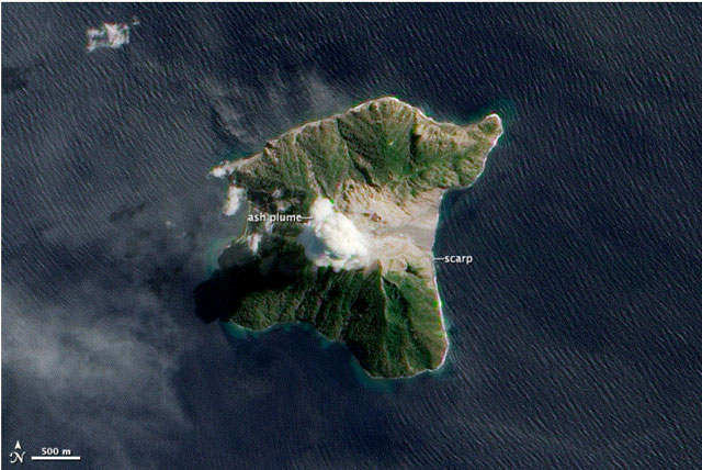 |
Figure 16. Batu Tara ash plume captured by the EO-1 satellite's ALI multispectral imager on 15 August 2012. A prominent scarp occurs on the E side of the ~2 km diameter island. Courtesy of NASA Earth Observatory. Image labeling and parts of the caption by Jesse Allen and Robert Simmon. |
During 24-29 November 2012, Volcano Discovery observers visited Batu Tara. They noted several strong episodic strombolian and a few vulcanian eruptions. On 25 November, effusive lava and bomb activity was observed ~500 m up the large E scarp of the stratovolcano (figure 17). Explosive eruptions occurred at irregular intervals ranging from 5-30 minutes. The Volcano Discovery observers noted frequent ash venting with minor amounts of incandescent material. At times, classic strombolian explosions ejected lava bombs to 100-300 m above the crater. Significantly more powerful blasts emitted liquid spatter several hundreds of meters in all directions. The latter eruptions created shock waves and loud detonation sounds. Ash plumes rose typically about 200-500 m, resulting in light ash fall on the W side of the island.
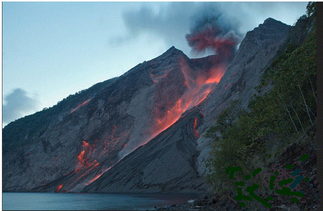 |
Figure 17. Strong strombolian explosion from the active crater of Batu Tara. Photo was taken ~1.2 km E of the crater on 25 Nov 2012. During phases of increased activity, more lava effused from the vent on the crater rim. Incandescent blocks rolled down the slope, looking similar to a lava flow. Courtesy of Volcano Discovery. Photo by Mark Szeglat. |
January-April 2014 ash plumes. The Darwin VAAC described ash emissions during the last week of March, late April, and mid-May 2014. Some plumes as high as ~ 3 km a.s.l. and one, during May, was visible for up to 75 laterally.
References. Sonnabend, H.R., 2007, Airlines, Aircrafts and Volcanic Ash, World Meterological Association (WMO) Fourth International Workshop on Volcanic Ash, Rotorua, New Zealand, 26-30 March 2007, report number VAWS/4 WP/07-04.
United Nations, Department of Humanitarian Affairs, 1992, Indonesia-Earthquake, DHA-UNDRO Information Report No. 2, 13 December, 1992; DHA-UNDRO 92/0817.
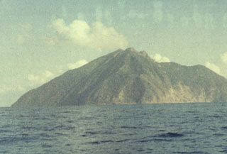
Geological Summary. The small isolated island of Batu Tara in the Flores Sea ~50 km N of Lembata (fomerly Lomblen) Island and the main volcanic arc. A scarp on the eastern side reaches the sea, and vegetation covers the other flanks to within 50 m of the summit. This volcano is noted for its potassic leucite-bearing basanitic and tephritic rocks. The first recorded eruption, during 1847-52, produced explosions and a lava flow.
Information Contacts: Darwin Volcanic Ash Advisory Centre (VAAC), Bureau of Meteorology, Northern Territory Regional Office, PO Box 40050, Casuarina, NT 0811, Australia (URL: http://www.bom.gov.au/info/vaac/); Volcano Discovery (URL: http://www.volcanodiscovery.com/home.html); and NASA Earth Observatory, NASA Goddard Space Flight Center (URL: http://earthobservatory.nasa.gov/).