Report on Santa Maria (Guatemala) — March 2014

Bulletin of the Global Volcanism Network, vol. 39, no. 3 (March 2014)
Managing Editor: Richard Wunderman.
Edited by Julie A. Herrick.
Santa Maria (Guatemala) Large May 2014 eruption with ashfall, pyroclastic flow, and lava flow; activity during October 2011-June 2014
Please cite this report as:
Global Volcanism Program, 2014. Report on Santa Maria (Guatemala) (Herrick, J.A., and Wunderman, R., eds.). Bulletin of the Global Volcanism Network, 39:3. Smithsonian Institution. https://doi.org/10.5479/si.GVP.BGVN201403-342030
Santa Maria
Guatemala
14.757°N, 91.552°W; summit elev. 3745 m
All times are local (unless otherwise noted)
This report summarizes activity from Santa María's active cone, Santiaguito, during October 2011-June 2014. Ash explosions, ashfall, and incandescent avalanches were observed throughout this time period. During the rainy season (April-September), lahars were frequently reported within the major drainages in the southern sector of the volcano. The sources for this report were Guatemala's Instituto Nacional de Sismologia, Vulcanologia, Meteorologia e Hidrologia (INSIVUMEH), Washington Volcanic Ash Advisory Center (VAAC), and Coordinadora Nacional para la Reducción de Desastres (CONRED).
Recurrent ash explosions. INSIVUMEH and the Washington VAAC reported frequent ash explosions from Santiaguito's active dome, Caliente, during October 2011-June 2014 (figure 35). Ash plumes were typically in the range of 500 m above the dome with exceptional cases in the range of 4,000 m, such as the explosive event on 9 May 2014. Significant ash plumes were known to drift as far as the Guatemala-Mexico border (such as activity during 5-6 November 2011 when ash extended 18-28 km SE of the summit). Degassing from the Caliente dome also generated frequent, diffuse, white plumes that rose to heights around 200 m above the summit.
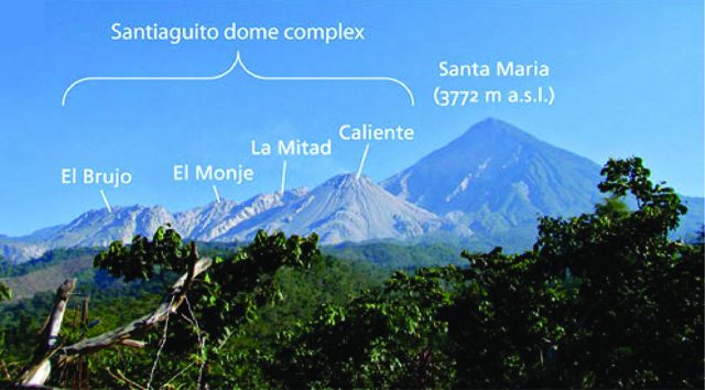 |
Figure 35. The Santiaguito dome complex of Santa María includes four major domes: El Brujo, El Monje, La Mitad, and Caliente (active since 1922). This photo was taken from the INSIVUMEH observatory located on Finca El Faro, ~6 km S of the active dome. Modified from Ball and others (2013). |
Ashfall from explosions and rumbling noises from explosions and avalanches were frequently reported in communities nearby (table 5). Following activity on 9 May 2014, ashfall triggered evacuations affecting ~130 people. CONRED and INSIVUMEH reported that ash had extended up to 20 km from the summit reaching the communities of Las Marías, San Marcos (10 km SW), Palajunoj (18 km SSW), El Faro (SW flank), La Florida (5 km S), Patzulín, and Quetzaltenango (18 km WNW).
Table 5. Ashfall from explosions at Santa María's active dome, Santiaguito, was reported in numerous communities during November 2011-June 2014. Courtesy of INSIVUMEH.
| Year | Date | Town reporting ashfall |
| 2011 | 2 Nov. | Las Marías, El Rosario (45 km SW), San Marcos (46 km NW), Palajunoj (SW), and San Felipe Retalhuleu (25 km SSE of the volcano) |
| 2012 | 19 Jan. | La Florida (5 km S), Palajunoj (SW flank), and San Marcos (46 km NW) |
| 27 Jan. | Monte Claro (S) and Palajunoj (SW) | |
| 1 Feb. | Monte Claro (S) and Palajunoj (SW) | |
| 2-3 Feb. | La Florida (5 km S), San Marcos (46 km NW), and Palajunoj (W) | |
| 23 Feb. | El Rosario (45 km SW), Monte Bello (S), Palajunoj (SW), and Quetzaltenango (18 km WNW) | |
| 27-28 Feb. | Monte Claro (S), San Marcos (46 km NW), Buena Vista (49 km NW), El Rosario, Monte Bello, and Palajunoj | |
| 11-12 Mar. | Observatory Vulcanológico de Santiaguito (OVSAN), the El Faro and Patzulín ranches, and in the village of Las Marías (SW) | |
| 8-9 Mar. | Loma Linda (W), San Marcos (10 km SW), and Palajunoj (W) | |
| 25-27 Mar. | Observatory Vulcanológico de Santiaguito (OVSAN), at the El Faro, La Florida, and Patzulín ranches (SW), and in the village of Santa María de Jesús (SE) | |
| 30 Apr.-1 May | Quetzaltenango (18 km WNW) | |
| 22 May | San Felipe (15 km SSW), El Nuevo Palmar (12 km SSW) | |
| 22 Jun. | Santa María de Jesús (SE) | |
| 1-3 Jul. | Ashfall was reported in La Florida (5 km S) and Monte Claro (S) | |
| 4-6 & 9-10 Jul. | La Florida (5 km S), Monte Claro (S), and Palajunoj (SW | |
| 18-20 Aug. | Monte Claro (S), El Rosario (45 km SW), Palajunoj (S), | |
| 25-26 Aug. | Monte Claro (S) | |
| 27 Aug. | San José (SE) | |
| 21 Nov. | Las Marías, Calaguaché (9 km S), and Nuevo Palmar (12 km S) | |
| 13-14 Dec. | La Florida (5 km S) and El Faro (SW flank) | |
| 2013 | 30 Jan. | Esperanza and San Mateo in Quetzaltenango |
| 7-8 & 10-11 Feb. | La Florida (5 km S) | |
| 23 Feb. | Quetzaltenango (18 km WNW) | |
| 22 Feb. | Monte Claro (S) | |
| 20-21 Feb. | Palajunoj (SW) and La Florida (5 km S) | |
| 6-11 Mar. | Calahuaché, El Faro (SW flank), and San José Patzulín (SW flank) | |
| 19 Mar. | San José (SE) | |
| 17-18 Mar. | Quetzaltenango (18 km WNW) | |
| 13-14 & 25-26 Mar. | El Faro (SW flank) and La Florida (5 km S) | |
| 29-30 Mar. | El Faro (SW flank) and La Florida (5 km S) | |
| 1-2 Apr. | San José (SE) | |
| 29 Apr. | San Jose, La Quina, and areas near Calahuaché (SE) | |
| 16 May | La Florida and Monte Claro (S) | |
| 30 May | Calahuaché village (SE) | |
| 9 Jun. | Monte Claro (S) | |
| 23 Jun. | Monte Claro (S) | |
| 27-28 Jun. | Monte Claro (S) and Finca La Florida (5 km S) | |
| 1 Aug. | Monte Claro (S) and La Florida (5 km S) | |
| 6 Aug. | Palajunoj area (S) | |
| 10 Aug. | Monte Claro (S) | |
| 27 Aug. | Palajunoj (S) | |
| 23 Aug. | Palajunoj region (S) | |
| 24 Sept. | Monte Claro (S) | |
| 2014 | 27-28 Jan. | Santa María de Jesús (SE) and the El Rosario Palajunoj finca |
| 13-14 Mar. | La Florida and Monte Claro (S) | |
| 14-15 Apr. | San Marcos (10 km SW), La Florida (5 km S), Rosario, and other areas in Palajunoj (18 km SSW) | |
| 9 May | Las Marías, San Marcos (10 km SW), Palajunoj (18 km SSW), El Faro (SW flank), La Florida (5 km S), Patzulín, and Quetzaltenango (18 km WNW) | |
| 11 May | San Marcos and the El Rosario Palajunoj finca | |
| 19-20 May | Monte Claro (S) | |
| 23 May | parts of Monte Claro (S) | |
| 2 Jun. | Monte Bello and Loma Linda (W) | |
| 19 Jun. | Parcelamiento Monte Claro (S of the summit) |
Avalanches and pyroclastic flows originating from Caliente dome were reported throughout late 2011 through June 2014 (table 6). A pyroclastic flow observed on 9 May 2014 traveled ~7 km from the active lava dome (figure 35). Approximately 1 million cubic meters of tephra was deposited within the Nimá I drainage. Secondary explosions occurred along the flowpath associated with hot deposits in contact with river water.
Table 6. A summary of significant pyroclastic flows from Santa María's Santiaguito occurred during February 2012-May 2014. Courtesy of INSIVUMEH.
| Year | Date | Direction |
| 2012 | 22-23 Feb. | upper flanks |
| 26 Mar. | W flank | |
| 29-31 Jul. | S flank | |
| 27-30 Nov. | upper flanks | |
| 2013 | 11-12 Mar. | SW,S,SE and E flanks |
| 27 Jun. | S flank | |
| 6 Aug. | S and SW flanks | |
| 7 Aug. | E, S, SW flanks | |
| 27 Aug. | extended down the SW flank | |
| 22 & 24 Aug. | portions of the SE rim collapsed and flows were directed S and SE | |
| 21 Sept. | restricted to the upper flanks | |
| 2014 | 23 Jan. | restricted to the upper flanks |
| 11 Feb. | directed NE | |
| 9 May | E and SE flanks and also channelized by the notch on the E flank |
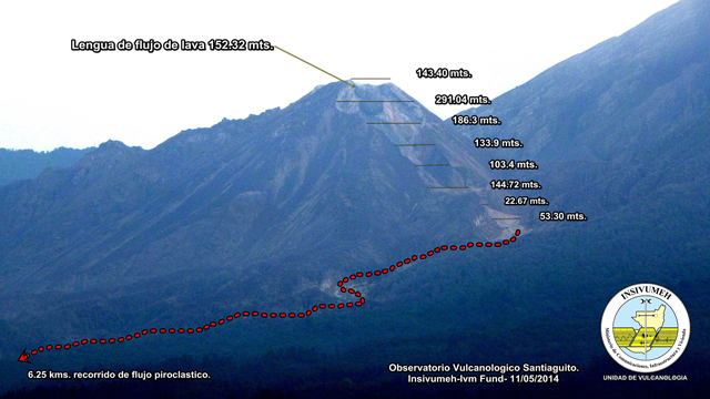 |
Figure 36. Looking approximately N toward Santa María's Santiaguito cone, this photo has been annotated to show surveyed distance measurements (in meters, here "mts.") measured along the slope between the summit and base of Santiaguito as well as the main pathway along the Nimá I drainage. The pyroclastic flow from 9 May 2014 traveled more than 6 km from the active dome (red dotted line). The length of the active lava flow on 11 May 2014 was 152 m. Courtesy of Gustavo Chigna, INSIVUMEH, and the International Volcano Monitoring Fund (IVM Fund). |
Lahars. During 2012-2014, lahars began flowing down Santa María's SE drainages during the onset of the rainy season (table 7). INSIVUMEH reported that many of these events were triggered by heavy rainfall and were frequently contained within the Nimá I drainage (figure 37). Lahars following the nearby rivers Nimá II, San Isidro, and Tambor and merged with the larger river, Samalá. These primary drainages are located S and SW of the active dome (see map in figure 28 of BGVN 24:03; note that Río San Isidro is an intermittent stream located between the Tambor and Nimá II rivers), three of which were included in a hazard map prepared by INSIVUMEH in collaboration with Japan International Cooperation Agency (JICA) in 2003 (figure 38). INSIVUMEH and CONRED released public announcements when Río Samalá was threatened by lahars (for example: 21 May 2012, 23 June 2012, and 6 June 2014) that included specific warnings for the Castillo de Armas bridge; the bridge supports the Interamerican Highway where it passes through the town of San Sebastián.
Table 7. During April 2012- June 2014, weak-to-strong flowing lahars were frequently triggered by heavy rainfall, mainly during April-September each year. Courtesy of INSIVUMEH.
| Year | Date | Drainages | Dimensions | Load | Notes | Damage/At risk |
| 2012 | 25 Apr. | Nimá II | na | 1.5 m diameter blocks; branches and tree trunks; sulfur odor | na | na |
| 21 May | Nimá II | na | 0.4 m diameter blocks; branches and tree trunks | moderate flow | threatened the Castillo Armas bridge and the river bend of El Niño | |
| 29 May | Nimá I & San Isidro | na | 1.5 m diameter blocks; branches and tree trunks; sulfur odor | hot material; moderate strength in Río Nimá I and weak in Río San Isidro; seismic station recorded the event | na | |
| 23 Jun. | Nimá I & San Isidro | na | 0.8 m diameter blocks; branches and tree trunks | moderate strength | threatened the Castillo Armas bridge and the river bend of El Niño | |
| 25 Jun. | Nimá I | na | na | weak strength | na | |
| 27 Jun. | Nimá I | 16 m wide; .9 m high | 0.8 m diameter blocks; sulfur odor | hot material; weak strength; seismic station recorded the event | na | |
| 4 Sept. | Nimá I & San Isidro | 30 m wide; 2 m high | 0.5 m diameter blocks; branches and tree trunks; sulfur odor | hot material; moderate strength; seismic station recorded the event | na | |
| 2013 | 1 Jun. | Nimá I | na | na | weak strength | na |
| 4 Jun. | Nimá I | 40 m wide; 2.5 m high | blocks | moderate flow | na | |
| 8 Jun. | Nimá I, Tambor, & Samalá | na | blocks | moderate flow | na | |
| 20 Jun. | Nimá I and Tambor | 30 m wide; 3 m high | 3 m diameter blocks; branches and tree trunks | moderate flow | na | |
| 11 Aug. | San Isidro, Tambor, & Samalá | 30 m wide; 1.5 m high | 1.5 m in diameter blocks; sulfur odor; branches and tree trunks and plants | hot material | vibrations were felt as the flow passed observers | |
| 31 Aug. | Nimá I | na | 2 m diameter blocks; branches and tree trunks | moderate flow | vibrations were felt as the flow passed observers; river banks were weakened after the flow and small avalanches occurred | |
| 5 Sept. | Nimá I | na | 1-2 m diameter blocks | na | river banks were weakened after the flow and small avalanches occurred | |
| 10 Sept. | Nimá I | 15 m wide; 6 m high | 3 m diameter blocks; sulfur odor | hot material; moderate flow | na | |
| 7 Oct. | Nimá I | 10 m wide; 1 m high | na | weak flow | na | |
| 2014 | 14 May | Nimá I | na | 2 m diameter blocks; branches and tree trunks | na | na |
| 18 May | Nimá I, San Isidro, & Tambor | 15 m wide; 2 m high | 1.5 m in diameter blocks; sulfur odor; branches of tree trunks and plants | hot material; moderate flow | vibrations were felt as the flow passed observers | |
| 22 May | Nimá I | 15 m wide; 2 m high | 1 m diameter blocks; sulfur odor; branches and tree trunks | hot material; moderate flow | na | |
| 24 May | Nimá I, San Isidro, & Tambor | 25 m wide; 2 m high | sulfur odor; branches and tree trunks | hot material; moderate flow | vibrations were felt as the flow passed observers | |
| 29 May | Nimá I, San Isidro, Tambor, & Samalá | 25 m wide; 3 m high | 0.5 and 2 m diameter blocks; sulfur odor; branches and tree trunks | hot material; strong flow | vibrations were felt as the flow passed observers | |
| 30 May | Nimá I & San Isidro | na | na | weak and moderate flow | in the afternoon and evening | |
| 1 Jun. | Nimá I, San Isidro, & Samalá | na | sulfur odor | hot material; strong flow | in the afternoon and evening | |
| 2 Jun. | Nimá I & San Isidro | na | na | moderate and strong flow | na | |
| 6 Jun. | Nimá I | 80 m wide; 5 and 9 m high in series | 5 m diameter | strong flow | emergency evacuation of Observatory staff; lost scientific equipment; damage to the Castillo Armas bridge | |
| 7 Jun. | Nimá I | 35 m wide | 1 m diameter blocks; sulfur odor | hot material; strong flow | na | |
| 8 Jun. | Nimá I | na | na | weak and moderate flow | na |
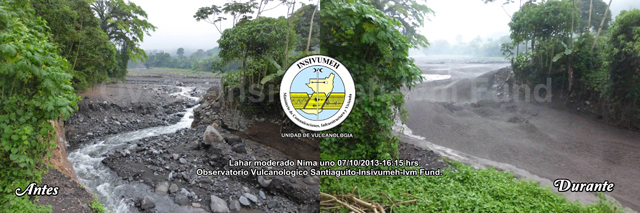 |
Figure 37. This set of two images of the Nimá I drainage shows a small-sized lahar that flowed from Santiaguito cone at 1615 on 7 October 2013 (left image was before (Antes); right image was during (Durante) the lahar flow). Looking upstream, this view is focused on a narrow section of Nimá I that was filled by a 12-m-wide and 1.5-m-high lahar. The rock wall on the right-hand side of the drainage (~3 m high) became a ramp for the lahar and was half-covered by the flow as the gray mass wrapped around the narrow corner in a fast and turbulent flow. Courtesy of Gustavo Chigna, INSIVUMEH and the IVM Fund. |
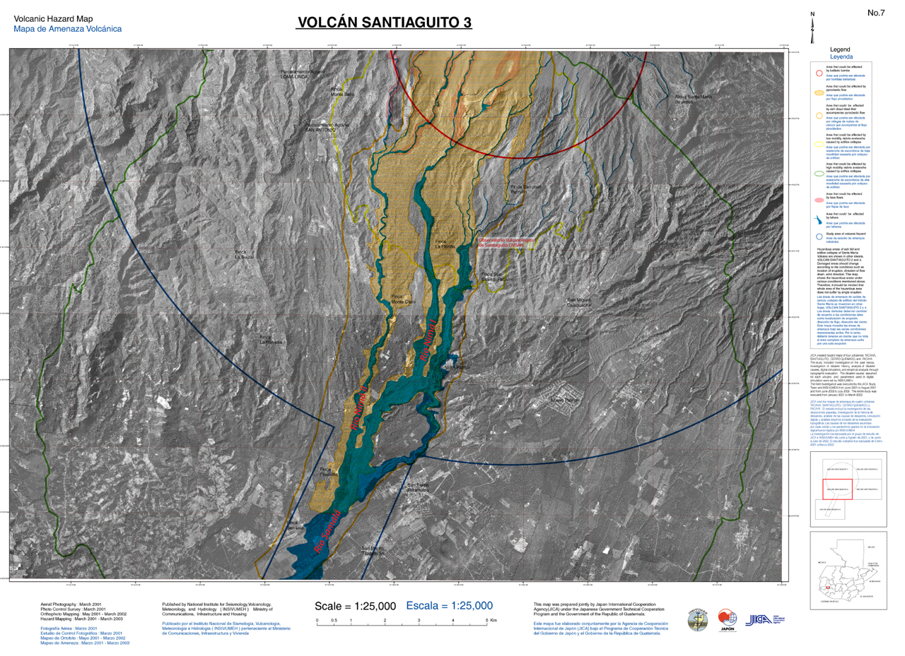 |
Figure 38. Volcanic hazard map (#3 of 5 published in a series) for Santa María focused on the region S of Santiaguito dome. The basemap is from 2001-2002 aerial survey photos and the hazard assessments conducted during 2001-2003 in collaboration with the Japan International Cooperation Agency (JICA). The three drainages (Río Nimá I, Río Nimá II, and Río Samalá labeled in red text) were added by GVP staff. Major towns, farms, and the INSIVUMEH observatory (OVSAN) are labeled; hazard zones are indicated with color coding; the blue semicircle and linear corridor indicates the extent of the study area; the area encompassed by the red semi-circle is at risk for volcanic ballistics. Other hazards include pyroclastic flows (orange shading), lava flows (pink), lahars (blue), ashfall (orange outline), and debris avalanches (yellow and green outlines). Courtesy of INSIVUMEH. |
The most damaging lahar during this reporting period occurred on 6 June 2014. The lahar flowed in pulses down the Nimá I drainage with crests 5-9 m high reaching a maximum width of 80 m. The Santiaguito Observatory (OVSAN) was forced to evacuate when the lahar overflowed the banks and spread across the facility grounds; important scientific equipment was damaged and also washed away. The lahar also flowed into a nearby farm.
Reference. Ball, J.L., Calder, E.S., Hubbard, B.E., and Bernstein, M.L., 2013, An assessment of hydrothermal alteration in the Santiaguito lava dome complex, Guatemala: implications for dome collapse hazards, Bulletin of Volcanology, 75:676.
Geological Summary. Symmetrical, forest-covered Santa María volcano is part of a chain of large stratovolcanoes that rise above the Pacific coastal plain of Guatemala. The sharp-topped, conical profile is cut on the SW flank by a 1.5-km-wide crater. The oval-shaped crater extends from just below the summit to the lower flank, and was formed during a catastrophic eruption in 1902. The renowned Plinian eruption of 1902 that devastated much of SW Guatemala followed a long repose period after construction of the large basaltic andesite stratovolcano. The massive dacitic Santiaguito lava-dome complex has been growing at the base of the 1902 crater since 1922. Compound dome growth at Santiaguito has occurred episodically from four vents, with activity progressing E towards the most recent, Caliente. Dome growth has been accompanied by almost continuous minor explosions, with periodic lava extrusion, larger explosions, pyroclastic flows, and lahars.
Information Contacts: Instituto Nacional de Sismologia, Vulcanologia, Meteorologia e Hydrologia (INSIVUMEH), Unit of Volcanology, Geologic Department of Investigation and Services, 7a Av. 14-57, Zona 13, Guatemala City, Guatemala (URL: http://www.insivumeh.gob.gt/inicio.html); Coordinadora Nacional para la Reducción de Desastres (CONRED), Av. Hincapié; 21-72, Zona 13, Guatemala City, Guatemala (URL: http://www.conred.org/); and Washington Volcanic Ash Advisory Center (VAAC), Satellite Analysis Branch (SAB), NOAA/NESDIS E/SP23, NOAA Science Center Room 401, 5200 Auth Rd, Camp Springs, MD 20748, USA (URL: http://www.ospo.noaa.gov/Products/atmosphere/vaac/).