Report on Bagana (Papua New Guinea) — June 2014

Bulletin of the Global Volcanism Network, vol. 39, no. 6 (June 2014)
Managing Editor: Richard Wunderman.
Bagana (Papua New Guinea) Eruption continues during 2011-2013; ash plumes and lava flows
Please cite this report as:
Global Volcanism Program, 2014. Report on Bagana (Papua New Guinea) (Wunderman, R., ed.). Bulletin of the Global Volcanism Network, 39:6. Smithsonian Institution. https://doi.org/10.5479/si.GVP.BGVN201406-255020
Bagana
Papua New Guinea
6.137°S, 155.196°E; summit elev. 1855 m
All times are local (unless otherwise noted)
Our last report discussed events at Bagana volcano into early 2011 (BGVN 36:01). One of the most active volcanoes in Papua New Guinea, in eruption since at least early 2000, Bagana is located on the mountainous spine of Bougainville Island. Bagana is far from cities and hard to reach due to the rough terrain (see location map in BGVN 33:11). Monitoring and reporting are often fragmentary and based on distant observers or satellite remote sensors (e.g., MODVOLC thermal alerts).
Bagana emits volcanic gases (primarily water vapor, carbon dioxide and sulfur dioxide) almost continuously, and frequently extrudes thick lava flows. According to Darwin Volcanic Ash Advisory Centre (VAAC) reports, ash plumes from Bagana since our last report in 2011 have ranged in altitude between about 2 and 4.3 km. Figure 12 shows satellite imagery of a recent lava flow on the Bagana's E flank.
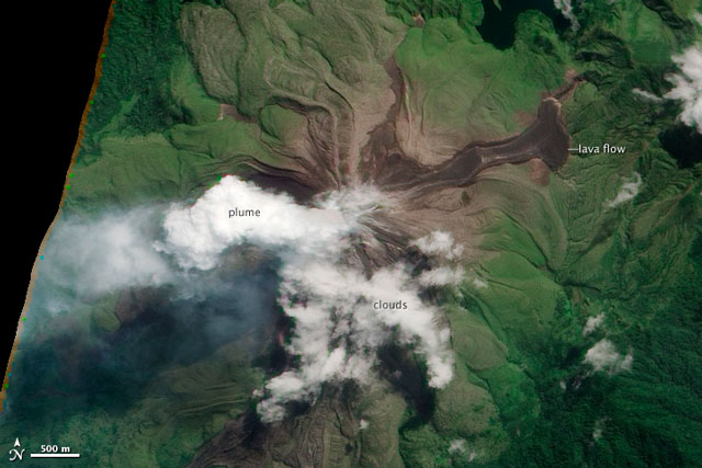 |
Figure 12. This natural-color image reveals a fresh lava flow on Bagana's E flank. The image was collected by the Advanced Land Imager (ALI) aboard the Earth Observing-1 (EO-1) satellite on 16 May 2012. Previous imagery from Landsat 7 showed that this lava flow was emplaced between March 2011 and February 2012. The fresh lava is dark brown. Older lava flows are covered in light green vegetation, and the surrounding forests are dark green. The plume and weather clouds are both white. NASA images by Jesse Allen and Robert Simmon using EO-1 ALI data; original caption by Robert Simmon. Courtesy of NASA Earth Observatory web site. |
The Papua New Guinea Department of Mineral Policy & Geohazards Management (DMPGM) reported that Bagana has been generally quiet since our previous report. Between March 2011 and February 2012, a lava flow occurred on the E flank (figure 12), and intermittent, weak emissions of thin to thick white vapor was observed. MODVOLC thermal alerts were frequent almost every month during the reporting period. Some geographical insight may serve toward a better understanding of the text below (figure 13).
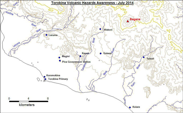 |
Figure 13. Topographic map showing the area around Bagana volcano. The map was prepared for a 1-month community awareness program conducted by the Rabaul Volcano Observatory and the Bagana Observer newspaper. The program was focused around the Torokina area but it also covered some areas in the S and E parts of Bougainville island. Courtesy of DMPGM. |
Rabaul Volcano Observatory (RVO) reported an ash eruption on 13 December 2012. Reports of light ashfall at Arawa (40 km SE of Bagana) were made, and a report of slightly thicker ashfall came from Manetai (~11 km E). No ashfall was reported at Torokina (SW).
The website Panaramio hosts several photos of Bagana taken in January 2013 looking from the W to SW. The images show a steep-sided cone with vigorous steaming coming from an extensive portion of the summit area (Tate, 2013).
During 6-12 August 2014, DMPGM reported increasing activity. Thin to thick white vapor plumes were accompanied on 6 and 8 August by reports of rockfalls. On 10 August, an ash plume rose to an estimated several hundred meters above the crater and drifted SW and W. Moderate ash was reported in Wakovi (6 km WSW), and residents were advised to evacuate to Gotana (~9 km SW of the summit) if ashfall continued. On 11 August, the Darwin VAAC reported ash plumes that rose to an altitude of 3 km and drifted up to 55 km SW. On 12 August, Darwin VAAC raised the Aviation Color Code to Red as ash plumes rose to an altitude of 7.6 km and drifted up to 167 km SW. It was lowered to Orange the next day. During 25-28 August, ash plumes rose 2.1-2.4 km in altitude.
Reference. Tate, Peter John, 2013, Two photos taken in the Autonomous Region of Bougainville, Papua New Guinea (S. Basious, photographer)(URL: http://www.panoramio.com/photo/86632789 and http://www.panoramio.com/photo/86632796); Panoramio-Google Maps (uploaded 26 February 2013; accessed September 2014).
Geological Summary. Bagana volcano, in a remote portion of central Bougainville Island, is frequently active. This massive symmetrical cone was largely constructed by an accumulation of viscous andesitic lava flows. The entire edifice could have been constructed in about 300 years at its present rate of lava production. Eruptive activity is characterized by non-explosive effusion of viscous lava that maintains a small lava dome in the summit crater, although occasional explosive activity produces pyroclastic flows. Lava flows with tongue-shaped lobes up to 50 m thick and prominent levees descend the flanks on all sides.
Information Contacts: Papua New Guinea Department of Mineral Policy & Geohazards Management (DMPGM), Port Moresby, Papua New Guinea; MODVOLC, Hawai'i Institute of Geophysics and Planetology (HIGP) Thermal Alerts System, School of Ocean and Earth Science and Technology (SOEST), Univ. of Hawai'i, 2525 Correa Road, Honolulu, HI 96822, USA (URL: http://modis.higp.hawaii.edu/); NASA Earth Observatory (URL: http://earthobservatory.nasa.gov/NaturalHazards); Darwin Volcanic Ash Advisory Centre (VAAC), Bureau of Meteorology, Northern Territory Regional Office, PO Box 40050, Casuarina, NT 0811, Australia (URL: http://www.bom.gov.au/info/vaac/); and Rabaul Volcano Observatory (RVO), PO Box 386, Rabaul, Papua New Guinea.