Report on Karkar (Papua New Guinea) — May 2015
Bulletin of the Global Volcanism Network, vol. 40, no. 5 (May 2015)
Managing Editor: Edward Venzke.
Research and preparation by Robert Andrews.
Karkar (Papua New Guinea) Ash plumes observed by satellites during 2012-2014
Please cite this report as:
Global Volcanism Program, 2015. Report on Karkar (Papua New Guinea) (Venzke, E., ed.). Bulletin of the Global Volcanism Network, 40:5. Smithsonian Institution. https://doi.org/10.5479/si.GVP.BGVN201505-251030
Karkar
Papua New Guinea
4.647°S, 145.976°E; summit elev. 1839 m
All times are local (unless otherwise noted)
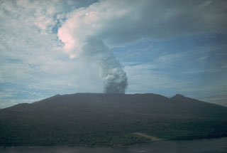
Plumes were recognized from Karkar volcano in early December 2009 and during February 2010, but it was ambiguous whether these were ash-bearing plumes (BGVN 35:05). Based on analyses of satellite imagery and wind data, the Darwin VAAC reported at least three periods with ash plumes during February 2012, January-March 2013, and March 2014 (table 1).
The 2012 plume noted during the early morning of 1 February (31 January UTC) was described as a "possible" ash plume as high as 10.7 km altitude by the VAAC, but was still seen in imagery about 6 hours later before being obscured by meteorological clouds. The 2013 activity consisted of plumes on three days across about six weeks, with the highest reaching 9.1 km altitude in late February. A low-level plume erupted mid-day on 26 March 2014 was also noted in imagery the following day. No other activity had been reported through May 2015.
Table 1. Volcanic plumes at Karkar observed in satellite imagery by Darwin VAAC, 2012-2015.
| Date | Event | Altitude (km) | Height (km) | Drift |
| 1 Feb 2012 | Ash plume (possible) | 7.6-10.7 | 5.8-8.9 | NE, E |
| 29 Jan 2013 | Ash plume | 4.3 | 2.5 | 40 km NE |
| 26 Feb 2013 | Ash plume | 9.1 | 7.3 | Not reported |
| 15 Mar 2013 | Ash plume | 8.5 | 6.7 | 75 km N, 130 km E |
| 26-27 Mar 2014 | Ash plumes | 2.4 | 0.6 | ~50 km ENE to NW |
Geological Summary. Karkar is a 19 x 25 km forest-covered island that is truncated by two nested summit calderas. The 5.5 km outer caldera was formed during one or more eruptions, the last of which occurred 9,000 years ago. The steep-walled 300-m-deep, 3.2 km diameter, inner caldera was formed sometime between 1,500 and 800 years ago. Cones are present on the N and S flanks of this basaltic-to-andesitic volcano; a linear array of small cones extends from the northern rim of the outer caldera nearly to the coast. Recorded eruptions date back to 1643 from Bagiai, a pyroclastic cone constructed within the inner caldera, the floor of which is covered by young, mostly unvegetated andesitic lava flows.
Information Contacts: Darwin Volcanic Ash Advisory Centre (VAAC), Bureau of Meteorology, Northern Territory Regional Office, PO Box 40050, Casuarina, NT 0811, Australia (URL: http://www.bom.gov.au/info/vaac/).

