Report on Santa Maria (Guatemala) — July 2015

Bulletin of the Global Volcanism Network, vol. 40, no. 7 (July 2015)
Managing Editor: Edward Venzke.
Edited by A. Elizabeth Crafford.
Santa Maria (Guatemala) New lava flow descends east flank of dome during June-December 2014; major lahar
Please cite this report as:
Global Volcanism Program, 2015. Report on Santa Maria (Guatemala) (Crafford, A.E., and Venzke, E., eds.). Bulletin of the Global Volcanism Network, 40:7. Smithsonian Institution. https://doi.org/10.5479/si.GVP.BGVN201507-342030
Santa Maria
Guatemala
14.757°N, 91.552°W; summit elev. 3745 m
All times are local (unless otherwise noted)
The dacitic Santiaguito lava-dome complex on the western flank of Santa Maria volcano has been growing since 1922. The youngest of the four domes in the complex, Caliente, has been actively erupting with ash explosions, lava flows, lahars, and pyroclastic eruptions for more than 40 years (figure 39). A substantial explosion on 9 May 2014 resulted in a 7-km-long pyroclastic flow and ashfall up to 20 km away (BGVN 39:03). This was followed in the next few weeks by a series of lahars in drainages on the south and east flanks of the dome that carried blocks as big as a meter in size. During late May and early June, repeated gas and ash plumes from smaller explosions continued to rise up to 700 m, and caused ashfall 10-15 km S and W. The rest of this report covers the time period June-December 2014 using information, unless otherwise noted, from the Instituto Nacional de Sismologia, Vulcanologia, Meteorologia e Hydrologia (INSIVUMEH).
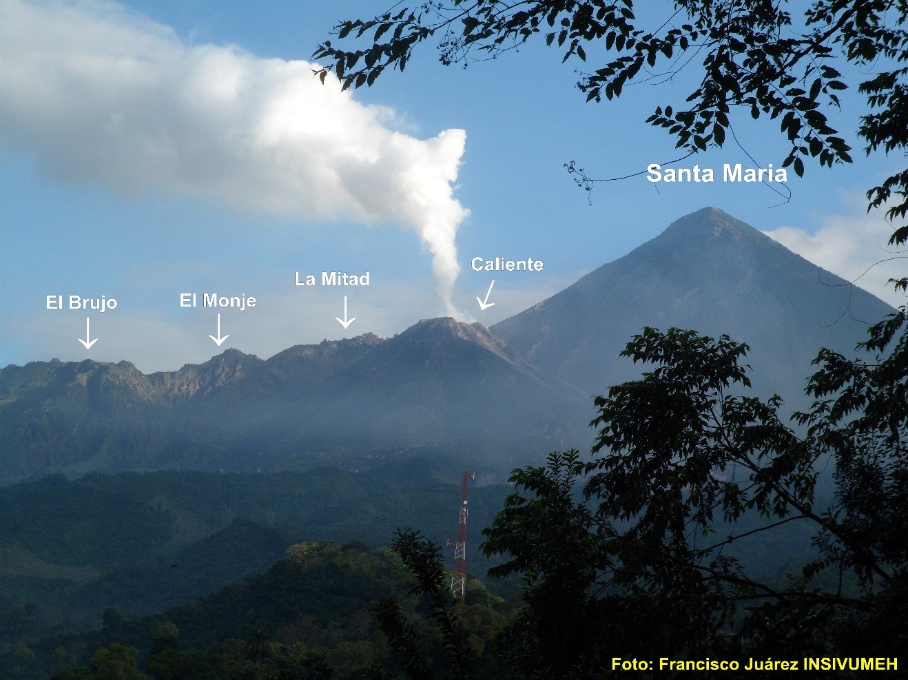 |
Figure 39. Santa Maria volcano and the Santiaguito dome complex. Photo by Francisco Juarez INSIVUMEH. |
The significant events at Santiaguito during the first half of 2014 included the slow growth of a lava flow from the east side of the Caliente vent that began during the 9 May explosion, and a major lahar in early June that did significant damage to equipment at the Santiaguito Observatory (OBSAN). Numerous smaller lahars, ash plumes, block avalanches from the lava flow, and minor ash fall in nearby villages were regular events. Other than degassing reported at Domo del Brujo on 9-10 June, all other events were related to activity from the Caliente vent.
Shortly after the 9 May 2014 eruption, a lava flow was observed slowly descending the E flank of the dome toward the Nimá 1 river drainage. By 11 May it was 152 m long (BGVN 39:03). As the slow-moving lava flow descended the E flank it generated hot block avalanches that sent debris into the Nimá 1 and San Isidro drainages. Incandescence from the flow was often visible at night. By the end of July the flow was 2.1 km long. In early August it moved into the Nimá 1 drainage. The avalanches at the flow front generated columns of fine ash that rose 100-200 m above the flow and drifted E. By mid-September the lava flow had traveled nearly 3.5 km from the summit, was 600 m wide, and was sending avalanche material down the Cabello de Ángel river drainage. By October the flow had slowed its advance, and phreatic explosions were observed from the middle and lower parts of the flow. In late October the more active part of the flow advanced farther southward down the Nimá 1 drainage, while a second flow advanced 3 km E toward the San Jose plantation. The flow continued with slow movement on both lobes for the rest of 2014, generating block avalanches, ash columns, and lahars in the drainages in front of the flow. The thermal signature from the flow was visible in MODIS satellite data (MODVOLC) from June through December.
On 6 June INSIVUMEH reported that the Santiaguito Observatory (OBSAN) was seriously affected by a large lahar that descended the Nimá I river drainage on the S flank of the Santiaguito lava-dome complex. The lahar came in waves, 5-9 m high, was 80 m wide, and carried blocks up to 5 m in diameter. It overtopped the river banks and flowed into a nearby farm. The staff working at OBSAN had to evacuate and some important scientific equipment was lost and damaged. The smaller lahars that regularly occurred during heavy rains throughout the second half of 2014 were generally 18-20 m wide and up to 2 m deep, carrying blocks up to a meter in diameter, tree trunks, and branches. They were most common in the Nimá 1 River drainage and its tributaries the Samala and the Cabello de Ángel, but also occurred on the Tambor River drainage and its tributary the San Isidro. The lahar on 15 July was large enough for INSIVUMEH to issue a warning that included the Castillo Armas bridge on the international highway NE of San Sebastián which crosses the Nimá 1 River 20 km SW of the volcano.
The Caliente vent generated ash plumes up to 500 m that generally drifted SW, with regular ash dispersion up to 1 km from the summit nearly every day during this period. Several times every month except for October, larger ash plumes also rose to 3.2 km (10,500 feet) usually accompanied by small explosions. Ash from these events generally drifted SW or S and deposited ash at Monte Claro farm and as far as Palajunoj, 19 km SW of the summit. Fumarolic activity and degassing with plumes rising to 3 km (10,000 feet) were reported virtually every week throughout the period.
Geological Summary. Symmetrical, forest-covered Santa María volcano is part of a chain of large stratovolcanoes that rise above the Pacific coastal plain of Guatemala. The sharp-topped, conical profile is cut on the SW flank by a 1.5-km-wide crater. The oval-shaped crater extends from just below the summit to the lower flank, and was formed during a catastrophic eruption in 1902. The renowned Plinian eruption of 1902 that devastated much of SW Guatemala followed a long repose period after construction of the large basaltic andesite stratovolcano. The massive dacitic Santiaguito lava-dome complex has been growing at the base of the 1902 crater since 1922. Compound dome growth at Santiaguito has occurred episodically from four vents, with activity progressing E towards the most recent, Caliente. Dome growth has been accompanied by almost continuous minor explosions, with periodic lava extrusion, larger explosions, pyroclastic flows, and lahars.
Information Contacts: Instituto Nacional de Sismologia, Vulcanologia, Meteorologia e Hydrologia (INSIVUMEH), Unit of Volcanology, Geologic Department of Investigation and Services, 7a Av. 14-57, Zona 13, Guatemala City, Guatemala (URL: http://www.insivumeh.gob.gt/inicio.html); Hawai''i Institute of Geophysics and Planetology (HIGP), MODVOLC Thermal Alerts System, School of Ocean and Earth Science and Technology (SOEST), Univ. of Hawai''i, 2525 Correa Road, Honolulu, HI 96822, USA (URL: http://modis.higp.hawaii.edu/)