Report on Colima (Mexico) — October 2015

Bulletin of the Global Volcanism Network, vol. 40, no. 10 (October 2015)
Managing Editor: Edward Venzke.
Edited by A. Elizabeth Crafford. Research and preparation by Stephanie Clair Martin.
Colima (Mexico) Explosive activity, lahars, pyroclastic and lava flows continue eruptive phase
Please cite this report as:
Global Volcanism Program, 2015. Report on Colima (Mexico) (Crafford, A.E., and Venzke, E., eds.). Bulletin of the Global Volcanism Network, 40:10. Smithsonian Institution. https://doi.org/10.5479/si.GVP.BGVN201510-341040
Colima
Mexico
19.514°N, 103.62°W; summit elev. 3850 m
All times are local (unless otherwise noted)
Eruptive activity at Mexico's Volcan de Colima in 2014 began with continued Vulcanian explosions that had started in January 2013 after 18 months of calm. Rockfall frequency was constant until early March, declined steadily through June 2014, increased again between July and September, and then tapered off once again through the end of the year. Explosion frequency also declined in March to a very low level by September, although the largest explosions (and pyroclastic flows they generated) occurred in the last quarter of 2014. Thirteen major lahars were recorded from two monitoring stations during the June through September rainy season; no damage was reported from these events. Three lava flows generating significant thermal anomalies formed on the WNW and SW flanks in September and November. By the end of 2014, the dome created in early 2013 had been destroyed by numerous explosive events. Information for this report comes primarily from geoscientists at the Colima Volcano Observatory and the Faculty of Science of Colima University, and also from the Washington Volcanic Advisory Center (VAAC), and the University of Hawaii MODVOLC thermal alert system.
Explosive activity. Between late January and May 2014 the Washington VAAC issued 10 reports of intermittent ash emissions due to explosive activity. The eight January through March events were reported in the previous Bulletin (BGVN 38:12). On 15 May, an ash emission rose to an altitude of 6.1 km. Another possible ash plume was observed on 18 May in satellite images drifting 30 km W. No additional ash plumes were reported by the VAAC until late November.
The year 2014 began with the continuation of high numbers of rockfalls (~150 per day), and a stable number of explosions (roughly 15-25 per day) (figure 110, top). Beginning in March 2014, they both began to decrease in number. By early July 2014, rockfalls reached their lowest number, and by September, almost no explosions were seismically recorded. Later in July 2014 the number of rockfalls abruptly increased, reaching a peak of 218 daily events on 16 September and then declined again through the end of December 2014.
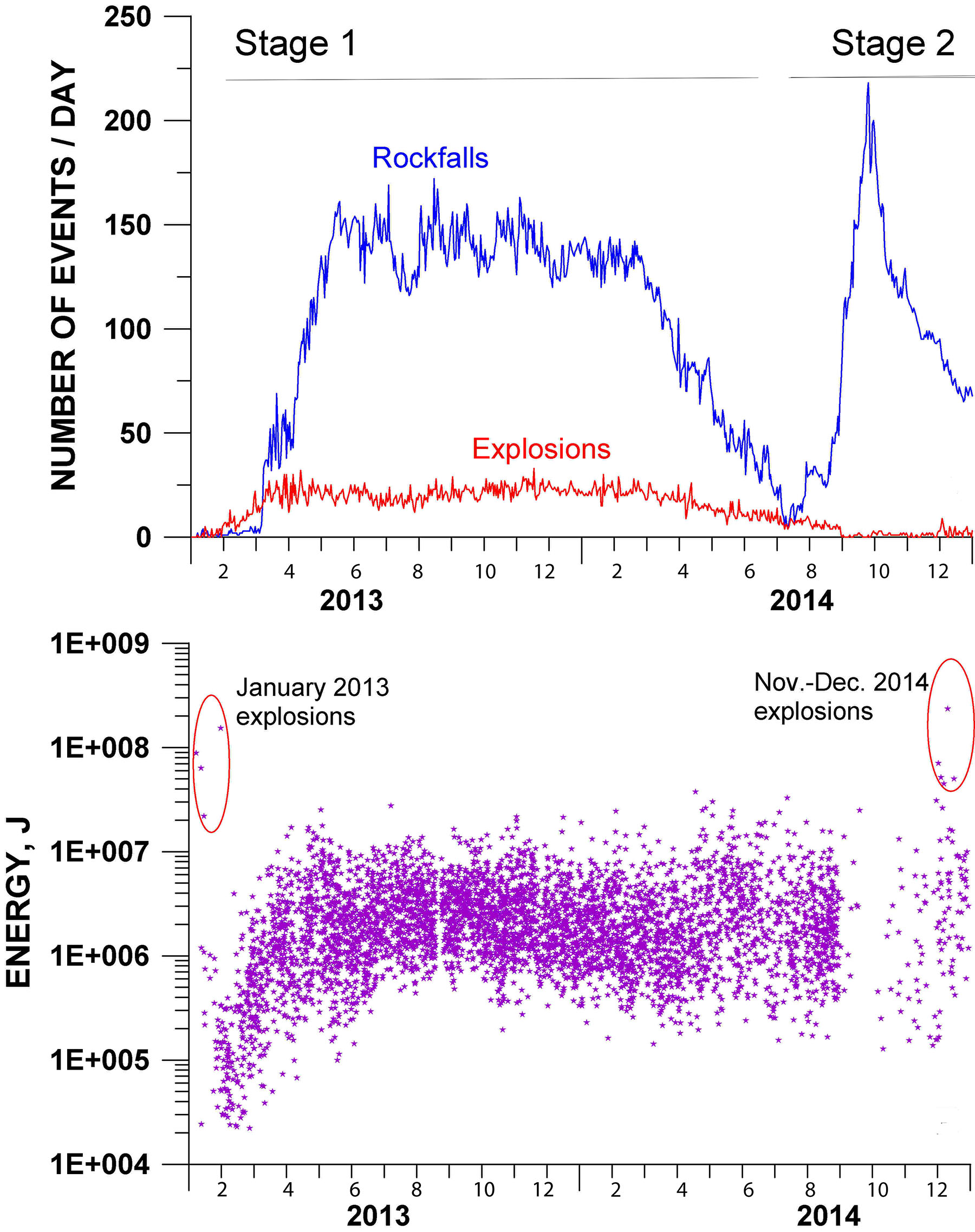 |
Figure 110. Overview of the seismicity recorded during the 2013-2014 eruption episode at Volcán de Colima. Upper plot: Daily variations in the number of rockfalls (blue line) and explosions (red line). Lower plot: Variations in the energy of explosive events; two sequences of more significant, higher-energy explosions in January 2013 and November-December 2014 are shown in ellipses. Courtesy of Centro Universitario de Estudios e Investigaciones de Vulcanología, Universidad de Colima. |
While the number of explosions decreased significantly from July to December 2014, the intensity of some of the larger explosions recorded during November-December was significant (figure 110, bottom). The largest event occurred during mid-December and measured over 2 x 10⁸ J. The energy of several explosions during November and December was comparable to the energy of the intermediate-size Vulcanian events observed at the beginning of the eruptive phase during January 2013.
MODVOLC thermal alerts showed only 8 pixels of thermal anomalies at Colima from January through 2 June 2014, suggesting that lava flows and explosions of incandescent material were intermittent and short-lived for the first part of the year.
Lahars. During June 2014, the second of two lahar monitoring stations began operation. It monitored a part of the volcano's S sector along the La Lumbre ravine. The first such monitoring station was installed in the Montegrande ravine in 2011. At both stations, the rainfall is measured and lahar detection is based on both visual and seismic records. Total rainfall recorded for the 2014 rainy season (from the end of June to September) was around 450 mm. During 2014 the lahars were concentrated mostly at the beginning of the rainy season (June-July), and the detected events were triggered by instances of ~20 mm of rain. Ten major lahars were recorded along the Montegrande ravine and three were recorded along the La Lumbre ravine during the 2014 rainy season (figure 111).
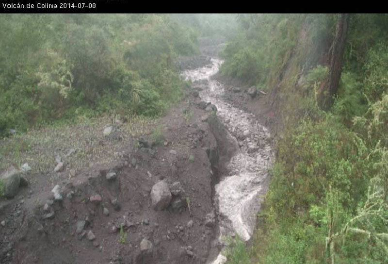 |
Figure 111. A surge in an advancing lahar at Colima that occurred on 7 July 2014 along the Montegrande ravine. The arrival of the surge appears mid-photo, evidenced as a block-rich, steepened front above the white apron of frothy water in the foreground. The lahar that contained this surge lasted more than one hour. Starting in June 2014, two drainages at Colima contained lahar-monitoring technology. Photo credit to Lucia Capra (Centro de Geosciencias, UNAM). |
Three of the recorded lahars were debris flows that contained block-rich fronts and were associated with events that lasted more than one hour. The other events were hyperconcentrated flood flows (less coherent than debris flows). The flood flows were common along the La Lumbre ravine which has a wider channel than the Montegrande ravine. The recorded lahars reached maximum distances of about 12 km, after which point they were diluted to stream flow. No damage was reported.
Lava flows. Two major lava flows associated with September 2014 explosions descended the WNW and SW flanks. The longest (on the SW flank) reached about 2.4 km (figure 112). Another pulse of magma occurred during November which produced a new flow on top of the earlier SW flow, significantly slowing its advance.
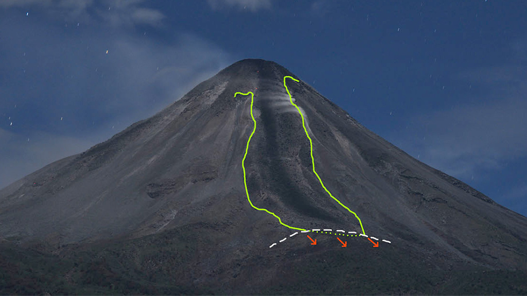 |
Figure 112. An annotated photo taken during the night of 7 November 2014 illustrating the path of the longest lava flow at Colima during September 2014, which descended the SW slope. The green lines indicates the flow's boundary. The dashed white line shows the location of topography near the end of flow. The direction of advance in November is shown with arrows. Courtesy of Facultad de Ciencias de la Universidad de Colima, photo by Nick Varley. |
The thermal signature from the lava flows and explosive activity in the 4th quarter of 2014 is very clear in MODVOLC data. Fourteen pixels in September, including five between 9 and 11 September on the SW flank (figure 113) likely show the lava flows described above and shown in figure 112. In addition, 66 pixels of thermal anomalies around the summit between 1 October and 1 January 2015 indicate strong, ongoing eruptive activity.
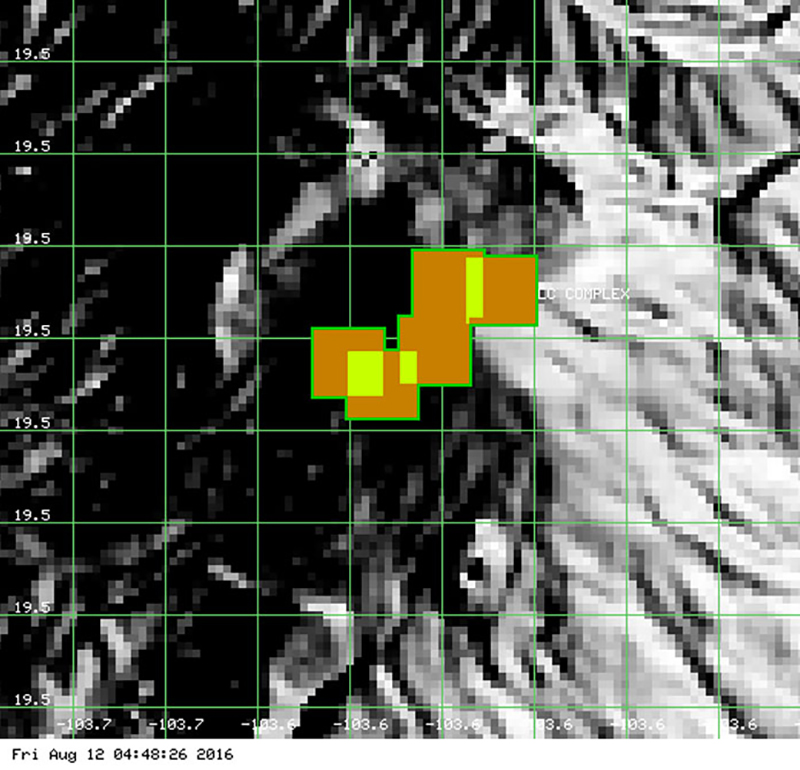 |
Figure 113. MODVOLC thermal signature from Colima for 9 to 11 September, 2014 showing thermal anomaly along SW flank corresponding to lava flow described in text. Image courtesy HIGP - MODVOLC Thermal Alerts System. |
Pyroclastic flows, ash plumes, and dome destruction. A strong explosion on 21 November 2014 produced a pyroclastic density current down the S flank which split into two ravines. The dilute part of the flow had an 8-m-high flow front and traveled 2.9 km along the Montegrande ravine. A denser part of the flow descended the San Antonio ravine and reached a distance of 3.1 km. Washington VAAC confirmed that this explosion produced a volcanic ash cloud that rose to 7 km and drifted 116 km ENE.
Another larger explosion was recorded the night of 30 November 2014 (figure 114). Based on satellite image analysis, the Washington VAAC reported an ash plume at 0300 local time (0800 UTC) that rose to 5 km and drifted 80 km NE, and a second smaller puff at 1540 local time that was below 4.9 km altitude and drifted 45 km E. Two additional plumes of ash were reported by the Washington VAAC in December. A plume on 4 December rose to 4.9 km as drifted a short distance SE, and another on 24 December rose to 6 km and drifted NE. Only a small amount of volcanic ash in the plume was reported by the Colima Volcanic Observatory from the 24 December event. The eruptive sequence of November-December 2014 destroyed the dome that originally formed near the beginning of this eruptive episode in 2013 (figure 115).
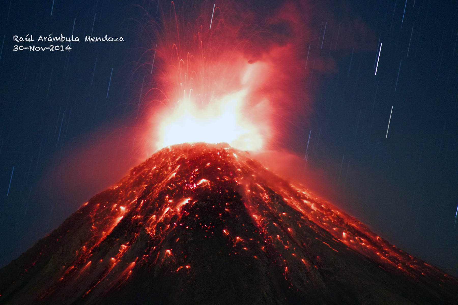 |
Figure 114. Colima's explosion on 30 November 2014. The resulting plume rose to ~5 km. Extended exposure taken at night by R. Arámbula-Mendoza (Centro Universitario de Estudios Vulcanologicos de la Universidad de Colima). |
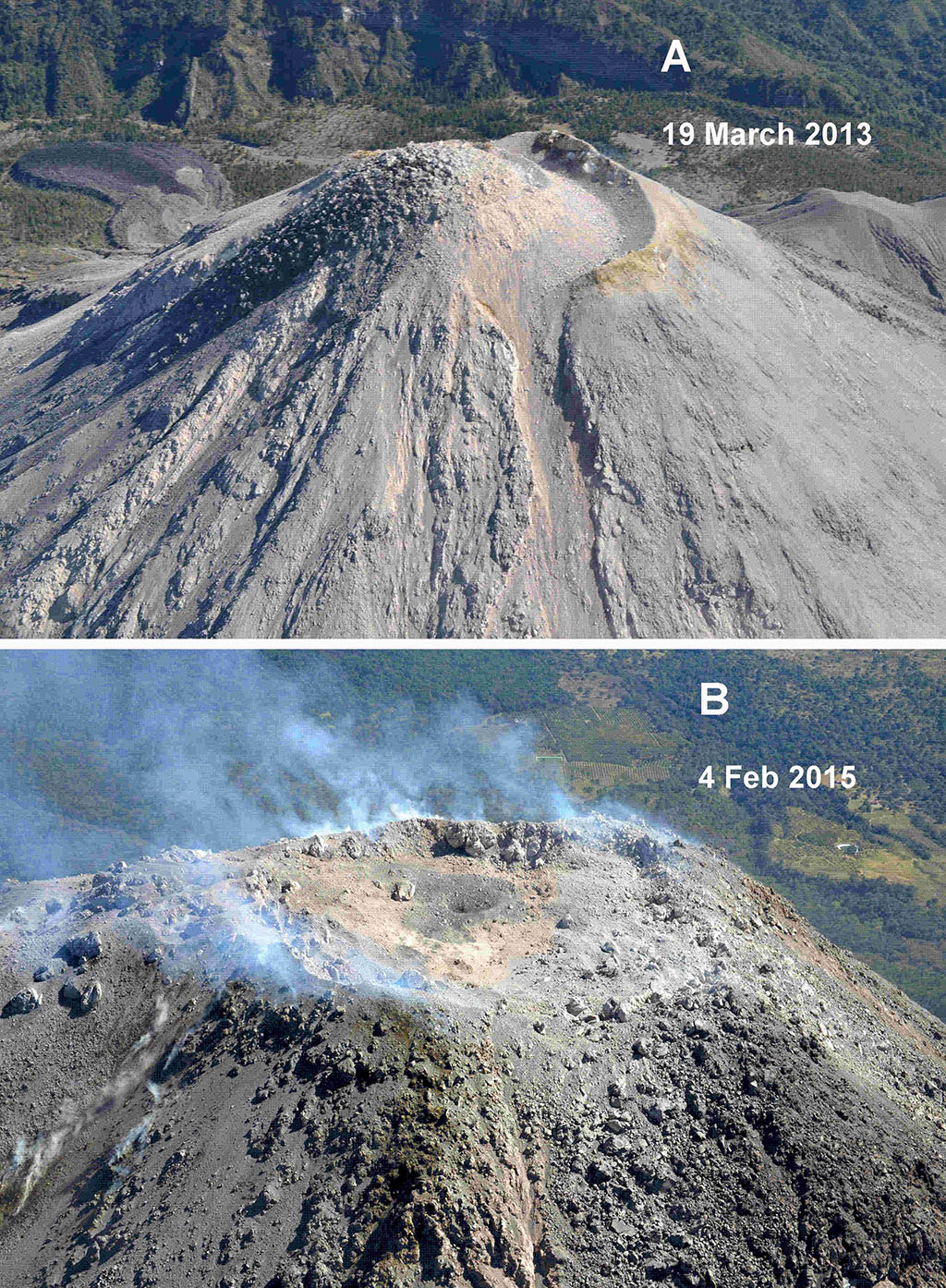 |
Figure 115. Colima's dome and crater area before (A) and after (B) dome destruction associated with the November-December 2014 eruptions. (A) Crater filled with lava dome on 19 March 2013, looking from SSW to NNE. The dome lavas spilling downslope were recorded as a high number of daily rockfall events. (B) Crater on 4 February 2015, looking from NNE to SSW. The summit dome area formed a depression with a nearly flat floor. Photo by Carlos Navarro Ochoa (Centro Universitario de Estudios Vulcanologicos de la Universidad de Colima). |
General Reference: Zobin, V. M., Arámbula, R., Bretón, M., Reyes, G., Plascencia, I., Navarro, C., Téllez, A., Campos, A., González, M., León, Z., Martinez, A, and Ramírez, C., 2015, Dynamics of the January 2013–June 2014 explosive-effusive episode in the eruption of Volcán de Colima, México: insights from seismic and video monitoring. Bulletin of Volcanology, v. 77, no. 4, p. 1-13. DOI: 10.1007/s00445-015-0917-z.
Geological Summary. The Colima complex is the most prominent volcanic center of the western Mexican Volcanic Belt. It consists of two southward-younging volcanoes, Nevado de Colima (the high point of the complex) on the north and the historically active Volcán de Colima at the south. A group of late-Pleistocene cinder cones is located on the floor of the Colima graben west and east of the complex. Volcán de Colima (also known as Volcán Fuego) is a youthful stratovolcano constructed within a 5-km-wide scarp, breached to the south, that has been the source of large debris avalanches. Major slope failures have occurred repeatedly from both the Nevado and Colima cones, producing thick debris-avalanche deposits on three sides of the complex. Frequent recorded eruptions date back to the 16th century. Occasional major explosive eruptions have destroyed the summit (most recently in 1913) and left a deep, steep-sided crater that was slowly refilled and then overtopped by lava dome growth.
Information Contacts: Observatorio Vulcanológico, Universidad de Colima, Colima, Col. 28045, Mexico; Centro Universitario de Estudios Vulcanologicos y Facultad de Ciencias de la Universidad de Colima, Avenida Universidad 333, Colima, Col., 28045 Mexico (URL: http://portal.ucol.mx/cueiv/); Washington Volcanic Ash Advisory Center (VAAC), Satellite Analysis Branch (SAB), NOAA/NESDIS E/SP23, NOAA Science Center Room 401, 5200 Auth Rd, Camp Springs, MD 20746, USA (URL: http://www.ospo.noaa.gov/Products/atmosphere/vaac/); Hawai'i Institute of Geophysics and Planetology (HIGP), MODVOLC Thermal Alerts System, School of Ocean and Earth Science and Technology (SOEST), Univ. of Hawai'i, 2525 Correa Road, Honolulu, HI 96822, USA (URL: http://modis.higp.hawaii.edu/)