Report on Lewotobi (Indonesia) — December 2015
Bulletin of the Global Volcanism Network, vol. 40, no. 12 (December 2015)
Managing Editor: Edward Venzke.
Research and preparation by Paul Berger.
Lewotobi (Indonesia) Occasional increases in seismicity and white plumes during August 2011-October 2015
Please cite this report as:
Global Volcanism Program, 2015. Report on Lewotobi (Indonesia) (Venzke, E., ed.). Bulletin of the Global Volcanism Network, 40:12. Smithsonian Institution. https://doi.org/10.5479/si.GVP.BGVN201512-264180
Lewotobi
Indonesia
8.542°S, 122.775°E; summit elev. 1703 m
All times are local (unless otherwise noted)
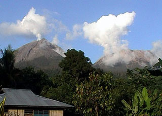
Lewotobi is composed of the Lewotobi Lakilaki (man) and Lewotobi Perempuan (woman) stratovolcanoes, with summit craters less than 2 km apart on Flores Island (figure 2). The last explosive eruption occurred in May 2003, accompanied by a high level of seismicity (BGVN 28:10). The volcano was apparently quiet through the middle of 2011, except for a brief period of unrest in May 2008 (BGVN 34:01) and March 2009 (BGVN 34:04). The report reviews activity through 7 October 2015, mostly from Pusat Vulkanologi dan Mitigasi Bencana Geologi (PVMBG) reports unless otherwise noted.
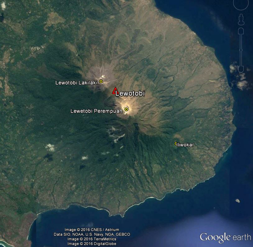 |
Figure 2. Satellite image from 4 September 2013 showing Lewotobi volcano and associated features on eastern Flores Island: the two stratovolcanoes Lakilaki and Perempuan, and SE flank cone Iliwokar. The crater on the smaller Lakilaki edifice to the NW is 400 m wide, while Perempuan's is 700 m wide. Courtesy of Google Earth; data labels provided by GVP. |
Seismicity increased during 26-31 August 2011, and plumes of "smoke" rose 15-50 m above the Perampuan crater rim. Based on the seismic data, the Alert Level for that crater was raised to 2 (Caution) (on a scale of 1-4) on 31 August. Increased seismicity and visual observations at Lakilaki after 17 September 2011 prompted PVMBG to raise the Alert Level to 2 for that cone as well on 22 September. Diffuse white plumes rose 15 m above the crater. At Alert Level 2 people are prohibited from going within a 1-km radius of the respective volcano.
Diffuse white plumes again rose 15-25 m above the summits of both craters during January-March 2012. Seismicity at both fluctuated, but had declined overall during September 2011-March 2012. The Alert Level at both was reduced from 2 to 1 (Normal) on 29 March 2012. Another period of increased seismicity on 28 September 2013 prompted PVMBG to again raise the Alert Level of Perempuan to 2.
Based on analysis of satellite images and wind data, the Darwin Volcanic Ash Advisory Centre (VAAC) reported that on 6 October 2014 a narrow, low-level ash plume from Lewotobi rose to an altitude of 3 km and drifted 185 km WNW. However, PVMBG did not report activity of any kind or raise the Alert Level. MODVOLC thermal alert pixels for that date showed a broad area on the E flank with 15 scattered anomalies extending to the shoreline, and three pixels the day before located just SE (figure 3). An alternate hypothesis is that fires spread NW due to prevailing winds, sending a low-level plume in that direction.
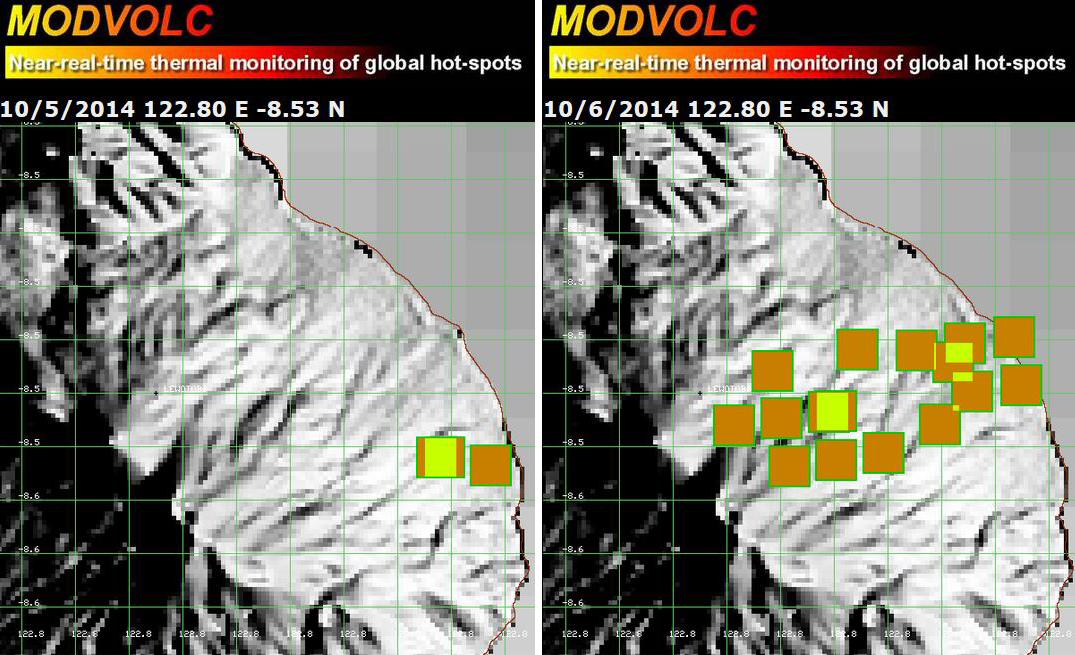 |
Figure 3. MODVOLC maps showing thermal alert pixels at Lewotobi on 5 October (left) and 6 October (right) 2014. Courtesy of Hawai'i Institute of Geophysics and Planetology (HIGP), MODVOLC Thermal Alerts System. |
White plumes were reported by PVMBG to be rising 15-20 m above Lakilaki during periods of clear weather from 1 February to 17 March 2015. Seismicity increased significantly on 13 March, especially the number of volcanic earthquakes and shallow volcanic earthquakes; harmonic tremor, tornillo events, and tectonic events were also detected. On 17 March the Alert Level was raised to 2. On 7 October 2015, PVMBG lowered the Alert Level to 1, based on visual observations and decreased seismicity over the previous three months.
Clear weather revealed white plumes rising 15 m above Perempuan during 17 July-25 August and 1 September-6 October 2015. Though the Alert Level had been raised on an unreported day, seismicity declined significantly after 1 August, and on 27 August, the Alert Level was lowered to 1.
Geological Summary. The Lewotobi edifice in eastern Flores Island is composed of the two adjacent Lewotobi Laki-laki and Lewotobi Perempuan stratovolcanoes (the "husband and wife"). Their summits are less than 2 km apart along a NW-SE line. The conical Laki-laki to the NW has been frequently active during the 19th and 20th centuries, while the taller and broader Perempuan has had observed eruptions in 1921 and 1935. Small lava domes have grown during the 20th century in both of the summit craters, which are open to the north. A prominent cone, Iliwokar, occurs on the E flank of Perampuan.
Information Contacts: Pusat Vulkanologi dan Mitigasi Bencana Geologi (PVMBG, also known as CVGHM, Center for Volcanology and Geological Hazard Mitigation), Jl. Diponegoro 57, Bandung, West Java, Indonesia, 40 122 (URL: http://www.vsi.esdm.go.id/); Darwin Volcanic Ash Advisory Centre (VAAC), Bureau of Meteorology, Northern Territory Regional Office, PO Box 40050, Casuarina, NT 0811, Australia (URL: http://www.bom.gov.au/info/vaac/); Hawai'i Institute of Geophysics and Planetology (HIGP), MODVOLC Thermal Alerts System, School of Ocean and Earth Science and Technology (SOEST), Univ. of Hawai'i, 2525 Correa Road, Honolulu, HI 96822, USA (URL: http://modis.higp.hawaii.edu/).