Report on Colima (Mexico) — January 2016

Bulletin of the Global Volcanism Network, vol. 41, no. 1 (January 2016)
Managing Editor: Edward Venzke.
Edited by A. Elizabeth Crafford.
Colima (Mexico) Large eruptions on 21 January and 10 July 2015; nearly constant eruptive activity all year
Please cite this report as:
Global Volcanism Program, 2016. Report on Colima (Mexico) (Crafford, A.E., and Venzke, E., eds.). Bulletin of the Global Volcanism Network, 41:1. Smithsonian Institution. https://doi.org/10.5479/si.GVP.BGVN201601-341040
Colima
Mexico
19.514°N, 103.62°W; summit elev. 3850 m
All times are local (unless otherwise noted)
Frequent historical eruptions at Mexico's Volcán de Colima (also known as Volcán Fuego) date back to the 16th century and include vulcanian and phreatic explosions, lava flows and large debris avalanches. An eruptive episode that began in 2013 with small explosions, rockfalls, lava flows and lahars continued through 2015. Information was provided by the airports in Mexico City and Colima, and pilot observations to the Washington VAAC (Volcanic Ash Advisory Center); the Unidad Estatal de Protección Civil de Colima (UEPCC) issued several bulletins during the year; and a web camera in Carrizalillo located 13 km SW of the volcano and managed by WebCams de Mexico captured numerous photographs and videos of the eruptive activity. There was also substantial coverage of the 2015 eruptions by major news outlets.
Explosive activity in 2015 was extensive, resulting in the Washington VAAC issuing 751 advisories during the year. The plumes reached heights over 7 km many times, and often reach distances of 150 or more kilometers away from the volcano. Two significant eruptions, on 21 January and 10 July, caused extensive ashfall, with a number of evacuations after the July event. In addition, lava flows were active down multiple flanks of the volcano, lava block avalanches were common, and pyroclastic flows were witnessed in July.
Colima began the year with an explosion on 3 January (reported by Informador.mx) that sent an ash plume to 3 km and caused ashfall in seven communities between 26 and 175 km NE, including the municipalities of Zapotlán El Grande (26 km NE), Concepción de Buenos Aires (63 km NE), Manzanilla de la Paz (72 km NE), Ayotlán (175 km NE), Poncitlán (122 km NE), Jamay (128 NE), and Tizapán (95 km NE). Additionally, the communities of Tuxpan (25 km ENE) and Zapotiltic (23 km NE) received repeated ashfall for much of January. On 21 January at 0713 another large explosion (figure 116) rose to 4 km and drifted NE again up to 78 km affecting the communities of Huescalpa (25 km NE), Tuxpan (25 km ENE), Zapotiltic (23 km NE), Atenquique (20 km E), and Mazamitla (78 km NE). MODVOLC showed that thermal anomalies occurred 18 times in January.
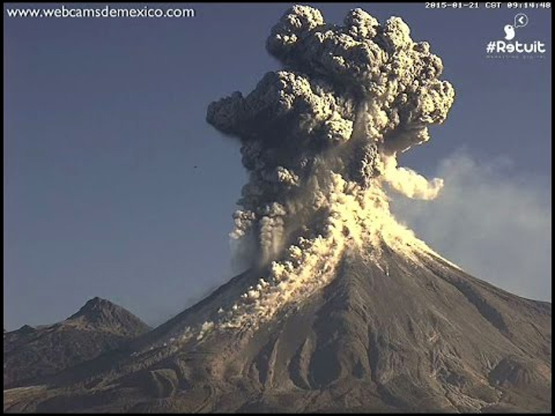 |
Figure 116. Webcam image of Volcan de Colima erupting on 21 January 2015. The webcam is located in Carrizalillo, 13 km SW. The ash plume rose to 4 km and spread ash up to 78 km NE; numerous lava block avalanches came down the flanks. A video of this eruption captured by the webcam can be viewed on the Webcams de Mexico YouTube channel. Courtesy of Webcams de Mexico. |
The UEPCC reported that lava flows were active on the W and WNW flanks on 24 January, and that the recent explosions had partially destroyed the lava dome. By 17 February they reported that a crater about 140 m in diameter had formed at the summit. Persistent ashfall in areas within 30 km of the volcano continued from multiple daily explosions through April. While most of the ash drifted NE or ENE, occasional plumes to the NW or SE were also reported. The Washington VAAC regularly reported plumes between 5.5 and 7.6 km in altitude during February through April. The highest plumes of 8.5 km were reported during the second half of April. The farthest drift of ash plumes were recorded in late February, observed on satellite images by Washington VAAC up to 370 km SE of the volcano. Persistent MODIS thermal anomalies (MODVOLC alerts) several times a week confirmed extensive activity during this time.
The frequency of ash plumes appeared to decrease from May through early July, with ash emissions generally recorded every few days instead of multiple times per day. Altitudes of plumes were 4.3-6.7 km, and the plumes traveled as far as 200 km E. Based on webcam views, the Washington VAAC reported an explosion on 18 June that ejected lava onto the flanks in addition to a probable ash emission. A 7 July UEPCC Bulletin noted that the lava dome had been growing rapidly the previous week, overtopping the crater rim and sending incandescent rock avalanches down the flanks. A gradual increase in the number of emissions and landslides was detected the following week, including pyroclastic flows that traveled up to 2.5 km down the N, W, and S flanks.
A large explosion on 10 July at 1200 sent an ash plume 7.6 km high which drifted 150 km W. Washington VAAC noted intense thermal anomalies and constant ash emissions throughout the day. Mexico's National Civil Protection Agency noted that activity increased that evening at 2017 and was characterized by incandescent material descending the WSW flanks, pyroclastic flows, and ash plumes that rose 4 km above the crater (7.8 km altitude) (figures 117 and 118). Significant ash fell in the communities of La Yerbabuena (8 km SW) (5-cm-thick ash deposits), San Antonio (12 km WSW), Carrizalillo (13 km SW), El Naranjal (12 km SW), and Suchitlán (18 km SSW) in Colima State. The Unidad Estatal de Protección Civil de Colima ordered La Yerbabuena and adjacent villages to evacuate, and some residents in nearby towns self-evacuated. A pyroclastic flow traveled 9 km S. By the next day ashfall was reported 30 km SW in Comala (26 km SW), Villa de Alvarez (30 km SW) and Colima (30 km SW), and the airport, El Aeropuerto Nacional de Colima, suspended operations due to ashfall.
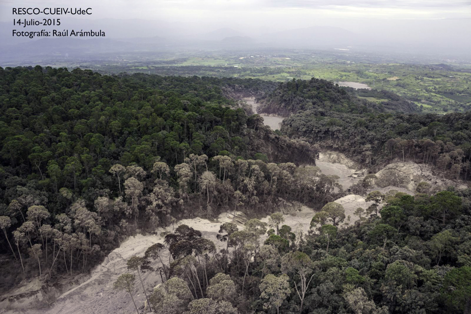 |
Figure 117. Pyroclastic flow deposits from the explosions at Colima on 10 and 11 July 2015. Photo by Raúl Arámbula taken on 14 July 2015, courtesy of Centro Universitario de Estudios e Investigaciones de Vulcanologia, Universidad de Colima (CUEIV-UdC). |
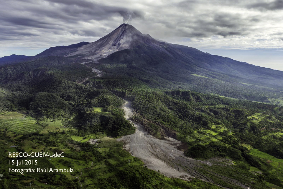 |
Figure 118. A pyroclastic flow traveled 9 km S from Colima on 10 July 2015. Additional pyroclastic flows and incandescent landslides formed during 11-12 July. Steam from the lava flow can be seen near the base of the flank. Photo by Raúl Arámbula, taken 15 July 2015, courtesy of Centro Universitario de Estudios e Investigaciones de Vulcanologia, Universidad de Colima (CUEIV-UdC). |
Ejected incandescent material, ash emissions, incandescent landslides, and pyroclastic flows continued at a moderate level during 11-12 July. Evacuations continued on 12 July, and ashfall persisted in Comala, Villa de Alvarez, and Colima. By 15 July, Washington VAAC reported that ash emissions had ceased, however, incandescent avalanches continued to descend the flanks. MODVOLC showed 54 thermal anomalies for July, confirming the extent of the eruptive activity.
Daily and multiple-daily ash plumes resumed at Colima on 31 July, and continued nearly every day through the end of the year. The ash plumes ranged from 4.2 to 7.6 km high and were observed drifting as far as 150 km away. The wind directions were more variable than earlier in the year, but the plumes drifted generally to the N and W. There were 15 MODVOLC thermal anomaly pixels in August, but only five more for the rest of the year. Three of these were on 14 and 19 December when plumes to 7.6 km were reported by the Washington VAAC.
The UEPCC reported that on 6 October scientists conducted an overflight of Colima and noted that the summit crater was 200 m wide and 50 m deep. Explosions had excavated parts of the crater, exposing the inner wall stratigraphy in the W and N parts of the crater. Fumarolic plumes rose from vents outside of the crater and from the SE interior. Weaker fumarolic activity was present in the NE and W sectors. An explosion on 5 October had produced a small pyroclastic flow that had traveled 2.1 km down the flanks.
Geological Summary. The Colima complex is the most prominent volcanic center of the western Mexican Volcanic Belt. It consists of two southward-younging volcanoes, Nevado de Colima (the high point of the complex) on the north and the historically active Volcán de Colima at the south. A group of late-Pleistocene cinder cones is located on the floor of the Colima graben west and east of the complex. Volcán de Colima (also known as Volcán Fuego) is a youthful stratovolcano constructed within a 5-km-wide scarp, breached to the south, that has been the source of large debris avalanches. Major slope failures have occurred repeatedly from both the Nevado and Colima cones, producing thick debris-avalanche deposits on three sides of the complex. Frequent recorded eruptions date back to the 16th century. Occasional major explosive eruptions have destroyed the summit (most recently in 1913) and left a deep, steep-sided crater that was slowly refilled and then overtopped by lava dome growth.
Information Contacts: Unidad Estatal de Protección Civil de Colima (UEPCC), Roberto Esperón 1170 Col. de los Trabajadores, C.P. 28020 (URL: http://www.proteccioncivil.col.gob.mx/); Washington Volcanic Ash Advisory Center (VAAC), Satellite Analysis Branch (SAB), NOAA/NESDIS E/SP23, NOAA Science Center Room 401, 5200 Auth Rd, Camp Springs, MD 20746, USA (URL: http://www.ospo.noaa.gov/Products/atmosphere/vaac/); Webcams de Mexico (URL: http://www.webcamsdemexico.com/); Informador.mx (URL: http://www.informador.com.mx/jalisco/2015/568514/6/volcan-colima-rocia-ceniza-sobre-siete-municipios.htm); Hawai'i Institute of Geophysics and Planetology (HIGP), MODVOLC Thermal Alerts System, School of Ocean and Earth Science and Technology (SOEST), Univ. of Hawai'i, 2525 Correa Road, Honolulu, HI 96822, USA (URL: http://modis.higp.hawaii.edu/); Centro Universitario de Estudios e Investigaciones de Vulcanologia, Universidad de Colima (CUEIV-UdC), Colima, Col. 28045, Mexico; Centro Universitario de Estudios Vulcanologicos y Facultad de Ciencias de la Universidad de Colima, Avenida Universidad 333, Colima, Col., 28045 Mexico (URL: http://portal.ucol.mx/cueiv/).