Report on Sirung (Indonesia) — February 2016
Bulletin of the Global Volcanism Network, vol. 41, no. 2 (February 2016)
Managing Editor: Edward Venzke.
Research and preparation by Robert Andrews.
Sirung (Indonesia) Small short-lived ash eruptions in May 2012 and July 2015
Please cite this report as:
Global Volcanism Program, 2016. Report on Sirung (Indonesia) (Venzke, E., ed.). Bulletin of the Global Volcanism Network, 41:2. Smithsonian Institution. https://doi.org/10.5479/si.GVP.BGVN201602-264270
Sirung
Indonesia
8.4972°S, 124.1306°E; summit elev. 1347 m
All times are local (unless otherwise noted)
Small eruptions from Sirung were reported in May 2012 and July 2015. These were the first reported eruptions since 1970 from the volcano at the southern end of Pantar island, which sometimes has a crater lake and a history of phreatic activity.
Activity during 2012. The Indonesian Centre for Volcanology and Geological Hazard Mitigation (CVGHM) reported that on 8 May 2012 a three-hour long ash eruption that was accompanied by loud sounds and incandescence material that reached 10 m above the crater. An ash plume rose 3.5 km above the crater and drifted N, causing ashfall up to 4 mm thick near the crater. During 9-12 May white plumes rose 30-50 m above the crater.
On 12 May an ash plume rose to an altitude of 3 km and drifted about 95 km SW, and a sulfur odor was reported in areas up to 3 km away. That same day CVGHM raised the Alert Level to 3 (on a scale of 1-4) and recommended that visitors not approach the volcano within a 2.5 km radius. During 13-18 May 2012 diffuse white plumes rose 10-50 m above the crater. Seismicity was elevated during 12-17 May then decreased through 23 May, although levels remained above background. On 25 May the Alert Level was lowered to 2 (on a scale of 1-4).
CVGHM reported that during 1-13 June 2012 diffuse white plumes rose 30-70 m above the crater. A sulfur odor was occasionally noted at the Sirung observation post. Based on seismic activity and visual observations, on 15 June CVGHM reiterated that the Alert Level remained at 2 (on a scale of 1-4). On 7 September 2012 the Alert Level was lowered from 2 to 1 (on a scale of 1-4).
Activity during 2015. Based on analyses of satellite imagery and wind data, the Darwin VAAC reported that on 7 July 2015 an ash plume from Sirung rose to an altitude of 1.5 km and drifted 85 km SW. On 8 July an ash plume at an altitude of 1.5 km drifted 55 km W.
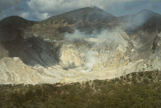
Geological Summary. Sirung is located at the NE end of a volcanic massif with multiple centers that extends 14 km NE from the southern end of Pantar Island. The volcano is truncated by a 2-km-wide caldera whose floor often contains one or more small lakes. Much of the volcano is constructed of basaltic lava flows, and the Gunung Sirung lava dome forms the high point on the caldera's western rim. A number of phreatic eruptions occurred from vents within the caldera during the 20th century. Forested Gunung Topaki, the high point of the volcanic chain, has a small summit crater and lies ~3.5 km SW of the active crater area.
Information Contacts: Pusat Vulkanologi dan Mitigasi Bencana Geologi (PVMBG, also known as Indonesian Center for Volcanology and Geological Hazard Mitigation, CVGHM), Jalan Diponegoro 57, Bandung 40122, Indonesia (URL: http://www.vsi.esdm.go.id/); Darwin Volcanic Ash Advisory Centre (VAAC), Bureau of Meteorology, Northern Territory Regional Office, PO Box 40050, Casuarina, NT 0811, Australia (URL: http://www.bom.gov.au/info/vaac/).