Report on Bagana (Papua New Guinea) — April 2016

Bulletin of the Global Volcanism Network, vol. 41, no. 4 (April 2016)
Managing Editor: Edward Venzke.
Edited by A. Elizabeth Crafford.
Bagana (Papua New Guinea) Ongoing ash plumes and thermal anomalies through early 2016
Please cite this report as:
Global Volcanism Program, 2016. Report on Bagana (Papua New Guinea) (Crafford, A.E., and Venzke, E., eds.). Bulletin of the Global Volcanism Network, 41:4. Smithsonian Institution. https://doi.org/10.5479/si.GVP.BGVN201604-255020
Bagana
Papua New Guinea
6.137°S, 155.196°E; summit elev. 1855 m
All times are local (unless otherwise noted)
Bagana is one of the most active volcanoes in Papua New Guinea, and has been in eruption since at least early 2000 (BGVN 39:06). It is monitored by the Rabaul Volcano Observatory (RVO) and the Darwin Volcanic Ash Advisory Centre (VAAC), though reports are often fragmentary and based on distant observers or satellite remote sensing. The last recorded lava flow was emplaced sometime between March 2011 and February 2012 (BGVN 39:06), and an ash plume on 10 August 2014 rose to 7.6 km altitude (BGVN 39:12). Intermittent ash plumes rising to 2.5 km were reported for the rest of 2014.
During January 2015 thru February 2016 there were no reports from RVO, so the primary data sources for activity at the volcano were Darwin VAAC, MODIS/MODVOLC, and MIROVA data. The volcano exhibited intermittent low level eruptive activity characterized by ash plumes and thermal anomalies, and was not quiet for more than a month at a time during this period.
During 20-21 January 2015, ash plumes to 3.7 km, drifting up to 35 km NE and SW, were reported by Darwin VAAC. MODVOLC thermal anomalies were also observed on 18 and 20 January. While no activity was recorded for February, there were continuous VAAC reports from 25 March through 1 April. The ash plumes were reported at 2-3 km altitude, and drifting 35-75 km N, NE, and SE. Only one thermal anomaly, on 16 March, was reported that month. Although no VAAC reports or MODVOLC thermal data were recorded in April and early May, MIROVA data (figure 17) indicated a low level of ongoing activity during this time.
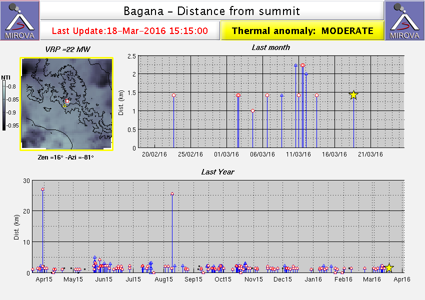 |
Figure 17. MIROVA data at Bagana for the period 1 April 2015 to 18 March 2016. Note continued intermittent activity within a few kilometers of the summit during this period. Intervals of increased activity in late May-early June, late September and late October 2015 correspond with VAAC reports and/or MODIS thermal data, confirming ongoing activity. Courtesy of MIROVA. |
Activity picked up again in late May 2015 with more extensive MODVOLC thermal anomalies of multiple pixels on 21 and 22 May, and then more intermittent data on 23, 24, 26, 28, 30 May and 2 June. The first VAAC report during this interval was on 27 May with a plume reported to 3 km, drifting 160 km NW. Additional thermal activity recorded on 4 and 6 June corroborates with VAAC reports from 3-5 June of an ash plume rising to 2.4 km and drifting 45-65 km SW. Numerous thermal anomalies were also recorded by MIROVA during early June.
Even though no more ash plumes were reported until September, thermal anomalies were recorded on 15 June, and 10, 15, and 19 July by MODVOLC, and also show intermittently in the MIROVA data during the late June through September window. September brought more reports of ash plumes on 23-24 and 26-27 and MODVOLC thermal anomalies on days 8, 15, 26 and 28. The ash plumes rose to 1.8 to 2.4 km and drifted 35-100 km N, NE, E, and SE.
While MODVOLC thermal anomalies were only recorded on 14 and 19 October, VAAC ash reports were issued three separate times, over 16-20, 24-26, and 29-30 October. None of the ash plumes rose higher than 2.4 km or drifted farther than 95 km; plumes went in all wind directions during these events. Although there were no more VAAC reports through February 2016, MODVOLC thermal anomalies on 20 November and 6 December 2015, as well as 7 and 23 January 2016 are all consistent with ongoing low level eruptive activity. These data are supported by MIROVA thermal anomalies during this time as well (figure 17).
Geological Summary. Bagana volcano, in a remote portion of central Bougainville Island, is frequently active. This massive symmetrical cone was largely constructed by an accumulation of viscous andesitic lava flows. The entire edifice could have been constructed in about 300 years at its present rate of lava production. Eruptive activity is characterized by non-explosive effusion of viscous lava that maintains a small lava dome in the summit crater, although occasional explosive activity produces pyroclastic flows. Lava flows with tongue-shaped lobes up to 50 m thick and prominent levees descend the flanks on all sides.
Information Contacts: Darwin Volcanic Ash Advisory Centre (VAAC), Bureau of Meteorology, Northern Territory Regional Office, PO Box 40050, Casuarina, NT 0811, Australia (URL: http://www.bom.gov.au/info/vaac/); Hawai'i Institute of Geophysics and Planetology (HIGP) MODVOLC Thermal Alerts System, School of Ocean and Earth Science and Technology (SOEST), Univ. of Hawai'i, 2525 Correa Road, Honolulu, HI 96822, USA (URL: http://modis.higp.hawaii.edu/); MIROVA, a collaborative project between the Universities of Turin and Florence (Italy) supported by the Centre for Volcanic Risk of the Italian Civil Protection Department (URL: http://www.mirovaweb.it/).