Report on Sinabung (Indonesia) — September 2016

Bulletin of the Global Volcanism Network, vol. 41, no. 9 (September 2016)
Managing Editor: Edward Venzke.
Research and preparation by Paul Berger.
Sinabung (Indonesia) Eruption that began in September 2013 continues during November 2015-April 2016
Please cite this report as:
Global Volcanism Program, 2016. Report on Sinabung (Indonesia) (Venzke, E., ed.). Bulletin of the Global Volcanism Network, 41:9. Smithsonian Institution. https://doi.org/10.5479/si.GVP.BGVN201609-261080
Sinabung
Indonesia
3.17°N, 98.392°E; summit elev. 2460 m
All times are local (unless otherwise noted)
The latest eruption of Sinabung began mid-September 2013 (BGVN 38:09). Since then, activity was persistent through October 2015 (BGVN 39:01, 39:10, 40:10, and 41:01). This report describes the continuing eruption from November 2015 through April 2016. Data were primarily drawn from reports issued by the Indonesian Center of Volcanology and Geological Hazard Mitigation (PVMBG, CVGHM), the Darwin Volcanic Ash Advisory Centre (VAAC), and the Badan Nacional Penanggulangan Bencana (National Disaster Management Authority, BNPB).
Inclement weather sometimes prevented visual observations, including the growing lava dome in the summit crater. Throughout the reporting period, the Alert Level remained at 4 (on a scale of 1-4), indicating that people within 7 km of the volcano on the SSE sector, and within 6 km in the ESE sector, should evacuate.
According to Darwin VAAC and PVMBG reports, a number of ash plumes were observed each month (table 5). They generally rose to altitudes of 3-4.5 km, although a few rose as high as 5.5 km; the summit is about 2.5 km. A pyroclastic flow on 8 November 2015 generated an ash plume, but clouds obscured its altitude.
Table 5. Ash plumes with altitudes and drift directions reported at Sinabung from November 2015 to April 2016. Weather clouds often prevented observations. Courtesy of PVMBG, Darwin VAAC, and BNPB.
| Date | Ash plume altitude (km) | Ash plume drift |
| 06 Nov 2015 | 4.6 | -- |
| 15-16 Nov 2015 | 3.7 | SW, E |
| 24 Nov 2015 | 3.3 | -- |
| 26 Nov 2015 | 4.3 | SW |
| 01 Dec 2015 | 3.4 | -- |
| 03 Dec 2015 | 3 | 35 km SE |
| 07 Dec 2015 | 3.7 | SW |
| 13 Dec 2015 | 4.3 | SW |
| 15 Dec 2015 | 4 | 75 km W |
| 16-22 Dec 2015 | 3.7-4.3 | SW, SE, E |
| 25 Dec 2015 | 3.4-4 | -- |
| 27-28 Dec 2015 | 3.4-4 | 10 km SW |
| 06-12 Jan 2016 | 3.7-4.3 | 15-40 km SW, W, NW, NE |
| 13-15, 17-19 Jan 2016 | 3.4-4.3 | NW, W, SW |
| 20-22, 25 Jan 2016 | 3-3.7 | NW, W, N |
| 30 Jan, 01-02 Feb 2016 | 3.7-4.3 | SW |
| 09 Feb 2016 | 3.7 | 40 km NW |
| 12 Feb 2016 | 3.4-5.2 | W, 30 km NE |
| 18, 20-23 Feb 2016 | 3-5.5 | 55 km S, SW, W, NW |
| 24 Feb-01 Mar 2016 | 3.6-4.3 | 45 km various |
| 02, 05-06 Mar 2016 | 3.6-4.3 | 55 km SE, SW, W |
| 09-10, 13-15 Mar 2016 | 3.6-4.9 | 25-55 km NW, W, SW |
| 16-19, 21-22 Mar 2016 | 2.7-4.9 | 65 km WSW, W, WNW, NW |
| 23-24, 27-29 Mar 2016 | 3.9-5.5 | 55 km NW, W, SW |
| 30 Mar-02 Apr, 04 Apr 2016 | 3.3-4.2 | W, NW |
| 06, 08-10, 12 Apr 2016 | 3.3-4.8 | SW, W, WNW |
| 14-16 Apr 2016 | 3.9-4.5 | NNW, NW, W |
| 20-21, 23-24, 26 Apr 2016 | 3.6-4.5 | 15-50 km SW, W, NW |
| 28-30 Apr 2016 | 3.6-4.2 | W, WSW |
PVMBG reported that, during 21-28 December 2015, as many as 21 hot avalanches and pyroclastic flows traveled 0.7-1.5 km ESE, producing ash plumes that rose 1 km. Ash plumes from explosions rose as high as 3 km and drifted E and SW. Seismicity consisted of avalanche and pyroclastic-flow signals, low-frequency and hybrid events, tremor, tectonic events, and volcanic earthquakes. Seismicity fluctuated at high levels, although it had declined compared to the previous week, and indicated lava-dome growth.
According to PVMBG, during 4-14 January 2016, as many as 192 hot avalanches and 12 pyroclastic flows traveled 0.5-3 km ESE (figure 27). Ash plumes from a total of 40 events rose as high as 3 km. Consistent with the previous month, seismicity fluctuated at high levels, although it had declined compared to the previous week.
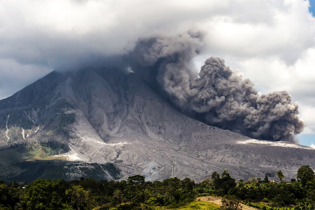 |
Figure 27. Photo showing a pyroclastic flow from Sinabung on 10 January 2016 as viewed from Berastepu Village (SE flank). Courtesy of Y.T Haryono/Anadolu Agency/Getty Images; from an Eruptions Blog article by Erik Klemetti in Wired. |
On 10 April 2016, BNPB reported that activity remained high, characterized by almost daily lava extrusion and pyroclastic flows, and high levels of seismicity. BNPB noted that 9,322 people (2,592 families) remained in 10 evacuation centers. Many families awaited relocation; 1,212 people had already been permanently relocated to new homes.
Thermal anomalies, based on MODIS satellite instruments analyzed using the MODVOLC algorithm, were observed seven days every month during November 2015-April 2016, except for six days in December and 12 days in January. Three pixels were observed on 25 December, 30 January, and 2 February; four pixels were observed on 12 November and 19 January; five pixels were observed on 23 January. The Mirova (Middle InfraRed Observation of Volcanic Activity) volcano hotspot detection system, also based on analysis of MODIS data, detected numerous hotspots every month during the reporting period.
Geological Summary. Gunung Sinabung is a Pleistocene-to-Holocene stratovolcano with many lava flows on its flanks. The migration of summit vents along a N-S line gives the summit crater complex an elongated form. The youngest crater of this conical andesitic-to-dacitic edifice is at the southern end of the four overlapping summit craters. The youngest deposit is a SE-flank pyroclastic flow 14C dated by Hendrasto et al. (2012) at 740-880 CE. An unconfirmed eruption was noted in 1881, and solfataric activity was seen at the summit and upper flanks in 1912. No confirmed historical eruptions were recorded prior to explosive eruptions during August-September 2010 that produced ash plumes to 5 km above the summit.
Information Contacts: Pusat Vulkanologi dan Mitigasi Bencana Geologi (PVMBG, also known as Indonesian Center for Volcanology and Geological Hazard Mitigation, CVGHM), Jalan Diponegoro 57, Bandung 40122, Indonesia (URL: http://www.vsi.esdm.go.id/); Darwin Volcanic Ash Advisory Centre (VAAC), Bureau of Meteorology, Northern Territory Regional Office, PO Box 40050, Casuarina, NT 0811, Australia (URL: http://www.bom.gov.au/info/vaac/); Badan Nasional Penanggulangan Bencana (BNPB), National Disaster Management Agency, Graha BNPB - Jl. Scout Kav.38, East Jakarta 13120, Indonesia (URL: http://www.bnpb.go.id/); Hawai'i Institute of Geophysics and Planetology (HIGP), MODVOLC Thermal Alerts System, School of Ocean and Earth Science and Technology (SOEST), Univ. of Hawai'i, 2525 Correa Road, Honolulu, HI 96822, USA (URL: http://modis.higp.hawaii.edu/, http://modis.higp.hawaii.edu/); MIROVA (Middle InfraRed Observation of Volcanic Activity), a collaborative project between the Universities of Turin and Florence (Italy) supported by the Centre for Volcanic Risk of the Italian Civil Protection Department (URL: http://www.mirovaweb.it/); Eruptions Blog, Wired Magazine (URL: https://www.wired.com/category/science/science-blogs/eruptions/).