Report on Santa Maria (Guatemala) — September 2016

Bulletin of the Global Volcanism Network, vol. 41, no. 9 (September 2016)
Managing Editor: Edward Venzke.
Edited by A. Elizabeth Crafford.
Santa Maria (Guatemala) Increased explosive activity, numerous pyroclastic flows from January through June 2016
Please cite this report as:
Global Volcanism Program, 2016. Report on Santa Maria (Guatemala) (Crafford, A.E., and Venzke, E., eds.). Bulletin of the Global Volcanism Network, 41:9. Smithsonian Institution. https://doi.org/10.5479/si.GVP.BGVN201609-342030
Santa Maria
Guatemala
14.757°N, 91.552°W; summit elev. 3745 m
All times are local (unless otherwise noted)
The dacitic Santiaguito lava-dome complex on the W flank of Guatemala's Santa Maria volcano has been growing since 1922. The youngest of the four vents in the complex, Caliente, has been actively erupting with ash explosions, pyroclastic flows, and lava flows for more than 40 years. This activity continued throughout 2015, with ash plumes rising up to 7 km altitude and drifting as far as 300 km from the volcano. The summit of the Caliente vent is about 2.5 km, and the summit of the volcano is about 3.7 km elevation. Communities within 20 km (mostly W, SW, and S) experienced near-constant minor ashfall, and active lava flows continued to migrate down the E side of Caliente. Pyroclastic flows and lahars also affected several areas in 2015. Guatemala's INSIVUMEH (Instituto Nacional de Sismologia, Vulcanologia, Meterologia e Hidrologia) and the Washington VAAC (Volcanic Ash Advisory Center) provided regular updates on the continuing activity during the first half of 2016 and are the sources for this report.
From January to June 2016, Caliente constantly emitted steam and bluish magmatic gases which rose 300-400 m above the crater. Major explosions with ash occurred in early February, April, May, and June 2016. The largest events of the last two years in terms of both frequency and size were recorded in April and May 2016. Ash plumes rose to 5 km altitude every month except March, and wind dispersed ash clouds as far as 500 km from the volcano; ashfall was reported regularly (several days every week) in villages within 20 km, and occasionally as far away as 60 km. Explosions sent several-meter-size bombs up to 3 km from the volcano. Pyroclastic flows descended drainages on several sides of Caliente, and contributed to collapses of the crater walls at the top of the cone. Lahars comprised of hot, SO2-rich ash and mud, and meter-size blocks traveled down the main drainages during May and June. MODIS infrared satellite data reported by both MODVOLC and MIROVA supported the physical evidence for heightened activity during this time.
Explosions in January 2016 were weak to moderate in size, causing ashfall in communities 10-20 km W and S. They averaged 10-20 per day, some sending one-meter-size blocks 200 m from the cone. On 20 January 2016 a pyroclastic flow from a loud explosion sent an ash cloud to 4.5 km altitude, and descended the S and SW sides of the cone (figure 41). The explosion was heard 10 km to the S. Ash plumes in January generally remained below 5 km altitude and drifted a few tens of kilometers from the summit in multiple directions.
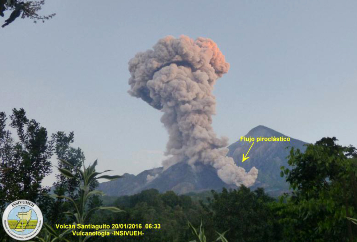 |
Figure 41. Ash explosion and pyroclastic flow at Santa Maria on 20 January 2016. The Washington VAAC reported the plume rising to 5 km altitude. Photo taken from the OVSAM observatory, 6 km SW of the Caliente vent. Courtesy of INSIVUMEH (January 2016 Santiaguito Report). |
Lava flows that began on 9 May 2014 and traveled several kilometers SE down the Nimá 1 and Cabello de Ángel (a tributary of the Nimá 1) drainages had ceased advancing by January 2016; the flows were up to 50 m thick in places and had cooled substantially (figure 42). Small avalanches, however, were reported from active lava flows close to the summit, and could be seen in satellite thermal images.
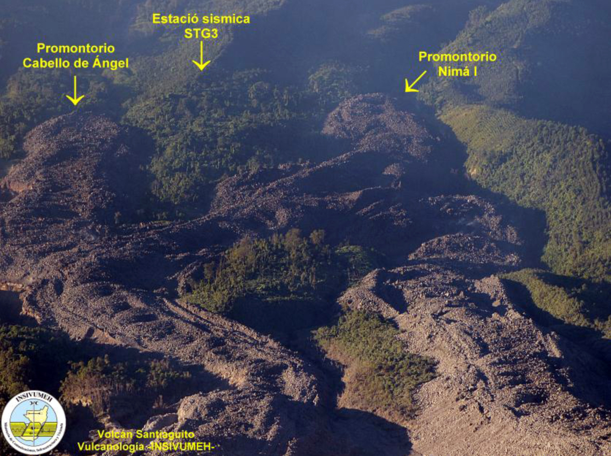 |
Figure 42. Lava flows at the Santiaguito complex of Santa Maria that came down the Nimá 1 and Cabello de Ángel river drainages in 2014 and 2015 had stopped moving by January 2016, leaving 50-m-high walls of lava in the drainages on either side of seismic station STG-3. Image is looking downhill to the south on the SE side of Caliente. The new lava flows are labelled, an older one is visible at the lower right. Compare with Google Earth image in BGVN 41:02 for a full view of the lava flow. Image was published in January 2016, but exact date is not given; it is likely from late 2015. Courtesy of INSIVUMEH (January 2016 Santiaguito Report). |
A large ash cloud reported by the Washington VAAC on 2 February 2016 rose to 6 km altitude and drifted over 500 km NNW before dissipating the next day. Ashfall was reported in the community of San Marcos 10 km SW and on the surrounding farms. A series of strong explosions beginning 7 February were heard up to 25 km away, and generated pyroclastic flows that descended the E and SE flanks; a dense ash cloud rose to 6 km altitude and drifted in several directions. Subsequent explosions in February had ash plume heights between 4 and 5.5 km and drifted a few tens of kilometers from the volcano.
In a special bulletin posted on 8 March, INSIVUMEH stated that a moderate explosion had caused additional collapse of part of Caliente cone, and a pyroclastic flow descended the NNE flank; the collapse also created a dense ash plume that covered the entire volcanic complex, and rose to 4 km altitude and drifted NNE. Activity diminished after this, and ash plumes remained under 5 km altitude, generally drifting less than 20 km from the cone before dissipating for the rest of March. Weak block avalanches continued down the E flank from a slowly advancing lava flow.
Major explosions and pyroclastic flows increased early in April and continued through June 2016. Plumes reported by the Washington VAAC rose to between 6 and 7.5 km altitude six times in April. Plumes emitted on 11 April drifted over 500 km SW before dissipating. Strong explosions on 3, 15, 19, and 23 April caused multiple pyroclastic flows which descended the E, SE, SW, and W flanks. During each of these events, parts of the crater rim collapsed, and mushroom-shaped ash clouds rose to between 4,000 and 5,000 m altitude, dispersing ash over the towns of Loma Linda, San Marcos, Las Marías, Palajunoj, and the neighboring farms, within 20 km SW of Santiaguito. Explosions during 19-22 April also ejected 2-3 m blocks up to 3 km from the cone.
In a special bulletin from 23 April, INSIVUMEH stated that a very high level of activity continued, and was the highest recorded in the previous two years. During the 23 April explosions, ash plumes that rose 4-5 km above the cone (6.5-7.5 km altitude) drifted 60 km W and NW, causing ashfall in the towns of Quetzaltenango (10 km N), Retalhuleu (30 km SW), and Mazatenango (25 km SSE). Abundant ash fell in communities within 20 km S and W of the volcano including San Marcos, Loma Linda, Palajunoj, Las Marías, El Palmar, and San Felipe Retalhuleu, and also the farms of Monte Bello, Monte Claro, El Faro, Patzulin, and La Florida. The pyroclastic flows of 23 April descended 3 km E and W down the Cabello de Ángel and San Isidro drainages.
INSIVUMEH reported a 2 May explosion with a plume that rose to 10 km altitude, significantly higher than most plumes from Santiaguito. It generated two pyroclastic flows which descended the E and W drainages. The Washington VAAC reported ash plumes from this explosion drifting nearly 500 km SW; they reported explosions with ash plumes rising to 6 km or higher 12 times during May. On 22 May, strong explosions generated dense ash plumes that drifted to the WSW and brought ashfall to Colomba (19 km WSW) and Coatepeque, more than 30 km WSW. Many of the communities within 20 km SW of the volcano such as San Felipe Retalhuleu, El Nuevo Palmar, Las Marías, and the farms of Loma Linda, San Marcos, Palajunoj, El Faro, La Florida, Patzulin, and El Patrocinio were also affected by ashfall. Pyroclastic flows traveled 2 km down the E, S, and W flanks and down the Cabello de Ángel and San Isidro drainages during these explosions (figure 43). INSIVUMEH noted that volcanic bombs were again ejected up to 3 km from the cone.
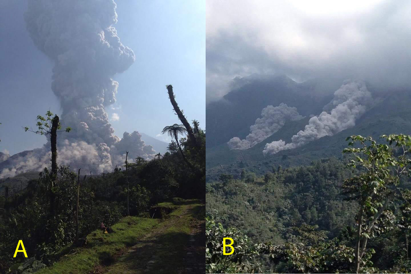 |
Figure 43. Ash explosion (A), and pyroclastic flows (B) which descended the Nimá 1 river drainage on the SE side of Caliente at Santa Maria on 22 May 2016. The Washington VAAC reported this plume at over 6 km altitude. Courtesy of INSIVUMEH (May 2016 Santiaguito report). |
In a special report posted on 25 May, INSIVUMEH noted continued energetic explosive activity at Caliente, with loud explosions and mushroom-shaped ash clouds that rose to 5 km altitude and drifted more than 40 km WSW. Ashfall was again noted in communities to the S and W. Pyroclastic flows traveled 2 km E, S, and W, in the San Isidro and Cabello de Ángel drainages.
The wind directions at Santiaguito are controlled by both the prevailing winds and the fact that the summit of Santa Maria (3.7 km) is over 1,000 m higher than the top of the summit crater at Caliente (2.5 km). Thus, the height of the explosion often determines the dispersion direction of the ash. Plumes that do not rise above the summit of Santa Maria generally disperse to the W or WSW as the prevailing wind is most often from the E, and ashfall is then observed in San Marcos (11 km SW) and surrounding villages and farms. When ash plumes exceed 3.8 km, the plume directions are much more variable. If the wind blows from the south, ashfall commonly reaches Quetzaltenango located 10-15 km to the N, whereas wind from the north will send the plume 30 km or more to the S or SW. It is thus not uncommon with large plumes that rise above 3.8 km to have wind dispersing ash in different directions at different altitudes (figure 44) at the same time. For example on 26 May, the Washington VAAC reported plumes at 5.2 km drifting 15 km SW while those at 6.4 km altitude were observed 70 km S.
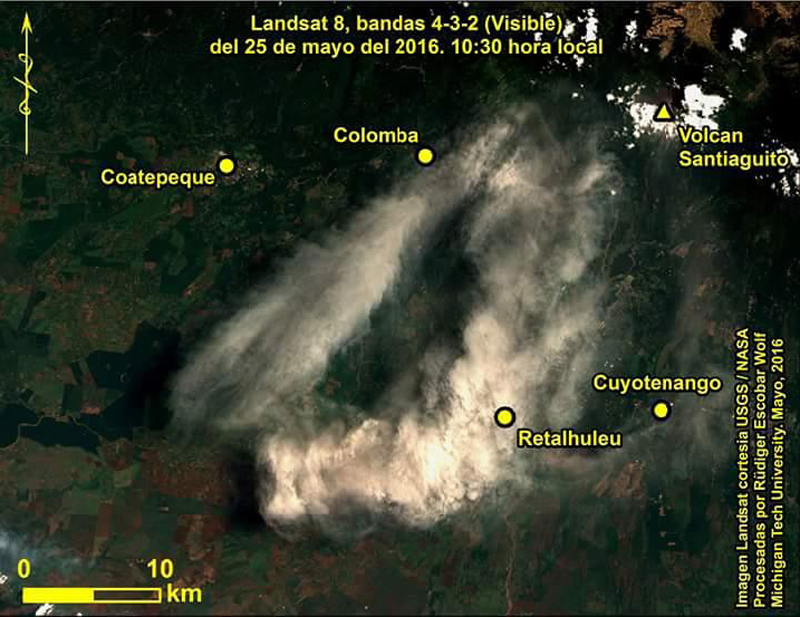 |
Figure 44. Landsat image of the ash cloud from Santa Maria dispersing more than 40 km in two directions, to the S and SW, on 25 May 2016. Courtesy of INSIVUMEH (May 2016 Santiaguito report) and USGS/NASA. |
Five strong explosions were recorded on 1, 17, 19, 20, and 29 June 2016; most were accompanied by pyroclastic flows down the sides of the cone. During the month, ash plumes at 5-6 km altitude were recorded numerous times, including plumes that drifted up to 100 km WSW into Mexican territory. Ashfall was reported in most communities up to 20 km away to the S and W after these events. A loud explosion on 20 June generated an ash plume containing lightning, and shock waves that were detected in areas within 15 km. A CONRED (Coordinadora Nacional para la Reducción de Desastres) report from 29 June noted that more than 60 moderate-to-large explosions had been detected through the end of June 2016, marking a very active period. The large volcanic bombs from these explosions traveled up to 3 km from the cone (figure 45).
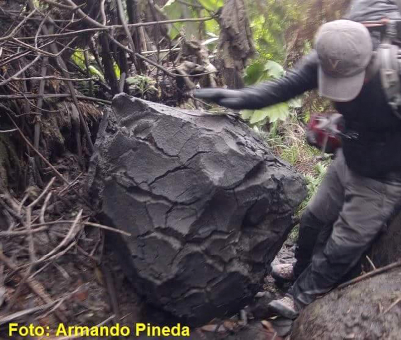 |
Figure 45. Bread-crust bomb about one meter in diameter located a few kilometers from the Caliente vent at Santa Maria on the tourist route, discovered in June 2016. Photo by Armando Pineda, courtesy of INSIVUMEH (June 2016 Santiaguito Report). |
Two lahars came down the rivers in May, and five moderate-to-large lahars were recorded in June. On 13 June the 30-m-wide lahar that went down the Nimá 1 drainage was hot and had a strong sulfur odor, and carried tree trunks, branches, and rocks 2-3 m in diameter (figure 46).
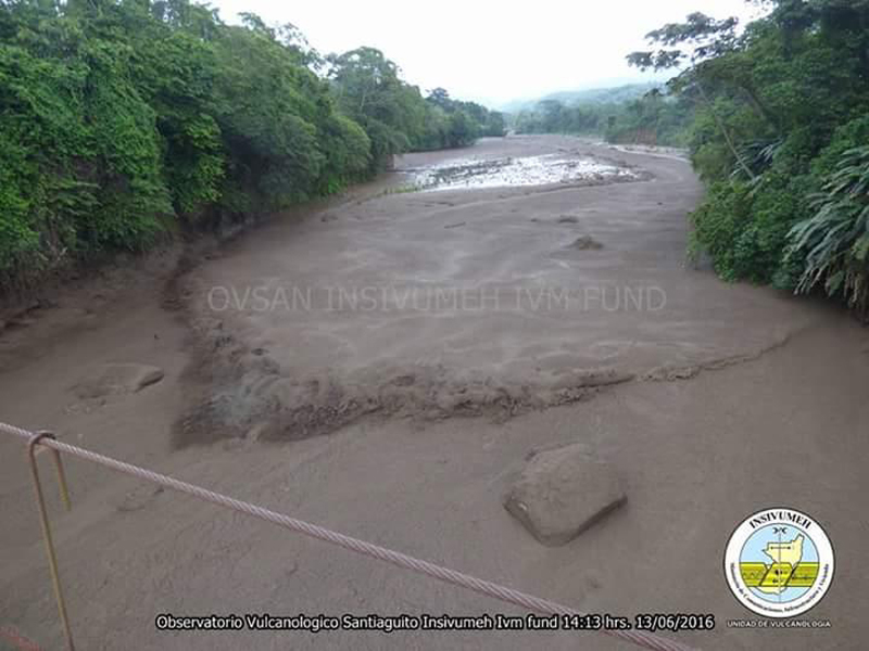 |
Figure 46. A powerful lahar descended the Nimá I river drainage at Santa Maria on 13 June 2016 with waves of hot, sulfur-smelling mud, and trees, branches, and blocks up to 3 m in diameter. Courtesy of INSIVUMEH and OVSAN (June 2016 Santiaguito Report). |
The MODVOLC thermal alert system mapped 20 pixels of anomalies from the MODIS infrared satellite data between January and June 2016. Three were in January, five in February (three on 27 February), seven were in April, (with five of those recorded on 20 April during a period of many large explosions reported by INSIVUMEH); five more were recorded in May. Heat emitted from flows around the cone and large, hot ash plumes and pyroclastic eruptions were the likely sources for the anomalies. The plot of the log Radiative Power at Santa Maria from the MIROVA system's analysis of the MODIS data agrees with the increase in activity reported during the first six months of 2016 by INSIVUMEH and the Washington VAAC (figure 47). MIROVA data indicate a period of increased radiative power that intensified in November 2015, and carried through to June 2016 before tapering off later in the year.
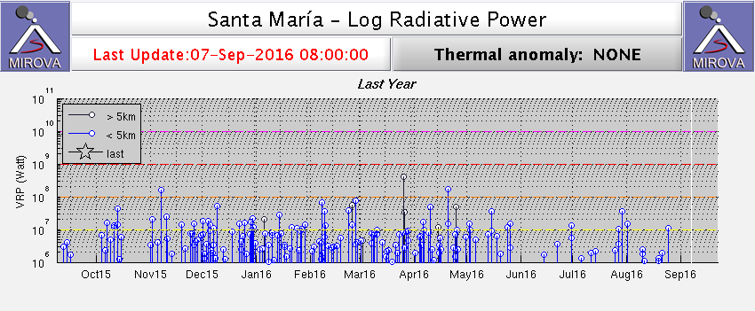 |
Figure 47. Increased VRP (Volcanic Radiative Power) at Santa Maria is evident in the MIROVA system coverage of the MODIS infrared satellite data from 7 September 2015 to 7 September 2016. Measurements of VRP between 107 and 108 watts were frequent between November 2015 and June 2016. Courtesy of MIROVA. |
Geological Summary. Symmetrical, forest-covered Santa María volcano is part of a chain of large stratovolcanoes that rise above the Pacific coastal plain of Guatemala. The sharp-topped, conical profile is cut on the SW flank by a 1.5-km-wide crater. The oval-shaped crater extends from just below the summit to the lower flank, and was formed during a catastrophic eruption in 1902. The renowned Plinian eruption of 1902 that devastated much of SW Guatemala followed a long repose period after construction of the large basaltic andesite stratovolcano. The massive dacitic Santiaguito lava-dome complex has been growing at the base of the 1902 crater since 1922. Compound dome growth at Santiaguito has occurred episodically from four vents, with activity progressing E towards the most recent, Caliente. Dome growth has been accompanied by almost continuous minor explosions, with periodic lava extrusion, larger explosions, pyroclastic flows, and lahars.
Information Contacts: Instituto Nacional de Sismologia, Vulcanologia, Meteorologia e Hydrologia (INSIVUMEH), Unit of Volcanology, Geologic Department of Investigation and Services, 7a Av. 14-57, Zona 13, Guatemala City, Guatemala (URL: http://www.insivumeh.gob.gt/); Washington Volcanic Ash Advisory Center (VAAC), Satellite Analysis Branch (SAB), NOAA/NESDIS OSPO, NOAA Science Center Room 401, 5200 Auth Rd, Camp Springs, MD 20746, USA (URL: http://www.ospo.noaa.gov/Products/atmosphere/vaac/) [Archive at http://www.ssd.noaa.gov/VAAC/archive.html]; Coordinadora Nacional para la Reducción de Desastres (CONRED), Av. Hincapié 21-72, Zona 13, Guatemala City, Guatemala (URL: http://conred.gob.gt/www/index.php?option=com_content&view=featured&Itemid=102); Hawai'i Institute of Geophysics and Planetology (HIGP), MODVOLC Thermal Alerts System, School of Ocean and Earth Science and Technology (SOEST), Univ. of Hawai'i, 2525 Correa Road, Honolulu, HI 96822, USA (URL: http://modis.higp.hawaii.edu/); MIROVA (Middle InfraRed Observation of Volcanic Activity), a collaborative project between the Universities of Turin and Florence (Italy) supported by the Centre for Volcanic Risk of the Italian Civil Protection Department (URL: http://www.mirovaweb.it/); USGS Landsat Data Access (URL: https://landsat.usgs.gov/landsat-data-access).