Report on Asamayama (Japan) — October 2016
Bulletin of the Global Volcanism Network, vol. 41, no. 10 (October 2016)
Managing Editor: Edward Venzke.
Research and preparation by Paul Berger.
Asamayama (Japan) Small explosions on 16 and 19 January 2015
Please cite this report as:
Global Volcanism Program, 2016. Report on Asamayama (Japan) (Venzke, E., ed.). Bulletin of the Global Volcanism Network, 41:10. Smithsonian Institution. https://doi.org/10.5479/si.GVP.BGVN201610-283110
Asamayama
Japan
36.406°N, 138.523°E; summit elev. 2568 m
All times are local (unless otherwise noted)
Asamayama (also known as Asama and Azumayama) has been relatively quiet since an eruption during January-February 2009 (BGVN 34:04, 35:10, and 37:10). This report discusses activity from the end of our previous report in October 2012 (BGVN 37:10) through September 2016. Data were provided by the Japan Meteorological Agency (JMA), which publishes monthly reports of Japanese volcanic activity. These reports have been translated into English since October 2010 and can be viewed online (see Information Contacts section below).
Based on JMA monthly reports, there was no exceptional activity during 2011-2013. However, during 2014, the frequency of shallow volcanic earthquakes and tremors occurring immediately under the summit crater began to increase. In late April 2015, volcanic seismicity further increased. Because of this increase in activity and the possibility of a small eruption, JMA raised the Alert Level on 11 June from 1 to 2 (on a scale of 5), and warned people not to approach the crater. The volcano remained in "a somewhat active state" in 2016 through at least September, and JMA kept the Alert Level at 2 through that time.
Very small eruptions were reported by JMA from the summit crater on 16 and 19 June 2015 that generated ashfall to the NE within 4 km of the crater. Scientists aboard an overflight later that day observed the crater venting white to blue-white gas. No further eruptions occurred through the end of December 2015.
JMA reported that the number of very weak volcanic earthquakes and tremors at a very shallow depth immediately under the summit crater had shown a long-term increasing trend since around 2014. The number began to increase further during late April 2015 and, although decreasing slightly since August, remained high through at least December.
On 14 October 2015, government scientists observed a thermal area around the bottom of the summit crater during an aerial inspection; this finding was similar to the previous observation on 24 June 2015. No new ejecta or discoloration were seen in or around the crater, and no changes in the crater morphology were observed.
According to JMA, white plumes rose as high as 700 m above the crater rim in November 2015 and 100-300 m above the rim in December. They also reported that between July and December 2015, weak night-time incandescence at the summit crater was visible.
The level of SO2 emissions rapidly increased from 200 metric tons/day on 1 June to 500 metric tons/day on 8 June, and then to 1,700 tons/day on 11 June 2015. The level remained high through at least the end of the year (table 3).
Table 3. Field survey data on SO2 levels (metric tons/day) by month, August-December 2015. Courtesy of JMA.
| Survey dates (2015) | SO2 level (t/d) |
| 3 August | 1,500 |
| 2 and 30 September | 600-1,900 |
| 8, 15, 26 October | 600-2,000 |
| 6, 24 November | 1,200 –1,700 |
| 2, 9, 22 December | 600-900 |
According to JMA, continuous Global Navigation Satellite System (GNSS) data had indicated that contraction had been occurring since the autumn of 2009. A slight extension was observed along some baselines from about May to September 2015. Contraction was also observed between the summit and Oiwake (8 km SSE) during June-September, based on electro-optical distance measurements. JMA interpreted this as possible inflation at shallow depths under the summit. Both methods indicated that contraction had ceased by October 2015. Tiltmeter data indicated that deeper parts under the western side of the summit had inflated slightly during early June; this trend slowed in late July and remained slow, but ongoing, through December 2015.
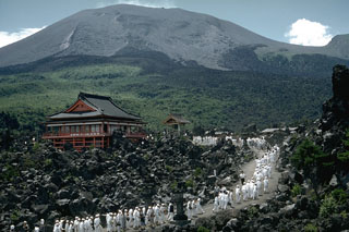
Geological Summary. Asamayama, Honshu's most active volcano, overlooks the resort town of Karuizawa, 140 km NW of Tokyo. The volcano is located at the junction of the Izu-Marianas and NE Japan volcanic arcs. The modern Maekake cone forms the summit and is situated east of the remnant of an older andesitic volcano, Kurofuyama, which was destroyed by a late-Pleistocene landslide about 20,000 years before present (BP). Growth of a dacitic shield volcano was accompanied by pumiceous pyroclastic flows, the largest of which occurred about 14,000-11,000 BP, and by growth of the Ko-Asamayama lava dome on the east flank. Maekake, capped by the Kamayama pyroclastic cone that forms the present summit, is probably only a few thousand years old and has observed activity dating back at least to the 11th century CE. Maekake has had several major Plinian eruptions, the last two of which occurred in 1108 (Asamayama's largest Holocene eruption) and 1783 CE.
Information Contacts: Japan Meteorological Agency (JMA), Otemachi, 1-3-4, Chiyoda-ku Tokyo 100-8122, Japan (URL: http://www.jma.go.jp/) [Monthly reports in English are at URL: http://www.data.jma.go.jp/svd/vois/data/tokyo/eng/volcano_activity/monthly.htm)].