Report on Ulawun (Papua New Guinea) — December 2016

Bulletin of the Global Volcanism Network, vol. 41, no. 12 (December 2016)
Managing Editor: Edward Venzke.
Research and preparation by Jackie Gluck.
Ulawun (Papua New Guinea) Intermittent ash plumes during eruptive periods in May 2012, November-December 2012, July-December 2013, and October-November 2016
Please cite this report as:
Global Volcanism Program, 2016. Report on Ulawun (Papua New Guinea) (Venzke, E., ed.). Bulletin of the Global Volcanism Network, 41:12. Smithsonian Institution. https://doi.org/10.5479/si.GVP.BGVN201612-252120
Ulawun
Papua New Guinea
5.05°S, 151.33°E; summit elev. 2334 m
All times are local (unless otherwise noted)
Ongoing seismicity and emissions were reported at Ulawun during May 2010-May 2011 (BGVN 36:05). Subsequent activity has been intermittent, with white, gray-brown, and gray ash plumes continuing to rise from the crater. RSAM values briefly rose as high as 650 units on 25 May 2012 and as high as 700 units on 15 July 2013. Eruptive activity with ash plumes occurred during May and November-December 2012, and July-December 2013. After almost three years without reports, ash plumes again rose from the crater during October and November 2016.
Activity during May 2012. The Rabaul Volcano Observatory (RVO) reported that during 1-6 and 10-26 May 2012 white plumes rose above the summit crater. However, gray-brown ash plumes rose from the crater during 7-9 and 27-31.
Seismicity was low during 1-6 May, consisting of discrete, low-frequency earthquakes. During this period RSAM values averaged ~25 units. Beginning at 1900 on 6 May RSAM values increased, reaching a peak of about 600 units at 0200 on 8 May, and then declined to ~250 units at 0100 on 9 May. Activity fluctuated between 250 and 430 units until 10 May, after which there was a further decline, reaching and remaining steady at a near-background level of ~50-70 units between 13-15 May. During 15-20 May seismicity included some discrete phases of moderate to strong tremor; RSAM values ranged between background and 200 units. RSAM values increased early on 20 May, and maintained an increasing trend with some fluctuation until reaching a peak of 650 on 25 May. After that the values declined again to 300, and fluctuated between 250 and 350 until the end of the month. The increased RSAM values reported above were associated with ongoing sporadic phases of volcanic tremors which had been going on since about March 2012.
Activity during November-December 2012. RVO reported that during 6-30 November pale-gray and brown ash plumes rose 200 m and drifted in multiple directions (figure 16). Ashfall was reported on the N and NW flanks, in Voluvolu, Noau, Ubili, and Ulamona (10 km NW). Low rumbling was heard on 18 November. A small landslide scar appeared near the N valley flank vent, reportedly caused by a large bolder and loose material sliding, triggered by a M 6.1 earthquake centered near Pomio (55 km SSE) on 19 November.
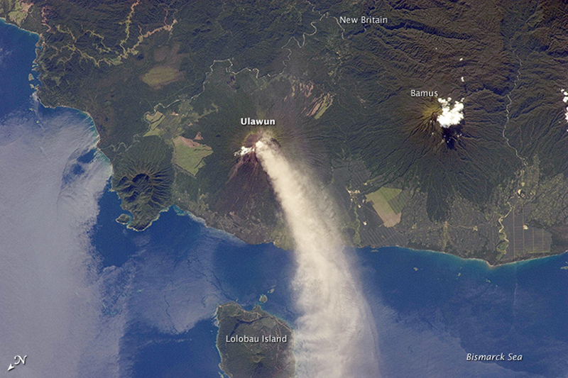 |
Figure 16. Photo of an eruption plume of white steam and brown ash from Ulawun on 30 November 2012. Note that the image is oriented with north towards the lower left, so the plume is extending from the summit crater towards the NW. The plume begins to broaden as it passes the SW coast of Lolobau Island, approximately 23 km downwind. The summit of Bamus volcano is obscured by non-volcanic white cumulus clouds (upper right). A large region of ocean surface highlighted by sunglint (sunlight reflecting off the water surface, lending it a mirror-like appearance) is visible to the NNE of Ulawun, beyond the breached Likuruanga crater (left). Photo by an Expedition 34 crew member on the International Space Station (image ISS034-E-0054960, original caption by William L. Stefanov, Jacobs/ESCG at NASA-JSC. Courtesy of NASA Earth Observatory. |
Dense, gray-brown ash plumes continued to rise to 200 m during 1-7 December. Ash fell on the NW flanks, in Ubili and Ulamona. Ash plumes ceased on 11 December, though variable amounts of white vapor plumes rose from the crater through the 16th.
Activity during July-December 2013. RVO reported low activity during 1-14 July 2013. Emissions from the summit crater consisted of white vapor during 1-7 July, and then changed to occasionally sub-continuous, light-gray ash clouds during 8 and 11-14 July. Ash clouds changed to a gray-brown color on 14 July.
Seismic activity was low from 1 July through the early part of 13 July, with RSAM values mostly near 50 units, though rises up to 100 units were recorded on 3 and 8 July. RSAM increased at around 0700 on 14 July, with the emergence of continuous volcanic tremor, and peaked at 700 units just after 0300 on 15 July. The report noted that the last significant volcanic tremors recorded at Ulawun were in May and June 2012.
RVO reported low activity during 4-31 August. Emissions from the summit crater consisted of white vapor until 16 August, and then changed to gray during 17-31 August. Emissions were more energetic on 24 August, rising to 200 m. A single booming noise and weak incandescence was also reported that day. RSAM values fluctuated but decreased overall.
Activity from 1 October to 31 December remained generally low. Between 1 October and 15 November small volumes of white vapor, and gray and gray-brown ash plumes rose 100 m above the crater and drifted S. Seismicity was low with RSAM values fluctuating between 100 and 150 units throughout the period. RVO reported that on most days during 16-30 November small volumes of gray to gray-brown ash plumes rose 100 m from the crater and drifted S. On 21 November ashfall was reported in Navo on the SW flank.
Based on analyses of satellite imagery, the Darwin VAAC reported that on 26 November an ash plume rose to an altitude of 3.7 km (1.4 km above the crater rim) and drifted 30 km NW.
During 1-15 December pale gray ash plumes rose from the crater. Residents between Sena Estate and Noau on the N flank reported ashfall in early December. Diffuse ash plumes rose from the crater during 15-21 December, and white vapor emissions were visible during 22-31 December. Seismicity was low, according to RVO reports. RSAM values generally fluctuated between 100 and 150 units throughout October-December, with a low of 60 on 20 December. No ash was reported after 21 December 2013.
Activity during October-November 2016. Ash plumes were once again reported by the Darwin VAAC starting on 11-12 October, based on satellite imagery and observations from RVO. The plumes rose to altitudes of 1.8-2.4 km and drifted 65 km WSW and W. RVO noted that there had been white plumes visible since 1 September. A report from officers at Hargy Palm Oil dated 13 October stated that a "minor eruption" had occurred after 1800 on 12 October, and that there were a few low noises from the volcano and nighttime glow during 12-13 October.
RVO noted that seismicity was at a low to moderate level, dominated by small low-frequency volcanic earthquakes. RSAM values increased and by mid-October were at the highest values (peak of 200) so far in 2016. The 12 October eruption was not evident in the seismic data.
Based on analyses of satellite imagery, the Darwin VAAC reported that during 16-17 October ash plumes rose to an altitude of 2.7 km and drifted SW and W. Additional ash plumes were seen during 19-21 and 23-28 October to altitudes of 2.4-3 km drifting 25-110 km NW, W, NE, and SW.
Despite the ash plumes extending far downwind, RVO reported that during 16-31 October activity was at low levels. Gray and white plumes with varying densities rose 100-200 m above the summit crater and drifted SW, NW, and NE. Low rumbling was heard on 24 October.
The Darwin VAAC reported that on 7 November an ash plume rose to an altitude of 3 km and drifted over 45 km E. More ash plumes were noted during 16-18 November that rose to altitudes of 2.7-3 km and drifted over 30 km SE, SW, and W.
Geological Summary. The symmetrical basaltic-to-andesitic Ulawun stratovolcano is the highest volcano of the Bismarck arc, and one of Papua New Guinea's most frequently active. The volcano, also known as the Father, rises above the N coast of the island of New Britain across a low saddle NE of Bamus volcano, the South Son. The upper 1,000 m is unvegetated. A prominent E-W escarpment on the south may be the result of large-scale slumping. Satellitic cones occupy the NW and E flanks. A steep-walled valley cuts the NW side, and a flank lava-flow complex lies to the south of this valley. Historical eruptions date back to the beginning of the 18th century. Twentieth-century eruptions were mildly explosive until 1967, but after 1970 several larger eruptions produced lava flows and basaltic pyroclastic flows, greatly modifying the summit crater.
Information Contacts: Rabaul Volcano Observatory (RVO), PO Box 386, Rabaul, Papua New Guinea; Darwin Volcanic Ash Advisory Centre (VAAC), Bureau of Meteorology, Northern Territory Regional Office, PO Box 40050, Casuarina, NT 0811, Australia (URL: http://www.bom.gov.au/info/vaac/); NASA Earth Observatory, EOS Project Science Office, NASA Goddard Space Flight Center, Goddard, Maryland, USA (URL: http://earthobservatory.nasa.gov/).