Report on Daikoku (United States) — April 2017
Bulletin of the Global Volcanism Network, vol. 42, no. 4 (April 2017)
Managing Editor: Edward Venzke.
Edited by A. Elizabeth Crafford.
Daikoku (United States) Explorations in 2014 and 2016 reveal active hydrothermal plumes and sulfur chimney formation
Please cite this report as:
Global Volcanism Program, 2017. Report on Daikoku (United States) (Crafford, A.E., and Venzke, E., eds.). Bulletin of the Global Volcanism Network, 42:4. Smithsonian Institution. https://doi.org/10.5479/si.GVP.BGVN201704-284137
Daikoku
United States
21.324°N, 144.194°E; summit elev. -323 m
All times are local (unless otherwise noted)
Daikoku seamount lies in the Northern Seamount Province of the Mariana Arc, and is about 850 km due N of Guam in the western Pacific Ocean. The summit is about 325 m below sea level and was first shown to be hydrothermally active in 2003 (figure 3). NOAA (National Oceanic and Atmospheric Administration) has conducted four expeditions to the Northern Mariana Islands in 2003, 2004, 2006, and 2014 under their Ocean Explorer program, specifically to study the volcanoes and the marine life they support. A comparison of the bathymetry recorded in 2003 and 2014 suggests that an explosion may have occurred at Daikoku during that interval, and both geochemical data and rock sampling indicate ongoing hydrothermal activity. In 2016, a research cruise conducted by the Schmidt Ocean Institute included a visit to Daikoku that revealed sulfur chimney formation.
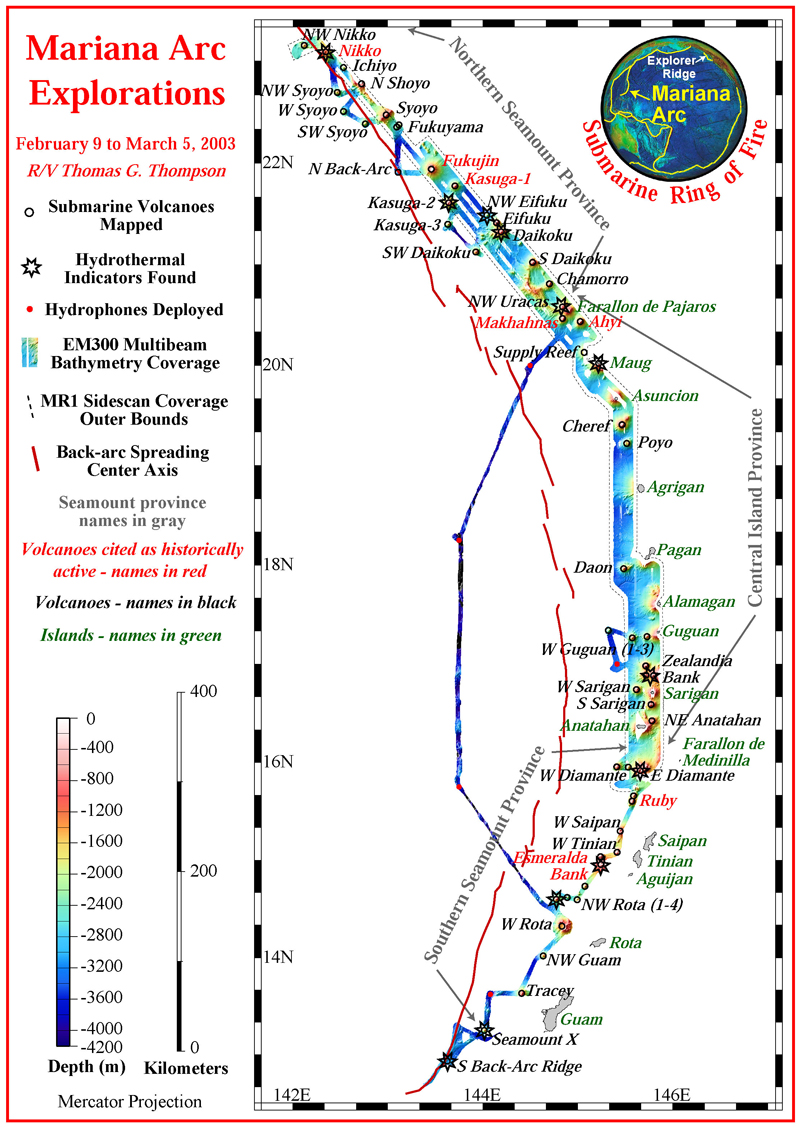 |
Figure 3. Bathymetry and other data gathered on the 2003 NOAA Ocean Explorer Program's 'Submarine Ring of Fire 2003' expedition at the Mariana Arc between 9 February and 5 March 2003. The stars indicate submarine volcanoes where evidence of hydrothermal activity was found. The volcanoes were mapped in high resolution, and sampled with a CTD, as indicated by the open black circles on the tracklines. The red dots represent the location of the deployed hydrophones and the red line represents the location of the back-arc spreading center. Daikoku is located in the Northern Seamount Province of the Mariana Arc. Courtesy of NOAA's 'Submarine Ring of Fire 2003' expedition. |
Geochemical sampling of the seawater is carried out with an instrument package that measures conductivity, temperature, and depth, commonly referred to as a CTD. Turbidity of the water, which estimates the concentration of particulate matter suspended in the plumes, is also measured. The CTD carries bottles for seawater sampling which is then geochemically analyzed.
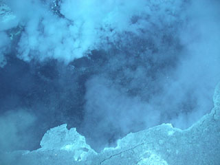
On 15 April 2004 the NOAA 'Submarine Ring of Fire 2004' expedition made a single dive at Daikoku and noted warm water present over large areas of sandy sediment deposits near the summit, and small flatfish in great abundance in the venting areas. The 'Submarine Ring of Fire 2006' expedition again visited Daikoku on 4 May 2006 and discovered a "cauldron" of molten sulfur (BGVN 31:05). They also observed extensive sulfur crusts in the vicinity of the cauldron, suggesting past emissions of liquid sulfur; they were able to sample a large piece of sulfur crust (figure 4). At that time, they also mapped two large craters on the summit. One pit was reported as over 100 m deep and about 80 m in diameter, and a large plume of white fluid was observed rising out of it.
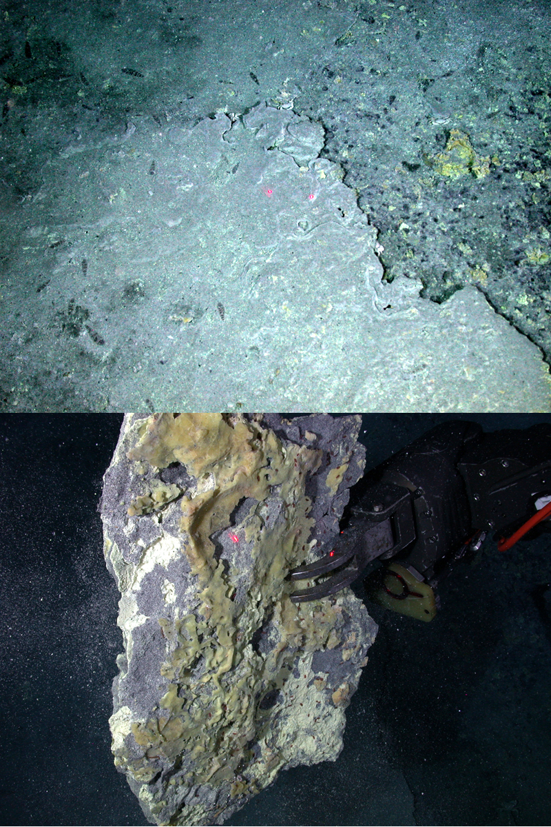 |
Figure 4. Sulfur crusts near the Diakoku "cauldron" were observed insitu as well as sampled by the ROV. Upper Image: Sulfur crusts in the vicinity of the sulfur cauldron (BGVN 31:05) imply past emissions of liquid sulfur at Daikoku. Lower Image: The Jason remotely operated vehicle (ROV) holds up a large piece of the sulfur crust that was sampled at Daikoku on 4 May 2006. The lasers- two red dots in the images- are 10 cm apart. Courtesy of Submarine Ring of Fire 2006 expedition, NOAA Ocean Explorer Program. |
Researchers from the NOAA Ocean Explorer program visited Daikoku again on 14 December 2014 during its 'Submarine Ring of Fire 2014 – Ironman' expedition, which was conducted from the R/V (Research Vessel) Revelle between 29 November and 22 December 2014. They gathered geochemical and bathymetric data which they were able to compare with 2003 data. The CTD information gathered in 2014 showed very strong plumes coming from the top of the seamount. The plumes had high turbidity, low pH, strong anomalies in reduced chemicals, and very high levels of hydrogen (figure 5).
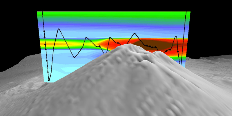 |
Figure 5. Cross-section over the top of Daikoku seamount measured on 14 December 2014 with the results from a CTD tow (black line), showing turbidity anomalies (warm colors indicate high particle concentrations) in the plume. Courtesy of 'Submarine Ring of Fire 2014 – Ironman' expedition, NOAA/PMEL, NSF. |
The 2014 bathymetry data revealed two summit craters; the larger one measured 150 m across and 100 m deep on the N side of the summit with a crater floor depth of 452 m below sea level, and the smaller one, about 50 m across on the NE flank, had a crater floor depth of 443 m below sea level. The bathymetry data from 2003 show only one small crater on the N side of the summit about 50 m across with a floor depth of 400 m below sea level (figure 6). The larger pit appeared to be about 70 m wider in 2014 than in 2006.
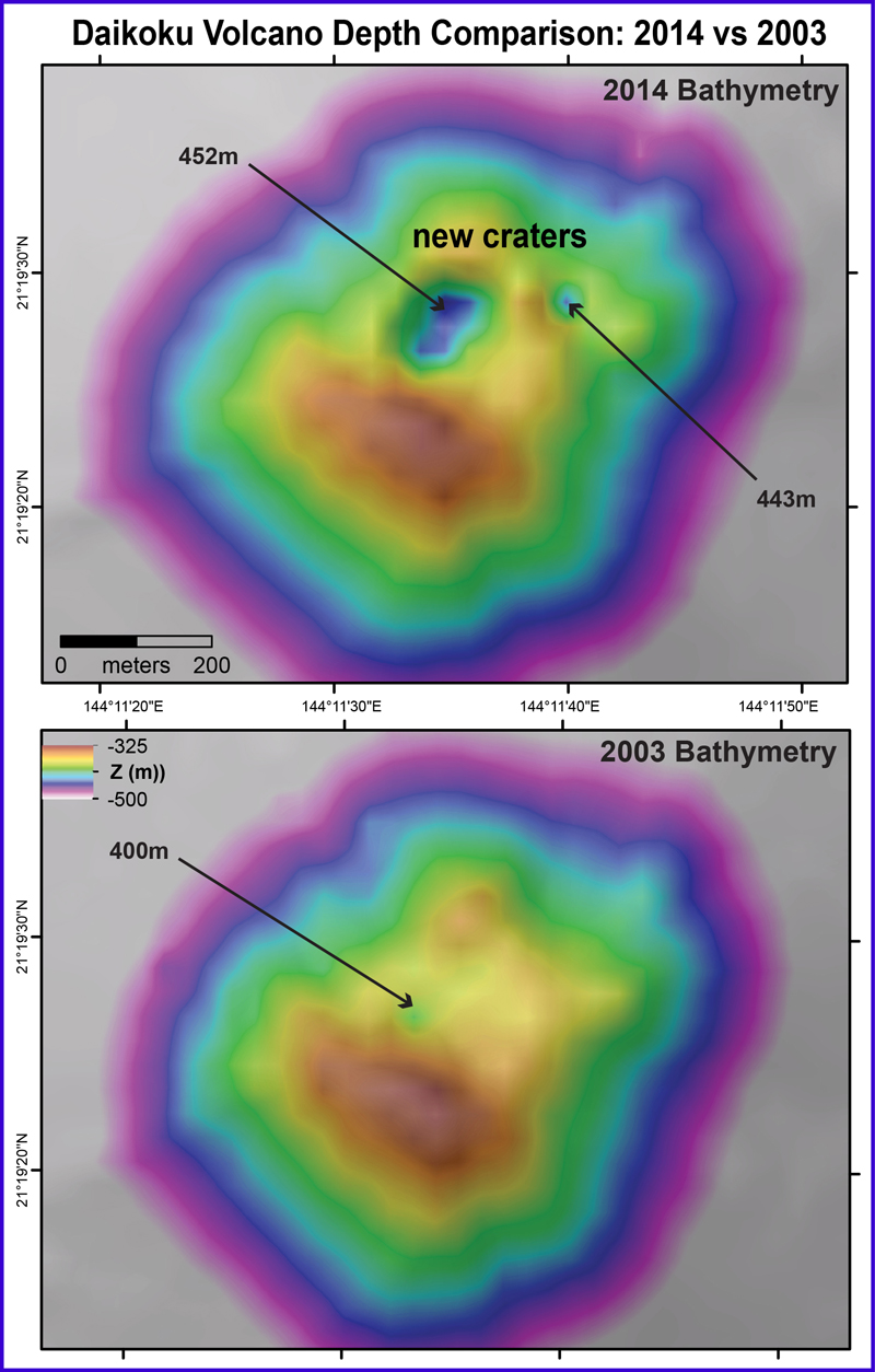 |
Figure 6. Bathymetric comparison of data collected at the Daikoku summit during the 2014 expedition (top) and in 2003 (bottom). The summit crater was significantly larger, and confirmed to be hydrothermally active by the CTD tow and midwater data collected by the 2014 expedition. A second crater has also appeared on the NE flank of the volcano. Arrows with numbers represent the depth below sea level (Z) in meters. Courtesy of 'Submarine Ring of Fire 2014 – Ironman' expedition, NSF/NOAA. |
On 3 and 4 December 2016, the Schmidt Ocean Institute Research Vessel R/V Falkor traveled to the Mariana back-arc with a multidisciplinary team of scientists to gather evidence of active hydrothermal vents and the life they support. They were able to make two ROV (Remotely Operated Vehicle) dives at Daikoku and collected data on the seamount and sea life living there. On their first dive they observed (and sampled) a fissure with a sulfur chimney caked with yellow sulfur, emitting white bubbles and particulates in 70°C water (figure 7).
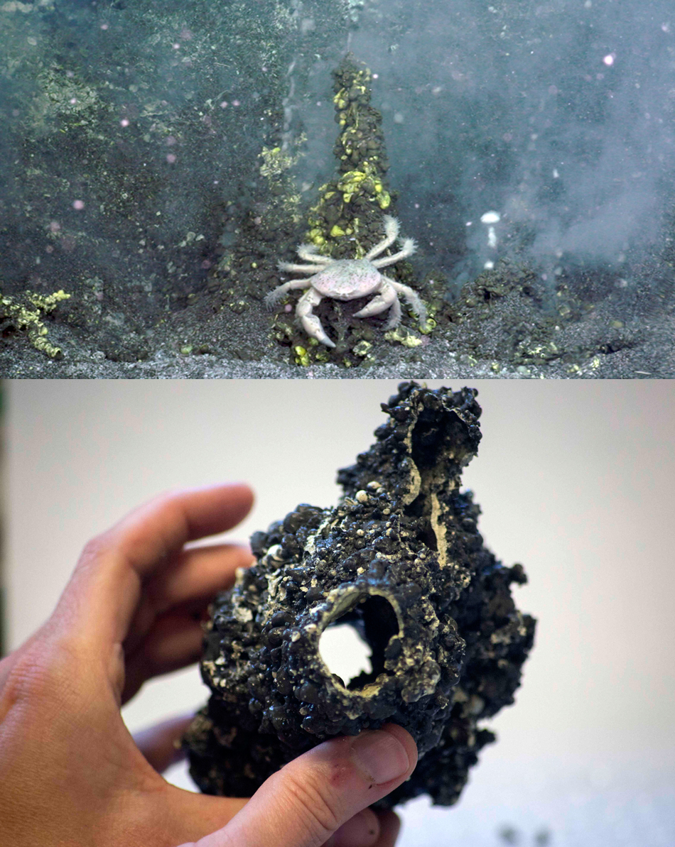 |
Figure 7. An active sulfur chimney at Daikoku on 3 December 2016 was videoed and sampled by the Schmidt Ocean Institute expedition. Upper Image: A fissure at Daikoku on 3 December 2016 with a yellow sulfur-caked chimney emitting white bubbles and particulates in 70°C water. Lower Image: The sulfur chimney was sampled by the ROV SuBastian for chemical analysis. Courtesy of Schmidt Ocean Institute, Expedition FK161129. |
On their second dive on 4 December 2016, they collected tube worms and crabs, and recorded the formation of "sulfur needles," tadpole-shaped fragments of sulfur that were previously observed in sampled sediments and seen floating in the water column. They appear to form when gas bubbles (probably CO2) rise through molten sulfur, forming a coating of sulfur around the bubble before the gas escapes (figure 8). Their video shows a sulfur chimney caked with yellow sulfur emitting yellow, white, and orange droplets of sulfur.
 |
Figure 8. Tadpole shaped "sulfur needles" coat the side of a sulfur chimney at Daikoku on 4 December 2016 as gas bubbles coated with sulfur rise through the chimney and drip residue around the sides. A video recording was also made of the chimney emitting bubbles (https://schmidtocean.org/cruise-log-post/daikoku-dive-2-sulfur-good/). Courtesy of Schmidt Ocean Institute, Expedition FK161129. |
The cruise scientists used the ship's EM302/710 multibeam echosounder to get a 2-m-resolution image of the summit crater, which they combined with water column data to create an image showing both the bathymetry of the volcano and the shape of the hydrothermal plume emitting from the summit (figure 9).
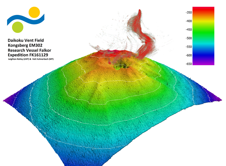 |
Figure 9. Multibeam echosounder data reveals the topography of the summit at Daikoku on 4 December 2016 as well as the shape of the hydrothermal plume emitting from the summit. Courtesy of Schmidt Ocean Institute, Expedition FK161129. |
Geological Summary. The conical summit of Daikoku seamount lies along an E-W ridge SE of Eifuku and rises to within 323 m of the sea surface. A steep-walled, 50-m-wide crater on the N flank, about 75 m below the summit, is at least 135 m deep and was observed to emit cloudy hydrothermal fluid. During a NOAA expedition in 2006, scientists observed a convecting black pool of liquid sulfur with a partly solidified, undulating sulfur crust at a depth of 420 m below the summit. Gases, particulates with the appearance of smoke, and liquid sulfur were bubbling up from an edge of the sulfur pool.
Information Contacts: Office of Ocean Exploration and Research, National Oceanic and Atmospheric Administration (NOAA), 1315 East-West Highway, Silver Spring, MD 20910, USA (URL: http://oceanexplorer.noaa.gov/, Cruise logs at: http://oceanexplorer.noaa.gov/explorations/03fire/logs/summary/summary.html, http://oceanexplorer.noaa.gov/explorations/04fire/logs/april15/april15.html, http://oceanexplorer.noaa.gov/explorations/06fire/logs/may4/may4.html, http://oceanexplorer.noaa.gov/explorations/14fire/logs/december14/december14.html); Schmidt Ocean Institute, 555 Bryant Street #374, Palo Alto, CA 94301, USA (URL: https://schmidtocean.org/, https://schmidtocean.org/cruise/searching-life-mariana-back-arc/).