
Explorations in 2014 and 2016 reveal active hydrothermal plumes and sulfur chimney formation
Daikoku seamount lies in the Northern Seamount Province of the Mariana Arc, and is about 850 km due N of Guam in the western Pacific Ocean. The summit is about 325 m below sea level and was first shown to be hydrothermally active in 2003 (figure 3). NOAA (National Oceanic and Atmospheric Administration) has conducted four expeditions to the Northern Mariana Islands in 2003, 2004, 2006, and 2014 under their Ocean Explorer program, specifically to study the volcanoes and the marine life they support. A comparison of the bathymetry recorded in 2003 and 2014 suggests that an explosion may have occurred at Daikoku during that interval, and both geochemical data and rock sampling indicate ongoing hydrothermal activity. In 2016, a research cruise conducted by the Schmidt Ocean Institute included a visit to Daikoku that revealed sulfur chimney formation.
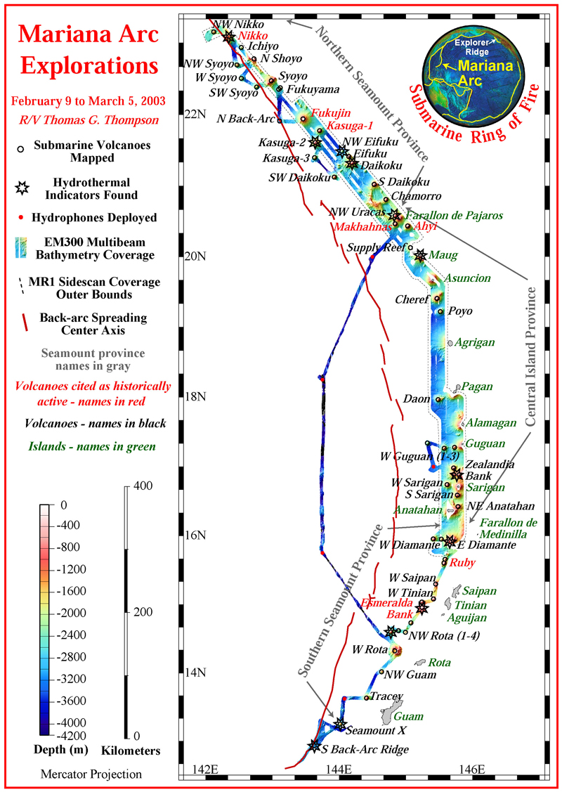 |
Figure 3. Bathymetry and other data gathered on the 2003 NOAA Ocean Explorer Program's 'Submarine Ring of Fire 2003' expedition at the Mariana Arc between 9 February and 5 March 2003. The stars indicate submarine volcanoes where evidence of hydrothermal activity was found. The volcanoes were mapped in high resolution, and sampled with a CTD, as indicated by the open black circles on the tracklines. The red dots represent the location of the deployed hydrophones and the red line represents the location of the back-arc spreading center. Daikoku is located in the Northern Seamount Province of the Mariana Arc. Courtesy of NOAA's 'Submarine Ring of Fire 2003' expedition. |
Geochemical sampling of the seawater is carried out with an instrument package that measures conductivity, temperature, and depth, commonly referred to as a CTD. Turbidity of the water, which estimates the concentration of particulate matter suspended in the plumes, is also measured. The CTD carries bottles for seawater sampling which is then geochemically analyzed.
On 15 April 2004 the NOAA 'Submarine Ring of Fire 2004' expedition made a single dive at Daikoku and noted warm water present over large areas of sandy sediment deposits near the summit, and small flatfish in great abundance in the venting areas. The 'Submarine Ring of Fire 2006' expedition again visited Daikoku on 4 May 2006 and discovered a "cauldron" of molten sulfur (BGVN 31:05). They also observed extensive sulfur crusts in the vicinity of the cauldron, suggesting past emissions of liquid sulfur; they were able to sample a large piece of sulfur crust (figure 4). At that time, they also mapped two large craters on the summit. One pit was reported as over 100 m deep and about 80 m in diameter, and a large plume of white fluid was observed rising out of it.
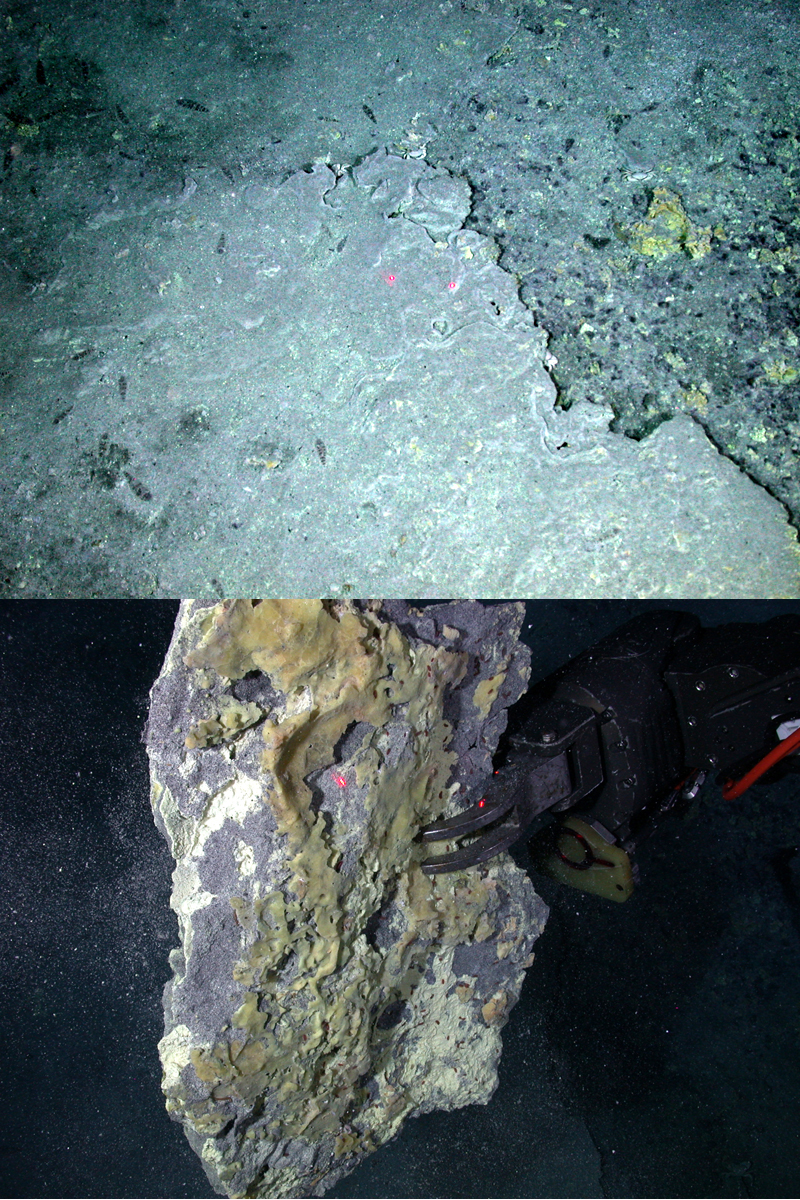 |
Figure 4. Sulfur crusts near the Diakoku "cauldron" were observed insitu as well as sampled by the ROV. Upper Image: Sulfur crusts in the vicinity of the sulfur cauldron (BGVN 31:05) imply past emissions of liquid sulfur at Daikoku. Lower Image: The Jason remotely operated vehicle (ROV) holds up a large piece of the sulfur crust that was sampled at Daikoku on 4 May 2006. The lasers- two red dots in the images- are 10 cm apart. Courtesy of Submarine Ring of Fire 2006 expedition, NOAA Ocean Explorer Program. |
Researchers from the NOAA Ocean Explorer program visited Daikoku again on 14 December 2014 during its 'Submarine Ring of Fire 2014 – Ironman' expedition, which was conducted from the R/V (Research Vessel) Revelle between 29 November and 22 December 2014. They gathered geochemical and bathymetric data which they were able to compare with 2003 data. The CTD information gathered in 2014 showed very strong plumes coming from the top of the seamount. The plumes had high turbidity, low pH, strong anomalies in reduced chemicals, and very high levels of hydrogen (figure 5).
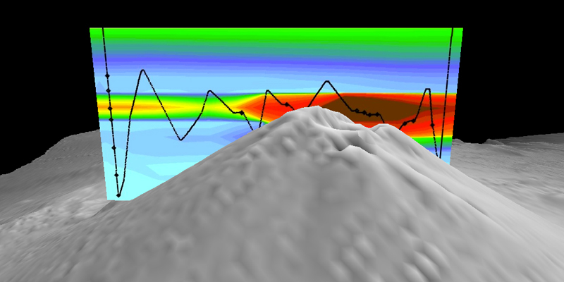 |
Figure 5. Cross-section over the top of Daikoku seamount measured on 14 December 2014 with the results from a CTD tow (black line), showing turbidity anomalies (warm colors indicate high particle concentrations) in the plume. Courtesy of 'Submarine Ring of Fire 2014 – Ironman' expedition, NOAA/PMEL, NSF. |
The 2014 bathymetry data revealed two summit craters; the larger one measured 150 m across and 100 m deep on the N side of the summit with a crater floor depth of 452 m below sea level, and the smaller one, about 50 m across on the NE flank, had a crater floor depth of 443 m below sea level. The bathymetry data from 2003 show only one small crater on the N side of the summit about 50 m across with a floor depth of 400 m below sea level (figure 6). The larger pit appeared to be about 70 m wider in 2014 than in 2006.
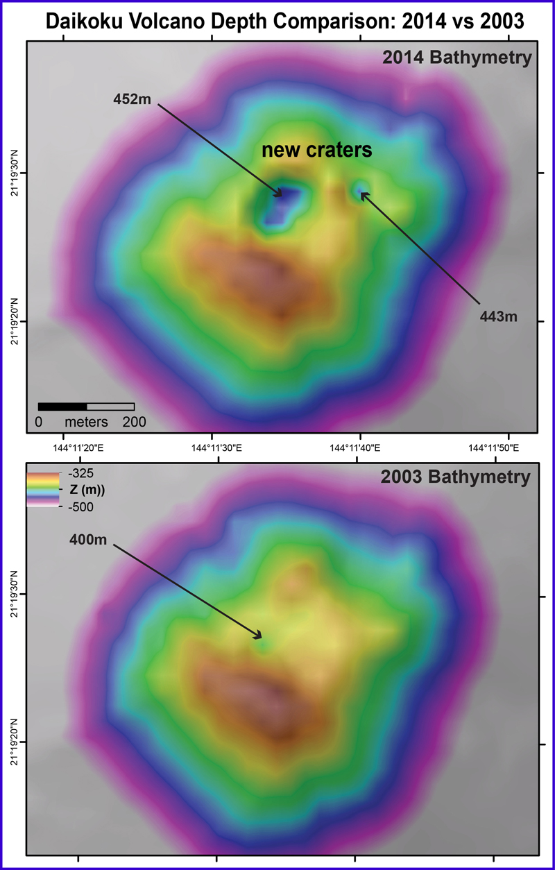 |
Figure 6. Bathymetric comparison of data collected at the Daikoku summit during the 2014 expedition (top) and in 2003 (bottom). The summit crater was significantly larger, and confirmed to be hydrothermally active by the CTD tow and midwater data collected by the 2014 expedition. A second crater has also appeared on the NE flank of the volcano. Arrows with numbers represent the depth below sea level (Z) in meters. Courtesy of 'Submarine Ring of Fire 2014 – Ironman' expedition, NSF/NOAA. |
On 3 and 4 December 2016, the Schmidt Ocean Institute Research Vessel R/V Falkor traveled to the Mariana back-arc with a multidisciplinary team of scientists to gather evidence of active hydrothermal vents and the life they support. They were able to make two ROV (Remotely Operated Vehicle) dives at Daikoku and collected data on the seamount and sea life living there. On their first dive they observed (and sampled) a fissure with a sulfur chimney caked with yellow sulfur, emitting white bubbles and particulates in 70°C water (figure 7).
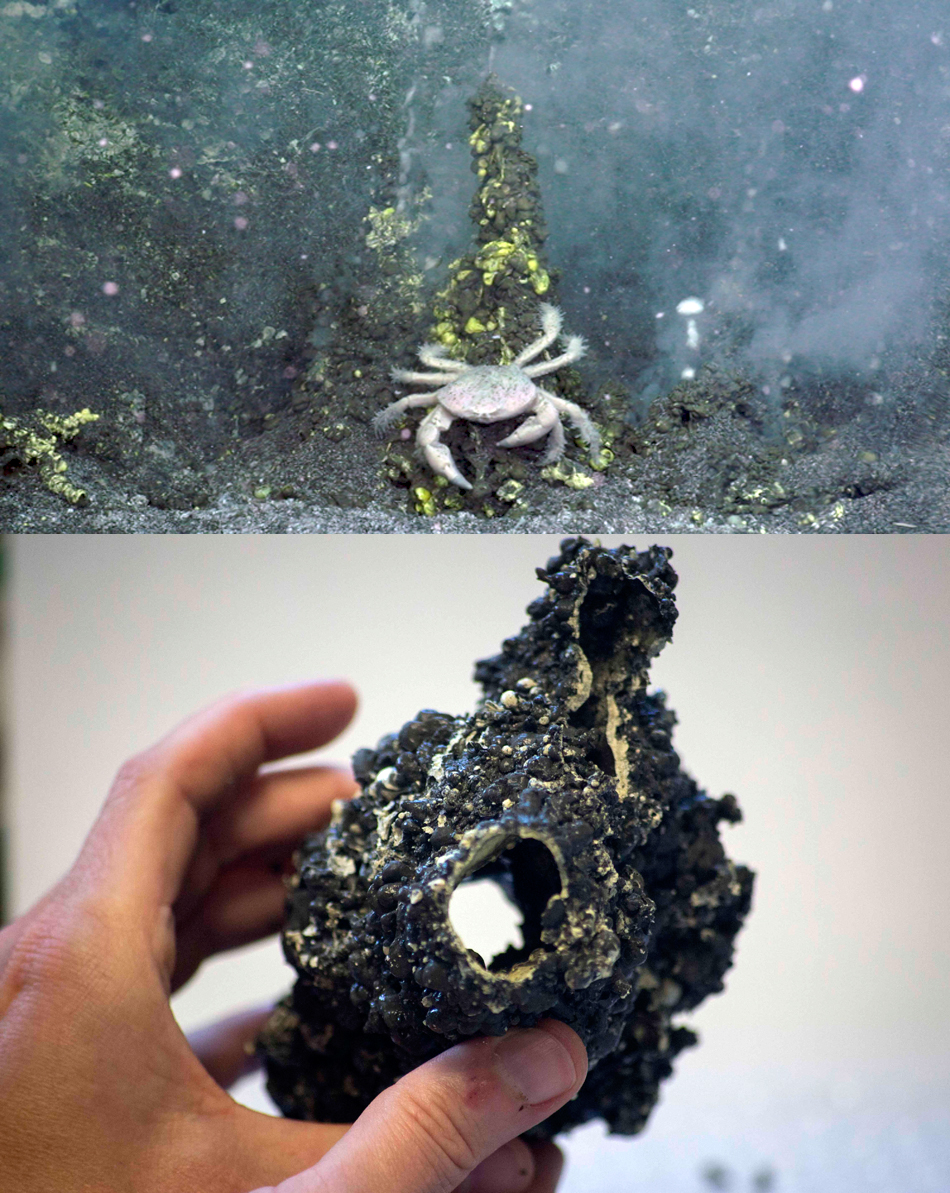 |
Figure 7. An active sulfur chimney at Daikoku on 3 December 2016 was videoed and sampled by the Schmidt Ocean Institute expedition. Upper Image: A fissure at Daikoku on 3 December 2016 with a yellow sulfur-caked chimney emitting white bubbles and particulates in 70°C water. Lower Image: The sulfur chimney was sampled by the ROV SuBastian for chemical analysis. Courtesy of Schmidt Ocean Institute, Expedition FK161129. |
On their second dive on 4 December 2016, they collected tube worms and crabs, and recorded the formation of "sulfur needles," tadpole-shaped fragments of sulfur that were previously observed in sampled sediments and seen floating in the water column. They appear to form when gas bubbles (probably CO2) rise through molten sulfur, forming a coating of sulfur around the bubble before the gas escapes (figure 8). Their video shows a sulfur chimney caked with yellow sulfur emitting yellow, white, and orange droplets of sulfur.
 |
Figure 8. Tadpole shaped "sulfur needles" coat the side of a sulfur chimney at Daikoku on 4 December 2016 as gas bubbles coated with sulfur rise through the chimney and drip residue around the sides. A video recording was also made of the chimney emitting bubbles (https://schmidtocean.org/cruise-log-post/daikoku-dive-2-sulfur-good/). Courtesy of Schmidt Ocean Institute, Expedition FK161129. |
The cruise scientists used the ship's EM302/710 multibeam echosounder to get a 2-m-resolution image of the summit crater, which they combined with water column data to create an image showing both the bathymetry of the volcano and the shape of the hydrothermal plume emitting from the summit (figure 9).
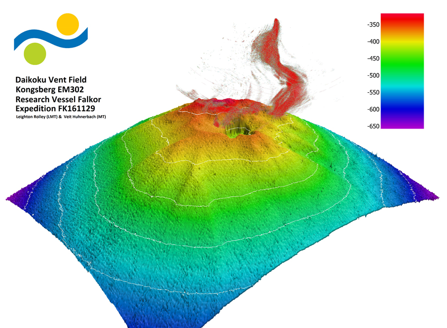 |
Figure 9. Multibeam echosounder data reveals the topography of the summit at Daikoku on 4 December 2016 as well as the shape of the hydrothermal plume emitting from the summit. Courtesy of Schmidt Ocean Institute, Expedition FK161129. |
Information Contacts: Office of Ocean Exploration and Research, National Oceanic and Atmospheric Administration (NOAA), 1315 East-West Highway, Silver Spring, MD 20910, USA (URL: http://oceanexplorer.noaa.gov/, Cruise logs at: http://oceanexplorer.noaa.gov/explorations/03fire/logs/summary/summary.html, http://oceanexplorer.noaa.gov/explorations/04fire/logs/april15/april15.html, http://oceanexplorer.noaa.gov/explorations/06fire/logs/may4/may4.html, http://oceanexplorer.noaa.gov/explorations/14fire/logs/december14/december14.html); Schmidt Ocean Institute, 555 Bryant Street #374, Palo Alto, CA 94301, USA (URL: https://schmidtocean.org/, https://schmidtocean.org/cruise/searching-life-mariana-back-arc/).
The Global Volcanism Program has no Weekly Reports available for Daikoku.
Reports are organized chronologically and indexed below by Month/Year (Publication Volume:Number), and include a one-line summary. Click on the index link or scroll down to read the reports.
Discovery of agitated pool of molten sulfur at 420 m ocean depth
Submarine exploration at Daikoku seamount has discovered a small pit or cauldron containing a pool of molten sulfur. During the period of 18 April-13 May 2006, scientists from the National Oceanic and Atmospheric Agency (NOAA), aboard the research vessel Melville completed the 2006 Submarine Ring of Fire Expedition. This expedition was the third in a series exploring of the submarine volcanoes lying along the Mariana arc (figure 1). The arc extends from S of the island of Guam northward more than 1,450 km. Daily logs of the 2006 expedition, including photographs and video clips, can be viewed on the NOAA Ocean Explorer website (see Information Contacts below).
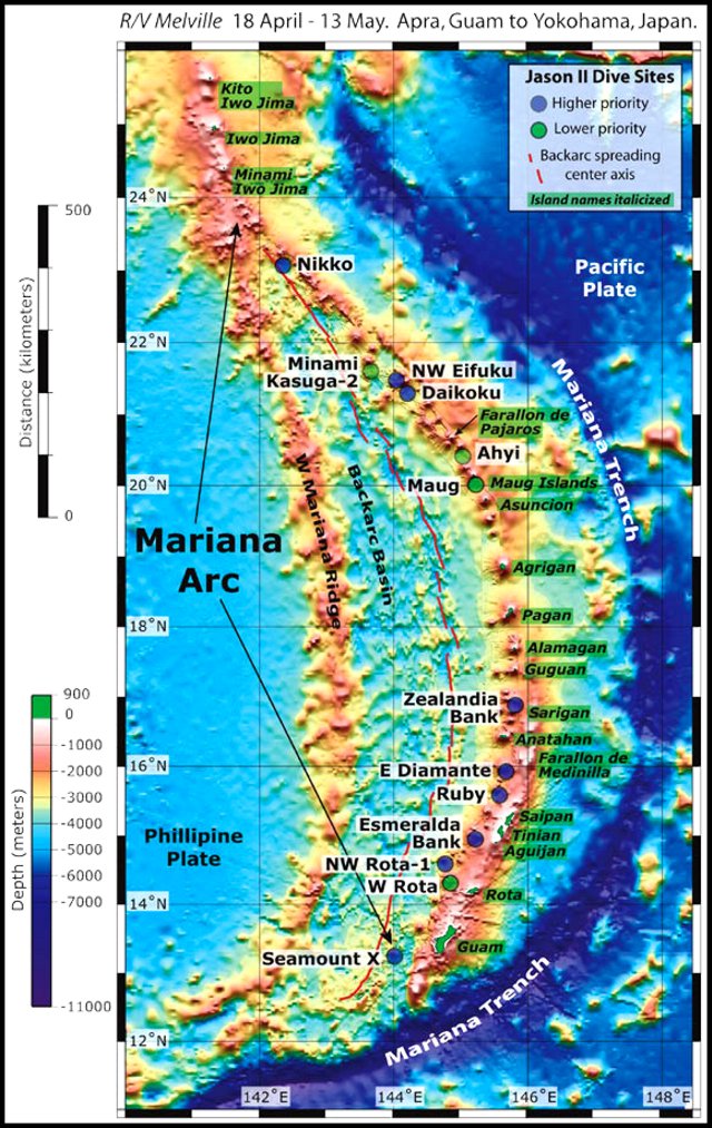 |
Figure 1. Bathymetric tectonic map of the Marianas arc showing islands and seamounts (with respective labels on backgrounds of dark and white). Reports in this issue discuss (from N to S), Diakoku, Anatahan, and NW Rotoa-1. Courtesy of Submarine Ring of Fire 2006 Expedition, NOAA Vents Program. |
William Chadwick reported on the 2006 expedition (Oregon State University press release, 25 May 2006) that ". . . on another volcano called Daikoku, in the northern part of the Mariana volcanic arc, the researchers discovered a pool of molten sulfur at a depth of 420 m. It was measured at 187°C. It was a sulfur pond with a flexible 'crust' that was moving in a wavelike motion. The movement was triggered by continuous gases being emitted from beneath the pool and passing through the sulfur." (figure 2).
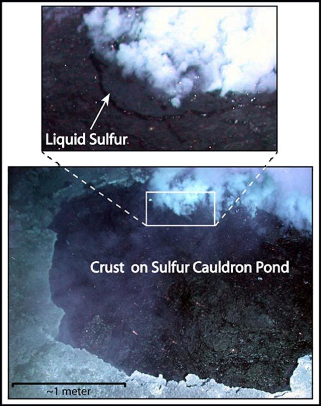 |
Figure 2. On 4 May 2006 scientists piloting the submersible Remotely Operated Vehicle (ROV) Jason at Daikoku observed and photographed a convecting, black pool of liquid sulfur (inset, and upper image) with a partly solidified sulfur crust (bottom image). Gases, particulate with the appearance of smoke, and liquid sulfur were bubbling up from the back edge of the sulfur pool. The top image shows a zoomed-in view of the liquid sulfur extruding from a fracture in the solid crust. Image courtesy of Submarine Ring of Fire 2006 Expedition, NOAA Vents Program. |
In another pit on the summit of Daikoku, over 100 m deep and ~ 80 m in diameter, the scientists observed a large plume of slowly rising white fluid.
References. Embley, R.W., Baker, E.T., Chadwick, W.W., Jr., Lipton, J.E., Resing, J.A., Massoth, G.J., and Nakamura, K., 2004, Explorations of Mariana Arc volcanoes reveal new hydrothermal systems: EOS, Transactions, American Geophysical Union, v. 85, no. 2, p. 37, 40.
Embley, R.W., Chadwick, W.W., Jr, Baker, E.T., Butterfield, D.A., Resing, J.A., de Ronde, C. E.J., Tunnicliffe, V., Lupton, J.E., Juniper, S.K., Rubin, K.H., Stern, R.J., Lebon, G.T., Nakamura, K., Merle, S.G., Hein, J.R., Wiens, D.A., and Tamura, Y., 2006, Long-term eruptive activity at a submarine arc volcano: Nature, v. 441, no. 7092, p. 494-497.
Oregon State University, 25 May 2006, Press Release: Nature paper details eruption activity at submarine volcano: College of Oceanic and Atmospheric Science (COAS), 104 COAS Admininstration Building, Corvallis, OR 97331.
Information Contacts: William W. Chadwick, Jr., Cooperative Institute for Marine Resources Studies (CIMRS), NOAA Pacific Marine Environmental Laboratory (PMEL), 2115 SE OSU Drive, Newport, OR 97365 USA; NOAA Ocean Explorer (URL: http://oceanexplorer.noaa.gov/explorations/06fire/welcome.html).
Explorations in 2014 and 2016 reveal active hydrothermal plumes and sulfur chimney formation
Daikoku seamount lies in the Northern Seamount Province of the Mariana Arc, and is about 850 km due N of Guam in the western Pacific Ocean. The summit is about 325 m below sea level and was first shown to be hydrothermally active in 2003 (figure 3). NOAA (National Oceanic and Atmospheric Administration) has conducted four expeditions to the Northern Mariana Islands in 2003, 2004, 2006, and 2014 under their Ocean Explorer program, specifically to study the volcanoes and the marine life they support. A comparison of the bathymetry recorded in 2003 and 2014 suggests that an explosion may have occurred at Daikoku during that interval, and both geochemical data and rock sampling indicate ongoing hydrothermal activity. In 2016, a research cruise conducted by the Schmidt Ocean Institute included a visit to Daikoku that revealed sulfur chimney formation.
|
Figure 3. Bathymetry and other data gathered on the 2003 NOAA Ocean Explorer Program's 'Submarine Ring of Fire 2003' expedition at the Mariana Arc between 9 February and 5 March 2003. The stars indicate submarine volcanoes where evidence of hydrothermal activity was found. The volcanoes were mapped in high resolution, and sampled with a CTD, as indicated by the open black circles on the tracklines. The red dots represent the location of the deployed hydrophones and the red line represents the location of the back-arc spreading center. Daikoku is located in the Northern Seamount Province of the Mariana Arc. Courtesy of NOAA's 'Submarine Ring of Fire 2003' expedition. |
Geochemical sampling of the seawater is carried out with an instrument package that measures conductivity, temperature, and depth, commonly referred to as a CTD. Turbidity of the water, which estimates the concentration of particulate matter suspended in the plumes, is also measured. The CTD carries bottles for seawater sampling which is then geochemically analyzed.
On 15 April 2004 the NOAA 'Submarine Ring of Fire 2004' expedition made a single dive at Daikoku and noted warm water present over large areas of sandy sediment deposits near the summit, and small flatfish in great abundance in the venting areas. The 'Submarine Ring of Fire 2006' expedition again visited Daikoku on 4 May 2006 and discovered a "cauldron" of molten sulfur (BGVN 31:05). They also observed extensive sulfur crusts in the vicinity of the cauldron, suggesting past emissions of liquid sulfur; they were able to sample a large piece of sulfur crust (figure 4). At that time, they also mapped two large craters on the summit. One pit was reported as over 100 m deep and about 80 m in diameter, and a large plume of white fluid was observed rising out of it.
|
Figure 4. Sulfur crusts near the Diakoku "cauldron" were observed insitu as well as sampled by the ROV. Upper Image: Sulfur crusts in the vicinity of the sulfur cauldron (BGVN 31:05) imply past emissions of liquid sulfur at Daikoku. Lower Image: The Jason remotely operated vehicle (ROV) holds up a large piece of the sulfur crust that was sampled at Daikoku on 4 May 2006. The lasers- two red dots in the images- are 10 cm apart. Courtesy of Submarine Ring of Fire 2006 expedition, NOAA Ocean Explorer Program. |
Researchers from the NOAA Ocean Explorer program visited Daikoku again on 14 December 2014 during its 'Submarine Ring of Fire 2014 – Ironman' expedition, which was conducted from the R/V (Research Vessel) Revelle between 29 November and 22 December 2014. They gathered geochemical and bathymetric data which they were able to compare with 2003 data. The CTD information gathered in 2014 showed very strong plumes coming from the top of the seamount. The plumes had high turbidity, low pH, strong anomalies in reduced chemicals, and very high levels of hydrogen (figure 5).
|
Figure 5. Cross-section over the top of Daikoku seamount measured on 14 December 2014 with the results from a CTD tow (black line), showing turbidity anomalies (warm colors indicate high particle concentrations) in the plume. Courtesy of 'Submarine Ring of Fire 2014 – Ironman' expedition, NOAA/PMEL, NSF. |
The 2014 bathymetry data revealed two summit craters; the larger one measured 150 m across and 100 m deep on the N side of the summit with a crater floor depth of 452 m below sea level, and the smaller one, about 50 m across on the NE flank, had a crater floor depth of 443 m below sea level. The bathymetry data from 2003 show only one small crater on the N side of the summit about 50 m across with a floor depth of 400 m below sea level (figure 6). The larger pit appeared to be about 70 m wider in 2014 than in 2006.
|
Figure 6. Bathymetric comparison of data collected at the Daikoku summit during the 2014 expedition (top) and in 2003 (bottom). The summit crater was significantly larger, and confirmed to be hydrothermally active by the CTD tow and midwater data collected by the 2014 expedition. A second crater has also appeared on the NE flank of the volcano. Arrows with numbers represent the depth below sea level (Z) in meters. Courtesy of 'Submarine Ring of Fire 2014 – Ironman' expedition, NSF/NOAA. |
On 3 and 4 December 2016, the Schmidt Ocean Institute Research Vessel R/V Falkor traveled to the Mariana back-arc with a multidisciplinary team of scientists to gather evidence of active hydrothermal vents and the life they support. They were able to make two ROV (Remotely Operated Vehicle) dives at Daikoku and collected data on the seamount and sea life living there. On their first dive they observed (and sampled) a fissure with a sulfur chimney caked with yellow sulfur, emitting white bubbles and particulates in 70°C water (figure 7).
|
Figure 7. An active sulfur chimney at Daikoku on 3 December 2016 was videoed and sampled by the Schmidt Ocean Institute expedition. Upper Image: A fissure at Daikoku on 3 December 2016 with a yellow sulfur-caked chimney emitting white bubbles and particulates in 70°C water. Lower Image: The sulfur chimney was sampled by the ROV SuBastian for chemical analysis. Courtesy of Schmidt Ocean Institute, Expedition FK161129. |
On their second dive on 4 December 2016, they collected tube worms and crabs, and recorded the formation of "sulfur needles," tadpole-shaped fragments of sulfur that were previously observed in sampled sediments and seen floating in the water column. They appear to form when gas bubbles (probably CO2) rise through molten sulfur, forming a coating of sulfur around the bubble before the gas escapes (figure 8). Their video shows a sulfur chimney caked with yellow sulfur emitting yellow, white, and orange droplets of sulfur.
|
Figure 8. Tadpole shaped "sulfur needles" coat the side of a sulfur chimney at Daikoku on 4 December 2016 as gas bubbles coated with sulfur rise through the chimney and drip residue around the sides. A video recording was also made of the chimney emitting bubbles (https://schmidtocean.org/cruise-log-post/daikoku-dive-2-sulfur-good/). Courtesy of Schmidt Ocean Institute, Expedition FK161129. |
The cruise scientists used the ship's EM302/710 multibeam echosounder to get a 2-m-resolution image of the summit crater, which they combined with water column data to create an image showing both the bathymetry of the volcano and the shape of the hydrothermal plume emitting from the summit (figure 9).
|
Figure 9. Multibeam echosounder data reveals the topography of the summit at Daikoku on 4 December 2016 as well as the shape of the hydrothermal plume emitting from the summit. Courtesy of Schmidt Ocean Institute, Expedition FK161129. |
Information Contacts: Office of Ocean Exploration and Research, National Oceanic and Atmospheric Administration (NOAA), 1315 East-West Highway, Silver Spring, MD 20910, USA (URL: http://oceanexplorer.noaa.gov/, Cruise logs at: http://oceanexplorer.noaa.gov/explorations/03fire/logs/summary/summary.html, http://oceanexplorer.noaa.gov/explorations/04fire/logs/april15/april15.html, http://oceanexplorer.noaa.gov/explorations/06fire/logs/may4/may4.html, http://oceanexplorer.noaa.gov/explorations/14fire/logs/december14/december14.html); Schmidt Ocean Institute, 555 Bryant Street #374, Palo Alto, CA 94301, USA (URL: https://schmidtocean.org/, https://schmidtocean.org/cruise/searching-life-mariana-back-arc/).
The Global Volcanism Program has no synonyms or subfeatures listed for Daikoku.
|
|
||||||||||||||||||||||||||
The Global Volcanism Program is not aware of any Holocene eruptions from Daikoku. If this volcano has had large eruptions (VEI >= 4) prior to 10,000 years ago, information might be found on the Daikoku page in the LaMEVE (Large Magnitude Explosive Volcanic Eruptions) database, a part of the Volcano Global Risk Identification and Analysis Project (VOGRIPA).
There is no Deformation History data available for Daikoku.
There is no Emissions History data available for Daikoku.
Maps are not currently available due to technical issues.
The maps shown below have been scanned from the GVP map archives and include the volcano on this page. Clicking on the small images will load the full 300 dpi map. Very small-scale maps (such as world maps) are not included.
There are no samples for Daikoku in the Smithsonian's NMNH Department of Mineral Sciences Rock and Ore collection.
| Copernicus Browser | The Copernicus Browser replaced the Sentinel Hub Playground browser in 2023, to provide access to Earth observation archives from the Copernicus Data Space Ecosystem, the main distribution platform for data from the EU Copernicus missions. |
| MIROVA | Middle InfraRed Observation of Volcanic Activity (MIROVA) is a near real time volcanic hot-spot detection system based on the analysis of MODIS (Moderate Resolution Imaging Spectroradiometer) data. In particular, MIROVA uses the Middle InfraRed Radiation (MIR), measured over target volcanoes, in order to detect, locate and measure the heat radiation sourced from volcanic activity. |
| MODVOLC Thermal Alerts | Using infrared satellite Moderate Resolution Imaging Spectroradiometer (MODIS) data, scientists at the Hawai'i Institute of Geophysics and Planetology, University of Hawai'i, developed an automated system called MODVOLC to map thermal hot-spots in near real time. For each MODIS image, the algorithm automatically scans each 1 km pixel within it to check for high-temperature hot-spots. When one is found the date, time, location, and intensity are recorded. MODIS looks at every square km of the Earth every 48 hours, once during the day and once during the night, and the presence of two MODIS sensors in space allows at least four hot-spot observations every two days. Each day updated global maps are compiled to display the locations of all hot spots detected in the previous 24 hours. There is a drop-down list with volcano names which allow users to 'zoom-in' and examine the distribution of hot-spots at a variety of spatial scales. |
|
WOVOdat
Single Volcano View Temporal Evolution of Unrest Side by Side Volcanoes |
WOVOdat is a database of volcanic unrest; instrumentally and visually recorded changes in seismicity, ground deformation, gas emission, and other parameters from their normal baselines. It is sponsored by the World Organization of Volcano Observatories (WOVO) and presently hosted at the Earth Observatory of Singapore.
GVMID Data on Volcano Monitoring Infrastructure The Global Volcano Monitoring Infrastructure Database GVMID, is aimed at documenting and improving capabilities of volcano monitoring from the ground and space. GVMID should provide a snapshot and baseline view of the techniques and instrumentation that are in place at various volcanoes, which can be use by volcano observatories as reference to setup new monitoring system or improving networks at a specific volcano. These data will allow identification of what monitoring gaps exist, which can be then targeted by remote sensing infrastructure and future instrument deployments. |
| Volcanic Hazard Maps | The IAVCEI Commission on Volcanic Hazards and Risk has a Volcanic Hazard Maps database designed to serve as a resource for hazard mappers (or other interested parties) to explore how common issues in hazard map development have been addressed at different volcanoes, in different countries, for different hazards, and for different intended audiences. In addition to the comprehensive, searchable Volcanic Hazard Maps Database, this website contains information about diversity of volcanic hazard maps, illustrated using examples from the database. This site is for educational purposes related to volcanic hazard maps. Hazard maps found on this website should not be used for emergency purposes. For the most recent, official hazard map for a particular volcano, please seek out the proper institutional authorities on the matter. |
| IRIS seismic stations/networks | Incorporated Research Institutions for Seismology (IRIS) Data Services map showing the location of seismic stations from all available networks (permanent or temporary) within a radius of 0.18° (about 20 km at mid-latitudes) from the given location of Daikoku. Users can customize a variety of filters and options in the left panel. Note that if there are no stations are known the map will default to show the entire world with a "No data matched request" error notice. |
| UNAVCO GPS/GNSS stations | Geodetic Data Services map from UNAVCO showing the location of GPS/GNSS stations from all available networks (permanent or temporary) within a radius of 20 km from the given location of Daikoku. Users can customize the data search based on station or network names, location, and time window. Requires Adobe Flash Player. |
| DECADE Data | The DECADE portal, still in the developmental stage, serves as an example of the proposed interoperability between The Smithsonian Institution's Global Volcanism Program, the Mapping Gas Emissions (MaGa) Database, and the EarthChem Geochemical Portal. The Deep Earth Carbon Degassing (DECADE) initiative seeks to use new and established technologies to determine accurate global fluxes of volcanic CO2 to the atmosphere, but installing CO2 monitoring networks on 20 of the world's 150 most actively degassing volcanoes. The group uses related laboratory-based studies (direct gas sampling and analysis, melt inclusions) to provide new data for direct degassing of deep earth carbon to the atmosphere. |
| Large Eruptions of Daikoku | Information about large Quaternary eruptions (VEI >= 4) is cataloged in the Large Magnitude Explosive Volcanic Eruptions (LaMEVE) database of the Volcano Global Risk Identification and Analysis Project (VOGRIPA). |
| EarthChem | EarthChem develops and maintains databases, software, and services that support the preservation, discovery, access and analysis of geochemical data, and facilitate their integration with the broad array of other available earth science parameters. EarthChem is operated by a joint team of disciplinary scientists, data scientists, data managers and information technology developers who are part of the NSF-funded data facility Integrated Earth Data Applications (IEDA). IEDA is a collaborative effort of EarthChem and the Marine Geoscience Data System (MGDS). |


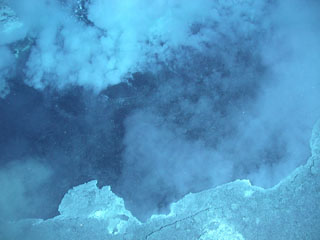 A plume rises from a vent at about 400 m depth on Daikoku seamount in this close-up view only about a few meters across. During a NOAA expedition in 2006 scientists observed a convecting, black pool of liquid sulfur with a partly solidified, undulating sulfur crust. The summit of lies along an E-W-trending ridge SE of Eifuku submarine volcano and rises to within about 300 m of the ocean surface.