Report on Fuego (Guatemala) — May 2017

Bulletin of the Global Volcanism Network, vol. 42, no. 5 (May 2017)
Managing Editor: Edward Venzke.
Edited by A. Elizabeth Crafford.
Fuego (Guatemala) Strombolian activity, lava and pyroclastic flows, lahars, and ash plumes, June 2014-December 2015
Please cite this report as:
Global Volcanism Program, 2017. Report on Fuego (Guatemala) (Crafford, A.E., and Venzke, E., eds.). Bulletin of the Global Volcanism Network, 42:5. Smithsonian Institution. https://doi.org/10.5479/si.GVP.BGVN201705-342090
Fuego
Guatemala
14.4748°N, 90.8806°W; summit elev. 3799 m
All times are local (unless otherwise noted)
Volcán de Fuego, one of three active volcanos in Guatemala, has been erupting continuously since 2002. Historical observations of eruptions date back to 1531, and radiocarbon dates are confirmed back to 1580 BCE. These eruptions have resulted in major ashfalls, pyroclastic flows, lava flows, and damaging lahars. A major explosion on 13 September 2012 that caused significant ashfall to the S and SW (figure 30) was described by the Instituto Nacional de Sismologia, Vulcanología, Meteorología e Hidrologia (INSIVUMEH) as the largest event in the prior 13 years. From September 2012 through June 2014 continuing explosions with ash plumes and ashfall, pyroclastic flows, lahars, and lava flows have impacted much of the region within 20 km of the volcano (BGVN 39:04). This report covers the ongoing activity from June 2014 through mid-December 2015. In addition to regular reports from INSIVUMEH, information comes from the Coordinadora Nacional para la Reducción de Desastres (CONRED), and aviation alerts are provided by the Washington Volcanic Ash Advisory Center (VAAC).
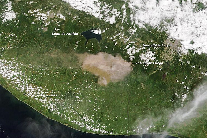 |
Figure 30. Guatemala's Volcán de Fuego (Volcano of Fire) erupted on the morning of 13 September 2012. According to the Coordinadora Nacional para la Reducción de Desastres (CONRED), the eruption included ash emissions to the W and a 500-m-long lava flow. This natural-color image was acquired by the Moderate Resolution Imaging Spectroradiometer (MODIS) aboard the Terra satellite. Courtesy of NASA-Earth Observatory. |
Fuego was continuously active from June 2014 through December 2015. Ash plumes generally rose to heights of less than 1 km above the summit (4.8 km altitude) and dispersed ash over villages located 10-15 km S, SW, and W virtually every week, and occasionally to the NE and E. The highest plumes rose to 5.75 km in October 2014, 5.8 km in January 2015, and at least 6.1 km in February 2015. The most significant ash eruptions were in February 2015 when air traffic was disrupted in Guatemala City and in November 2015 when ashfall was reported up to 90 km SW. Incandescent ejecta rose 100-300 m above the crater rim on a regular basis, but the strongest events sent tephra and lava fountains as high as 500 m in July 2014, 800 m in August 2014, and 500 m in December 2015. Pyroclastic flows descended several drainages during larger explosive events in February, July, September, and November 2015. Numerous lava flows affected at least five different drainages around Fuego. They were reported during June, July, and August 2014, and February-April, June, and September-November 2015. Lahars during June and September 2014 and June 2015 damaged roadways and filled ravines with meter-sized debris. Table 12 shows the towns and drainages mentioned in the report and their distances and directions from the summit of Fuego, and is posted at the end of this report.
Activity during June-December 2014. Activity at Fuego during June 2014 was dominated by explosions that produced ash plumes which rose between 100 and 800 m above the summit (3.9-4.6 km altitude), and drifted most often generally westward. Minor amounts of ash were reported from explosions on 18-19 June in towns within 15 km of the summit, mainly El Porvenir (8 km ENE), Los Yucales (12 km SW), Santa Sofía (12 km SW), Morelia (10 km SW), Sangre de Cristo (10 km SW), and Panimaché (I and II, ~8 km SW). The Washington VAAC issued three reports of minor volcanic ash from explosions on 18, 20, and 23 June, which dissipated within a few hours.
Numerous lahars impacted drainages in June. Las Lajas (SE), Honda (E), and Seca (W) drainages were affected on 1 June, and Las Lajas and El Jute (SE) were impacted the next day. Honda, El Jute, Ceniza (SSW), and Santa Teresa (S) drainages had 1.5-m-diameter blocks in lahars on 5 June, and there were more lahars in Las Lajas and El Jute drainages on 9 June. Incandescent ejecta rose 100-200 m above the crater rim several times, and was responsible for avalanches descending the Taniluyá (SW), Trinidad (S), and Ceniza drainages. A new lava flow reported on 29 June descended the Taniluyá drainage for 150 m and caused avalanches in the nearby Ceniza drainage.
Surges of lava and incandescent avalanches traveled down six drainages (Santa Teresa, Taniluya, Ceniza, Trinidad, Las Lajas, and Honda) during the first half of July 2014, the farthest going 400 m down the Ceniza. MODVOLC thermal alerts possibly related to the lava flows and incandescent material were captured on 1, 2, and 11 July. Pulses of incandescent material rose to 100 m above the rim in early July, but increased to heights up to 500 m above the crater for the second half of the month, causing block avalanches down the flanks. Weak-to-moderate ash-bearing explosions early in the month increased to moderate-to-strong explosions by month's end that sent dark gray ash 400-600 m above the crater. The Washington VAAC reported ash plumes on 8, 11, 18, and 31 July. While no emissions were reported on 11 July, strong winds scattered recent ash as high as 5.5 km altitude (1.8 km above the crater). Ashfall was reported most days in nearby areas, including the Santa Teresa, Taniluya, Ceniza, and Trinidad drainages, and at the Observatory, Morelia, Santa Sophia, Ingenio los Tarros (15 km SW), Panimaché, Yepocapa (9 km NW), and Finca La Conchita.
During August 2014, explosions with incandescent blocks rose 50-400 m above the crater, but explosions as high as 800 m occurred several times. Block avalanches traveled down the flanks into Taniluya, Ceniza, Las Lajas, Trinidad, Honda, and Santa Teresa canyons. Ash plumes rose 300-900 m above the crater and drifted in various directions as far as 15 km before dissipating, numerous times during the month. The Washington VAAC reported a number of discrete ash emissions during 5-8 August, although most were not visible in satellite imagery, and again on 18 August when the highest plume of the month was reported at 5.5 km, or 1.7 km above the crater moving NW. Ashfall was reported in the villages of Yepocapa, Finca La Conchita, Sangre de Cristo, Morelia, and Panimaché I and II, Santa Sofia, Alotenango (8 km ENE), Antigua (18 km NE), San Miguel Dueñas (10 km NE), and around the Observatory. On 30-31 August lava flowed again towards Ceniza Canyon.
On 2 September 2014, INSIVUMEH seismically detected a lahar flowing through the Taniluyá drainage which was measured at a width of 75 m and a height of 2.5 m. The flow cut the road between Santa Lucia Cotzulmaguapa and the communities of Morelia, Santa Sofía, and Panimaché I and II. Lahars were also detected within Río Ceniza and Santa Teresa drainages. Incandescent blocks rose 75-100 m above the crater and weak avalanches were channeled into the Ceniza, Trinidad, Taniluyá, Santa Teresa, Las Lajas, and Honda drainages. Ash plumes rose 500-1,000 m above the summit crater and drifted a few tens of kilometers before dissipating. Fine gray ashfall was reported in communities within 10 km SW and ENE. A lava flow in Ceniza Canyon was 100 m long by 13 September. During 16 September, ashfall was reported in the communities of Alotenango, Antigua, and Ciudad Vieja (13.5 km NE), up to around 20 km NE. Another lahar was detected on 22 September, flowing down the El Jute and Las Lajas drainages on the SE flank carrying volcanic debris, lava blocks, branches, and tree trunks.
This moderate activity continued into early October 2014. Ash plumes that rose to 1,950 m above the summit (5.75 km altitude) were reported by INSIVUMEH during 11-12 October, and plumes to 5.5 km were reported by the Washington VAAC on 28 October. MODVOLC thermal alerts were issued during 5-6-7 October and 23-24 October.
Activity increased again in November 2014. Larger explosions generated block avalanches that descended the drainages on the SE and SW flanks, and ashfall was reported numerous times in the villages within 15 km SW. The Washington VAAC issued 5 series of alerts during 10-11 (drifting NE at 5.2 km), 13 (drifting S), and 17, 23, and 28-29 November (drifting 25 km W at 4.6 to 4.9 km altitude). MODVOLC thermal alerts were also issued on 7 days, including 3 pixels on 25 November.
Heightened activity continued into December 2014 with Special Bulletins issued by INSIVUMEH on 1 and 10 December noting more frequent and intense explosions (as many as 6-8 per hour), and dense gray ash plumes drifting 20 km W and SW depositing fine ash. Lava fountaining was reported on 10 December rising 100-150 m above the crater. The Washington VAAC reported ash plumes on 1-2, 5, 12-15 (S, SE), 27 (NW), and 29-30 (W) December based largely on reports from INSIVUMEH. The plume heights ranged from 4.1 to 4.9 km altitude (300-1,100 m above the crater). There were also MODVOLC thermal alerts on 9 days during December, including three pixels on 6 December.
Activity during 2015. Similar activity continued into January 2015. Ashfall was reported 10-15 km SW from plumes rising 550-950 m above the crater. Incandescent blocks traveled down the SW and SE drainages, generating small fires in vegetated areas. MODVOLC thermal alerts were issued on eight different days during January. The Washington VAAC only issued reports on 9 and 12 January. The 12 January plume was reported as discrete volcanic ash emissions seen in visible satellite imagery fanning out about 16 km W of the summit. The altitude of the plume was noted as 5.8 km, or 2 km above the summit.
A significant Strombolian eruption began on 7 February 2015 that lasted for about 22 hours; pyroclastic flows also descended multiple drainages (figure 31). CONRED reported that ash fell in Guatemala City (about 40 km ENE) and flights were diverted to El Salvador. The communities that reported ashfall from the event are shown in figure 32. The Washington VAAC reported an ash plume visible at about 6.1 km altitude (2.3 km above) and 45 km E of the summit. The next day, the plume was still visible at 5.8 km altitude about 100 km E.
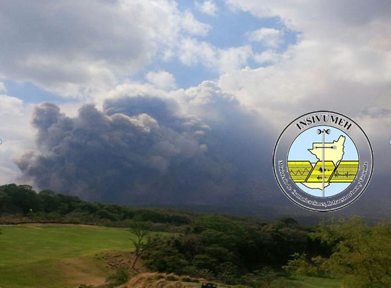 |
Figure 31. An ash cloud from a pyroclastic flow at Fuego on 7 February 2015 fills the horizon. Courtesy of INSIVUMEH and CONRED. |
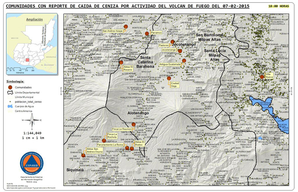 |
Figure 32. Communities (in red) that reported ashfall from Fuego on 7 February 2015. Courtesy of CONRED. |
On 8 February, although activity had decreased, the seismic network detected 30 explosions per minute. The explosions generated shock waves detected in areas 15 km S and SW. Lava flows up to 2 km long were observed in the El Jute and Trinidad drainages on the SE flanks, reaching vegetated areas and causing fires. Sixteen MODVOLC thermal alert pixels were recorded on 8 February; they continued on 9, 11-13 and 17 February before a 10 day break. INSIVUMEH noted that by 9 February activity levels had subsided with weak to moderate explosions producing ash plumes that rose 550 m above the summit and drifted 8-10 km NW (figure 33).
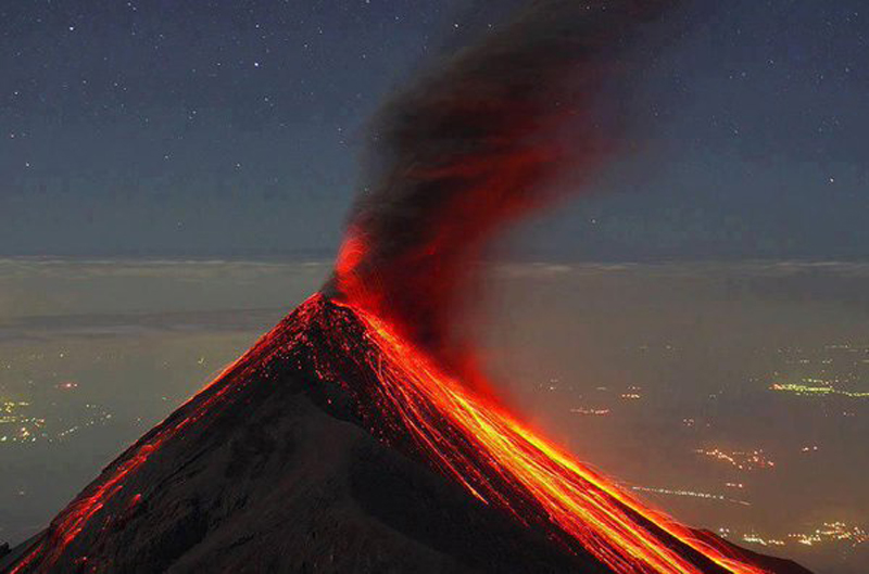 |
Figure 33. Ash plumes and incandescence at Fuego on 9 February 2015. Courtesy of twitter user JL@parachico, (https://twitter.com/search?q=Volcan Fuego 2015&src=typd) |
More intense activity returned on 16 February with 4-6 ash-bearing explosions per hour. The Washington VAAC reported the plumes at 4.9 km altitude, although INSIVUMEH noted pilot reports of ash at 7-9 km altitude. Ash fell in many villages to the NW, W, S, and SE more than 15 km from the summit. By 19 February, the ash plumes extended up to 150 km S of the summit. Intermittent emissions with dense ash plumes continued to rise from Fuego and disperse through 22 February.
A new effusive episode began on 28 February 2015 when lava fountains rose 300-400 m above the summit. A strong MODVOLC thermal alert signal persisted with multiple pixels through 3 March; afterwards MODVOLC pixels only appeared on six additional days during the month. One lava flow traveled 1.6 km S down the Trinidad drainage and another traveled 600 m W down the Santa Teresa drainage. Ash plumes also rose up to 1.25 km above the crater and drifted 35 km W generating ashfall in communities to the SW. Numerous ash plumes continued intermittently; VAAC reports were issued on 16 days during the month, through 24 March.
Hot spots appeared in satellite data numerous times during April 2015. Incandescent tephra was ejected 150-200 m above the crater. Block avalanches continued from the end of a new 300-m-long lava flow in the Trinidad drainage on 17 April. MODVOLC thermal alert pixels appeared on 12 days through 26 April, with large multi-pixel alerts on 17 and 18 April. According to INSIVUMEH, ash plumes continued rising 650-850 m above the crater and drifting 8-11 km S, SW, and W, but VAAC reports of ash only appeared on 17 and 18 April.
Far fewer MODVOLC thermal alerts were issued during only five different days spanning 5-31 May 2015. The Washington VAAC issued reports of ash plumes on 13, 15, 17, and 18 May. INSIVUMEH noted an increased number and intensity of explosions briefly during 14-15 May; ash plumes rose 450-750 m above the crater and drifted 10-12 km W and SW. They also reported a S-flank lava flow on 18 May. Ashfall was reported in the communities within 10 km SW of the summit. Incandescent material was ejected 150-200 m above the crater, causing block avalanches in drainages on the S and SW.
Strombolian activity again increased during June 2015, ejecting material 300 m above the crater for 30 hours during 4-6 June. Ash plumes rose to around 1 km above the summit and drifted 10-15 km S and SW. During this episode, lava flows traveled 600 and 1,200 m down the Santa Teresa and Trinidad drainages. Two cinder cones within the crater were reported on 6 June. A lahar was detected on 12 June that was 25 m wide and 2-3 m deep, travelling S down the Trinidad drainage carrying abundant volcanic material and blocks 1-2 m in diameter. MODVOLC thermal alerts were captured on 16 days during June. The Washington VAAC reported ash plumes from explosions on 5, 6, and 28 June with altitudes below 4.8 km and ashfall within 10 km in many areas, including La Soledad (11 km N) and Acatenango (12 km NW). During 29-30 June a 300-m-long lava flow was visible in the Las Lajas drainage on the SE flank.
Based on INSIVUMEH notices, CONRED reported that for a 30-hour period during 30 June-1 July 2015 activity at Fuego was at a high level, characterized by explosions, high-temperature pyroclastic flows (that began on 1 July), and ashfall. Ash plumes rose 4.8 km above the crater and drifted 25 km W and NW, producing ashfall in 22 local communities. An SO2 plume drifting NW was captured by the OMI instrument on the Aura satellite on 1 July (figure 34). The majority of material deposited by pyroclastic flows was located in the Las Lajas drainage where the flow reached 4-5 km in length. People in the La Reunion area near the river bed were evacuated. Nine MODVOLC thermal alert pixels were captured on 1 July, and 10 on 2 July, corroborating the high-temperature pyroclastic flows reported by CONRED. Only single thermal alert pixels were captured after that on 14, 25, and 29 July. The Washington VAAC reports issued on 1, 2, 6, and 14 July included reports of ash emissions to 4.9 km extending up to 55 km SW.
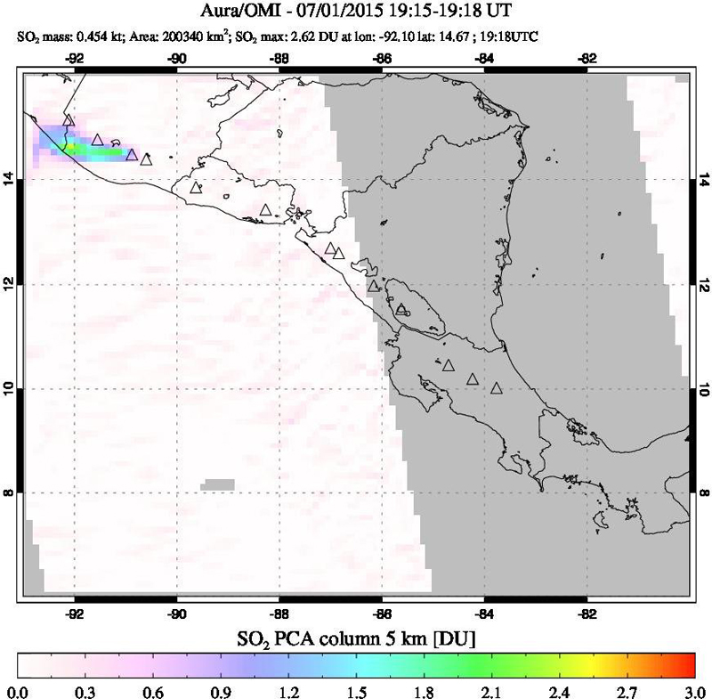 |
Figure 34. An SO2 plume drifting W from Fuego on 1 July 2015 during a phase of high eruptive activity. Courtesy of NASA GSFC. |
Although there were no VAAC reports issued between 14 July and 1 September 2015, the number of MODVOLC thermal alerts increased substantially during August from the previous month, with an especially large multi-pixel signature from 5 through 10 August. INSIVUMEH reported ash plumes rising to 4.2-4.6 m dispersing ash around 12 km in various directions several times during the month, as well as incandescent material rising to 200 m above the crater and sending block avalanches down the drainages on the S and W flanks.
Lava fountains, explosions, pyroclastic flows, and ashfall in surrounding areas picked up again beginning with a strong MODVOLC thermal alert signal on 30 August and lasted through 2 September. By the time activity decreased that day, the remnants of three lava flows were visible in the Santa Teresa, Trinidad and Las Lajas drainages on the S and SE flanks. There were no MODVOLC thermal alerts between 2 and 27 September, and no Washington VAAC reports between 2 and 29 September. During this time, INSIVUMEH reported moderate levels of explosions with ash-bearing plumes rising to 4.5 km altitude and drifting 10-12 km from the summit, dispersing minor amounts of ash to the villages within that radius.
The next pulse of activity began with three MODVOLC thermal alert pixels on 27 September 2015. Lava flows were persistent during October, as reported by INSIVUMEH and evidenced by the number of MODVOLC thermal alert pixels. Multi-pixels days were common between 27 September and 14 October, and again from 23-28 October. INSIVUMEH first reported lava flows on 4 October that were 400 m long in the Santa Teresa drainage and 300 m long in the Trinidad canyon. By 8 October the Trinidad canyon flow was 1.5 km long; the Santa Teresa canyon flow reached 1 km from the crater by 13 October. These flows were fed by Strombolian activity that had increased on 10 October, sending incandescent material 200 m above the crater (figure 35). Lava fountains during 13-14 October produced another lava flow in the Santa Teresa canyon that was 500 m long by 20 October.
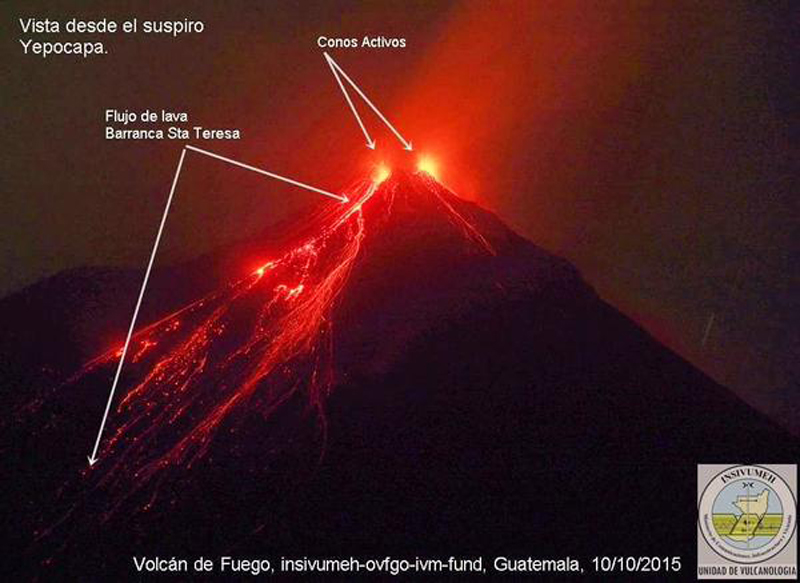 |
Figure 35. Lava flows in the Santa Teresa drainage at Fuego fed by Strombolian activity from the summit vents, 10 October 2015. View is from Yepocapa, 8 km NW. Courtesy of INSIVUMEH (http://www.insivumeh.gob.gt/erupcion_volcan_fuego.html) |
A new surge of activity beginning on 21 October through the end of the month generated 200-300 m-high lava fountains that advanced lava flows 1.5 km down the Santa Teresa, Trinidad, and Las Lajas drainages. Ash plumes during October reported by INSIVUMEH rose 450-1,200 m above the crater, dispersing ash to villages 10-12 km S and SW on several occasions; no ash plumes were observed by the Washington VAAC until 26 October when a plume rose to 5.2 km (1.4 km above the summit) and drifted SW.
On 1 November, the Washington VAAC reported discrete ash emissions at 5.2 km altitude drifting SW that dissipated within 50 km early in the day, and a second slightly higher plume later in the day that also dissipated quickly. Most of the rest of the ash plumes at the beginning of November were under 1 km in height above the summit and dispersed ash to communities within 12 km SW. Block avalanches from a 200-m-high fountain of incandescent ejecta traveled down Santa Teresa, Trinidad, and Las Lajas drainages early in the month.
New lava flows were reported in the Las Lajas and El Jute drainages beginning on 9 November 2015. A strong multipixel MODVOLC signal was captured during 7-11 November, including 12 pixels on 9 November. By 10 November the lava flows were 2.5 km long, and incandescent material was ejected 300 m high. Ashfall was reported in Panimache I and II, Morelia, Santa Sofia, El Porvenir, Sangre de Cristo and the municipality of San Pedro Yepocapa. Pyroclastic flows also descended the E flank on 10 November. The Washington VAAC reported an ash plume that morning below 5.2 km altitude drifting WSW at 15 knots. The plume was visible in satellite imagery extending for 110 km to the coast, and possibly out over the ocean to 185 km. By late in the day, ongoing lava flows and rockfalls were causing ash to rise to 6.1 km altitude and the winds were moving the ash out of the valleys around 140 km SW of Fuego. Ashfall was reported from communities as far as 90 km to the west including San Andrés Osuna (12 km SW), El Zapote (10 km S), Siquinala (20 km SW), Santa Lucia Cotzumalguapa (22 km SW), Mazatenango (87 km W), Patulul (30 km W), and Cocales (35 km W).
Strong multi-pixel MODVOLC signatures increased again between 25 November and 2 December and correlate with INSIVUMEH's reporting of large and strong explosions and new lava flows beginning on 29 November. The Washington VAAC reported ongoing emissions to 5.2 km altitude on 25 November which dissipated quickly. INSIVUMEH noted lava fountains rising to 500 m above the crater, feeding four lava flows that traveled 3 km down the Ceniza, Trinidad, Las Lajas, and Santa Teresa drainages on 29 November. A fifth lava flow was seen the next day along with small pyroclastic flows in the Honda drainage on the E flank. A new pulse of ash emissions to 5.5 km began on 30 November extending 45 km SW from the summit and continued through 1 December drifting more to the NW into S Mexico before dissipating.
Discrete ash emissions to 5.5 km altitude which quickly dissipated were observed in webcam imagery on 9 December 2015. Late the following day, another plume was spotted at the same elevation drifting 37 km NNE. Activity increased during the night of 14-15 December, characterized by an increased number of explosions (4-6 per hour). Ash plumes rose almost 1 km high and drifted 10-15 km NE, E, and SE. Two 800-m-long lava flows were active in the Trinidad and Santa Teresa drainages. Strong multi-pixel MODVOLC alerts appeared daily from 11-18 December. The Washington VAAC observed ongoing emissions on 16 December at 5.2 km altitude; they drifted as far as 280 km SW of Fuego. Lava flows remained active in the Las Lajas, Trinidad, and Santa Teresa drainages. Activity decreased toward the end of the month with modest ash emissions rising less than a kilometer above the summit, and incandescent material rising 150 m above the crater.
Table 12. Towns and drainages around Fuego and their distance and direction from the summit.
| Towns | Location |
| Acatenango | 12 km NW |
| Alotenango | 8 km ENE |
| Antigua | 18 km NE |
| Chimaltenango | 21 km NNE |
| Ciudad Vieja | 13.5 km NE |
| Cocales | 35 km W |
| El Porvenir | 8 km ENE |
| El Zapote | 10 km S |
| Ingenio los Tarros | 15 km SW |
| La Soledad | 11 km N |
| Los Yucales | 12 km SW |
| Mazatenango | 87 km W |
| Morelia | 10 km SW |
| Panimaché (I and II) | 8 km SW |
| Patulul | 30 km W |
| San Andrés Osuna | 12 km SW |
| San Miguel Duenas | 10 km NE |
| Sangre de Cristo | 10 km SW |
| Santa Lucia Cotzumalguapa | 22 km SW |
| Santa Sofía | 12 km SW |
| Siquinala | 20 km SW |
| Yepocapa | 9 km NW |
| Drainage / Ravine |
Direction |
| Ceniza | SSW |
| El Jute | SE |
| Honda | E |
| Las Lajas | SE |
| Santa Teresa | S |
| Seca | W |
| Taniluya | SW |
| Trinidad | S |
Geological Summary. Volcán Fuego, one of Central America's most active volcanoes, is also one of three large stratovolcanoes overlooking Guatemala's former capital, Antigua. The scarp of an older edifice, Meseta, lies between Fuego and Acatenango to the north. Construction of Meseta dates back to about 230,000 years and continued until the late Pleistocene or early Holocene. Collapse of Meseta may have produced the massive Escuintla debris-avalanche deposit, which extends about 50 km onto the Pacific coastal plain. Growth of the modern Fuego volcano followed, continuing the southward migration of volcanism that began at the mostly andesitic Acatenango. Eruptions at Fuego have become more mafic with time, and most historical activity has produced basaltic rocks. Frequent vigorous eruptions have been recorded since the onset of the Spanish era in 1524, and have produced major ashfalls, along with occasional pyroclastic flows and lava flows.
Information Contacts: Instituto Nacional de Sismologia, Vulcanologia, Meteorologia e Hydrologia (INSIVUMEH), Unit of Volcanology, Geologic Department of Investigation and Services, 7a Av. 14-57, Zona 13, Guatemala City, Guatemala (URL: http://www.insivumeh.gob.gt/); Coordinadora Nacional para la Reducción de Desastres (CONRED), Av. Hincapié 21-72, Zona 13, Guatemala City, Guatemala (URL: http://conred.gob.gt/www/index.php); Washington Volcanic Ash Advisory Center (VAAC), Satellite Analysis Branch (SAB), NOAA/NESDIS OSPO, NOAA Science Center Room 401, 5200 Auth Rd, Camp Springs, MD 20746, USA (URL: http://www.ospo.noaa.gov/Products/atmosphere/vaac/, archive at: http://www.ssd.noaa.gov/VAAC/archive.html); Hawai'i Institute of Geophysics and Planetology (HIGP), MODVOLC Thermal Alerts System, School of Ocean and Earth Science and Technology (SOEST), Univ. of Hawai'i, 2525 Correa Road, Honolulu, HI 96822, USA (URL: http://modis.higp.hawaii.edu/); NASA Earth Observatory, EOS Project Science Office, NASA Goddard Space Flight Center, Goddard, Maryland, USA (URL: http://earthobservatory.nasa.gov/); NASA Goddard Space Flight Center (NASA/GSFC), Global Sulfur Dioxide Monitoring Page, Atmospheric Chemistry and Dynamics Laboratory, 8800 Greenbelt Road, Goddard, Maryland, USA (URL: https://so2.gsfc.nasa.gov/); Tom Pfeiffer, Volcano Discovery (URL: http://www.volcanodiscovery.com/).