Report on Colima (Mexico) — August 2017

Bulletin of the Global Volcanism Network, vol. 42, no. 8 (August 2017)
Managing Editor: Edward Venzke.
Edited by A. Elizabeth Crafford.
Colima (Mexico) Multiple flows from the lava dome during October-December 2016; frequent explosions and ash emissions until 7 March 2017
Please cite this report as:
Global Volcanism Program, 2017. Report on Colima (Mexico) (Crafford, A.E., and Venzke, E., eds.). Bulletin of the Global Volcanism Network, 42:8. Smithsonian Institution. https://doi.org/10.5479/si.GVP.BGVN201708-341040
Colima
Mexico
19.514°N, 103.62°W; summit elev. 3850 m
All times are local (unless otherwise noted)
Frequent historical eruptions at México's Volcán de Colima (Volcán Fuego) date back to the 16th century and include vulcanian and phreatic explosions, lava flows, large debris avalanches, and pyroclastic flows. The latest eruptive episode began in January 2013. Extensive activity in 2015 included near-constant ash plumes with extensive ashfall, lava flows, and pyroclastic flows (BGVN 41:01). The eruption continued throughout 2016 until the last ash-bearing explosion was reported on 7 March 2017. This report covers the activity through June 2017. Most of the information for this report was gathered from the Unidad Estatal de Protección Civil de Colima (UEPCC), the Centro Universitario de Estudios e Investigaciones de Vulcanologia, Universidad de Colima (CUEIV-UdC), and the Washington Volcanic Ash Advisory Center (VAAC).
Colima was very active from January through April 2016 with hundreds of ash emissions, and a slow-growing lava dome that was first observed on 19 February. Activity decreased during May-September, although multiple explosions with ash plumes still took place most weeks during the period. On 30 September, the lava dome overflowed the crater rim, and sent a slow-moving lava flow and incandescent material down the SW flank. The lava flow continued to grow, reaching over 2 km in length by the end of October. A second lava flow appeared in mid-November, and advanced 1.7 km by early December. Strong ash-bearing explosions during December 2016-January 2017 sent plumes to heights of 4-6 km above the crater. Activity decreased during the second half of February; the last ash-bearing explosion was reported on 7 March 2017. Decreasing seismicity and minor landslides were reported through June 2017 with no further eruptive activity.
Incandescent activity during explosions in January 2016 sent glowing blocks down the flanks of Colima along with spectacular lightning in the ash plumes (figure 119). Ash emissions continued at Colima at a very high rate of multiple daily events, similar to December 2015 (figure 120). The Washington VAAC issued multiple advisories nearly every day during the month with information based on satellite imagery, wind data, webcam images, and notices from the México City Meteorological Watch Office (MWO). The ash plumes rose to altitudes of 4.3-6.7 km and most commonly drifted N or E. They generally drifted a few tens of kilometers before dissipating, but a few were still visible as far as 200 km from the summit.
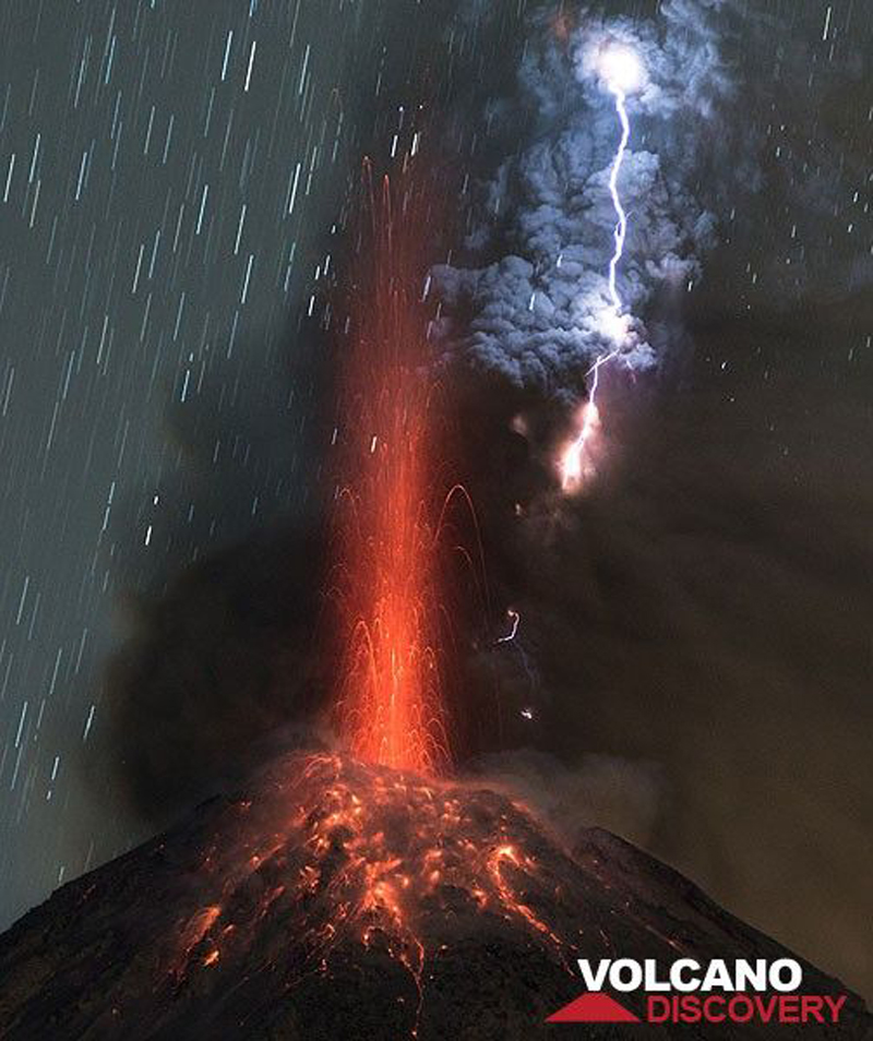 |
Figure 119. Eruption of ash plume and incandescent material at Colima on 3 January 2016. Courtesy of Volcano Discovery. |
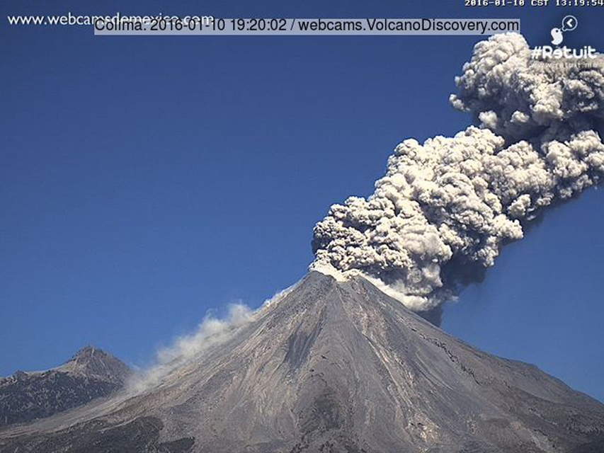 |
Figure 120. Ash eruption at Colima on 10 January 2016. Image from the Webcams de México Colima webcam located at the Laguna de Carrizalillos in Comala, about 25 km SW of the summit. |
Multiple daily ash advisories from the Washington VAAC continued during 1-9 February. They resumed on 14 February, and were intermittent for the rest of the month with similar altitudes and drift directions as those observed during January, but at a slightly lower frequency, decreasing towards the end of the month. On 19 February, CUEIV-UdC researcher Nick Varley observed a lava dome emerging from the floor of the crater (figure 121) during a helicopter overflight. It was estimated to be 25-30 m in diameter and 10 m high inside the almost 300-m-diameter, 50-m-deep summit crater. By 29 February, the dome had increased in size (figure 122), and fumarolic activity had also increased on the SE side of the summit crater.
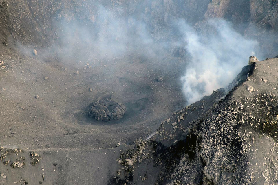 |
Figure 121. A new lava dome in the summit crater of Colima on 19 February 2016. Courtesy of CUEIV-UdC (http://www.ucol.mx/enterate/nota.php?docto=2473). |
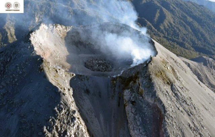 |
Figure 122. The lava dome at Colima photographed on 29 February 2016 was noticeably larger than when first photographed ten days earlier. Courtesy of SkyAlert (2 March 2016). |
Ash plume heights during March 2016 were slightly lower than during February (4.0-6.1 km altitude). Most of the plumes continued to drift NE or SE, and most dissipated within 50 km. During the first week of April, scientists observed fresh ashfall covering the dome at the center of the crater, which had not changed significantly since the previous overflight at the end of February. Persistent ash plumes continued throughout April with a three-minute-long ash emission recorded on 28 April by Colima's webcam.
The frequency of ash emissions decreased during May 2016 and further still during June 2016, when advisories from the Washington VAAC only appeared during five days of the month (1, 4, 13, 23, 30); the plume heights remained similar to previous months, except for a 16 May plume observed moving ENE at 7.6 km. After a two week pause, ash emissions resumed on 17 July with plume heights ranging from 4.3 to 7.3 km altitude through the end of the month. During the second half of August and for part of September, intermittent plumes did not exceed 6.1 km altitude, and dissipated within a few tens of kilometers of the summit.
The Unidad Estatal de Protección Civil de Colima reported that on 26 September seismicity at Colima increased, and incandescence appeared at the crater. On 27 September, small landslides originating from the growing lava dome traveled 100 m down the S flank. By the evening of 30 September, the webcam showed intense activity and crater incandescence as lava spilled over the crater rim and flowed down the SW flank (figure 123). An intense thermal anomaly was visible in short-wave infrared satellite images. An ash plume detected on 1 October in satellite images drifted almost 40 km S and SW; the webcam recorded explosions and pyroclastic flows down the flanks. The OMI instrument on the Aura satellite also recorded significant SO2 plumes drifting W and SW from Colima on 30 September and 1 October (figure 124).
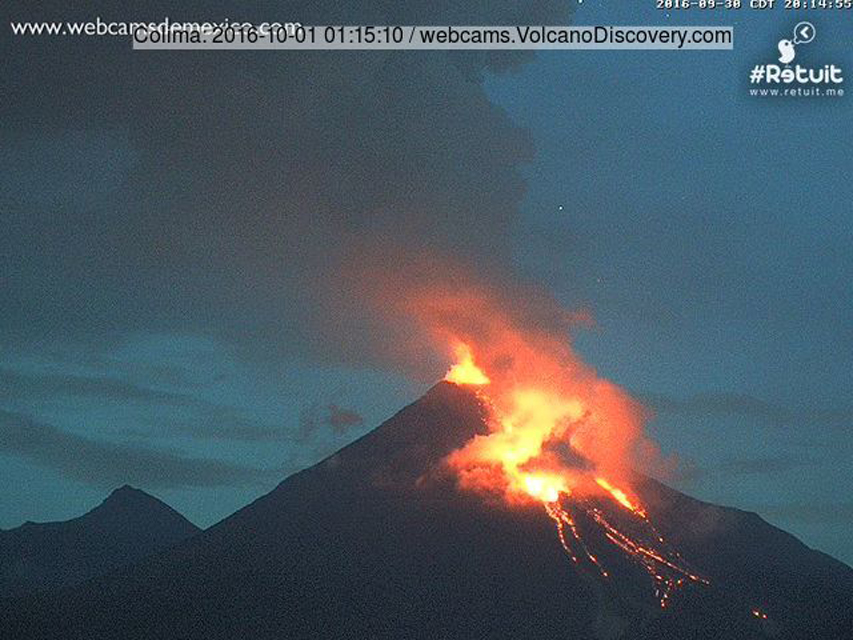 |
Figure 123. Intense activity at Colima during the late evening of 30 September 2016 (2014 CST), as a new lava flow emerged from the summit crater and moved down the SW flank. Image from the Webcams de México Colima webcam located at the Laguna de Carrizalillos in Comala, about 25 km SW of the summit. |
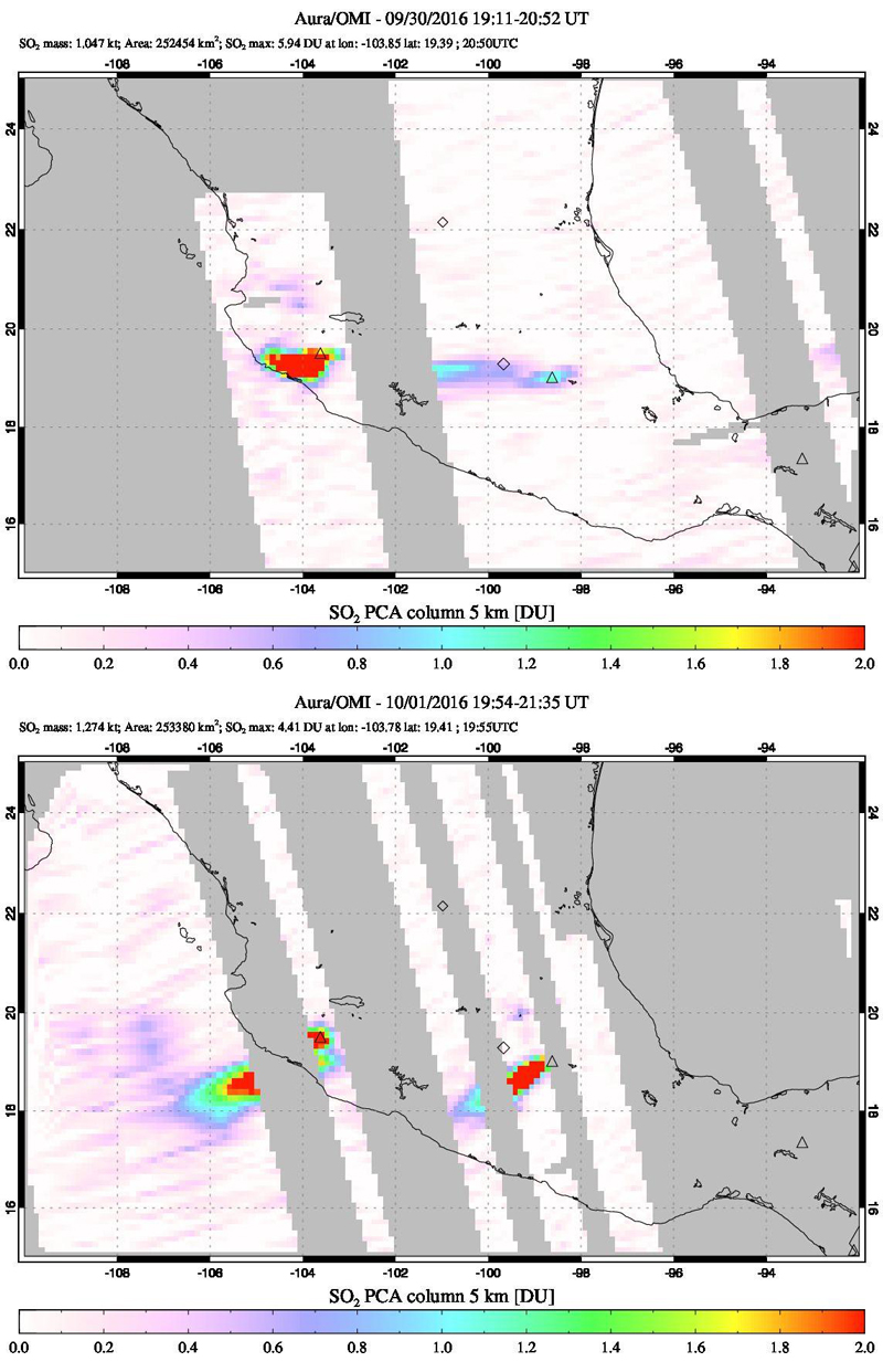 |
Figure 124. Sulfur dioxide plumes from Colima were captured by the OMI instrument on the Aura satellite on 30 September (upper) and 1 October 2016 (lower). Colima is on the left (west) side, near the coast. The other SO2 plume in central Mexico on the 1 October is from Popocatépetl. The red pixels indicate Dobson Unit (DU) values greater than 2. DU are a measure of molecular density of SO2 in the atmosphere. Courtesy of NASA Goddard Space Flight Center. |
According to news articles (Noticieros Televisa), during 29 September-1 October gas-and-ash plumes rose 4 km and caused ashfall in nearby areas, including La Becererra, La Yerbabuena, San Antonio, and El Jabali in the municipality of Comala (26 km SW), Montitlán in the municipality of Cuauhtémoc (34 km NW), and Juan Barragan in Tonila, Jalisco (14 km SE). On 1 October the Colima State government stated that the communities of La Yerbabuena (80 people) and La Becerrera (230 people) were preemptively evacuated, and an exclusion zone was extended to 12 km on the SW side. A news article noted that Juan Barragan was also evacuated.
The lava flow continued down the flank with incandescent rockfalls (figure 125) and occasional pyroclastic flows; by 4 October it had reached the base of the cone. The volume of the lava dome was estimated to have exceeded 1.2 million cubic meters (figure 126). By 8 October 2016, the lava flow was about 2,000 m long and 270 m wide at its front at the base of the cone. The Washington VAAC reported a strong hotspot consistent with the lava flow in satellite imagery on 9 October. On 13 October, they noted an ash plume that had drifted over 200 km W from the summit. Strong, multi-pixel, daily thermal alerts were issued from MODVOLC during 1-14 October. On 21 October, UEPCC reported that lava continued to flow down the S flank. It was 2.3 km long, 320 m wide, and had an estimated volume of 21 million m3.
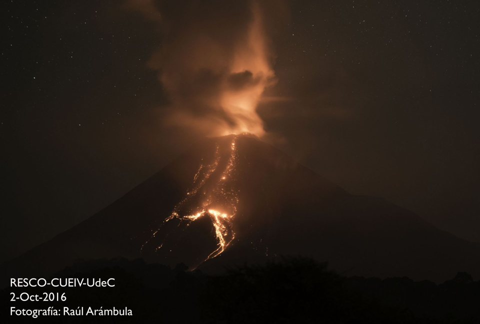 |
Figure 125. A lava flow descends the S flank of Colima on 2 October 2016. Image by Raúl Arámbula, courtesy of Red Sismologica Telemetrica del Estado de Colima-Centro Universitario de Estudios e Investigaciones de Vulcanologia-Universidad de Colima (RESCO-CUEIV-UdeC). |
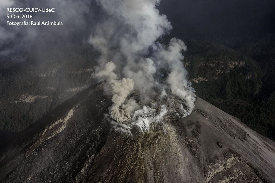 |
Figure 126. The lava dome overflowing the summit crater at Colima on 5 October 2016. Image by Raúl Arámbula, courtesy of RESCO-CUIEV-UdeC. |
Multiple ash plumes rose to altitudes of 5.5-8.2 km and drifted 25-40 km S, SW, and W during 2-4 October. Ashfall was reported in areas on the S and SW flanks. Ash explosions were also frequent throughout the rest of October, with plumes rising to altitudes of 4.3-7 km on many days (figure 127), until they ceased on 4 November for several weeks.
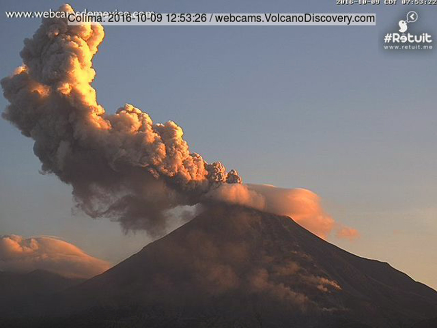 |
Figure 127. Ash explosion at Colima on 9 October 2016. Steam in the foreground is from the lava flow travelling down the SW flank. Image from the Webcams de México Colima webcam located at the Laguna de Carrizalillos in Comala, about 25 km SW of the summit. |
Effusive activity increased again at the very end of October 2016 with the growth of a new lava dome inside the summit crater. By 17 November, a new lava flow was also visible on the S flank (figure 128); it was reported to be about 500 m long by 20 November. After intermittent MODVOLC thermal alerts during late October and early November, they intensified with daily multi-pixel alerts between 15 November and 1 December.
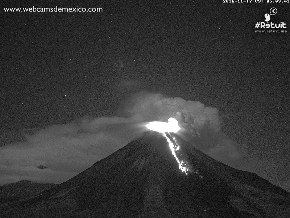 |
Figure 128. A new lava flow on the S flank of Colima on 17 November 2016. Image from the Webcams de México Colima webcam located at the Laguna de Carrizalillos in Comala, about 25 km SW of the summit. |
During 26-28 November 2016, a brief episode of ash emissions sent plumes to 4.9-5.5 km altitude that drifted W, N, and NE as far as 75 km before dissipating. Observations of Colima made on 5 December by UEPCC during a helicopter overflight indicated that the lava flow on the S flank was slowing its advance, and had reached about 1,700 m in length (figure 129).
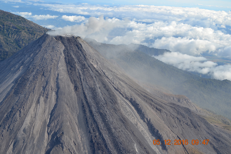 |
Figure 129. The lava flow on the S flank of Colima had reached 1.7 km in length on 5 December 2016. Courtesy of UEPCC. |
A new series of strong explosions with abundant ash emissions began on 7 December that continued through the end of the month. Multiple daily ash emissions appeared in both the webcam and satellite imagery. The plume on 8 December rose to 7.3 km and extended about 185 km NE of the summit near Lago de Chapala before dissipating. Incandescence during the explosions was visible at night, and glowing blocks were common on the upper flanks.
Ash clouds from multiple emissions were observed drifting W to WSW on 14 December at altitudes from 6.1 to 7.9 km (about 4 km above the summit). These plumes were visible 370 km WSW of the summit the next day. Plumes rose as high as 9.1 km altitude on 15 December, and spread N and NW. A series of strong, multiple daily explosions during 16-18 December included some of the strongest explosions since July 2015 (figure 130). Many of the multiple daily explosions during 19-31 December had plumes rising over 7 km in altitude and drifting over 100 km from the summit before dissipating. MODVOLC thermal alerts appeared on 13 days during December 2016.
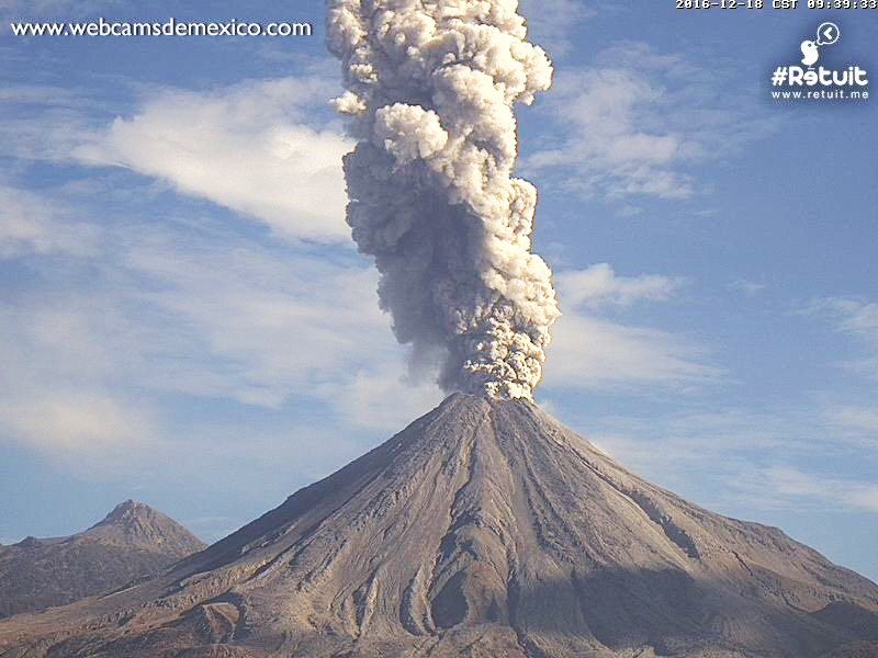 |
Figure 130. A strong explosion at Colima on 18 December 2016. Image from the Webcams de México Colima webcam located at the Laguna de Carrizalillos in Comala, about 25 km SW of the summit. |
Frequent strong explosive activity continued during January 2017. For the first three weeks of the month, the multiple daily plumes rose to altitudes of 4.6-7.6 km, drifting in multiple directions, some as far as 135 km. The UEPCC reported that at 0027 on 18 January a moderate-to-large explosion ejected incandescent material as far as 2 km onto the W, SW, SE, and N flanks. Based on webcam and satellite images, the México City MWO, and pilot observations, the Washington VAAC reported that during 18-24 January ash plumes rose to altitudes of 4.1-6.7 km and drifted in multiple directions. On 19 January, strong explosions were recorded by the webcam and noted by the Jalisco Civil Protection Agency (figure 131); they also reported ashfall in Comala and Cuauhtémoc. A strong thermal anomaly was identified in satellite images. Remnant ash clouds from the explosions were centered about 350 km SE on 20 January. A large ash plume rose to an altitude of 10.7 km on 23 January and drifted NE; several plumes that rose to over 7 km altitude were reported through the end of January. MODVOLC thermal alerts were issued on 11 days during January, but no further alerts appeared through June 2017.
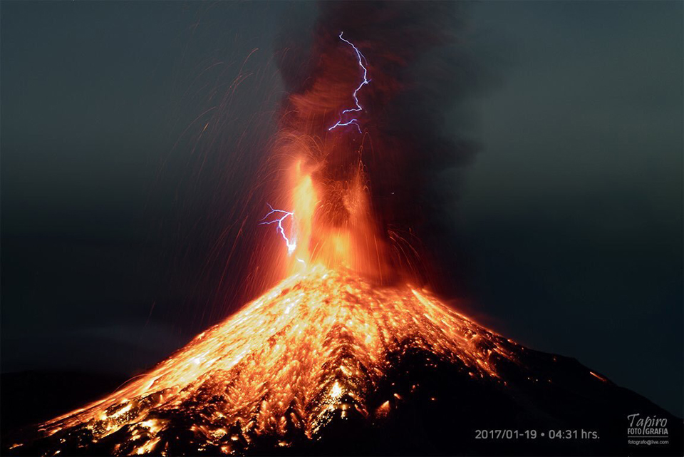 |
Figure 131. Eruption at Colima at 0431 on 19 January 2017. Courtesy of Sergio Tapiro. |
The CUEIV-UdC reported that a large explosion at 1732 on 3 February 2017 generated an ash plume that rose 6 km above the crater rim and drifted SSW (figure 132). The Washington VAAC reported the plume at 7.6 km altitude (3.7 km above the crater) shortly before midnight on 4 February. The CUEIV-UdC also noted that a small pyroclastic flow traveled down the E flank. Their report stated that the internal crater was about 250 m in diameter and 50-60 m deep; previous lava domes had been destroyed in late September and mid-November 2016.
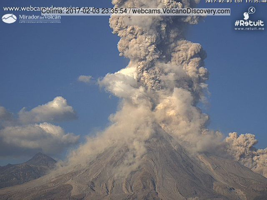 |
Figure 132. An explosion at Colima on 3 February 2017 caused an ash plume that the Universidad de Colima reported as rising to six km above the crater, drifting SSW. A small pyroclastic flow descended the E flank. Image from the Webcams de México Colima webcam located at the Laguna de Carrizalillos in Comala, about 25 km SW of the summit. |
A brief period of low-intensity explosions during 10-16 February 2017 generated ash plumes reported by the Washington VAAC at 4-5.2 km altitude. There were no further aviation alerts issued during February. According to CUEIV-UdC, a few low-intensity explosions occurred during 3-16 March. The ash plume on 7 March rose about 2 km above the crater and drifted SW. During an overflight in the middle of March, researchers from CUEIV-UdC noted degassing from small explosion craters on the floor of the main crater; there was no evidence of effusive activity or growth of a new dome. After the middle of March, seismicity steadily decreased; CUEIV-UdC reported landslides every week through June, but no additional ash emissions were reported.
The MIROVA radiative power plot of the MODIS thermal anomaly data clearly shows the thermal activity at Colima during September 2016-February 2017 (figure 133).
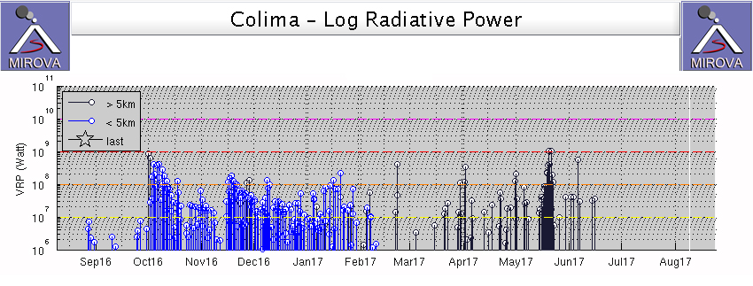 |
Figure 133. MIROVA log radiative power data from MODIS thermal anomaly satellite information clearly shows the strong thermal anomalies from the lava flows at Colima during September 2016-February 2017. The thermal anomalies shown in black after February 2017 are not located on the edifice and are not related to volcanic activity. Courtesy of MIROVA. |
Geological Summary. The Colima complex is the most prominent volcanic center of the western Mexican Volcanic Belt. It consists of two southward-younging volcanoes, Nevado de Colima (the high point of the complex) on the north and the historically active Volcán de Colima at the south. A group of late-Pleistocene cinder cones is located on the floor of the Colima graben west and east of the complex. Volcán de Colima (also known as Volcán Fuego) is a youthful stratovolcano constructed within a 5-km-wide scarp, breached to the south, that has been the source of large debris avalanches. Major slope failures have occurred repeatedly from both the Nevado and Colima cones, producing thick debris-avalanche deposits on three sides of the complex. Frequent recorded eruptions date back to the 16th century. Occasional major explosive eruptions have destroyed the summit (most recently in 1913) and left a deep, steep-sided crater that was slowly refilled and then overtopped by lava dome growth.
Information Contacts: Unidad Estatal de Protección Civil de Colima (UEPCC), Roberto Esperón 1170 Col. de los Trabajadores, C.P. 28020 (URL: http://www.proteccioncivil.col.gob.mx/); Centro Universitario de Estudios e Investigaciones de Vulcanologia (CUEIV-UdC), Universidad de Colima, Colima, Col. 28045, México; Centro Universitario de Estudios Vulcanologicos y Facultad de Ciencias de la Universidad de Colima, Avenida Universidad 333, Colima, Col., 28045 México (URL: http://portal.ucol.mx/cueiv/); Washington Volcanic Ash Advisory Center (VAAC), Satellite Analysis Branch (SAB), NOAA/NESDIS OSPO, NOAA Science Center Room 401, 5200 Auth Rd, Camp Springs, MD 20746, USA (URL: http://www.ospo.noaa.gov/Products/atmosphere/vaac/, archive at: http://www.ssd.noaa.gov/VAAC/archive.html); Hawai'i Institute of Geophysics and Planetology (HIGP), MODVOLC Thermal Alerts System, School of Ocean and Earth Science and Technology (SOEST), Univ. of Hawai'i, 2525 Correa Road, Honolulu, HI 96822, USA (URL: http://modis.higp.hawaii.edu/); MIROVA (Middle InfraRed Observation of Volcanic Activity), a collaborative project between the Universities of Turin and Florence (Italy) supported by the Centre for Volcanic Risk of the Italian Civil Protection Department (URL: http://www.mirovaweb.it/); NASA Goddard Space Flight Center (NASA/GSFC), Global Sulfur Dioxide Monitoring Page, Atmospheric Chemistry and Dynamics Laboratory, 8800 Greenbelt Road, Goddard, Maryland, USA (URL: https://so2.gsfc.nasa.gov/); Webcams de México (URL: http://www.webcamsdemexico.com/); Tom Pfeiffer, Volcano Discovery (URL: http://www.volcanodiscovery.com/); SkyAlert, Twitter (@SkyAlertMx) (URL: https://twitter.com/SkyAlertMx/status/705188862318882816); Sergio Tapiro, Twitter (@tapirofoto); Noticieros Televisa (URL: http://noticeros.televisa.com).