Report on Fuego (Guatemala) — November 2017

Bulletin of the Global Volcanism Network, vol. 42, no. 11 (November 2017)
Managing Editor: Edward Venzke.
Edited by A. Elizabeth Crafford.
Fuego (Guatemala) Five eruptive episodes and destructive lahars, January-June 2017
Please cite this report as:
Global Volcanism Program, 2017. Report on Fuego (Guatemala) (Crafford, A.E., and Venzke, E., eds.). Bulletin of the Global Volcanism Network, 42:11. Smithsonian Institution. https://doi.org/10.5479/si.GVP.BGVN201711-342090
Fuego
Guatemala
14.4748°N, 90.8806°W; summit elev. 3799 m
All times are local (unless otherwise noted)
Guatemala's Volcán de Fuego was continuously active throughout 2016, and has been erupting since 2002. Historical observations of eruptions date back to 1531, and radiocarbon dates are confirmed back to 1580 BCE. These eruptions have resulted in major ashfalls, pyroclastic flows, lava flows, and damaging lahars. Daily explosions that generated ash plumes to within 1 km above the summit (less than 5 km altitude) were typical. In addition, there were 16 eruptive episodes that included Strombolian activity, lava flows, pyroclastic flows, and ash plumes rising above 5 km altitude (BGVN 42:10). Lahars flowed down several drainages during January-June, August, and September. Similar activity continued during January-June 2017 and included five eruptive episodes and numerous lahars. In addition to regular reports from the Instituto Nacional de Sismologia, Vulcanología, Meteorología e Hidrologia (INSIVUMEH), the Washington Volcanic Ash Advisory Center (VAAC) provides aviation alerts. Locations of many towns and drainages are listed in table 12 (BGVN 42:05).
Explosions with ash emissions continued daily at Fuego during January-June 2017; five episodes of increased activity generated higher ash plumes, lava flows, and pyroclastic flows (table 14). The first eruptive episode of the year occurred on 25-26 January, consisting of two lava flows and an 8.6-km-long pyroclastic flow. The next eruptive episode, during 24-25 February, also generated two lava flows and a 7-km-long pyroclastic flow. Numerous ash plumes during March rose to within 1 km of the summit, and incandescent blocks traveled more than 200 m from the crater, but no lava or pyroclastic flows were reported. Eruptive episode 3 began on 1 April and included three lava flows up to 2 km long, and an ash plume reported at 9.1 km altitude. Significant lahars affected four ravines near the end of the month. Pyroclastic flows affected five ravines during eruptive episode 4 during 4-5 May, along with two lava flows, 1.5 and 1.2 km long. The Washington VAAC reported an ash plume from this event at 12.2 km altitude. Major lahars occurred eight times during May, transporting blocks up to a meter in diameter down the major drainages. There were seven periods of increased activity during June. The period of activity during 5-6 June, designated Episode 5, generated two lava flows (2 and 3 km long) and a pyroclastic flow.
Table 14. Eruptive episodes at Fuego during January-June 2017. Data courtesy of INSIVUMEH and the Washington VAAC.
| Dates | Episode | Max Ash Plume altitude | Ash Plume drift | Ash Plume max distance | Ashfall report location | Lava Flow drainages | Lava Flow lengths | Incandescence above crater | Pyroclastic Flow Drainages |
| 25-26 Jan 2017 | 1 | 5.5 km | W, SW | 30 km | 30 km W, SW | Ceniza, Trinidad | 1,000 m | 300 m | Ceniza, 8.6 km |
| 24-25 Feb 2017 | 2 | 7.6 km | W, SW, NW, N, NE, E | 25 km | 20 km NE, E | Santa Teresa, Las Lajas | -- | 300 m | Trinidad, 7 km |
| 1-2 Apr 2017 | 3 | 9.1 km | NW, W, SW | 30 km | Sangre de Cristo, San Pedro Yepocapa, Santiago Atitlán, Chicacao, Mazatenango, and Retalhuleu. | Las Lajas, Santa Teresa, Trinidad | 2 km | 300 m | -- |
| 4-5 May 2017 | 4 | 6.0 km | S, SW, W, NW | 15 km | More than 25 km | Seca, Las Lahas | 1.5 km, 1.2 km | 200 m | Seca, Ceniza, Trinidad, El Jute, and Las Lajas |
| 5-6 Jun 2017 | 5 | 6 km | W, SE, NW | More than 20 km | San Pedro Yepocapa, Morelia, Santa Sofia, Panimaché, El Porvenir and Sangre de Cristo | Santa Teresa, Ceniza | 3 km, 2 km | 200 m | Santa Teresa |
Activity during January 2017. The last eruptive episode (16) of 2016, during 20-21 December, included Strombolian activity that produced three lava flows, a large pyroclastic flow, and ashfall in villages 10-12 km SW (BGVN 42:10). VAAC reports indicated ash emissions visible as far as 230 km SW during the episode. Intermittent ash emissions and thermal alerts were reported during the rest of December as well. Activity increased during January 2017, with ash falling mostly on the S and SW flanks. INSIVUMEH reported Vulcanian explosions on 3 and 4 January which contained abundant ash and sent plumes to 5 km above sea level that drifted NW, W, SW, and S (figure 60). Ashfall was reported in Sangre de Cristo, San Pedro Yepocapa, Santa Sofia, Morelia, Palo Verde Farm, Panimache I and II, La Rochelle, San Andrés Osuna, Siquinalá and Escuintla. Sounds and shockwaves were heard and felt 8 km from the volcano.
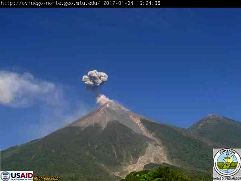 |
Figure 60. Ash emission at Fuego on 4 January 2017. Courtesy of INSIVUMEH (INFORME MENSUAL DE LA ACTIVIDAD DEL VOLCÁN DE FUEGO, ENERO 2017). |
The Washington VAAC reported ash emissions at 4.3 km altitude (500 m above the summit) on 1 January extending about 35 km W of the summit early in the day. A second plume rose to 5.5 km and drifted a similar distance SE. A third ash plume a few hours later was spotted at 4.6 km altitude drifting W. By late in the day on 3 January, a broken plume of gas and ash was visible in satellite imagery 300 km SW. A well-defined plume on 4 January extended 90 km SW at 4.9 km altitude. Emissions rose to 5.8 km altitude on 5 January. Daily ash plumes during 2-8 January rose to 4.3-5.8 km and generally drifted W or SW up to 50 km. They also reported intermittent ash emissions in satellite imagery on 11 January, and visible in the webcam on 22 January.
The first eruptive episode of the year began on 25 January 2017 with constant explosions generating an ash plume that rose to 4.5 km altitude and drifted W and SW. Incandescence was visible 200 m above the crater, a lava flow traveled 1,000 m down the Ceniza canyon, and block avalanches descended the Ceniza and Trinidad ravines. Ash emissions later reached 5.5 km altitude and drifted W and SW more than 30 km. Strombolian activity ejected material 300 m above the crater and sent bombs more than 300 m from the crater. A second lava flow traveled down the Trinidad ravine later in the day. The Washington VAAC reported ash emissions during 25-28 January 2017 that rose to 4.6-5.5 km altitude extending over 200 km W. During the early morning of 26 January, a pyroclastic flow descended 8.6 km down the Ceniza canyon. INSIVUMEH estimated the volume of the flow to be over 11,000,000 m3 (figure 61). Extensive new pyroclastic flow deposits were observed filling parts of the ravine. A light layer of ash covered the vegetation in La Rochela as a result of the pyroclastic flow. INSIVUMEH reported ashfall in San Pedro on 26 January.
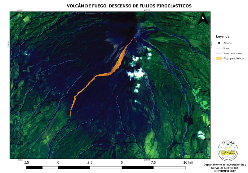 |
Figure 61. A pyroclastic flow at Fuego traveled 8.6 km down the Ceniza canyon during the early hours of 26 January 2017, part of the first eruptive episode of the year. The volume of the flow was measured by INSIVUMEH scientists as over 11,000,000 m3. Courtesy of INSIVUMEH (INFORME MENSUAL DE LA ACTIVIDAD DEL VOLCÁN DE FUEGO, ENERO 2017). |
Activity during February 2017. An increase in activity on 2 February resulted in weak and moderate explosions that lasted 5-10 minutes and generated ash plumes that rose to 4.5 km altitude. The plumes drifted 15 km W and ashfall was reported in San Pedro Yepocapa and Sangre de Cristo. During 31 January-4 February the Washington VAAC noted several ash emissions (figure 62). They rose to altitudes ranging from 3.7-4.9 km and drifted S and W. Ash was visible 180 km SW on 2 February.
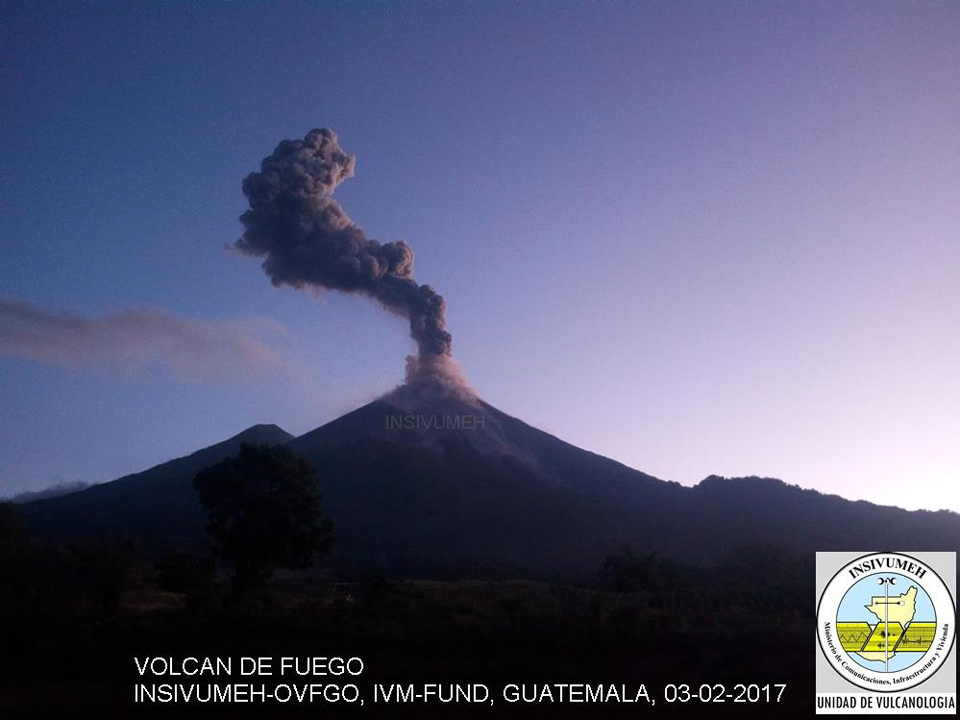 |
Figure 62. Ash emission at Fuego on 3 February 2017. Courtesy of INSIVUMEH (INFORME MENSUAL DE LA ACTIVIDAD DEL VOLCÁN DE FUEGO, FEBRERO 2017). |
On the morning of 24 February, eruptive episode 2 began with explosions and ash plumes rising to 4.6 km altitude and drifting W and SW. Explosions were heard by nearby residents every few minutes, and by the evening two lava flows were observed in the Santa Teresa and Las Lajas ravines. Incandescence reached 300 m above the crater and fell more than 300 m from the crater on the flanks, generating block avalanches. By the next morning ash plumes were observed at 5 km altitude drifting more than 25 km NW, N, NE and E. A pyroclastic flow descended the Trinidad ravine on the morning of 25 February, and traveled about 7 km. Ash on the SE flank was reported in El Rodeo, El Zapote, La Réunion, Alotenango, and San Vicente Pacaya (figure 63). On 25 February, the Washington VAAC reported large areas of dissipating ash moving in multiple directions. Ash emissions at 5-5.2 km altitude were drifting 65 km NE, at 5.8 km altitude they were drifting 130 km NE and also SE, at 6.4 km they were moving S, and another simultaneous plume was observed at 7.6 km drifting 30 km SW.
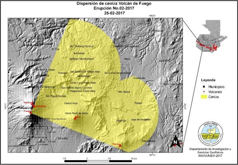 |
Figure 63. Ash dispersion map of the 24-25 February 2015 eruption episode 2 at Fuego. Courtesy of INSIVUMEH (INFORME MENSUAL DE LA ACTIVIDAD DEL VOLCÁN DE FUEGO, FEBRERO 2017). |
Activity during March 2017. Daily weak and moderate explosions characterized activity during March 2017. Incandescence rose to 250 m above the crater and generated bombs and block avalanches that traveled more than 200 m from the crater (figure 64), but no new lava or pyroclastic flows were reported. INSIVUMEH reported an average of 17 explosions per day during the month, which generated ash plumes that rose to 4.4-4.9 km. Block avalanches were observed in the lower part of the Las Lajas ravine. Ashfall was reported in San Pedro Yepocapa, Sangre de Cristo, Palo Verde, Santa Sofía, Morelia, and Panimaché I and II. Three to six explosions per hour were recorded on 9, 10, 27, 29, and 31 March. The Washington VAAC reported ash emissions during 8-10, and 13 March. Plumes were observed rising to 4.6 km and moving W, 4.9 km moving S and SE, and 5.8 km drifting 80 km SE during these days. Lahars were reported on 17 and 21 March in the Las Lajas, Santa Teresa, and Ceniza ravines. The road to the village of La Rochela was cut off for a few days by the lahar in the Ceniza ravine.
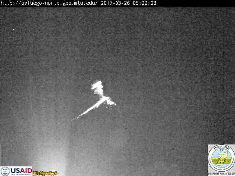 |
Figure 64. Explosions generated ash plumes and block avalanches often during March 2017 at Fuego, including on 26 March in the early morning when this webcam image was taken. Courtesy of INSIVUMEH (INFORME MENSUAL DE LA ACTIVIDAD DEL VOLCÁN DE FUEGO, MARZO 2017). |
Activity during April 2017. Persistent degassing during April sent steam emissions to 4.1-4.5 km altitude that dispersed in almost every direction, due to numerous changes in wind direction throughout the month. Weak to moderate Strombolian explosions created ash plumes that rose to 4.2-5.0 km and drifted primarily W and SW. Incandescence from the explosions was visible primarily at night and in the early morning around 100-300 m above the crater. The explosions also generated block avalanches that traveled more than 300 km from the summit. There were two spikes in explosive activity during April. The first, on 1 April, led to eruptive episode 3. The second, on 21 April, was less intense. These periods averaged 5-7 explosions per hour with ash plumes rising to 4.6-4.9 km and drifting in various directions.
Eruptive episode 3 began around midday on 1 April 2017, with Strombolian explosions that produced ash plumes up to 5 km that drifted more than 30 km NW, W, and SW; it lasted for about 16 hours. Ash fell in Sangre de Cristo, San Pedro Yepocapa, Santiago Atitlán, Chicacao, Mazatenango, and Retalhuleu. Lava flows traveled down the Las Lajas, Santa Teresa and Trinidad ravines as far as 2 km. The eruption was categorized by INSIVUMEH as a VEI 2 event with moderate to strong Strombolian explosions. The Washington VAAC reported an ash plume on 1 April that rose to 6.4 km altitude. The densest part of the plume was moving NW with some material fanning out to the NNE. They later revised their report with information that a new emission had risen to 9.1 km altitude and drifted NE. Ash emissions continued the next day with plumes moving NNW at 5.5 km and NNE at 8.2 km; bright incandescence appeared at the summit along with elevated seismicity. By the end of 2 April, the higher plume was diffuse as it dissipated over the far western Caribbean of the coast of Belize and Yucatan.
The Washington VAAC reported an ash emission to 4.5 km altitude on 21 April that extended 30 km NE of the summit. Occasional puffs of ash continued throughout the day and rose to 4.9 km altitude later in the day. By the next day, a plume was visible at 4.6 km extending 80 km E; it was later reported at 4.9 km altitude. By 23 April a faint plume extended 90 km S before dissipating. INSIVUMEH also reported ashfall in Palo Verde Farm, Santa Sofía, Morelia, and Panimaché I and II other times during the month.
Significant lahars affected several ravines on 20, 23, and 24 April 2017. Rain, hail and snowfall caused a lahar in Ceniza Canyon on 20 April (figure 65). On 23 April, lahars flowed down the Santa Teresa, Trinidad, Ceniza and Las Lajas ravines after 160 mm of rainfall in three days. These ravines are tributaries of the larger Pantaleón, Achíguate, and Guacalate rivers. Another lahar on 24 April in Ceniza Canyon was audible more than 1 km from the ravine.
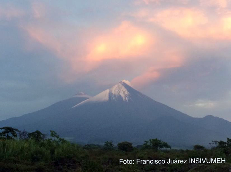 |
Figure 65. View of Fuego after an intense rain and hailstorm on 20 April 2017 that caused a lahar in Ceniza Canyon. Photo by Francisco Juarea, courtesy of INSIVUMEH (INFORME MENSUAL DE LA ACTIVIDAD DEL VOLCÁN DE FUEGO, Abril 2017). |
Activity during May 2017. Eruptive episode 4 began on 4 May 2017. A lava flow on the NE flank descended the Seca ravine for 1,500 m (figure 66). Explosions increased to 5-7 per hour, and were visible 200 m above the summit. Another lava flow descended 1.2 km down the Las Lajas ravine. Pyroclastic flows descended Barranca Seca, filling the channel and overflowing to the SE into Rio Mineral. They also affected Ceniza, Trinidad, El Jute, and Las Lajas canyons (figure 67) raising the imminent threat of lahars in these drainages. INSIVUMEH estimated that 14 million cubic meters of material was emplaced from the pyroclastic flows.
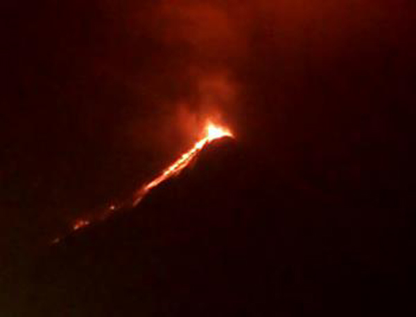 |
Figure 66. A lava flow descends the Barranca Seca at Fuego on 4 May 2017 during eruptive episode 4. Courtesy of INSIVUMEH (INFORME MENSUAL DE LA ACTIVIDAD DEL VOLCÁN DE FUEGO, Mayo 2017). |
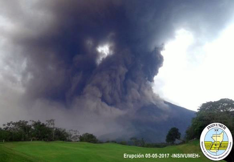 |
Figure 67. Pyroclastic flows descend several drainages on the SE slope of Fuego on 5 May 2017 during eruptive episode 4, as viewed from la Finca la Reunión. Courtesy of INSIVUMEH (INFORME MENSUAL DE LA ACTIVIDAD DEL VOLCÁN DE FUEGO, Mayo 2017). |
INSIVUMEH reported ash emissions during this episode as high as 6 km altitude. The ash dispersed S, SW, W and NW, and ashfall was reported in communities more than 25 km from the crater (figure 68). Energy levels decreased after about 24 hours. INSIVUMEH characterized the event as a VEI 3 eruption. The Washington VAAC was unable to observe the activity in satellite imagery due to cloud cover until the morning of 5 May, when they reported ash plumes moving SW at about 4.6 km altitude and also ENE at 5.5 km altitude. They reported a new, much higher ash plume midday on 5 May at 12.2 km altitude that was drifting E at about 50 km per hour, in addition to the lower level emissions around 4.6 km that drifted SW which generated ashfall in the immediate vicinity of the volcano. The Washington VAAC reported another ash emission on 7 May that rose to 4.9 km altitude and drifted SW about 10 km from the summit. Another plume appeared in satellite imagery the next day moving SW at 4.6 km about 15 km from the summit. The Washington VAAC reported no additional plumes until 31 May when satellite imagery showed a plume with possible ash extending about 25 km NE from the summit at 4.9 km altitude. Ashfall was reported during the month in Morelia, La Rochela, Santa Sofia, Sangre de Cristo, Palo Verde farm, Panimache I and II, San Pedro Yepocapa and Escuintla.
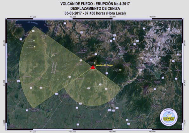 |
Figure 68. Ashfall from eruptive episode 4 at Fuego during 4-5 May 2017 was reported in communities more than 25 km from the volcano, and dispersed S, SW, W, and NW. Courtesy of INSIVUMEH (INFORME MENSUAL DE LA ACTIVIDAD DEL VOLCÁN DE FUEGO, Mayo 2017). |
Moderate and strong lahars were recorded on six days in May (figure 69). Five took place in Seca barranca (13, 14, 19, 23, and 27 May), one in the Ceniza ravine (14 May), and two in Las Lajas canyon (both on 29 May). They transported very fine-grained material that had the consistency of wet concrete, and included blocks up to one meter in diameter.
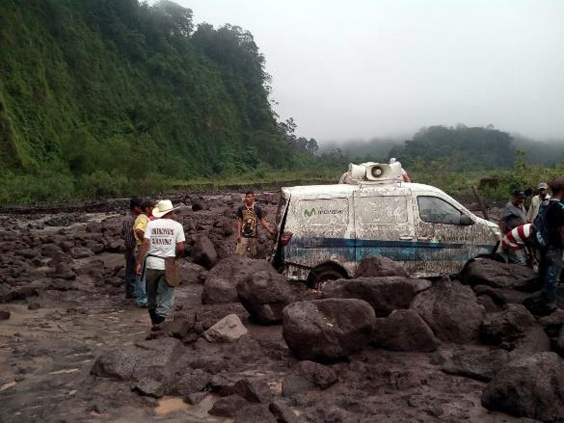 |
Figure 69. A vehicle trapped in a lahar at Fuego in May 2017 surrounded by blocks as large as one meter in diameter. Courtesy of INSIVUMEH (INFORME MENSUAL DE LA ACTIVIDAD DEL VOLCÁN DE FUEGO, Mayo 2017). |
Activity during June 2017. Weak and moderate daily explosions continued at Fuego during June 2017. They generated ash plumes that drifted more than 12 km, incandescence and block avalanches, and ashfall more than 30 km NW, W, and SW. Numerous lahars were also reported. The 20-25 daily explosions generally sent ash plumes to 4.2-4.5 km altitude that drifted mostly W and SW. The incandescence from Strombolian explosions generally extended 150-200 m above the crater (figure 70). Ashfall from these events was reported in in Morelia, Santa Sofia, Sangre de Cristo, La Rochela, and Panimache I and II.
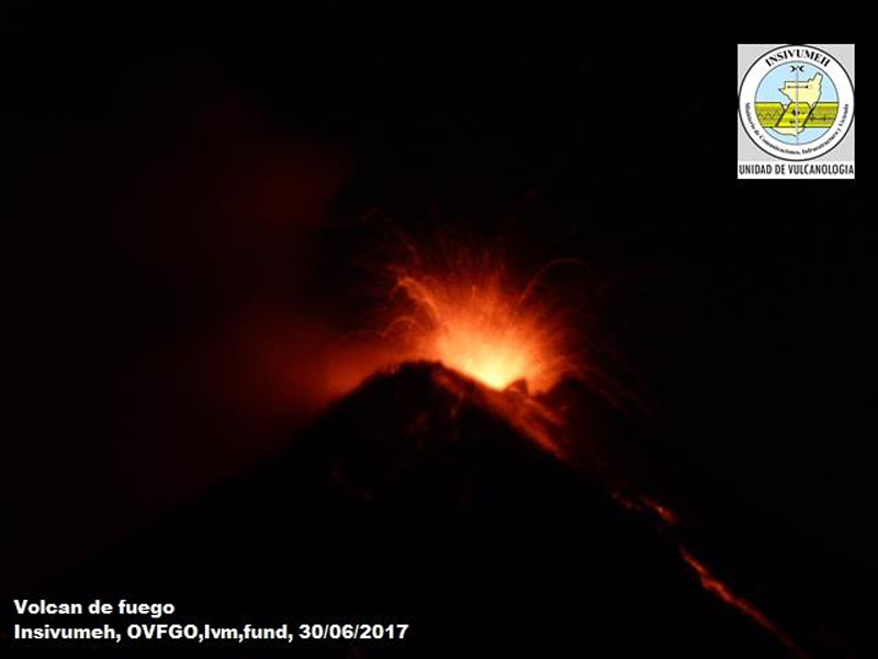 |
Figure 70. A Strombolian explosion on 30 June 2017 at Fuego reached 150-200 m above the crater and sent avalanche blocks down the flanks. This was typical behavior for the month of June. Courtesy of INSIVUMEH (INFORME MENSUAL DE LA ACTIVIDAD DEL VOLCÁN DE FUEGO, Junio 2017). |
There were seven periods of increased explosive activity during June 2017 (table 15), including eruptive episode 5. Many of the increases in energy levels were observed in the seismic record (figure 71) and reported by OVFGO (the Fuego Volcano Observatory). They noted an average of 5-8 explosions per hour during these events, and ash emissions rising to 4.6-4.9 km altitude, drifting W, SW, and S. None of the ash plumes reported by INSIVUMEH were observed by the Washington VAAC in satellite imagery due to weather clouds. The Washington VAAC did observe bright hotspots in shortwave imagery on 6 June.
Table 15. Periods of increased eruptive activity at Fuego during June 2017. Courtesy of INSIVUMEH (INFORME MENSUAL DE LA ACTIVIDAD DEL VOLCÁN DE FUEGO, Junio 2017).
| Date | Activity |
| 1 Jun 2017 | Ashfall in San Pedro Yepocapa; avalanche blocks descend more than 150 meters. |
| 5 Jun 2017 | Eruptive episode 5. Ashfall in San Pedro Yepocapa, Morelia, Santa Sofia, Panimaché, El Porvenir and Sangre de Cristo; lava flows 500 m down Barranca Santa Teresa. |
| 12 Jun 2017 | Ashfall in San Miguel Dueñas, Antigua Guatemala, and San Lucas Sacatepéquez. |
| 13 Jun 2017 | Ash dispersed NW and N more than 35 km. |
| 13 Jun 2017 | Ash dispersed NE and N more than 20 km. |
| 14 Jun 2017 | Ash dispersed more than 25 km NW and N. |
| 16 Jun 2017 | Ashfall in the villages of Panimache, Morelia, Santa Sofia and Santa Lucia Cotzumalguapa. |
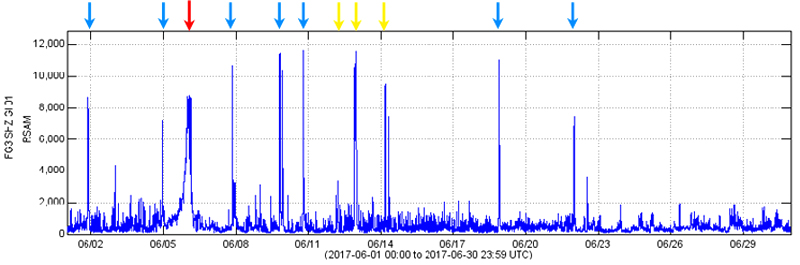 |
Figure 71. RSAM graph for Fuego during June 2017 shows spikes in seismic energy caused by eruptive episode 5 (red arrow), increases in explosive activity (yellow arrows), and several lahars (blue arrows). Courtesy of INSIVUMEH (INFORME MENSUAL DE LA ACTIVIDAD DEL VOLCÁN DE FUEGO, Junio 2017). |
Eruptive episode 5 for 2017 began during the late afternoon of 5 June. Moderate and strong Strombolian explosions generated an ash plume that rose to 6 km altitude and drifted more than 20 km W, SE, and NW from the crater. Sounds as loud as a freight train were reported nearby, and vibrations were felt in communities around the volcano. Lava flowed 3 km down the Santa Teresa ravine and 2 km down Ceniza canyon. Volcanic bombs rose 200 m high, and fell more than 300 m from the summit crater. Pyroclastic flows descended the Santa Teresa canyon on the W flank.
Thirteen lahars were reported during June (table 16). They descended the Santa Teresa, Mineral, Trinidad, Ceniza, Las Lajas, and El Jute ravines, tributaries of the Pantaleón, Achíguate and Guacalate rivers. Overflows from the drainages damaged several roads and river crossings in the region.
Table 16. Lahars at Fuego during June 2017. Courtesy of INSIVUMEH (INFORME MENSUAL DE LA ACTIVIDAD DEL VOLCÁN DE FUEGO, Junio 2017).
| Date | Barranca (ravine) |
| 1 Jun 2017 | Santa Teresa |
| 2 Jun 2017 | Santa Teresa (twice) |
| 4 Jun 2017 | Santa Teresa |
| 5 Jun 2017 | Santa Teresa |
| 7 Jun 2017 | Santa Teresa, Mineral |
| 9 Jun 2017 | Las Lajas, El Jute |
| 9 Jun 2017 | Las Lajas, El Jute, Ceniza |
| 10 Jun 2017 | Ceniza |
| 12 Jun 2017 | Santa Teresa, Mineral, Ceniza |
| 12 Jun 2017 | Ceniza, Pantaleon |
| 13 Jun 2017 | Ceniza, Santa Teresa, Mineral |
| 18 Jun 2017 | El Jute, Trinidad |
Satellite thermal data. The eruptive episodes reported by INSIVUMEH at Fuego during 2016 and the first half of 2017 are readily apparent in the MIROVA Log Radiative Power thermal data, and are also present going back at least to mid-2015 (figure 72). INSIVUMEH reported new lava flows and Strombolian activity each time (except for 2016 episode 8), which were the likely sources of the pulses of thermal activity. Details of the eruptive episodes for 2016 are discussed in BGVN 42:10 and 42:06.
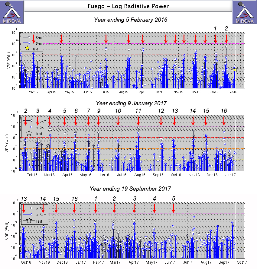 |
Figure 72. MIROVA thermal anomaly graphs of MODIS infrared satellite data spanning 5 February 2015-19 September 2017 illustrating the recurring nature of eruptive episodes at Fuego. INSIVUMEH described 16 episodes during 2016, and five episodes during January-June 2017, shown as numbers over the red arrows. Episode 8 for 2016 is not shown; it was primarily a pyroclastic flow which did not generate the same thermal signal caused by lava flows during the other episodes. Courtesy of MIROVA. |
Geological Summary. Volcán Fuego, one of Central America's most active volcanoes, is also one of three large stratovolcanoes overlooking Guatemala's former capital, Antigua. The scarp of an older edifice, Meseta, lies between Fuego and Acatenango to the north. Construction of Meseta dates back to about 230,000 years and continued until the late Pleistocene or early Holocene. Collapse of Meseta may have produced the massive Escuintla debris-avalanche deposit, which extends about 50 km onto the Pacific coastal plain. Growth of the modern Fuego volcano followed, continuing the southward migration of volcanism that began at the mostly andesitic Acatenango. Eruptions at Fuego have become more mafic with time, and most historical activity has produced basaltic rocks. Frequent vigorous eruptions have been recorded since the onset of the Spanish era in 1524, and have produced major ashfalls, along with occasional pyroclastic flows and lava flows.
Information Contacts: Instituto Nacional de Sismologia, Vulcanologia, Meteorologia e Hydrologia (INSIVUMEH), Unit of Volcanology, Geologic Department of Investigation and Services, 7a Av. 14-57, Zona 13, Guatemala City, Guatemala (URL: http://www.insivumeh.gob.gt/ ); Washington Volcanic Ash Advisory Center (VAAC), Satellite Analysis Branch (SAB), NOAA/NESDIS OSPO, NOAA Science Center Room 401, 5200 Auth Rd, Camp Springs, MD 20746, USA (URL: www.ospo.noaa.gov/Products/atmosphere/vaac, archive at: http://www.ssd.noaa.gov/VAAC/archive.html); MIROVA (Middle InfraRed Observation of Volcanic Activity), a collaborative project between the Universities of Turin and Florence (Italy) supported by the Centre for Volcanic Risk of the Italian Civil Protection Department (URL: http://www.mirovaweb.it/).