Report on Santa Maria (Guatemala) — December 2017

Bulletin of the Global Volcanism Network, vol. 42, no. 12 (December 2017)
Managing Editor: Edward Venzke.
Edited by A. Elizabeth Crafford.
Santa Maria (Guatemala) Slow growth of new lava dome, persistent ash plumes, and nearby ashfall, January-October 2017
Please cite this report as:
Global Volcanism Program, 2017. Report on Santa Maria (Guatemala) (Crafford, A.E., and Venzke, E., eds.). Bulletin of the Global Volcanism Network, 42:12. Smithsonian Institution. https://doi.org/10.5479/si.GVP.BGVN201712-342030
Santa Maria
Guatemala
14.757°N, 91.552°W; summit elev. 3745 m
All times are local (unless otherwise noted)
The dacitic Santiaguito lava-dome complex on the W flank of Guatemala's Santa María volcano has been growing since 1922. The youngest of the four vents in the complex, Caliente, has been actively erupting with ash explosions, pyroclastic, and lava flows for more than 40 years. During July-September 2016, daily weak ash emissions were punctuated weekly by stronger emissions that sent ash plumes to altitudes of 3.3-6 km, and numerous pyroclastic flows were reported (BGVN 42:07). A new lava dome appeared in October and had filled half of the crater by years end; the frequency of explosions increased to 25-35 per day by December 2016. Guatemala's INSIVUMEH (Instituto Nacional de Sismologia, Vulcanologia, Meterologia e Hidrologia) and the Washington VAAC (Volcanic Ash Advisory Center) provided regular updates on the continuing activity during the time period of this report from January-October 2017.
Activity at the Caliente dome was very consistent from January through October 2017. A lava dome that began growing during October 2016 continued to slowly increase in size. Its growth generated constant steam and gas emissions that rose 100-500 m above the dome, and daily explosions with ash that generally rose to 2.8-3.3 km altitude (200-800 m above the dome). Ashfall was reported almost daily in villages and farms within 5-12 km S and SW, including San Marcos Palajunoj, Loma Linda, Monte Bello, El Patrocinio, La Florida, El Faro, Patzulin, and others. There were 15-35 explosions per day throughout this time. As the lava dome within the Caliente summit crater increased in size, more block avalanches were observed traveling tens of meters down the flanks of Caliente, outside the crater rim. Several lahars affected the major drainages during May-October.
Fifteen to twenty small to moderate daily explosions with ash emissions were typical for the Caliente dome complex during most of January 2017, in addition to constant blue and white gas emissions from the top of the lava dome. This same pattern continued throughout February, when the new dome inside the summit crater continued to grow (figure 63). By March, the dome was large enough that occasional block avalanches of fresh lava reached outside the summit crater, and descended a few tens of meters onto the flanks; the lava dome, growing since October 2016, had not quite filled the crater (figure 64).
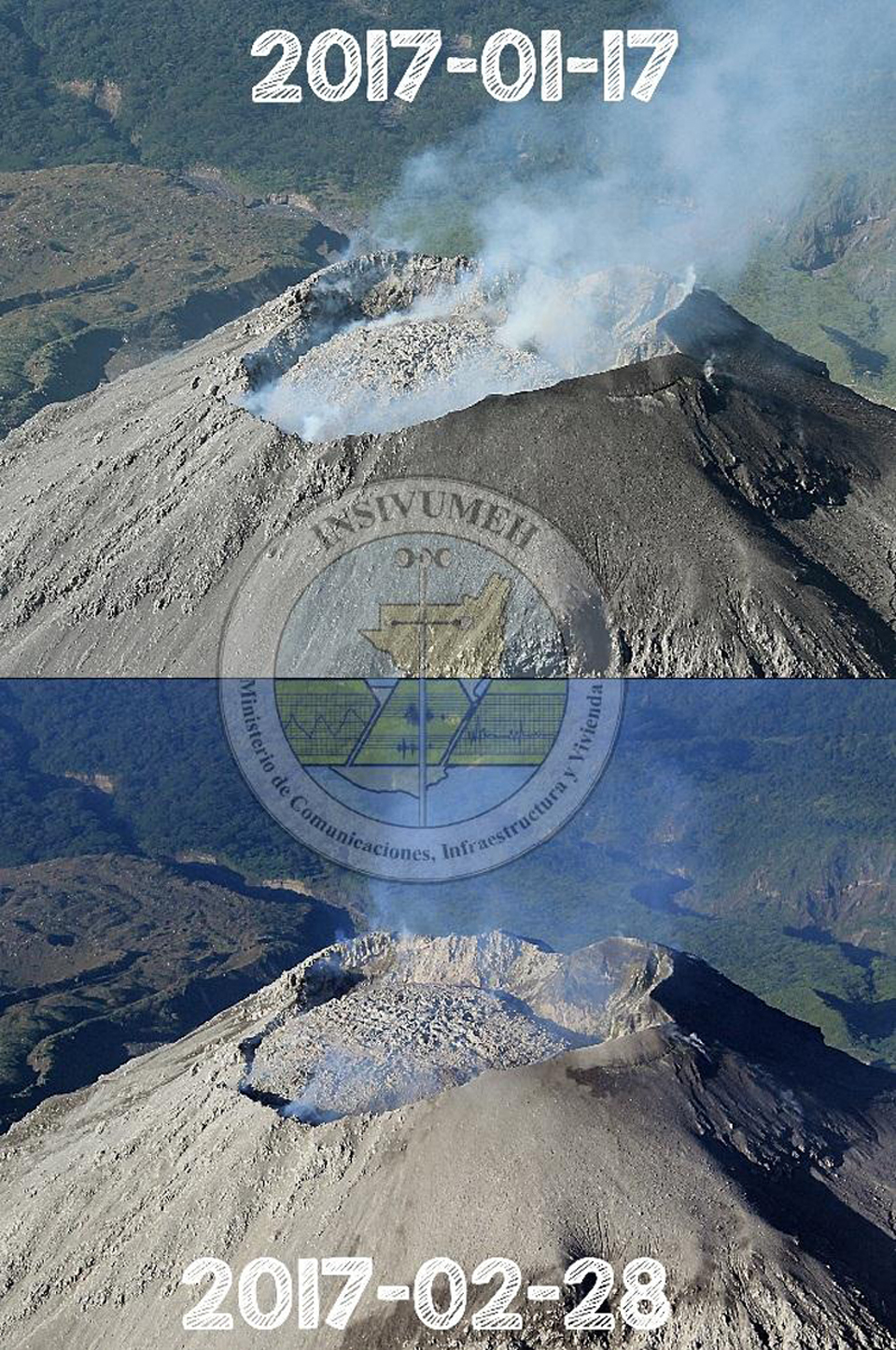 |
Figure 63. The lava dome inside the summit crater of Caliente grew noticeably between 17 January and 28 February 2017 at Santa María in this view to the S. Courtesy of INSIVUMEH (INFORME MENSUAL DE ACTIVIDAD VOLCÁNICA FEBRERO 2017). |
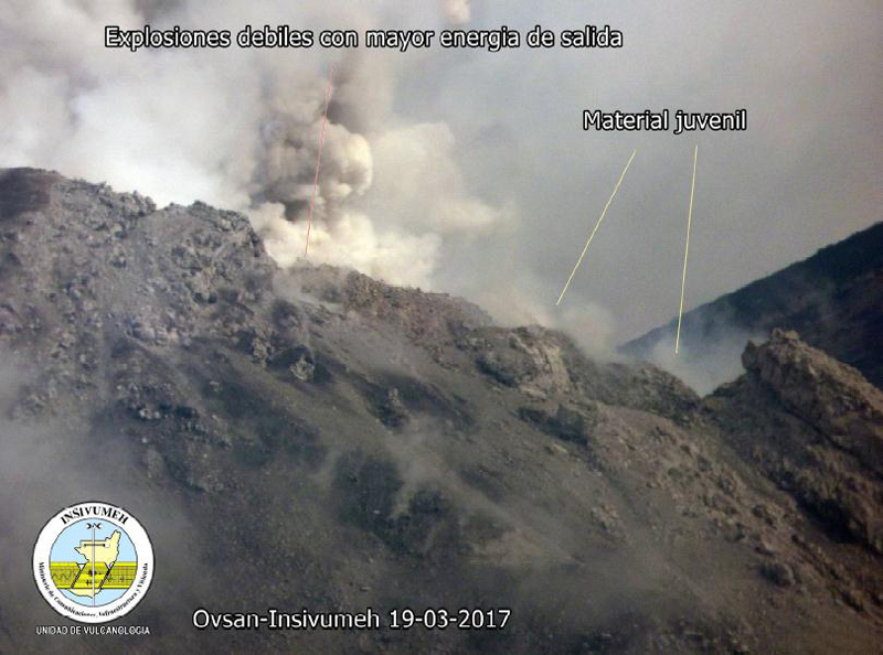 |
Figure 64. Ash and steam rises during an explosion from the new lava dome inside the summit crater of the Caliente dome of Santa María. Recently ejected blocks are steaming on the flanks close to the webcam on 19 March 2017. Courtesy of INSIVUMEH (INFORME MENSUAL DE ACTIVIDAD VOLCÁNICA MARZO 2017). |
By April 2017 the number of daily explosions had increased to 25-30, with similar energy levels and ash plume heights as earlier in the year. The Cabello de Ángel River continued downcutting through the 2014-2015 lava flows (figure 42, BGVN 41:09) creating a new channel that was 15-50 m deep (figure 65). During May, the number of daily explosions ranged from 9 to 26 (figure 66), and block avalanches from the new lava dome traveled short distances down the flanks. Two lahars were reported in May; on 6 May a lahar 30 m wide and 2.5 m deep descended the Cabello de Ángel drainage (a tributary of the Nimá I river on the S flank) carrying branches, tree trunks, and blocks up to 2 m in diameter. A smaller lahar on 31 May traveled down the Nimá I drainage and dragged smaller blocks and tree trunks down the channel.
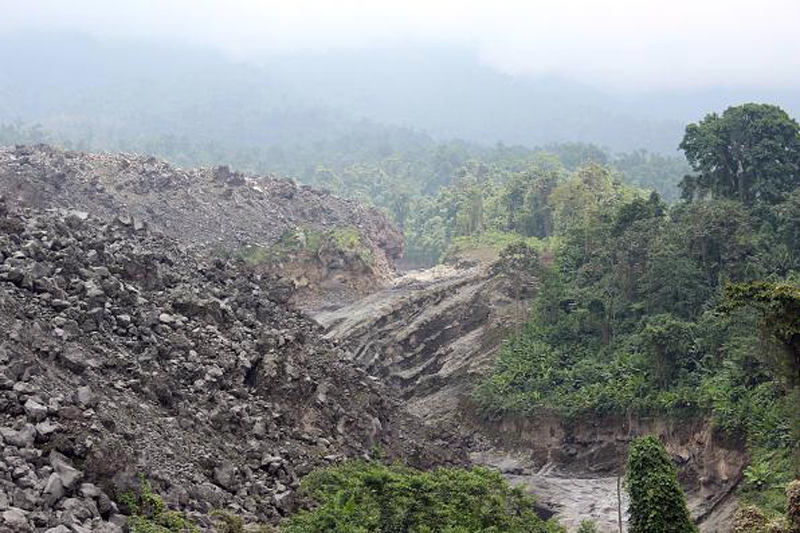 |
Figure 65. The Cabello de Ángel river cuts new channels through the 2014-2015 lava flows on the SE flank of Caliente dome at Santa María during April 2017. Courtesy of INSIVUMEH (INFORME MENSUAL DE ACTIVIDAD VOLCÁNICA ABRIL 2017). |
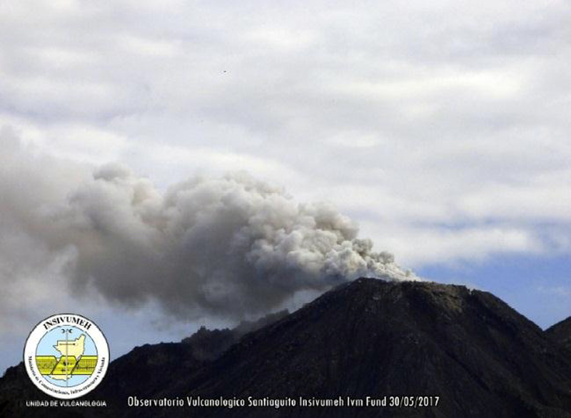 |
Figure 66. A moderate explosion on 30 May 2017 from Santiaguito at Santa María sends an ash plume to 2.6 km altitude that then drifted SW. Courtesy of INSIVUMEH (INFORME MENSUAL DE ACTIVIDAD VOLCÁNICA Mayo 2017). |
Explosions during June 2017 continued at the rate of 14-36 per day, with ash plumes rising to 2.7-3.3 km altitude (figure 67). Juvenile material continued to fill and overtop the crater rim, creating weak block avalanches down the flanks. Increased precipitation during June resulted in five lahars descending the Cabello de Ángel, Nimá I, and San Isidro drainages on 1, 5, 7, 9, and 16 June. They ranged in size from 15 to 25 m wide and 1 to 1.5 m high, and transported blocks 1-2 m in diameter. A larger lahar on 1 June that traveled down the Cabello de Ángel drainage was 30 m wide and 2 m high.
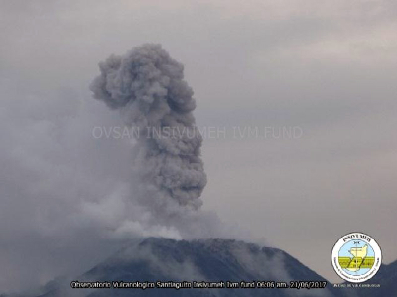 |
Figure 67. An ash plume at Santa María's Santiaguito complex on 21 June 2017 rises to 2.9 km. Courtesy of INSIVUMEH (INFORME MENSUAL DE ACTIVIDAD VOLCÁNICA Junio 2017). |
Similar explosive activity continued during July. On 5 July, a moderately-sized lahar descended the Cabello de Ángel drainage, a tributary of the Nimá I river. Near the El Faro estate, the lahar was 30 m wide and 1 m deep, and carried blocks 50 cm in diameter. On 14 July, another lahar traveled down the Nimá I drainage, which is a tributary of the Samalá. By August the summit crater of Caliente was nearly filled with the new lava dome, and overflows of block avalanches were more frequent, mostly traveling down the E flank (figure 68). A moderately-sized lahar descended the Nimá I drainage on 9 August.
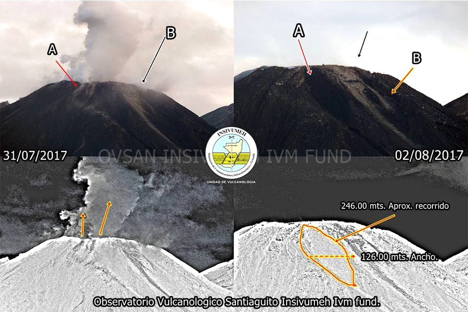 |
Figure 68. Fresh block avalanches were visible covering an area about 126 m wide and 246 m long near the summit of Caliente at Santa María when images from 31 July (left) and 2 August 2017 (right) were compared. Most of the block avalanches traveled down the east flank (A), but smaller avalanches traveled shorter distances down the NE flank (B). Courtesy of INSIVUMEH (Reporte Semanal de Monitoreo: Volcán Santiaguito (1402-03), Semana del 29 de julio al 04 de agosto de 2017). |
Explosions with ash plumes rising hundreds of meters above the crater rim continued daily during September and October, and sent block avalanches down the NE and SE flanks of the dome. INSIVUMEH reported that on 11 October 2017 a 12-m-wide and 1.5-m-high lahar descended the Cabello de Ángel and the Nimá I drainages, carrying blocks up to 1 m in diameter. On 13 October, the seismic network detected moderate-to-strong lahars in the Cabello de Ángel and the Nimá I drainages triggered by heavy rain.
Relatively few VAAC reports were issued for Santa María during 2017 compared with the previous two years. The Washington VAAC observed an ash plume in satellite imagery drifting 15 km W at 4.6 km altitude on 14 January. Morning visible imagery on 1 February showed an ash plume 25 km SW at 3.8 km altitude. An ash emission was observed on 27 February a few kilometers WSW at or slightly above the summit. Multiple small puffs of ash extended 55 km WSW of the summit on 9 March, at 4.6 km altitude. An ash plume was centered 15 km NW of the summit at 3.8 km altitude and rapidly dissipating on 4 April. The next VAAC observation, on 2 June, was a small puff of ash located 30 km S of the summit. On 6 September, possible volcanic ash was drifting SW of the summit at 4.3 km altitude.
Infrared MODIS satellite data suggest low-level, persistent activity at Santa María throughout January-October 2017 (figure 69). This is consistent with photographs of a slowly growing lava dome at the summit, and persistent low-energy explosions with ash emissions and block avalanches during the year. There were no MODVOLC thermal anomalies during this time.
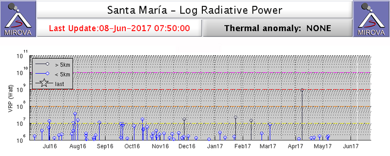 |
Figure 69. Infrared MODIS thermal data graphed through the MIROVA system indicates a low but persistent level of thermal activity at Santa María for the year ending on 8 June 2017. This is consistent with the observations of a slowly growing lava dome inside the summit crater. Courtesy of MIROVA. |
Geological Summary. Symmetrical, forest-covered Santa María volcano is part of a chain of large stratovolcanoes that rise above the Pacific coastal plain of Guatemala. The sharp-topped, conical profile is cut on the SW flank by a 1.5-km-wide crater. The oval-shaped crater extends from just below the summit to the lower flank, and was formed during a catastrophic eruption in 1902. The renowned Plinian eruption of 1902 that devastated much of SW Guatemala followed a long repose period after construction of the large basaltic andesite stratovolcano. The massive dacitic Santiaguito lava-dome complex has been growing at the base of the 1902 crater since 1922. Compound dome growth at Santiaguito has occurred episodically from four vents, with activity progressing E towards the most recent, Caliente. Dome growth has been accompanied by almost continuous minor explosions, with periodic lava extrusion, larger explosions, pyroclastic flows, and lahars.
Information Contacts: Instituto Nacional de Sismologia, Vulcanologia, Meteorologia e Hydrologia (INSIVUMEH), Unit of Volcanology, Geologic Department of Investigation and Services, 7a Av. 14-57, Zona 13, Guatemala City, Guatemala (URL: http://www.insivumeh.gob.gt/ ); Washington Volcanic Ash Advisory Center (VAAC), Satellite Analysis Branch (SAB), NOAA/NESDIS OSPO, NOAA Science Center Room 401, 5200 Auth Rd, Camp Springs, MD 20746, USA (URL: www.ospo.noaa.gov/Products/atmosphere/vaac, archive at: http://www.ssd.noaa.gov/VAAC/archive.html); MIROVA (Middle InfraRed Observation of Volcanic Activity), a collaborative project between the Universities of Turin and Florence (Italy) supported by the Centre for Volcanic Risk of the Italian Civil Protection Department (URL: http://www.mirovaweb.it/).