Report on Lopevi (Vanuatu) — January 2018

Bulletin of the Global Volcanism Network, vol. 43, no. 1 (January 2018)
Managing Editor: Edward Venzke.
Research and preparation by Paul Berger.
Lopevi (Vanuatu) Episodes of unrest in January and September 2017; gas-and-steam plumes
Please cite this report as:
Global Volcanism Program, 2018. Report on Lopevi (Vanuatu) (Venzke, E., ed.). Bulletin of the Global Volcanism Network, 43:1. Smithsonian Institution. https://doi.org/10.5479/si.GVP.BGVN201801-257050
Lopevi
Vanuatu
16.507°S, 168.346°E; summit elev. 1413 m
All times are local (unless otherwise noted)
Since an eruptive episode in May 2007, Loopevi has been quiet except for a thick gray plume on 24 February 2008 and a short-lived increase in activity in December 2014 (BGVN 32:05, 34:08, 40:05). This report covers activity during January 2015-December 2017. Data were primarily drawn from reports issued by the Vanuatu Geohazards Observatory (VGO) and the Wellington Volcanic Ash Advisory Center (VAAC).
Based on a pilot observation and webcam views, the Wellington VAAC reported that a short-lived steam-and-gas plume beginning at 0500 on 13 January 2017 produced a that rose no higher than 3 km in altitude and drifted SE. That same day VGO reported that the Volcanic Alert Level (VAL) was raised to 3 (on a scale of 0-5); it was lowered to Level 2 on 17 January and then to Level 1 on 20 February.
Steam plumes were again observed on 23 September by the web camera, prompting VGO to raise the VAL to 2, indicating major unrest (danger around the crater rim and specific area, considerable possibility of eruption, chance of flank eruption). Observation flights on 30 September and the first week of October showed that the activity was occurring only in the active craters below the summit crater (figure 24). Photographs and thermal infrared images taken during the flights confirmed that activity consisted of hot volcanic gas and steam. VGO reported that photos and satellite images acquired at the end of November confirmed that gas-and-steam emissions were continuing.
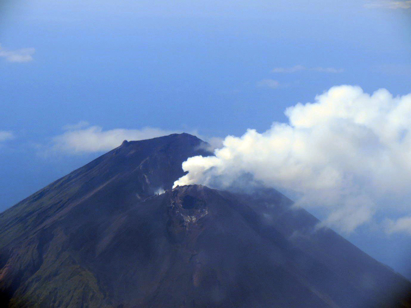 |
Figure 24.Aerial view of the active cone at Lopevi on 3 October 2017. Courtesy of VGO. |
The unrest continued through at least December 2017, and the VAL remained at 2. The Wellington VAAC noted that on 20 December a low-level plume was visible in satellite and webcam images drifting NW at an altitude of 1.5 km.
Geological Summary. The small 7-km-wide conical island of Lopevi, known locally as Vanei Vollohulu, is one of Vanuatu's most active volcanoes. A small summit crater containing a cinder cone is breached to the NW and tops an older cone that is rimmed by the remnant of a larger crater. The basaltic-to-andesitic volcano has been active during historical time at both summit and flank vents, primarily along a NW-SE-trending fissure that cuts across the island, producing moderate explosive eruptions and lava flows that reached the coast. Historical eruptions at the 1413-m-high volcano date back to the mid-19th century. The island was evacuated following major eruptions in 1939 and 1960. The latter eruption, from a NW-flank fissure vent, produced a pyroclastic flow that swept to the sea and a lava flow that formed a new peninsula on the western coast.
Information Contacts: Vanuatu Geohazards Observatory (VGO), Department of Geology, Mines and Water Resources of Vanuatu (URL: http://www.geohazards.gov.vu/, http://www.vmgd.gov.vu/vmgd/index.php/geohazards/volcano); Wellington Volcanic Ash Advisory Centre (VAAC), Meteorological Service of New Zealand Ltd (MetService), PO Box 722, Wellington, New Zealand (URL: http://www.metservice.com/vaac/, http://www.ssd.noaa.gov/VAAC/OTH/NZ/messages.html).