Report on Semeru (Indonesia) — January 2018

Bulletin of the Global Volcanism Network, vol. 43, no. 1 (January 2018)
Managing Editor: Edward Venzke.
Research and preparation by Paul Berger.
Semeru (Indonesia) Renewed thermal anomalies from mid-May through December 2017
Please cite this report as:
Global Volcanism Program, 2018. Report on Semeru (Indonesia) (Venzke, E., ed.). Bulletin of the Global Volcanism Network, 43:1. Smithsonian Institution. https://doi.org/10.5479/si.GVP.BGVN201801-263300
Semeru
Indonesia
8.108°S, 112.922°E; summit elev. 3657 m
All times are local (unless otherwise noted)
In 2016 and the first quarter of 2017, activity at Semeru was characterized by numerous ash explosions and thermal anomalies (BGVN 42:05). Thermal anomalies became consistent after mid-May 2017, increasing over the next few months and continuing through December 2017. The information below comes from the Pusat Vulkanologi dan Mitigasi Bencana Geologi (PVMBG, also known as the Center for Volcanology and Geological Hazard Mitigation, or CVGHM), the Darwin Volcanic Ash Advisor Center (VAAC), and MODIS thermal sensors aboard satellites. The Alert Level since February 2012 has remained at Yellow (Waspada, or Alert).
According to PVMBG monthly reports, Semeru did not show any change of activity during the reporting period. Presumably, this included numerous ash explosions and thermal anomalies indicating the presence of lava flows or dome growth. A Darwin VAAC ash advisory stated that an ash explosion on 7 June at 0020 UTC generated a plume that rose 4 km in altitude and drifted 13 km SW a day later.
Thermal anomalies, based on MODIS satellite instruments analyzed using the MODVOLC algorithm, were not observed between 19 November 2016 and 6 June 2017. On 6 June, a single hotspot was recorded, coincident with the ash explosion. The next hotspot occurred on 2 August, followed by anomalous pixels on three additional days through 13 August, but none during the rest of August. The number rose to 7-12 days per month during September-December, many of which were multi-pixel events.
The MIROVA (Middle InfraRed Observation of Volcanic Activity) system detected only two distinct MODIS hotspots during April through the middle of May 2017. After mid-May, the number rose dramatically and every month through December numerous hotspots were detected, almost all within 5 km of the volcano.
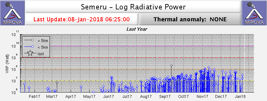 |
Figure 31. MODIS satellite thermal anomaly data at Semeru analyzed by the MIROVA system for the year ending 8 January 2018. Courtesy of MIROVA. |
Geological Summary. Semeru, the highest volcano on Java, and one of its most active, lies at the southern end of a volcanic massif extending north to the Tengger caldera. The steep-sided volcano, also referred to as Mahameru (Great Mountain), rises above coastal plains to the south. Gunung Semeru was constructed south of the overlapping Ajek-ajek and Jambangan calderas. A line of lake-filled maars was constructed along a N-S trend cutting through the summit, and cinder cones and lava domes occupy the eastern and NE flanks. Summit topography is complicated by the shifting of craters from NW to SE. Frequent 19th and 20th century eruptions were dominated by small-to-moderate explosions from the summit crater, with occasional lava flows and larger explosive eruptions accompanied by pyroclastic flows that have reached the lower flanks of the volcano.
Information Contacts: Pusat Vulkanologi dan Mitigasi Bencana Geologi (PVMBG, also known as Indonesian Center for Volcanology and Geological Hazard Mitigation, CVGHM), Jalan Diponegoro 57, Bandung 40122, Indonesia (URL: http://www.vsi.esdm.go.id/); Darwin Volcanic Ash Advisory Centre (VAAC), Bureau of Meteorology, Northern Territory Regional Office, PO Box 40050, Casuarina, NT 0811, Australia (URL: http://www.bom.gov.au/info/vaac/); MIROVA (Middle InfraRed Observation of Volcanic Activity), a collaborative project between the Universities of Turin and Florence (Italy) supported by the Centre for Volcanic Risk of the Italian Civil Protection Department (URL: http://www.mirovaweb.it/); Hawai'i Institute of Geophysics and Planetology (HIGP) - MODVOLC Thermal Alerts System, School of Ocean and Earth Science and Technology (SOEST), Univ. of Hawai'i, 2525 Correa Road, Honolulu, HI 96822, USA (URL: http://modis.higp.hawaii.edu/).