Report on Sinabung (Indonesia) — April 2018
Bulletin of the Global Volcanism Network, vol. 43, no. 4 (April 2018)
Managing Editor: Edward Venzke.
Edited by A. Elizabeth Crafford.
Sinabung (Indonesia) Large explosion with 16.8 km ash plume, 19 February 2018
Please cite this report as:
Global Volcanism Program, 2018. Report on Sinabung (Indonesia) (Crafford, A.E., and Venzke, E., eds.). Bulletin of the Global Volcanism Network, 43:4. Smithsonian Institution. https://doi.org/10.5479/si.GVP.BGVN201804-261080
Sinabung
Indonesia
3.17°N, 98.392°E; summit elev. 2460 m
All times are local (unless otherwise noted)
Indonesia's Sinabung volcano has been highly active since its first confirmed Holocene eruption during August and September 2010; ash plumes initially rose up to 2 km above the summit, and falling ash and tephra caused fatalities and thousands of evacuations (BGVN 35:07). It remained quiet after the initial eruption until 15 September 2013, when a new eruptive phase began that has continued uninterrupted through February 2018. Ash plumes rising several kilometers, avalanche blocks falling several kilometers down the flanks, and deadly pyroclastic flows travelling more than 4 km have all been documented repeatedly during the last several years. Details of events during October 2017-March 2018, including the largest explosion to date on 19 February 2018, are covered in this report. Information is provided by, Pusat Vulkanologi dan Mitigasi Bencana Geologi (PVMBG), referred to by some agencies as CVGHM or the Indonesian Center of Volcanology and Geological Hazard Mitigation, the Darwin Volcanic Ash Advisory Centre (VAAC), and the Badan Nacional Penanggulangan Bencana (National Disaster Management Authority, BNPB). Additional information comes from satellite instruments and local observers.
When activity began in 2010, and again when eruptions resumed in 2013, many news accounts included statements that Sinabung had last been active 400 years ago, or even saying specifically that the last eruption was in 1600 CE. Those claims appear to have been caused by a misunderstanding related to the boundary time that Indonesian volcanologists use to categorize volcanoes. Those volcanoes with historical activity, defined as being about 400 years ago (corresponding to the beginning of the Dutch East India Company era), are in the "Type A" group. Those in the "Type B" group, including Sinabung prior to 2010, have not had reported activity in more than 400 years. Using charcoal associated with the most recent pyroclastic flow, Hendrasto et al. (2012) determined that the last previous eruptive activity was 1200 years before present using carbon dating techniques, or 740-880 CE (at 1 sigma).
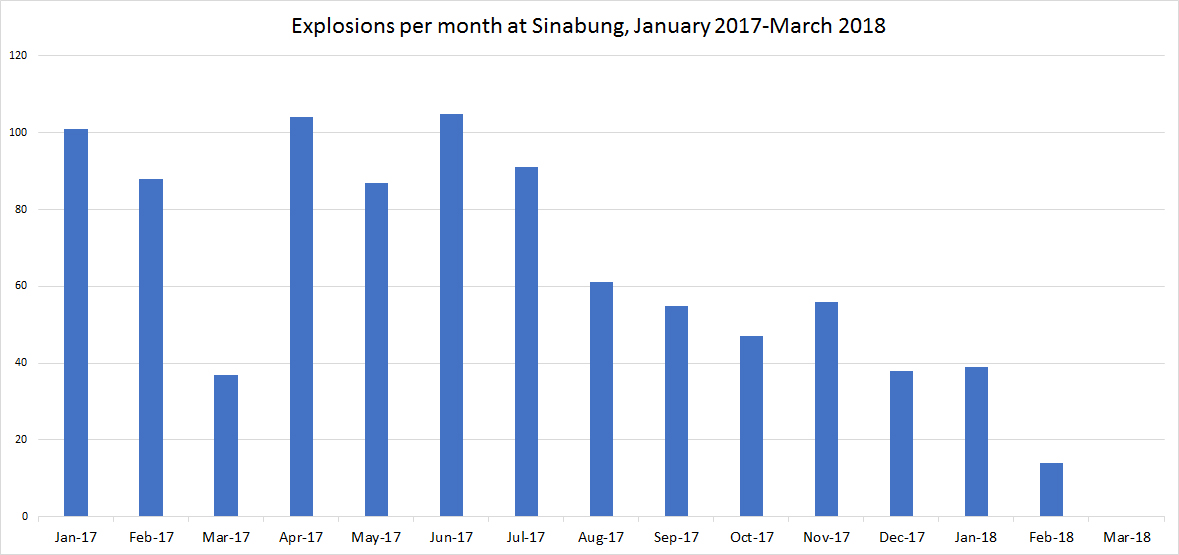
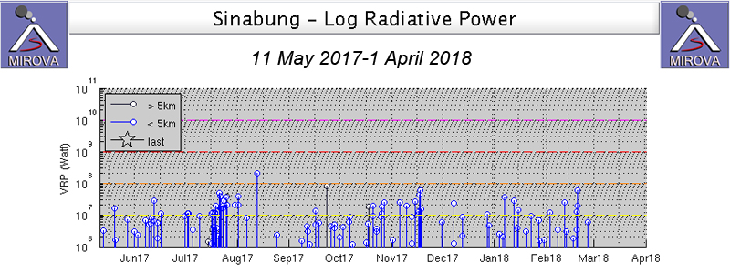
Although activity remained high from October 2017 through March 2018, a gradual decline in the overall eruptive activity from the beginning of 2017 was apparent. The number of explosions per month generally declined, with no explosions reported during March 2018, for the first time since August 2013 (figure 45). The thermal anomaly record was similar; periods of high heat flow persisted through mid-November 2017, followed by a gradual reduction in the amount of thermal activity, although the intensity remained consistent, according to the MIROVA project (figure 46). Much of the heat flow was attributed to the dome growth at the summit; the dome was destroyed in the large explosion of 19 February 2018.
Throughout the period from October 2017 through 19 February 2018, steam plumes were constantly rising to heights of 1,000-2,400 m above the summit. Avalanche blocks were ejected daily down the E and S flanks from 500-3,500 m, and multiple pyroclastic flows each month traveled between 1,000 and 4,600 m down the SE flank. Tens of explosions occurred monthly, generating ash plumes that rose from 500 to 5,000 m above the summit. Explosive activity was more intermittent during February than the previous months, until 19 February when the largest explosion to date occurred; it included an ash plume that rose to at least 16.8 km altitude and at least ten pyroclastic flows. In spite of the size of the explosion, no injuries or fatalities were reported as most nearby communities had been evacuated from the ongoing activity. Activity decreased substantially during March 2018; there were no explosions, block avalanches, or pyroclastic flows reported, only steam plumes rising 1,000 m above the summit.
Activity during October 2017-January 2018. During October 2017, steam plume heights reached 1,500 m above the summit. Avalanche blocks traveled down the E and S flanks 500-2,500 m, and eight pyroclastic flows traveled 1,000-4,500 m down the SE and S flanks. Ash plume heights ranged from 500 to 3,600 m above the summit. The Darwin VAAC issued 38 aviation alerts during the month. On 1 October they reported an ash plume drifting both NW at 4.6 km altitude and NE at 3.7 km. The next day, the webcam observed an ash emission that rose to 5.5 km altitude. On 4 October an ash plume was spotted in the webcam rising to 5.8 km altitude and drifting ENE. Later that day it had detached from the volcano and was seen drifting NW in satellite imagery. An ash plume on 5 October rose to 3.9 km altitude and drifted ESE. Two ash emission were reported on 7 October; the first rose to 3 km altitude, the second rose to 4.3 km, they both dissipated quickly. On 8 October, three plumes were reported. The first rose to 4.6 km and drifted WSW, the second rose to 3 km and drifted S and the third rose to 3.4 km and also drifted S. The following day, an ash plume rose to 4.6 km and drifted E. BNPB stated that on 11 October, an event at Sinabung generated an ash plume that rose 1.5 km above the crater and drifted ESE, causing ashfall in several local villages. On 12 October an event produced an ash plume that rose 2 km above the crater and was followed by pyroclastic flows traveling 1.5 and 2 km down the S and ESE flanks, respectively.
PVMBG reported ash plumes rising to 3.7 km on 11, 12, and 13 October 2017. Later on 13 October the Jakarta MWO reported an ash plume at 4.3 km. The next day PVMBG reported an ash plume at 5.5 km altitude. A plume on 15 October rose to 3 km and drifted E. A steam plume on 16 October drifted down the SE flank before drifting SE no 16 October (figure 47). On 17 October, a discrete emission rose a few hundred meters above the summit drifted NE. Later that day, an ash plume was seen in the webcam moving SE at 3.4 km. On 18 October, two ash emissions were reported. The first rose to 3.7 km and drifted E, the second rose to 3.9 km and drifted W. An ash plume rose to 4.6 km altitude on 21 October, and to 3.9 km, drifting S, on 23 October. The next day, three ash plumes were reported; the first rose to 3 km, the second to 4.6 km, and the third to 3.7, all drifting E. After five days of quiet, the webcam observed ash plumes that rose to 4.3 km on 30 October, and to 3.9 km on 31 October. Only two MODVOLC thermal alerts were issued, on 20 and 27 October.
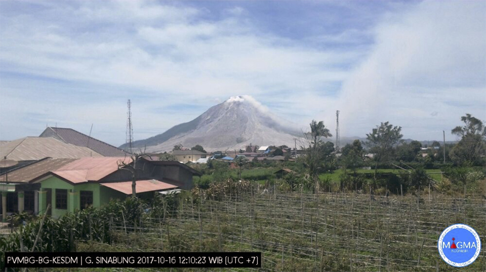 |
Figure 47. A steam plume drifted down the SW flank of Sinabung before moving SE on 16 October 2017. View is from the SE. Courtesy of PVMBG. |
Steam plumes were higher during November 2017, rising 2,400 m above the summit. Block avalanches traveled 500-3,000 m down the E and S flanks most days, and ten pyroclastic flows traveled between 2,000-3,500 m down the ESE and S flanks. The ash plumes rose 700-3,200 m above the summit. The Darwin VAAC issued 41 aviation alerts in November. Near-daily ash plumes were observed mostly in the webcam and occasionally in satellite imagery. They generally rose to 3.4-4.9 km altitude; the most common drift directions were S and SW. A number of times, multiple ash plumes were reported in a single day. On 14 November, four ash plumes were observed. The first rose to 3.7 km, the second and third rose to 4.6 km and drifted S and SSW, the last rose to 3.9 km and also drifted SSW. On 20 November a discrete emission produced an ash plume that rose to 5.5 km altitude and drifted SSW. Three ash plumes were recorded the next day, rising 3.9-4.6 km and drifting in multiple directions under variable winds. An ash plume on 23 November was reported by PVMBG at 6.7 km altitude drifting W, the highest noted for the month. MODVOLC thermal alerts appeared twice on 5 November, once on 14 November, and three times on 17 November.
Activity during December 2017 was similar to the previous two months; steam plumes rose 2,000 m above the summit, block avalanches traveled 500-3,500 m down the E and S flanks numerous times, and nine pyroclastic flows descended the ESE and S flanks distances ranging from 2,000 to 4,600 m. Ash plume heights were from 700-4,000 m above the summit. The Darwin VAAC issued 43 aviation alerts in December 2017. They reported ash plume heights of 3.4-4.9 km altitude on most days. Every day during 10-19 December, ash plumes were reported at altitudes of 4.6-5.5 km drifting SW, E or SE. PVMBG reported ash plumes on 26, 27 and 28 December that rose to 3.9, 5.2, and 5.5 km, respectively. BNPB reported pyroclastic flows on 27 December that traveled 3.5-4.6 km SE, and ashfall was reported in many nearby villages including Sukanalu Village (20 km SE), Tonggal Town, Central Kuta, Gamber (4 km SE), Berastepu (4 km SE), and Jeraya (6 km SE). The highest ash plume of the month rose to 6.4 km altitude on 29 December and drifted E. This was followed by another discrete ash emission the same day that rose to 5.8 km and two plumes the next day that rose to 5.2 km and drifted W. There was only one MODVOLC thermal alert issued on 7 December.
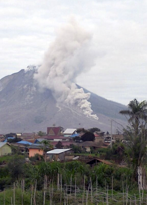
The Darwin VAAC issued 56 aviation alerts for January 2018. Multiple discrete ash emissions were reported on most days. Plume altitudes generally ranged from 3.4 to 5.5 km. A 6.1 km altitude plume was visible in satellite imagery on 18 January (figure 48). The drift directions were highly variable throughout the month. Most plumes dissipated within six hours. Incandescent blocks were reported by PVMBG falling 500-1,500 m down the ESE flank on most days when the summit was visible. They also reported a pyroclastic flow on 27 January that traveled 2,500 m ESE from the summit (figure 49). Three MODVOLC thermal alerts were issued on 6 January, and one on 12 January.
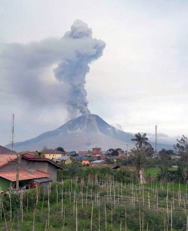 |
Figure 48. An ash plume rose 3,000 m from the summit of Sinabung on 18 January 2018 in this view looking at the SE flank. Photographer unknown, courtesy of Sutopo Purwo Nugroho, Twitter. |
Activity during February 2018. During most of February, steam plumes rose only 1,000 m above the summit, and avalanche blocks traveled 500-2,500 m down the ESE and S flanks. Far fewer ash emissions were reported than previous months, but the largest explosive event recorded to date took place on 19 February (figure 50). The Darwin VAAC issued 29 aviation alerts during February 2018. Short-lived ash emissions were reported on 1, 3, 5, 11, and 15 February. The ash plume heights ranged from 3.4-4.6 km altitude, and they drifted S or SW.
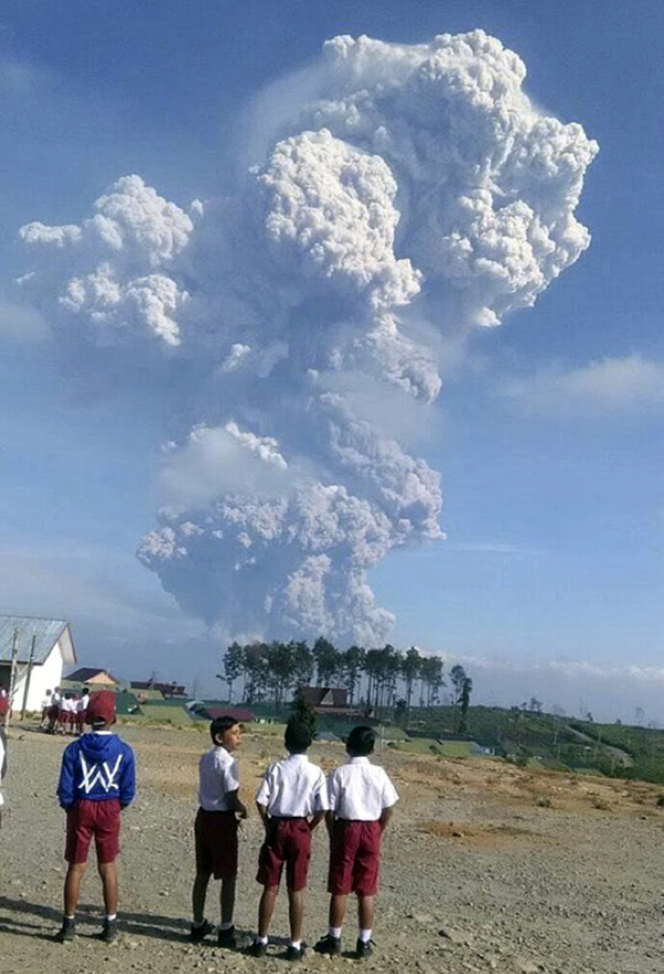
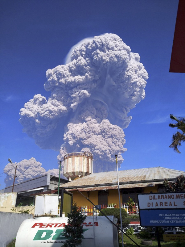
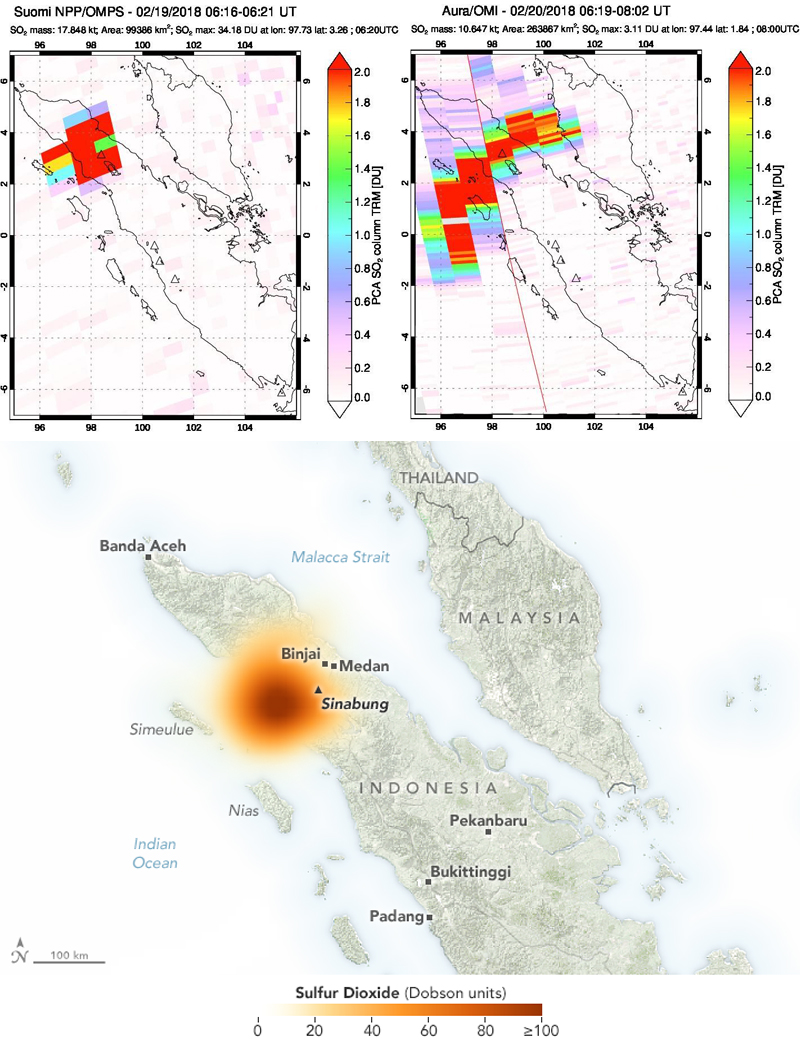
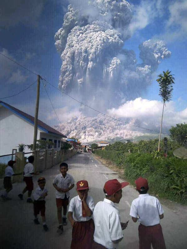
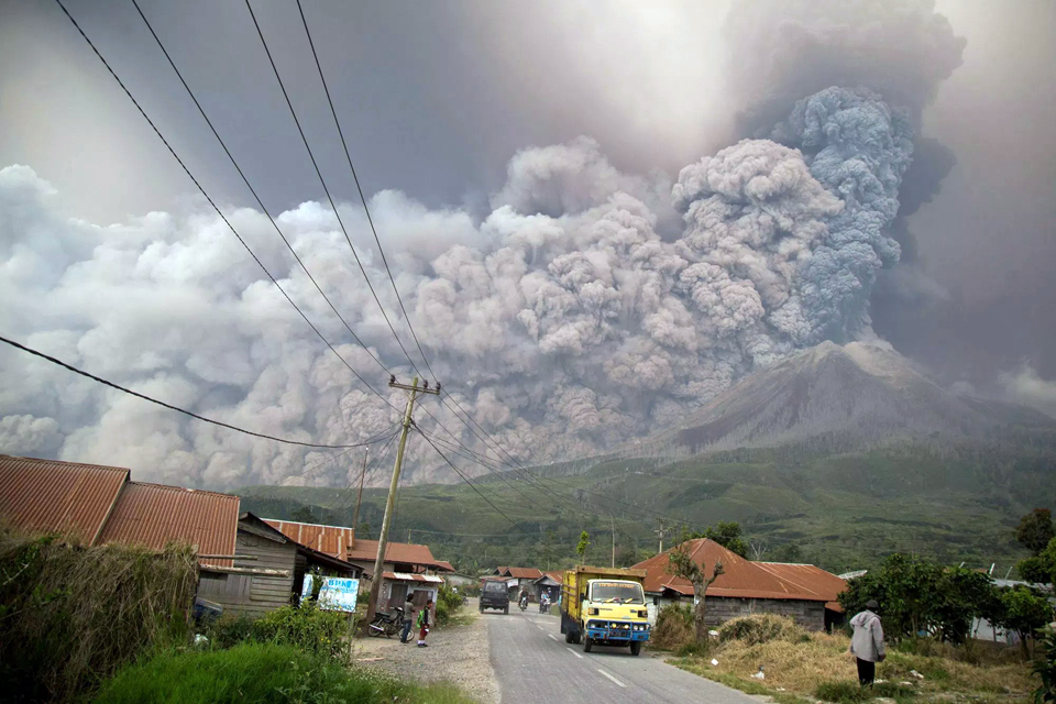
The large explosion was first reported by the Darwin VAAC at 0255 UTC on 19 February 2018. It produced an ash plume, which was clearly observed in satellite imagery (figure 51), that quickly rose to at least 16.8 km altitude and began drifting NW (figure 52). It also produced a large SO2 plume that was recorded by satellite instruments (figure 53). Over the next 15 hours the plume dispersed in three different directions at different altitudes. The highest part of the plume drifted NW at 13.7 km and was visible over 300 km from the summit. The lower part of the plume drifted S initially at 6.7 km and gradually lowered to 4.3 km; it was visible 75 km from the summit before dissipating. A middle part of the plume drifted NW at 9.1 km during the middle of the day. Three subsequent minor ash emissions were observed on 20 and 25 February that rose to 3.4 km altitude. There were no VAAC reports issued during March 2018. A MODVOLC thermal alert issued on 11 February was the last for several months.
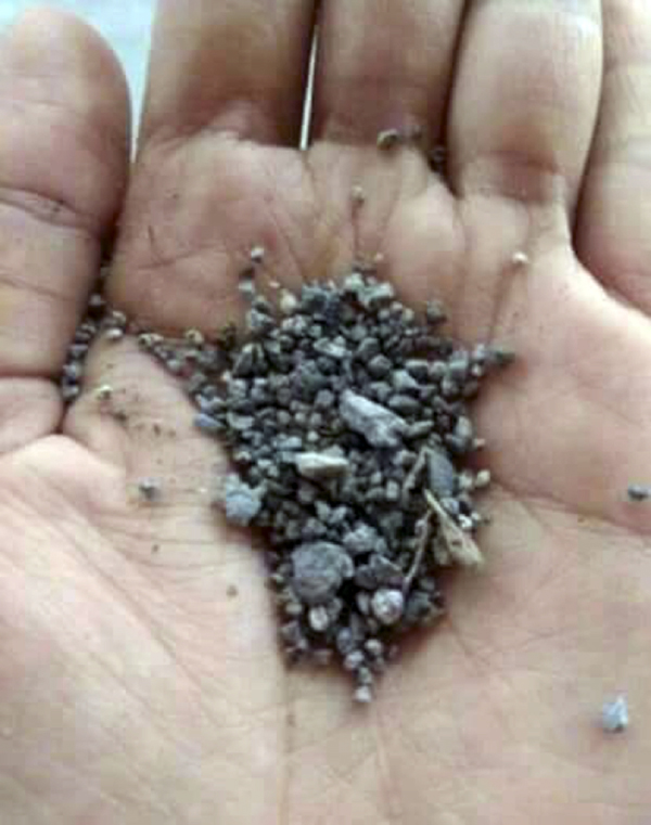
As many as 10 pyroclastic flows were observed during the 19 February explosion, traveling as far as 4.9 km SSE and 3.5 km E (figures 54 and 55). Ash and tephra as large as a few millimeters in diameter fell in areas downwind, including Simpang Empat (7 km SE), the Namanteran district, Pqyung (5 km SSW), Tiganderket (7 km W), Munthe, Kutambaru (20 km NW), Perbaji (4 km SW), and Kutarayat (figure 56 and 57).
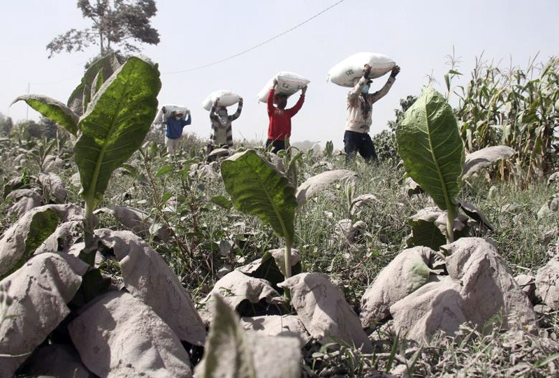 |
Figure 57. Ash from the eruption at Sinabung on 19 February 2018 covered vegetable plants the following day in the village of Payung (5 km SSW). Photograph by Antara Foto, Ahmad Putra via Reuters. |
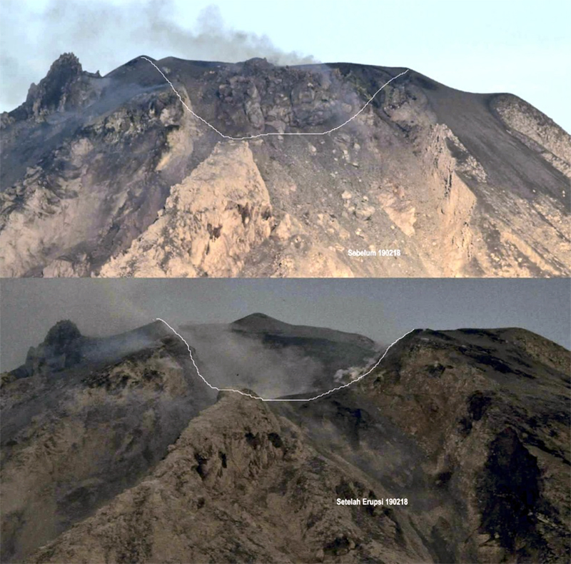
Villagers were temporarily evacuated from nearby villages, but were able to return a few days later (figure 58). Conditions in five districts were so dark that visibility was reduced to about 5 m. In addition, ashfall was recorded as far away as the town of Lhokseumawe, 260 km N. Magma Indonesia reported that the lava dome that had been growing at the summit for some time was destroyed in the 19 February explosion (figure 59). A PVMBG volcanologist reported the volume of the destroyed lava dome was at least 1.6 million cubic meters.
Reference: Hendrasto M, Surono, Budianto A, Kristianto, Triastuty H, Haerani N, Basuki A, Suparman Y, Primulyana S, Prambada O, Loeqman A, Indrastuti N, Andreas A S, Rosadi U, Adi S, Iguchi M, Ohkura T, Nakada S, Yoshimoto M, 2012. Evaluation of Volcanic Activity at Sinabung Volcano, After More Than 400 Years of Quiet. Journal of Disaster Research, vol. 7, no. 1, p. 37-44.
Geological Summary. Gunung Sinabung is a Pleistocene-to-Holocene stratovolcano with many lava flows on its flanks. The migration of summit vents along a N-S line gives the summit crater complex an elongated form. The youngest crater of this conical andesitic-to-dacitic edifice is at the southern end of the four overlapping summit craters. The youngest deposit is a SE-flank pyroclastic flow 14C dated by Hendrasto et al. (2012) at 740-880 CE. An unconfirmed eruption was noted in 1881, and solfataric activity was seen at the summit and upper flanks in 1912. No confirmed historical eruptions were recorded prior to explosive eruptions during August-September 2010 that produced ash plumes to 5 km above the summit.
Information Contacts: Pusat Vulkanologi dan Mitigasi Bencana Geologi (PVMBG, also known as Indonesian Center for Volcanology and Geological Hazard Mitigation, CVGHM), Jalan Diponegoro 57, Bandung 40122, Indonesia (URL: http://www.vsi.esdm.go.id/); Badan Nasional Penanggulangan Bencana (BNPB), National Disaster Management Agency, Graha BNPB - Jl. Scout Kav.38, East Jakarta 13120, Indonesia (URL: http://www.bnpb.go.id/); Sutopo Purwo Nugroho, Head of Information Data and Public Relations Center of BNPB via Twitter (URL: https://twitter.com/Sutopo_PN); MAGMA Indonesia, Kementerian Energi dan Sumber Daya Mineral (URL: https://magma.vsi.esdm.go.id/); Hawai'i Institute of Geophysics and Planetology (HIGP) - MODVOLC Thermal Alerts System, School of Ocean and Earth Science and Technology (SOEST), Univ. of Hawai'i, 2525 Correa Road, Honolulu, HI 96822, USA (URL: http://modis.higp.hawaii.edu/); MIROVA (Middle InfraRed Observation of Volcanic Activity), a collaborative project between the Universities of Turin and Florence (Italy) supported by the Centre for Volcanic Risk of the Italian Civil Protection Department (URL: http://www.mirovaweb.it/); NASA Earth Observatory, EOS Project Science Office, NASA Goddard Space Flight Center, Goddard, Maryland, USA (URL: http://earthobservatory.nasa.gov/); NASA Goddard Space Flight Center (NASA/GSFC), Global Sulfur Dioxide Monitoring Page, Atmospheric Chemistry and Dynamics Laboratory, 8800 Greenbelt Road, Goddard, Maryland, USA (URL: https://so2.gsfc.nasa.gov/); Associated Press (AP), Endro Rusharyanto, Photographer (URL: http://www.ap.org/); Reuters (http://www.reuters.com/).

