Report on Santa Maria (Guatemala) — May 2018

Bulletin of the Global Volcanism Network, vol. 43, no. 5 (May 2018)
Managing Editor: Edward Venzke.
Edited by A. Elizabeth Crafford.
Santa Maria (Guatemala) Daily explosions with minor ash and block avalanches at Caliente, November 2017-April 2018
Please cite this report as:
Global Volcanism Program, 2018. Report on Santa Maria (Guatemala) (Crafford, A.E., and Venzke, E., eds.). Bulletin of the Global Volcanism Network, 43:5. Smithsonian Institution. https://doi.org/10.5479/si.GVP.BGVN201805-342030
Santa Maria
Guatemala
14.757°N, 91.552°W; summit elev. 3745 m
All times are local (unless otherwise noted)
The dacitic Santiaguito lava-dome complex on the W flank of Guatemala's Santa María volcano has been growing since 1922. The youngest of the four vents in the complex, Caliente, has been actively erupting with ash explosions, pyroclastic, and lava flows for more than 40 years. During January-October 2017 (BGVN 42:12), daily weak ash emissions sent ash plumes to altitudes around 3.3 km, and ashfall was frequent in villages and farms within 12 km S and SW. The lava dome that appeared within the summit crater of Caliente in October 2016 continued to grow, increasing the frequency of block avalanches moving down the flanks. Several lahars affected the major drainages during May-October. Guatemala's INSIVUMEH (Instituto Nacional de Sismologia, Vulcanologia, Meterologia e Hidrologia) and the Washington VAAC (Volcanic Ash Advisory Center) provided regular updates on the continuing activity during the time period of this report from November 2017-April 2018.
Activity at Santa Maria was very consistent with little variation during November 2017-April 2018. Plumes of steam with minor magmatic gases rose continuously from the Caliente crater 300-500 m above the summit, drifting SW or SE before dissipating. In addition, tens of daily explosions with varying amounts of ash rose to altitudes of around 3.5-4.0 km and usually traveled short distances of 20-30 km before dissipating. The longest-lived plume, on 22 March 2018 drifted 100 km before dispersing. Almost all of the plumes drifted SW or SE; minor ashfall occurred in the mountains and was reported at the fincas up to 15 km away in those directions several times each month. Continued growth of the lava dome at Caliente resulted in block avalanches descending its flanks every day. The MIROVA plot of thermal energy during this time shows a consistent level of heat flow with minor variations. The spike of strongest heat flow in late March 2018 corresponds with the largest ash plume reported (figure 70) for the period.
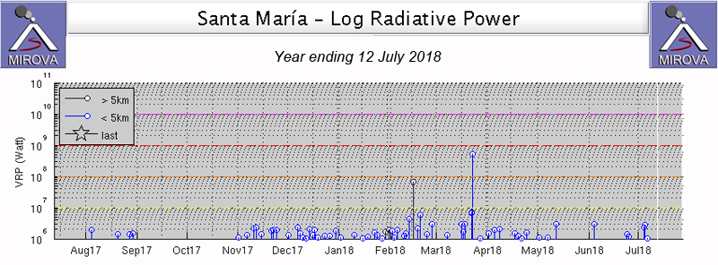 |
Figure 70. MIROVA plot of thermal energy from Santa Maria for the year ending 12 July 2018 shows persistent low levels of heat flow. The spike at the end of March 2018 corresponds to the largest reported ash plume for the period. Courtesy of MIROVA. |
Activity during November 2017-January 2018. During November 2017, persistent steam plumes rose 100-500 m above the summit crater at Caliente, and generally drifted SE. Tens of weak explosions daily created ash plumes that rose to about 3.2 km altitude and drifted usually SE. These resulted in ashfall reported near Finca San José on 9, 26, and 28 November, and in the mountains around Finca la Florida on 27 November. The Washington VAAC reported an ash emission seen in satellite imagery on 18 November drifting S about 15 km from the summit at 4.3 km altitude. Block avalanches were reported daily, they usually extended down the SE flank, occasionally making it to the base of the dome.
Characteristic steam plumes rising 100-500 m continued daily throughout December 2017. Numerous daily weak to moderate explosions generated ash plumes that rose to around 3.0-3.3 km altitude and drifted most often to the SW. Weak to moderate, and occasionally strong block avalanches descended the SE flank of the dome most days.
The Caliente dome maintained constant degassing with mostly steam plumes and occasional magmatic gas throughout January 2018 (figure 71). The plumes rose 50-300 m above the dome; most plumes came from the crater, but a few rose from fissures on the flanks. Explosions with ash plumes rose to 2.8-3.5 km altitude and generally drifted W or SW (figure 72). The seismic station registered 15-21 weak to moderate explosions per day. Ash generally drifted to the E or SE and caused ashfall in the regions around the fincas of San José, Patzulin, La Quina and others. Finca San José reported ashfall in the vicinity on 6, 7, and 9 January, and El Faro noted nearby ashfall on 9 January. A small plume with minor ash content was noted in satellite imagery by the Washington VAAC on 10 January drifting E at 4.3 km altitude. Ash emissions extended about 35 km SW before dissipating on 12 January, also at 4.3 km. Weak and moderate-size block avalanches occurred daily with blocks generally descending the SE or E flank of the dome.
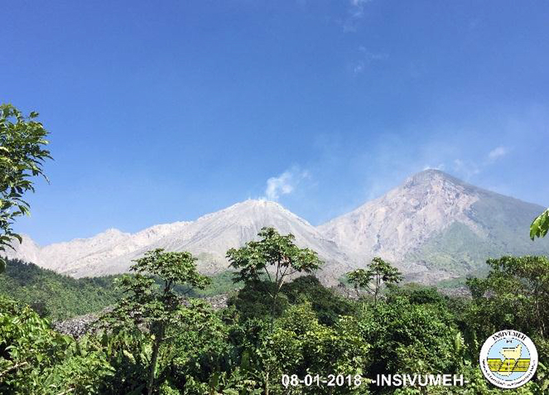 |
Figure 71. A typical plume of steam and magmatic gas rose from the Caliente vent at Santa Maria on 8 January 2018. Courtesy of INSIVUMEH (Informe mensual de actividad volcánica enero 2018, Volcán Santiaguito, 1402-03). |
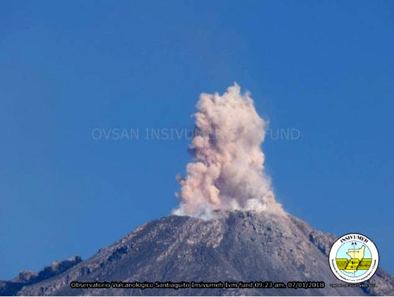 |
Figure 72. An explosion at the Caliente dome of Santa Maria on 7 January 2018 sent ash a few hundred meters above the summit crater. Courtesy of INSIVUMEH (Informe mensual de actividad volcánica enero 2018, Volcán Santiaguito, 1402-03). |
Activity during February-April 2018. Plumes of steam and gas continued rising daily to a few hundred meters above Caliente during February 2018. Weak and moderate explosions with steam and ash rose to 2.6-3.2 km altitude and drifted variably S, SE, W, or SW during the month (figure 73). Explosions averaged about 14 per day. Ashfall was reported in the fincas to the E and SE during the first week, including at Finca San José on 5 February, and la Florida on 10 February; they occurred in the mountainous areas W and SW during the rest of the month. Ashfall was also reported around the perimeter of the volcano several times during the last week of the month. The Washington VAAC reported an ash plume at 4.6 km altitude on 12 February drifting rapidly W, and a thin veil of gas and minor ash on 28 February extending about 15 km SW from the summit at 4.3 km altitude. Observations of repeated block avalanches down the SE flank throughout the month concurred with thermal measurements on 28 February that showed the hottest areas of the dome at the summit and on the SE flank (figure 74).
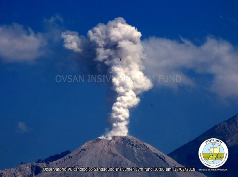 |
Figure 73. An explosion of steam and ash rose from Caliente at Santa Maria on 18 February 2018. Courtesy of INSIVUMEH (Reporte Semanal de Monitoreo: Volcán Santiaguito (1402-03), Semana del 17 al 23 de febrero de 2018). |
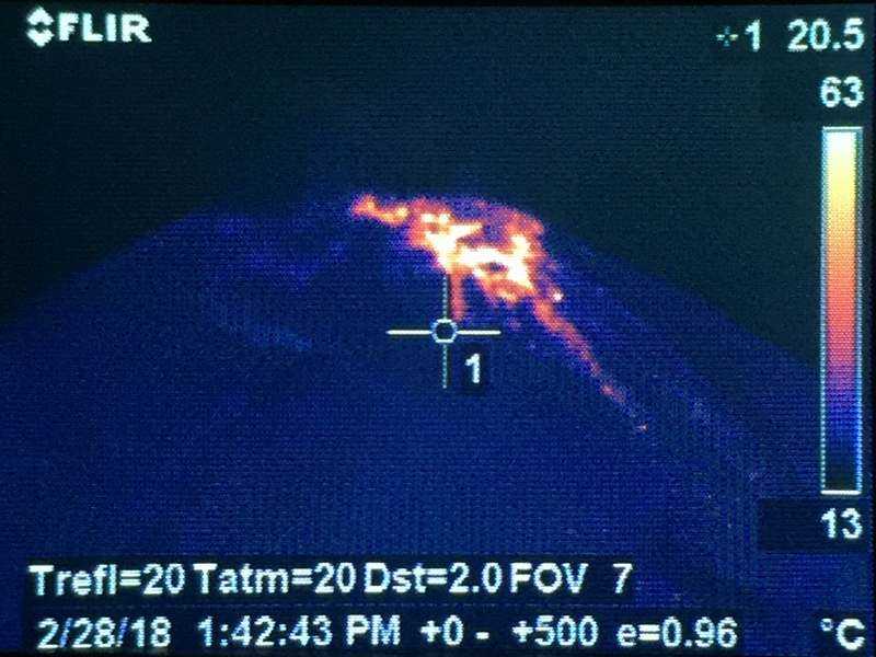 |
Figure 74. Material inside the summit crater of Caliente at Santa Maria measured about 140°C on 28 February 2018, and showed the warmest region on the SE flank where most of the block avalanches occurred. Courtesy of INSIVUMEH (Reporte Semanal de Monitoreo:, Volcán Santiaguito (1402-03), Semana del 24 de febrero al 02 de marzo de 2018). |
Block avalanches down the SE and S flanks of Caliente from the growing summit dome persisted at weak to moderate levels throughout March 2018 (figure 75). Ten to twenty daily ash-bearing explosions usually rose to about 3.2 km altitude and drifted SW or SE causing ashfall around the perimeter. Ashfall was reported in the mountains around Finca San José on 4-6, 9, 20, and 23 March, and in the Palajunoj area on 11 March. Steam plumes rising from the summit of Caliente to 2.9-3.1 km altitude drifting SE or SW were a daily feature of activity (figure 76). The Washington VAAC reported an ash plume on 5 March that rose to 4.6 km altitude and drifted SW before dissipating within 15 km of the summit. On 21 March, an emission was observed in satellite imagery that extended about 35 km SW from the summit at 4.6 km altitude. Another ash plume the following day also rose to 4.6 km altitude and extended almost 100 km SW before dissipating. That same day, 22 March, MODVOLC issued four thermal alerts for Santiaguito, and the MIROVA system showed a spike in thermal activity as well (figure 70).
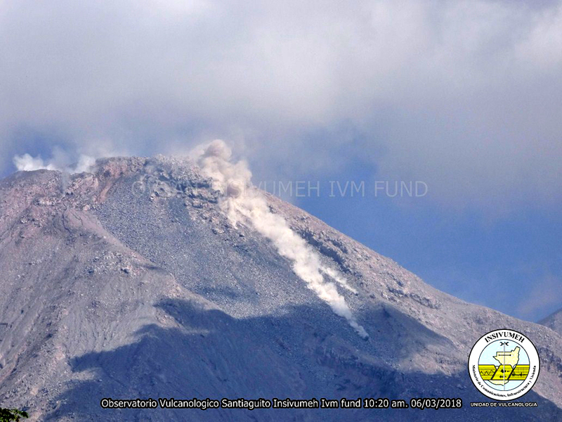 |
Figure 75. Block avalanches descended the SE flank of Caliente at Santa Maria on 6 March 2018. Courtesy of INSIVUMEH (Reporte Semanal de Monitoreo:, Volcán Santiaguito (1402-03), Semana del 03 al 09 de marzo de 2018). |
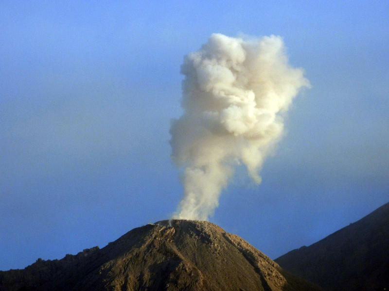 |
Figure 76. A typical steam plume rose from Caliente summit during the last week of March 2018. Courtesy of INSIVUMEH (Reporte Semanal de Monitoreo: Volcán Santiaguito (1402-03), Semana del 17 al 23 de marzo de 2018). |
Multiple daily explosions with ash rose up to 3.2 km altitude during April 2018. The plumes drifted SW or SE, spreading fine-grained ash over the nearby hills. Finca San José reported ashfall on 2 April and the Palajunoj area reported ashfall on 10, 13, 15, and 17 April. Abundant degassing of mostly steam plumes at the Caliente crater continued throughout the month, as did the constant descent of block avalanches down the SE flank.
Geological Summary. Symmetrical, forest-covered Santa María volcano is part of a chain of large stratovolcanoes that rise above the Pacific coastal plain of Guatemala. The sharp-topped, conical profile is cut on the SW flank by a 1.5-km-wide crater. The oval-shaped crater extends from just below the summit to the lower flank, and was formed during a catastrophic eruption in 1902. The renowned Plinian eruption of 1902 that devastated much of SW Guatemala followed a long repose period after construction of the large basaltic andesite stratovolcano. The massive dacitic Santiaguito lava-dome complex has been growing at the base of the 1902 crater since 1922. Compound dome growth at Santiaguito has occurred episodically from four vents, with activity progressing E towards the most recent, Caliente. Dome growth has been accompanied by almost continuous minor explosions, with periodic lava extrusion, larger explosions, pyroclastic flows, and lahars.
Information Contacts: Instituto Nacional de Sismologia, Vulcanologia, Meteorologia e Hydrologia (INSIVUMEH), Unit of Volcanology, Geologic Department of Investigation and Services, 7a Av. 14-57, Zona 13, Guatemala City, Guatemala (URL: http://www.insivumeh.gob.gt/ ); MIROVA (Middle InfraRed Observation of Volcanic Activity), a collaborative project between the Universities of Turin and Florence (Italy) supported by the Centre for Volcanic Risk of the Italian Civil Protection Department (URL: http://www.mirovaweb.it/); Hawai'i Institute of Geophysics and Planetology (HIGP) - MODVOLC Thermal Alerts System, School of Ocean and Earth Science and Technology (SOEST), Univ. of Hawai'i, 2525 Correa Road, Honolulu, HI 96822, USA (URL: http://modis.higp.hawaii.edu/); Washington Volcanic Ash Advisory Center (VAAC), Satellite Analysis Branch (SAB), NOAA/NESDIS OSPO, NOAA Science Center Room 401, 5200 Auth Rd, Camp Springs, MD 20746, USA (URL: www.ospo.noaa.gov/Products/atmosphere/vaac, archive at: http://www.ssd.noaa.gov/VAAC/archive.html).