Report on Nyiragongo (DR Congo) — June 2018

Bulletin of the Global Volcanism Network, vol. 43, no. 6 (June 2018)
Managing Editor: Edward Venzke.
Research and preparation by Robert Andrews.
Nyiragongo (DR Congo) Thermal anomalies show that lava lake remains active through May 2018
Please cite this report as:
Global Volcanism Program, 2018. Report on Nyiragongo (DR Congo) (Venzke, E., ed.). Bulletin of the Global Volcanism Network, 43:6. Smithsonian Institution. https://doi.org/10.5479/si.GVP.BGVN201806-223030
Nyiragongo
DR Congo
1.52°S, 29.25°E; summit elev. 3470 m
All times are local (unless otherwise noted)
As has been the case since at least 1971, the active lava lake in the summit crater of Nyiragongo was present during a tourist visit in June 2017, and seismicity was recorded in the crater in October 2017 (BGVN 42:11). Thermal data from satellite-based instruments shows that an open lava lake remained through 23 May 2018. MIROVA analysis of MODIS satellite thermal data (figure 64) shows nearly daily strong thermal anomalies. Similarly, MODVOLC alerts for the same time period shows a consistently frequent number of anomalies (figure 65).
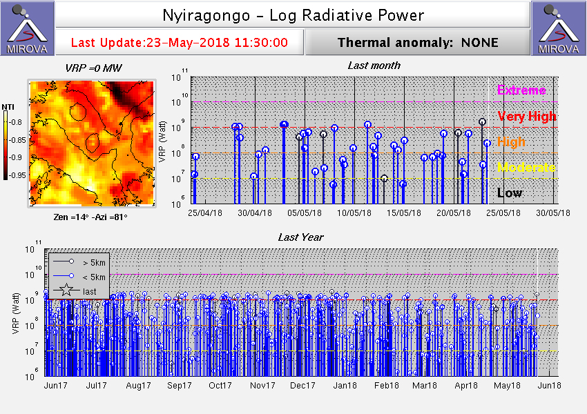 |
Figure 64. Thermal anomaly MIROVA plot of log radiative power at Nyiragongo for the year ending 23 May 2018. Courtesy of MIROVA. |
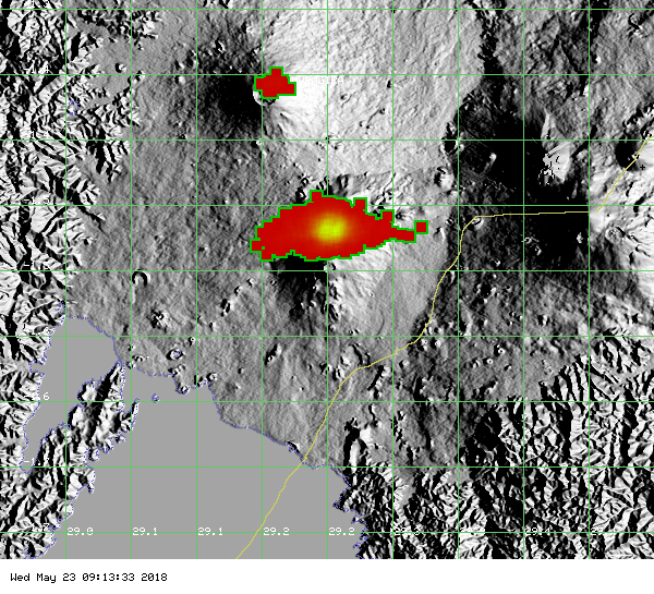 |
Figure 65. Map showing MODVOLC alert pixels at Nyiragongo, reflecting MODIS satellite thermal data, for the year ending 23 May 2018. Each pixel shows a thermal alert for a ground area of about 1.5 km2. Nyiragongo (many pixels) is in the center of the map, and Nyamuragira volcano (fewer pixels) is about 13 km to the NNW. Courtesy of HIGP - MODVOLC Thermal Alerts System. |
Geological Summary. The Nyiragongo stratovolcano contained a lava lake in its deep summit crater that was active for half a century before draining catastrophically through its outer flanks in 1977. The steep slopes contrast to the low profile of its neighboring shield volcano, Nyamuragira. Benches in the steep-walled, 1.2-km-wide summit crater mark levels of former lava lakes, which have been observed since the late-19th century. Two older stratovolcanoes, Baruta and Shaheru, are partially overlapped by Nyiragongo on the north and south. About 100 cones are located primarily along radial fissures south of Shaheru, east of the summit, and along a NE-SW zone extending as far as Lake Kivu. Many cones are buried by voluminous lava flows that extend long distances down the flanks, which is characterized by the eruption of foiditic rocks. The extremely fluid 1977 lava flows caused many fatalities, as did lava flows that inundated portions of the major city of Goma in January 2002.
Information Contacts: Hawai'i Institute of Geophysics and Planetology (HIGP) - MODVOLC Thermal Alerts System, School of Ocean and Earth Science and Technology (SOEST), Univ. of Hawai'i, 2525 Correa Road, Honolulu, HI 96822, USA (URL: http://modis.higp.hawaii.edu/); MIROVA (Middle InfraRed Observation of Volcanic Activity), a collaborative project between the Universities of Turin and Florence (Italy) supported by the Centre for Volcanic Risk of the Italian Civil Protection Department (URL: http://www.mirovaweb.it/).