Report on Semeru (Indonesia) — September 2018

Bulletin of the Global Volcanism Network, vol. 43, no. 9 (September 2018)
Managing Editor: Edward Venzke.
Edited by Janine B. Krippner.
Semeru (Indonesia) Small ash plumes in February, April, July, and August 2018; persistent thermal hotspot in the crater
Please cite this report as:
Global Volcanism Program, 2018. Report on Semeru (Indonesia) (Krippner, J.B., and Venzke, E., eds.). Bulletin of the Global Volcanism Network, 43:9. Smithsonian Institution. https://doi.org/10.5479/si.GVP.BGVN201809-263300
Semeru
Indonesia
8.108°S, 112.922°E; summit elev. 3657 m
All times are local (unless otherwise noted)
Semeru volcano is the tallest volcano in Java (figure 33) and one of the most active in Indonesia. The Mahameru summit area contains the active Jonggring-Seloko vent where activity consists of dome growth and regular ash plumes, along with pyroclastic flows, avalanches, and lava flows that travel down the SE-flank ravine. The Pusat Vulkanologi dan Mitigasi Bencana Geologi (PVMBG, also known as Indonesian Center for Volcanology and Geological Hazard Mitigation, CVGHM) Volcano Alert level for Semeru throughout the report period is II (on a scale of I-IV). The last Volcano Observatory Notice for Aviation (VONA) was issued on 9 January 2017, and the status has not changed during the reporting period. This report summarizes the activity from January to 24 August 2018 and is based on Volcano Ash Advisory Center (VAAC) ash advisories and satellite data.
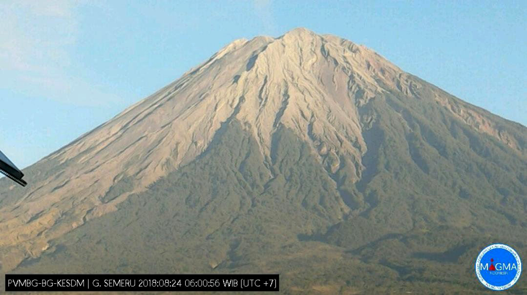 |
Figure 32. View looking NW at the quiet Mahameru summit area of Semeru on 24 August 2018 taken by a webcam courtesy of MAGMA Indonesia via Ø.L. Andersen's Twitter feed. |
While there were no observatory activity reports issued, the Darwin VAAC issued reports for five events that produced ash plumes to altitudes ranging 3.4 to 4.9 km (table 22). MIROVA (Middle InfraRed Observation of Volcanic Activity) thermal data indicate near-consistent low-level thermal activity at Semeru after a period of no detected thermal anomalies in late January through early February. This supports the elevated thermal energy detected by Sentinel-2 satellite data at the Jonggring-Seloko vent and along the SE-flank ravine (figure 34). The MODVOLC algorithm detected 16 high-temperature hotspots through the reporting period, six in January, two in March, three in April, one in July, and two in August through to the 24th.
Table 22. Summary of ash plumes (altitude and drift direction) and pyroclastic flows at Semeru, January to 24 August 2018. The summit is at 3,657 m elevation. Data courtesy of Darwin VAAC report.
| Date | Altitude (km) | Drift direction | Other notes |
| 24 Feb 2018 | 4.6 | 20 km ESE and WSW | -- |
| 29 Apr 2018 | 3.4 | NW | Short-lived discrete eruption |
| 20 Jul 2018 | 4.9 | SW | Minor discrete eruption |
| 30-31 Jul 2018 | 4.3 | W | -- |
| 23-24 Aug 2018 | 4.3 | W and SW | -- |
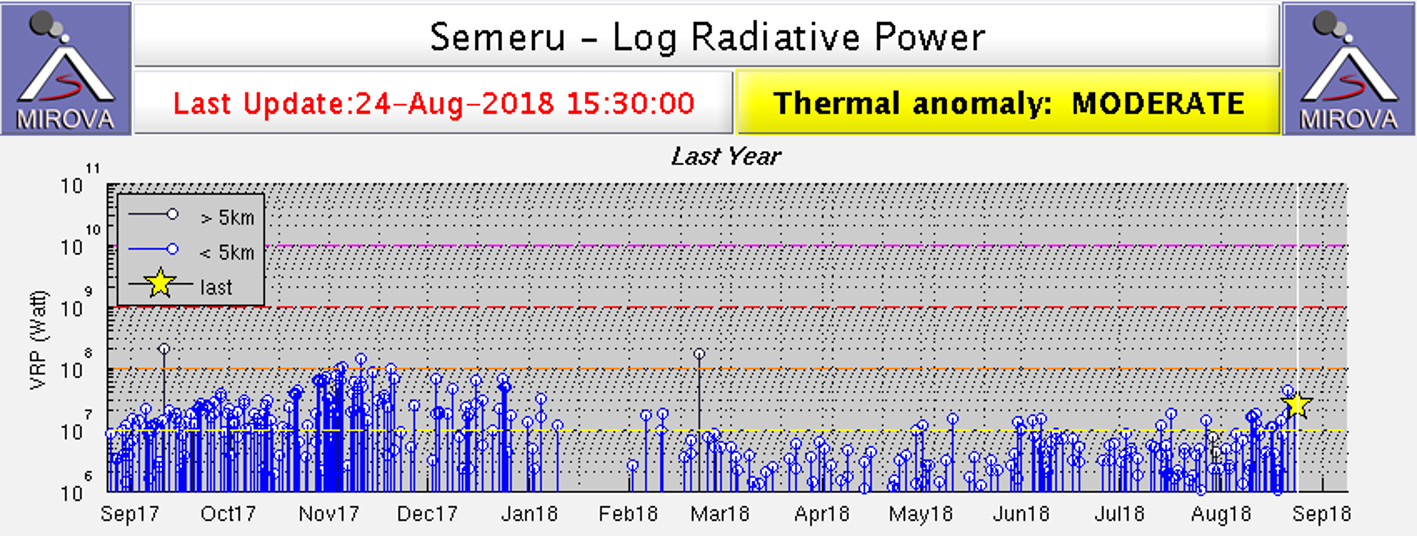 |
Figure 33. MIROVA plot of Log Radiative Power showing the relative thermal energy at Semeru ending September 2018. The detected thermal activity is more intense before mid-January 2018 when there was a gap in detected data before regular low-level activity resumed. Courtesy of MIROVA. |
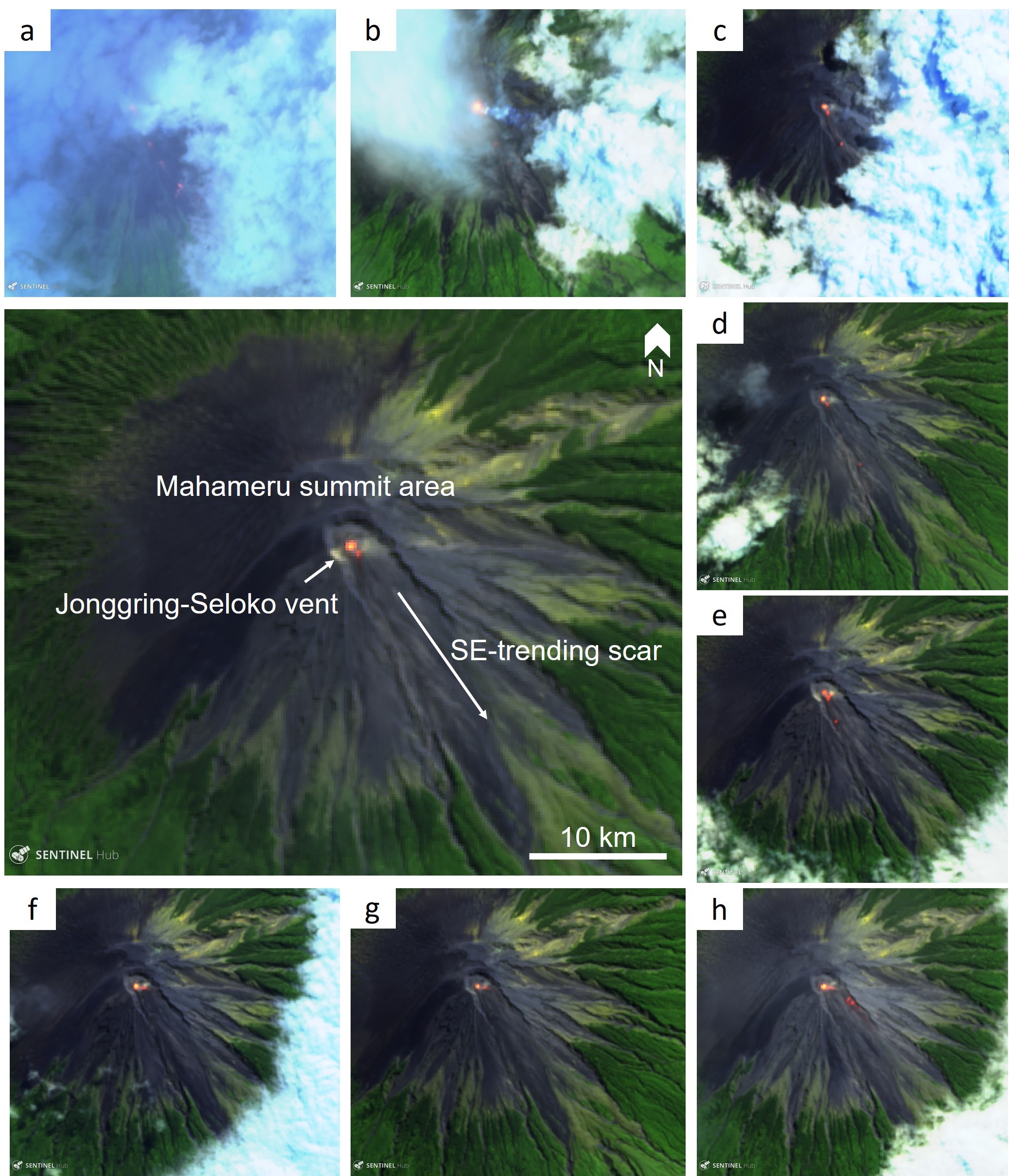 |
Figure 34. Sentinel-2 false color thermal satellite images showing the persistent elevated thermal anomaly in the Jonggring-Seloko crater of Semeru from January through to 24 August 2018. Hot material can sometimes be identified in the SE-flank ravine. The larger central image is annotated with the major morphological features. False color (urban) images (bands 12, 11, 4) courtesy of Sentinel Hub Playground. |
Geological Summary. Semeru, the highest volcano on Java, and one of its most active, lies at the southern end of a volcanic massif extending north to the Tengger caldera. The steep-sided volcano, also referred to as Mahameru (Great Mountain), rises above coastal plains to the south. Gunung Semeru was constructed south of the overlapping Ajek-ajek and Jambangan calderas. A line of lake-filled maars was constructed along a N-S trend cutting through the summit, and cinder cones and lava domes occupy the eastern and NE flanks. Summit topography is complicated by the shifting of craters from NW to SE. Frequent 19th and 20th century eruptions were dominated by small-to-moderate explosions from the summit crater, with occasional lava flows and larger explosive eruptions accompanied by pyroclastic flows that have reached the lower flanks of the volcano.
Information Contacts: Pusat Vulkanologi dan Mitigasi Bencana Geologi (PVMBG, also known as Indonesian Center for Volcanology and Geological Hazard Mitigation, CVGHM), Jalan Diponegoro 57, Bandung 40122, Indonesia (URL: http://www.vsi.esdm.go.id/); MAGMA Indonesia, Kementerian Energi dan Sumber Daya Mineral (URL: https://magma.vsi.esdm.go.id/); Darwin Volcanic Ash Advisory Centre (VAAC), Bureau of Meteorology, Northern Territory Regional Office, PO Box 40050, Casuarina, NT 0811, Australia (URL: http://www.bom.gov.au/info/vaac/); MIROVA (Middle InfraRed Observation of Volcanic Activity), a collaborative project between the Universities of Turin and Florence (Italy) supported by the Centre for Volcanic Risk of the Italian Civil Protection Department (URL: http://www.mirovaweb.it/); Hawai'i Institute of Geophysics and Planetology (HIGP) - MODVOLC Thermal Alerts System, School of Ocean and Earth Science and Technology (SOEST), Univ. of Hawai'i, 2525 Correa Road, Honolulu, HI 96822, USA (URL: http://modis.higp.hawaii.edu/); Sentinel Hub Playground (URL: https://www.sentinel-hub.com/explore/sentinel-playground); Øystein Lund Andersen? (Twitter: @OysteinLAnderse, https://twitter.com/OysteinLAnderse, URL: http://www.oysteinlundandersen.com).