Report on Fuego (Guatemala) — April 2019

Bulletin of the Global Volcanism Network, vol. 44, no. 4 (April 2019)
Managing Editor: Edward Venzke.
Edited by Janine B. Krippner.
Fuego (Guatemala) Frequent explosive activity with ash plumes, avalanches, lava flows, and lahars from July 2018 through March 2019
Please cite this report as:
Global Volcanism Program, 2019. Report on Fuego (Guatemala) (Krippner, J.B., and Venzke, E., eds.). Bulletin of the Global Volcanism Network, 44:4. Smithsonian Institution. https://doi.org/10.5479/si.GVP.BGVN201904-342090
Fuego
Guatemala
14.4748°N, 90.8806°W; summit elev. 3799 m
All times are local (unless otherwise noted)
Fuego is one of Guatemala's most active volcanoes, regularly producing ash plumes and incandescent ballistic ejecta, along with lava flows, avalanches, pyroclastic flows, and lahars down the ravines (barrancas) and rivers (figure 104). Frequent ash plumes have been recorded in recent years (figure 105). A major eruptive event occurred on 3-5 June that resulted in fatalities. Thermal data show an increase in activity from November 2018, that continued through the reporting period (figure 106). This report summarizes activity from July 2018 through March 2019 based on reports by Instituto Nacional de Sismologia, Vulcanología, Meteorología e Hidrologia (INSIVUMEH) and the National Office of Disaster Management (CONRED), Washington Volcanic Ash Advisory Center (VAAC), satellite data.
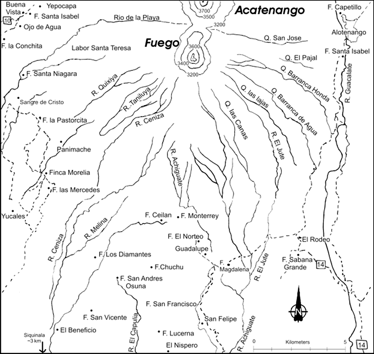 |
Figure 104. Map of Fuego showing the ravines, rivers, and communities. Map created in 2005 (see BGVN 30:08). |
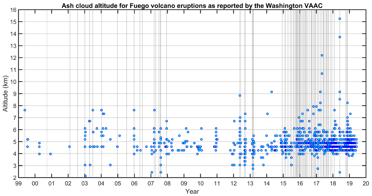 |
Figure 105. Ash plume altitudes from 1999 through 2019 for Fuego as reported by the Washington VAAC. The gray vertical lines represent paroxysmal eruptions. Courtesy of Rudiger Escobar Wolf, Michigan Technological University. |
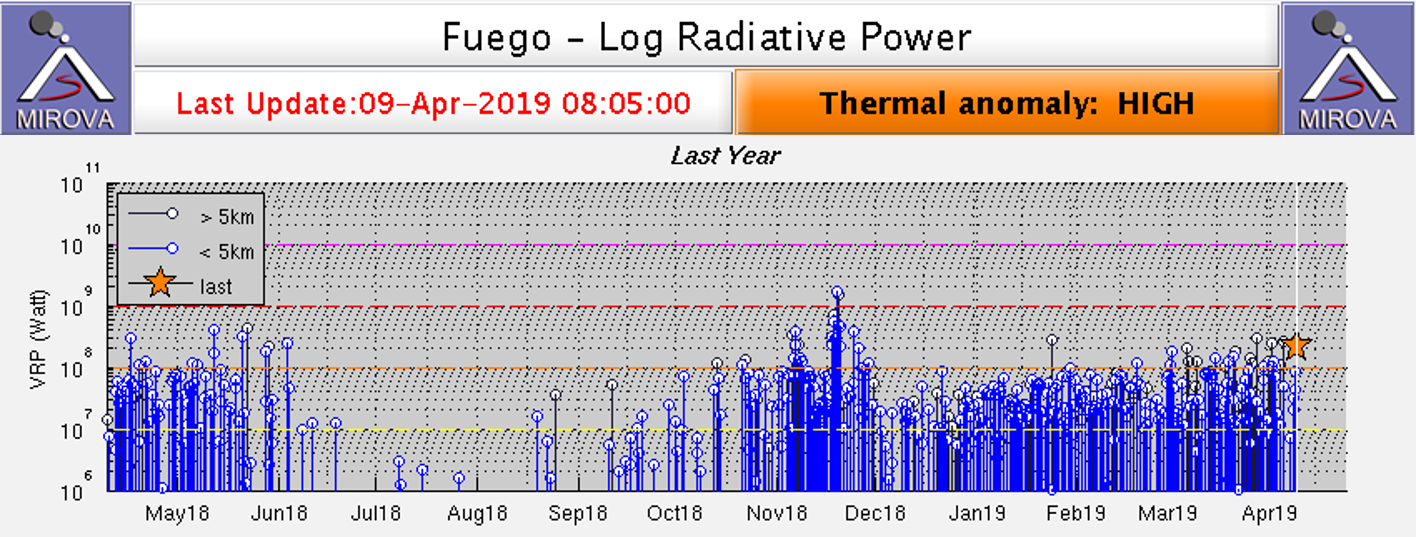 |
Figure 106. Log radiative power MIROVA plot of MODIS infrared data at Fuego for the year ending April 2019 showing increased activity since November 2018. Courtesy of MIROVA. |
Gas emissions and avalanches characterized activity in early July 2018; an increase was reported on the 4th. Avalanches descended through the Cenizas, Las Lajas, and Santa Teresa ravines on the 6th. One explosion every two hours on 8 July produced ash plumes up to 4.3 km altitude (500 m above the crater) that dispersed towards the SW. Avalanches down the flanks accompanied this activity. On 10 July ash plumes rose to 4.2 and 5 km altitude dispersing to the SW, and ashfall was reported in Morelia and Panimache (figure 107). Avalanches continued on the 19-20 and 23-24 July and weak explosions on the 23-24 produced low ash plumes that dispersed to the N. Hot lahars containing blocks 2-3 m in diameter and tree trunks and branches were generated in the Taniluyá, Ceniza, El Jute, and Las Lajas ravines on 30 and 31 July, and 2 and 9 August.
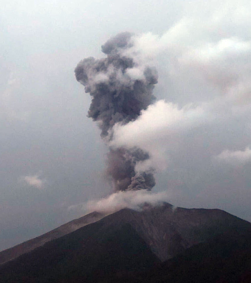 |
Figure 107. A moderate explosion produced an ash plume at Fuego on 10 July 2018. Photo courtesy of CONRED. |
During August and September, weak to moderate explosions produced ash plumes that rose to 4.7 km altitude and incandescent material was ejected to 150 m above the crater, producing avalanches down the ravines. Additional hot lahars carrying boulders and tree branches occurred on 29 August-2 September and 21-27 September down the Honda (E), El Jute (SE), Las Lajas (SE), Cenizas (SSW), Taniluyá (SW), Seca (W), Santa Teresa (W), Niagara (W), Mineral, and Pantaleón (W) drainages.
An increase in activity occurred on 29 September with degassing pulses lasting 3-4 hours recorded and heard. Avalanches occurred on the flanks and weak-moderate explosions occurred at a rate of 10-15 per hour with ash plumes rising up to 4.7 km. Hot lahars traveled down the Seca, Santa Teresa, and Mineral ravines, transporting blocks up to 3 m in diameter along with tree trunks and branches. Similar lahars were generated in the Las Lajas ravine on 5, 8, and 9 October (figure 108). The lahars were hot and smelled of sulfur, and they carried blocks 1-3 m in diameter.
On 12 October activity increased and produced incandescent ejecta up to 100-200 m above the crater and out to 300 m away from the crater, avalanches in the ravines, and a lava flow with a length of 800-1,000 m, that had reached 1,500 m by the 13th. Ash plumes reached 4.8 km altitude and dispersed up to 12 km towards the S and SE. Explosions occurred at a rate of 8-10 per hour with shockwaves that were reported near the volcano. At 1640 a pyroclastic flow was generated down the Seca ravine (figure 109). Similar activity continued through the 13th, with ash plumes reaching 5 km and ashfall reported in communities including Panimache I, Morelia, Santa Sofia, Sangre de Cristo, El Porvenir, and Palo Verde Estate. This episode of increased activity continued for 32 hours. Lahars traveled down the Ceniza and Seca ravines, the Achiguate River, and the Mineral and Taniluyá ravines (both tributaries of the Pantaleón river). A 30-m-wide lahar with a depth of 2 m was reported on 16 October that carried blocks up to 2 m in diameter, tree trunks, and branches. More lahars descended the Las Lajas ravine on the 17-18, and 20 October. Explosions continued through to the end of October, with increased activity on 31 October.
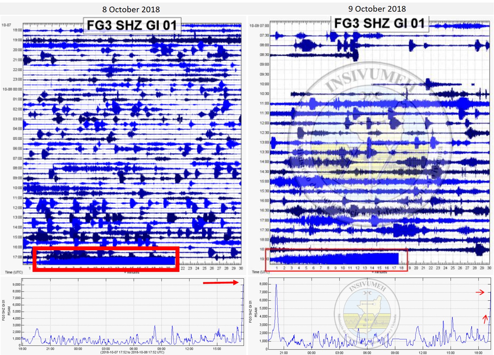 |
Figure 108. Seismograms and RSAM (Real-time Seismic Amplitude Measurement) graphs of activity at Fuego showing a change in signal indicative of lahars in the Las Lajas ravine on 8 and 9 October 2018 (red boxes and arrows). The change in seismic signal correlates with an increase in RSAM values. Courtesy of INSIVUMEH. |
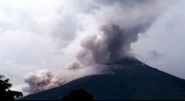 |
Figure 109. A pyroclastic flow at Fuego traveling down the Seca ravine on 12 October 2018. Courtesy of CONRED. |
Frequent activity continued into November with elevated activity reported on the 2 and 4-6 November. On 6 November ash plumes rose to 4.8 km altitude and traveled 20 km W and SW resulted in ashfall on communities including Panimache, El Porvenir, Morelia, Santa Sofia, Sangre de Cristo, Palo Verde Estate, and San Pedro Yepocapa. Constant explosions ejected incandescent material to 300 m above the crater. A lava flow 1-1.2 km long observed in the Ceniza ravine generated avalanches from the front of the flow, which continued through the 9th.
Activity increased again on 17 November, initiating the fifth eruptive phase of 2018. There were 10-15 explosions recorded per hour along with ash plumes up to 4.7 km that dispersed 10-15 km to the W and SW. Incandescent material was ejected up to 200-300 m above the crater, and avalanches were generated. A new lava flow reached 800 m down the Ceniza ravine. Ashfall was reported in Panimaché I, Morelia, Santa Sofia, El Porvenir, Sangre de Cristo, Palo Verde Estate, Yepocapa, and other communities.
The elevated activity continued through 18 November with 12-17 explosions per hour and a constant ash plume to 5 km altitude, dispersing to the W and SW for 20-25 km. Moderate avalanches traveled down the Ceniza, Taniluyá, and Seca ravines out to the vegetation line. Incandescent blocks were ejected up to 400 m above the crater. Ashfall was reported in communities including Panimaché I, Morelia, Santa Sofia, Sangre de Cristo, and Palo Verde Estate. Avalanches from the front of the lava flow traveled down the Taniluyá and Seca ravines.
Ash plumes rose to 7 km altitude on the 19th and dispersed 50-60 km towards the W, SW, and NE (figure 110). Incandescent ballistic ejecta reached 1 km above the crater and scattered to over 1 km from the crater (figure 111), with the explosions shaking houses over 15 km away to the W and SW, and avalanches moved down the Seca, Ceniza, Taniluyá, Las Lajas, and Honda ravines reaching the vegetation. Two new lava flows formed, extending to 300 m down the Seca and Santa Teresa ravines. Pyroclastic flows traveled down the Seca, Las Lajas, and Honda ravines. Ashfall due to the generation of pyroclastic flows was reported in Panimaché I and II, Santa Sofía, Sangre de Cristo, Palo Verde Estate, and in Alotenango and Antigua, Guatemala, to the NE. CONRED reported the evacuation of 3,925 people. INSIVUMEH reported that the eruption phase was over at 1800 on 19 November after 32 hours of increased activity.
 |
Figure 110. Eruption at Fuego on 19 November 2018 producing ash plumes and incandescent ejecta. Courtesy of European Pressphoto Agency via BBC News. |
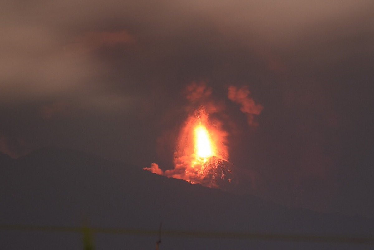 |
Figure 111. Explosions at Fuego on 19 November 2018 generated ash plumes to 5.2 km altitude, incandescent blocks up to 1 km above the crater, and avalanches. Courtesy of CONRED. |
Explosions continued through 20 November at a rate of 8-13 per hour, ejecting incandescent material up to 200 m above the crater and ash plumes to at least 4.6 km that drifted 20-25 km NW, W, and SW. Avalanches continued with some reaching the vegetation. Ashfall was reported in communities including Panimaché, El Porvenir, Morelia, Santa Sofia, Sangre de Cristo, Palo Verde Estate, and San Pedro Yepocapa.
Similar activity continued through to the end of November with explosions producing shockwaves felt out to 25 km; some explosions were heard in Guatemala City, 40 km ENE. Ash plumes rose to 5 km (figures 112 and 113) and dispersed 20 km W, S, and SW, and ash fell in communities including Panimaché, El Porvenir, Morelia, Santa Sofia, Sangre de Cristo, Palo Verde Estate, San Pedro Yepocapa, Alotenango, and San Miguel Dueñas. Explosions were recorded 10 to 18 per hour. Incandescent ejecta rose to 200 m above the crater and resulted in avalanches in the Las Lajas, Ceniza, El jute, Honda, Taniluyá, Trinidad, and Seca ravines with some reaching the vegetation line. Some avalanches entrained large blocks up to 3 m in diameter that produced ash plumes as they traveled down the ravines. Hot lahars were generated in the Seca, Santa Maria, and Mineral ravines, carrying blocks up to 3 m in diameter (figure 114).
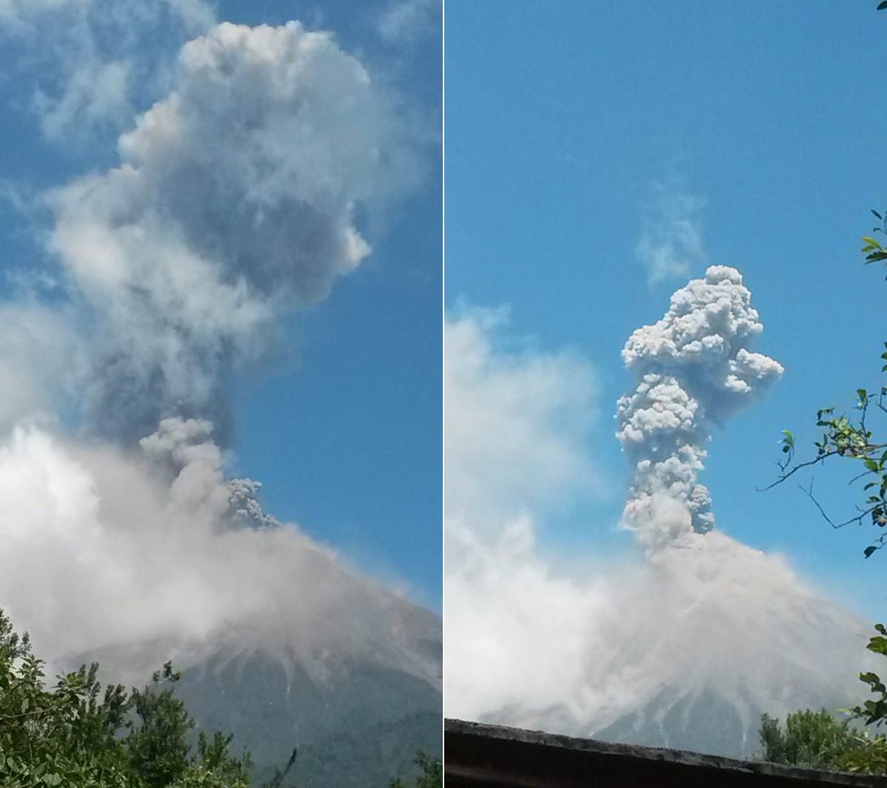 |
Figure 112. Explosions at Fuego generated ash plumes and caused avalanches in the Las Lajas, Trinidad, and Ceniza ravines on 22 November 2018. Courtesy of CONRED. |
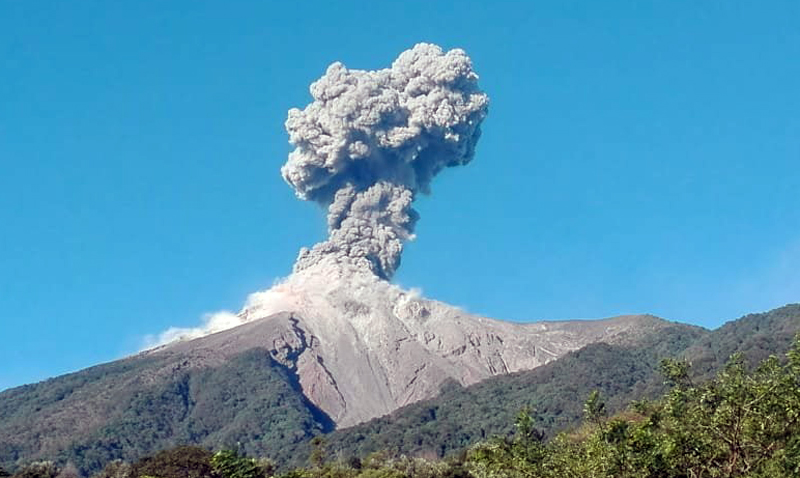 |
Figure 113. Ash plume up to 5.5 km altitude at Fuego on 28 November 2018. Courtesy of CONRED. |
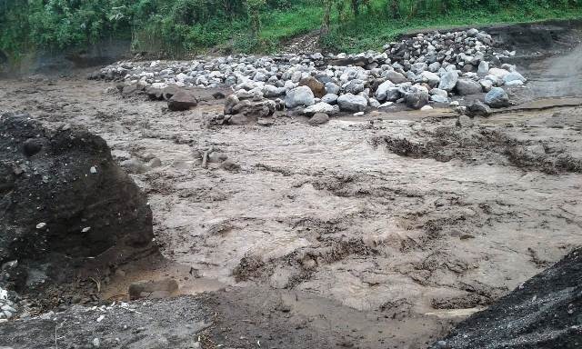 |
Figure 114. A lahar from Fuego traveling down the Mineral River in November 2018. Courtesy of CONRED. |
During December white to light gray fumarolic plumes rose to a maximum height of 4.5 km. Ash plumes reached up to 5.2 km and dispersed to a maximum of 25 km S, SW, and W. There were 3-15 explosions recorded per hour with shockwaves, incandescent ejecta reaching 300 m above the crater, and avalanches down the Seca, Taniluyá, Ceniza, Trinidad, Las Lajas, and Honda ravines. Ashfall was reported in communities including Panimaché I and II, Morelia, Santa Sofia, El Porvenir, Palo Verde Estate, Sangre de Cristo, Yepocapa, La Rochela, San Andrés Osuna, Ceylon, Alotenango, and San Pedro.
Similar activity continued through January 2019 with fumarolic plumes rising to a maximum of 4.4 km altitude, ash plumes reaching 4.8 km and dispersing over 15 km to the NE, WSW, and NW; 3-25 explosions per hour sent shockwaves and avalanches in multiple directions. Ashfall was reported in Panimaché, Morelia, Santa Sofia, Sangre de Cristo, Palo Verde Estate, and San Pedro Yepocapa. Also in Alotenango, La Reunion, and El Porvenir, Alotenango.
An increase in activity began on 21 January with moderate to strong explosions producing ash plumes up to 5 km altitude that dispersed 12 km W and SW. The explosions were heard over 15 km away and shook windows and roofs out to 12 km away. Avalanches were triggered in multiple ravines. On 22 January there were 15-25 recorded explosions per hour, each lasting 2-3 minutes and producing ash plumes to 4.8 km and incandescent ejecta up to 300 m above the crater (figure 115).
 |
Figure 115. An ash plume rising during an explosive event at Fuego on 22 January 2019. Courtesy of CONRED. |
Frequent explosions continued during February through to late-March, with a range of 8-18 per hour, producing ash plumes rising to 4.8 km (figure 116), and dispersing out to 15 km in multiple directions. Incandescent ejecta rose to 350 m above the crater and resulted in avalanches down multiple ravines. Ashfall was reported in communities including El Rodeo, El Zapote, Ceylon, La Roche-la, Panimache, Morelia, Santa Sofia, Sangre de Cristo, San Miguel Dueñas, Ciudad Vieja, and Alotenango, Verde Estate, San Pedro Yepocapa, La Rochelle, and San Andrés Osuna.
On 22 March there was an increase in the number and energy of explosions with 15-20 per hour. Accompanying ash plumes rose to 5 km altitude and dispersed 25-30 km S, W, SW, E, and SE, depositing ash in La Rochela, Ceylon, Osuna, Las Palmas, Siquinalá, and Santa Lucia Cotzumalguapa. Explosions were heard over 20 km from the volcano. Incandescent ejecta rose to 300 m above the crater and moderate to strong avalanches flowed down the Seca, Taniluyá, Ceniza, Trinidad, Las Lajas and Honda ravines. Explosions increased to 14-32 events per hour by 31 March, continuing to produce ash plumes up to 5 km and depositing ash on nearby communities and causing avalanches down the flanks. A new lava flow reached 800 m down the Seca ravine.
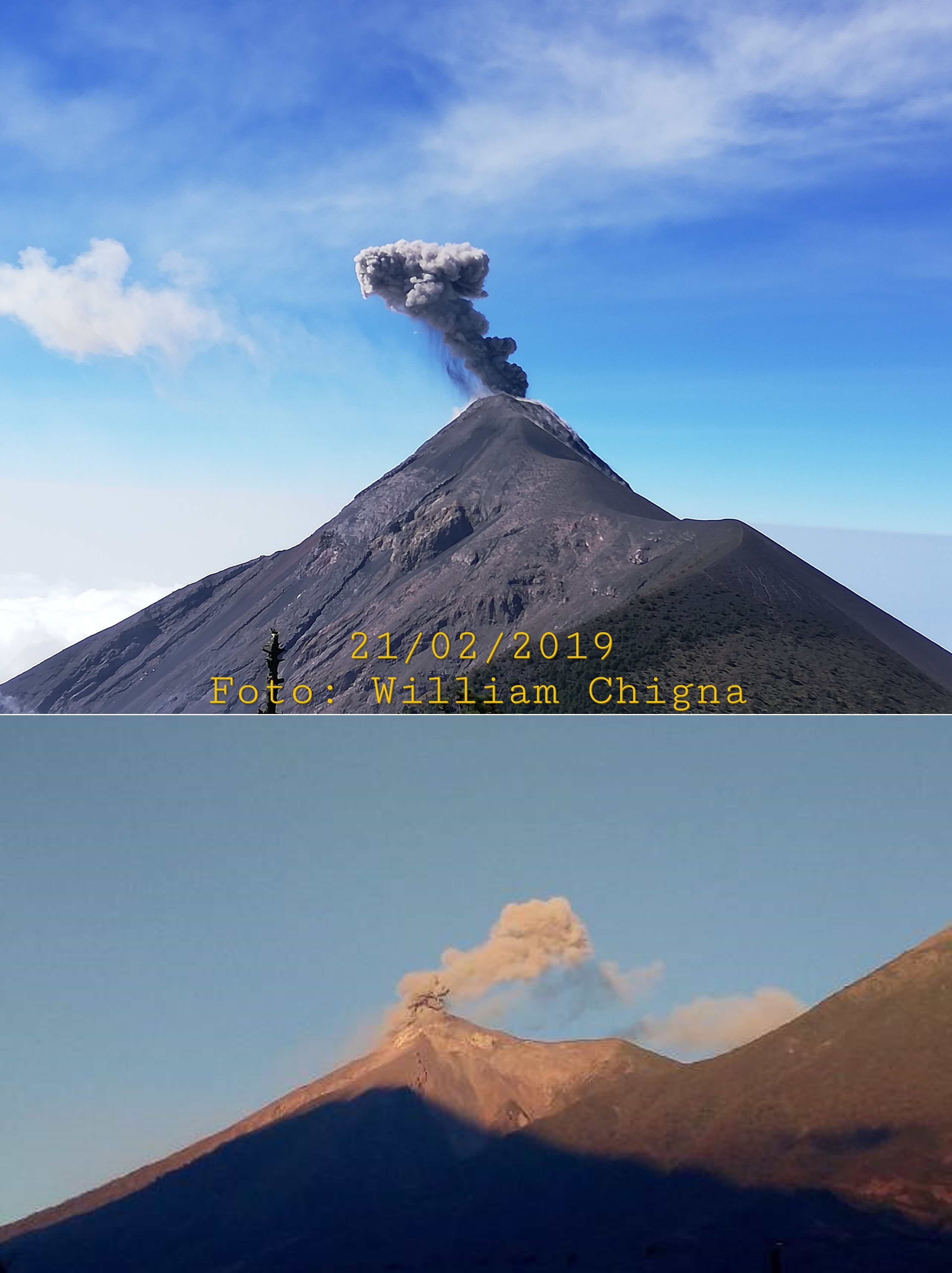 |
Figure 116. Examples of small ash plumes at Fuego on 21 February and 12 March 2019. Courtesy of William Chigna, CONRED (top) and CONRED (bottom). |
Geological Summary. Volcán Fuego, one of Central America's most active volcanoes, is also one of three large stratovolcanoes overlooking Guatemala's former capital, Antigua. The scarp of an older edifice, Meseta, lies between Fuego and Acatenango to the north. Construction of Meseta dates back to about 230,000 years and continued until the late Pleistocene or early Holocene. Collapse of Meseta may have produced the massive Escuintla debris-avalanche deposit, which extends about 50 km onto the Pacific coastal plain. Growth of the modern Fuego volcano followed, continuing the southward migration of volcanism that began at the mostly andesitic Acatenango. Eruptions at Fuego have become more mafic with time, and most historical activity has produced basaltic rocks. Frequent vigorous eruptions have been recorded since the onset of the Spanish era in 1524, and have produced major ashfalls, along with occasional pyroclastic flows and lava flows.
Information Contacts: Instituto Nacional de Sismologia, Vulcanologia, Meteorologia e Hydrologia (INSIVUMEH), Unit of Volcanology, Geologic Department of Investigation and Services, 7a Av. 14-57, Zona 13, Guatemala City, Guatemala (URL: http://www.insivumeh.gob.gt/); Coordinadora Nacional para la Reducción de Desastres (CONRED), Av. Hincapié 21-72, Zona 13, Guatemala City, Guatemala (URL: http://conred.gob.gt/www/index.php); Washington Volcanic Ash Advisory Center (VAAC), Satellite Analysis Branch (SAB), NOAA/NESDIS OSPO, NOAA Science Center Room 401, 5200 Auth Rd, Camp Springs, MD 20746, USA (URL: www.ospo.noaa.gov/Products/atmosphere/vaac, archive at: http://www.ssd.noaa.gov/VAAC/archive.html); Sentinel Hub Playground (URL: https://www.sentinel-hub.com/explore/sentinel-playground); MIROVA (Middle InfraRed Observation of Volcanic Activity), a collaborative project between the Universities of Turin and Florence (Italy) supported by the Centre for Volcanic Risk of the Italian Civil Protection Department (URL: http://www.mirovaweb.it/); Rudiger Escobar Wolf, Michigan Technologicla University, 630 Dow Environmental Sciences, 1400 Townsend Drive, Houghton, MI 49931, USA (URL: https://www.mtu.edu/geo/department/staff/wolf.html); William Chigna, CONRED (URL: https://twitter.com/william_chigna); BBC News (URL: https://www.bbc.com; https://www.bbc.com/news/world-latin-america-46261168?intlink_from_url=https://www.bbc.com/news/topics/c4n0j0d82l0t/guatemala-volcano&link_location=live-reporting-story); European Pressphoto Agency (URL: http://www.epa.eu/); Agence France-Presse (URL: http://www.afp.com/).