Report on Bagana (Papua New Guinea) — June 2019

Bulletin of the Global Volcanism Network, vol. 44, no. 6 (June 2019)
Managing Editor: Edward Venzke.
Edited by A. Elizabeth Crafford.
Bagana (Papua New Guinea) Infrequent thermal anomalies, no ash emissions, February-May 2019
Please cite this report as:
Global Volcanism Program, 2019. Report on Bagana (Papua New Guinea) (Crafford, A.E., and Venzke, E., eds.). Bulletin of the Global Volcanism Network, 44:6. Smithsonian Institution. https://doi.org/10.5479/si.GVP.BGVN201906-255020
Bagana
Papua New Guinea
6.137°S, 155.196°E; summit elev. 1855 m
All times are local (unless otherwise noted)
With historical eruptions reported back to 1842, Papua New Guinea's Bagana volcano on the island of Bougainville has been characterized by viscous andesitic lava flows down the steep flanks of its cone, along with intermittent ash plumes and pyroclastic flows. Ongoing thermal anomalies and frequent ash plumes have been typical of activity during the current eruption since it began in early 2000. Activity declined significantly in December 2018 and remained low through May 2019, the period covered in this report (figure 25). Information for this report comes primarily from satellite images and thermal data.
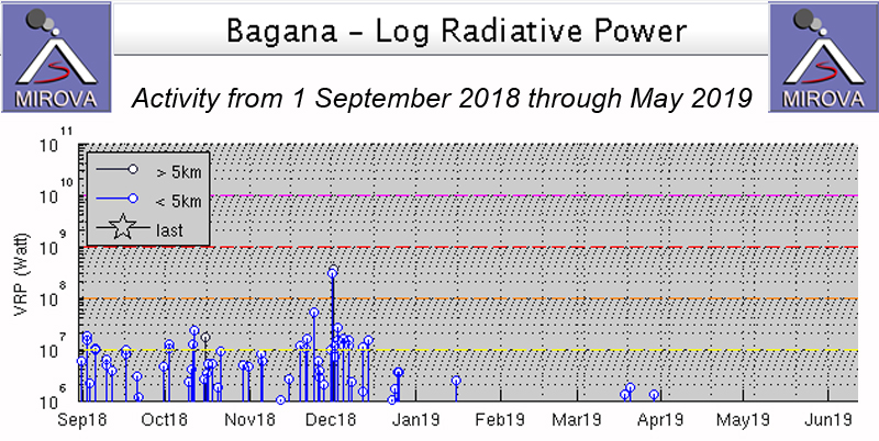 |
Figure 25. The MIROVA plot of radiative power at Bagana from 1 September 2018 through May 2019 shows a marked decline in thermal activity during December 2018 after ash explosions and satellite observations of flows during the previous months. Courtesy of MIROVA. |
The last ash emission at Bagana was reported on 1 December 2018 by the Darwin Volcanic Ash Advisory Center (VAAC). A Sentinel-2 satellite image showed a linear thermal anomaly trending NW from the summit on 14 December (BGVN 50:01). On 8 January 2019, an image contained a dense steam plume drifting E and a very faint thermal anomaly on the N flank a few hundred meters from the summit. A more distinct thermal anomaly at the summit appeared on 22 February 2019 (figure 26). A visitor to the region photographed incandescence on the flank, likely from the volcano, at dawn around 19 February 2019 (figure 27).
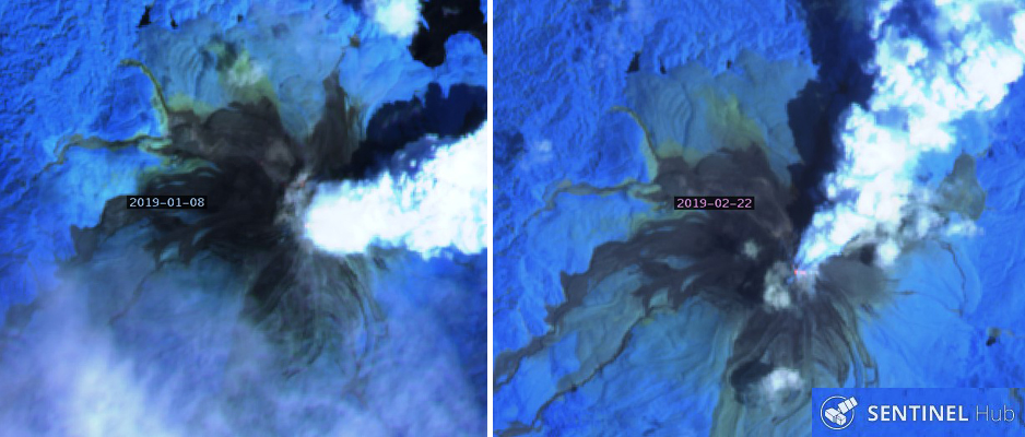 |
Figure 26. Sentinel-2 satellite imagery revealed thermal anomalies at Bagana in January and February 2019. Left: a very faint thermal anomaly was N of the summit at the edge of the E-drifting steam plume on 8 January 2019. Right: A thermal anomaly was located at the summit, at the base of the NE-drifting steam plume on 22 February 2019. Sentinel-2 satellite images with "Atmospheric Penetration" rendering (bands 12, 11, 8A). Courtesy of Sentinel Hub Playground. |
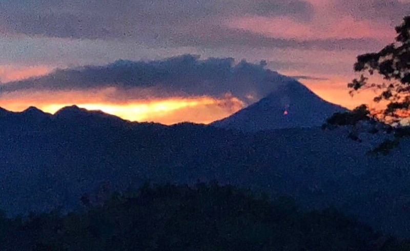 |
Figure 27. A visitor near Bagana spotted incandescence on the flank at dawn, possibly from a lava flow. Posted online 19 February 2019. Courtesy of Emily Stanford. |
Two faint thermal anomalies were visible at the summit in satellite imagery on 19 March; a single one appeared on 29 March 2019 (figure 28). No thermal anomalies were recorded in Sentinel-2 images during April or May, but steam plumes and gas emissions were visible through cloud cover on multiple occasions (figure 29).
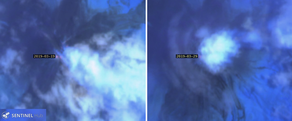 |
Figure 28. Faint thermal anomalies at Bagana were recorded in satellite imagery twice during March 2019. Left: 19 March, two anomalies appear right of the date label. Right: 29 March, a small anomaly appears right of the date label. Sentinel-2 image rendered with "Atmospheric Penetration" (bands 12, 11, 8A). Courtesy of Sentinel Hub Playground. |
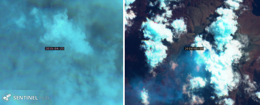 |
Figure 29. Steam and gas emissions at Bagana were recorded in satellite imagery during April and May 2019. Left: A steam plume drifted NW from the summit on 23 April, visible through dense cloud cover. Right: A gas plume drifted SW from the summit on 18 May. Sentinel-2 image with "Geology" rendering (bands 12, 4, 2). Courtesy of Sentinel Hub Playground. |
Geological Summary. Bagana volcano, in a remote portion of central Bougainville Island, is frequently active. This massive symmetrical cone was largely constructed by an accumulation of viscous andesitic lava flows. The entire edifice could have been constructed in about 300 years at its present rate of lava production. Eruptive activity is characterized by non-explosive effusion of viscous lava that maintains a small lava dome in the summit crater, although occasional explosive activity produces pyroclastic flows. Lava flows with tongue-shaped lobes up to 50 m thick and prominent levees descend the flanks on all sides.
Information Contacts: MIROVA (Middle InfraRed Observation of Volcanic Activity), a collaborative project between the Universities of Turin and Florence (Italy) supported by the Centre for Volcanic Risk of the Italian Civil Protection Department (URL: http://www.mirovaweb.it/); Darwin Volcanic Ash Advisory Centre (VAAC), Bureau of Meteorology, Northern Territory Regional Office, PO Box 40050, Casuarina, NT 0811, Australia (URL: http://www.bom.gov.au/info/vaac/); Sentinel Hub Playground (URL: https://www.sentinel-hub.com/explore/sentinel-playground); Emily Stanford (Twitter: https://twitter.com/NerdyBatLady, image posted at https://twitter.com/NerdyBatLady/status/1098052063009792001/photo/1).