Report on Agung (Indonesia) — June 2019

Bulletin of the Global Volcanism Network, vol. 44, no. 6 (June 2019)
Managing Editor: Edward Venzke.
Edited by A. Elizabeth Crafford.
Agung (Indonesia) Continued explosions with ash plumes and incandescent ejecta, February-May 2019
Please cite this report as:
Global Volcanism Program, 2019. Report on Agung (Indonesia) (Crafford, A.E., and Venzke, E., eds.). Bulletin of the Global Volcanism Network, 44:6. Smithsonian Institution. https://doi.org/10.5479/si.GVP.BGVN201906-264020
Agung
Indonesia
8.343°S, 115.508°E; summit elev. 2997 m
All times are local (unless otherwise noted)
After a large, deadly explosive and effusive eruption during 1963-64, Indonesia's Mount Agung on Bali remained quiet until a new eruption began in November 2017 (BGVN 43:01). Lava emerged into the summit crater at the end of November and intermittent ash plumes rose as high as 3 km above the summit through the end of the year. Activity continued throughout 2018 with explosions that produced ash plumes rising multiple kilometers above the summit, and the slow effusion of the lava within the summit crater (BGVN 43:08, 44:02). Information about the ongoing eruptive episode comes from Pusat Vulkanologi dan Mitigasi Bencana Geologi (PVMBG), also known as the Indonesian Center for Volcanology and Geological Hazard Mitigation (CVGHM), the Darwin Volcanic Ash Advisory Center (VAAC), and multiple sources of satellite data. This report covers the ongoing eruption from February through May 2019.
Intermittent but increasingly frequent and intense explosions with ash emissions and incandescent ejecta characterized activity at Agung during February through May 2019. During February, explosions were reported three times; events on seven days in March were documented with ash plumes and ashfall in surrounding villages. Five significant events occurred during April; two involved incandescent ejecta that traveled several kilometers from the summit, and ashfall tens of kilometers from the volcano. Most of the five significant events reported in May involved incandescent ejecta and ashfall in adjacent villages; air traffic was disrupted during the 24 May event. Ash plumes in May reached altitudes over 7 km multiple times. Thermal activity increased steadily during the period, according to both the MIROVA project (figure 44) and MODVOLC thermal alert data. MAGMA Indonesia reported at the end of May 2019 that the volume of lava within the summit crater remained at about 25 million m3; satellite information indicated continued thermal activity within the crater. Alert Level III (of four levels) remained in effect throughout the period with a 4 km exclusion radius around the volcano.
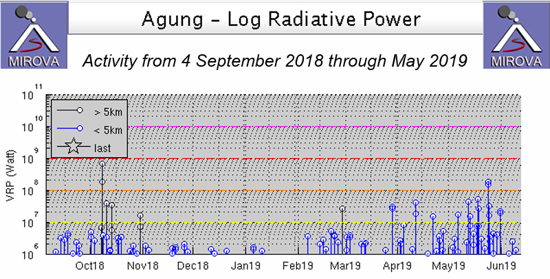 |
Figure 44. Thermal activity at Agung from 4 September 2018 through May 2019 was variable. The increasing frequency and intensity of thermal events was apparent from February-May. Courtesy of MIROVA. |
Steam plumes rose 30-300 m high daily during February 2019. The Agung Volcano Observatory (AVO) and PVMBG issued a VONA on 7 February (UTC) reporting an ash plume, although it was not visible due to meteoric cloud cover. Incandescence, however, was observed at the summit from webcams in both Rendang and Karangasem City (16 km SE). The seismic event associated with the explosion lasted for 97 seconds. A similar event on 13 February was also obscured by clouds but produced a seismic event that lasted for 3 minutes and 40 seconds, and ashfall was reported in the village of Bugbug, about 20 km SE. On 22 February a gray ash plume rose 700 m from the summit during a seismic event that lasted for 6 minutes and 20 seconds (figure 45). The Darwin VAAC reported the plume visible in satellite imagery moving W at 4.3 km altitude. It dissipated after a few hours, but a hotspot remained visible about 10 hours later.
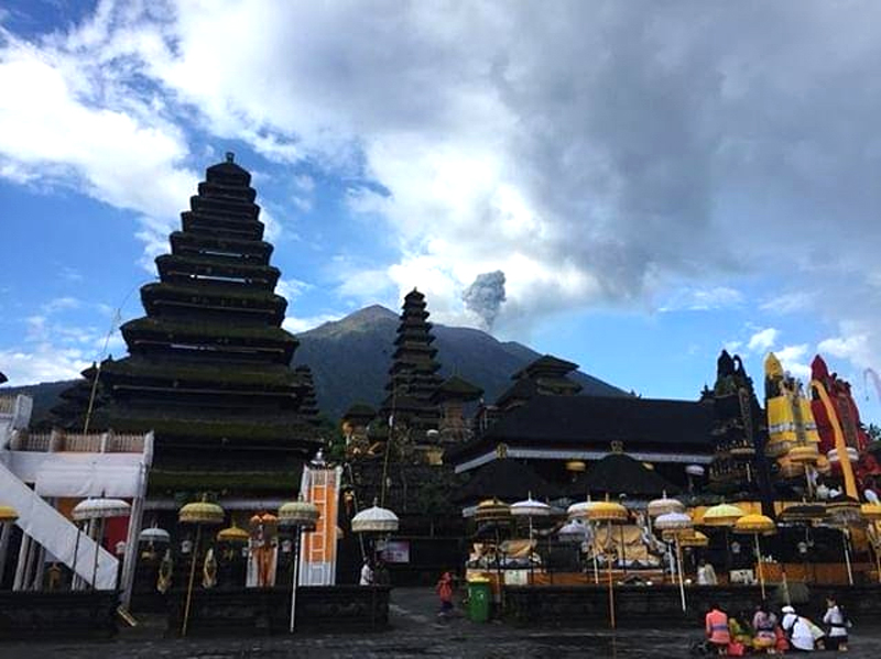 |
Figure 45. An ash plume rose from the summit of Agung on 22 February 2019, viewed from the Besakih temple, 7 km SW of the summit. Courtesy of PunapiBali. |
Persistent steam plumes rose 50-500 m from the summit during March 2019. An explosion on 4 March was recorded for just under three minutes and produced ashfall in Besakih (7 km SW); no ash plume was observed due to fog. A short-lived ash plume rose to 3.7 km altitude and drifted SE on 8 March (UTC) 2019. The seismic event lasted for just under 4 minutes. Ash emissions were reported on 15 and 17 March to 4.3 and 3.7 km altitude, respectively, drifting W (figure 46). Ashfall from the 15 March event spread NNW and was reported in the villages of Kubu (6 km N), Tianyar (14 km NNW), Ban, Kadundung, and Sukadana. MAGMA Indonesia noted that two explosions on the morning of 17 March (local time) produced gray plumes; the first sent a plume to 500 m above the summit drifting E and lasted for about 40 seconds, while the second plume a few hours later rose 600 m above the crater and lasted for 1 minute and 16 seconds. On 18 March an ash plume rose 1 km and drifted W and NW. An event on 20 March was measured only seismically by PVMBG because fog prevented observations. An eruption on 28 March produced an ash plume 2 km high that drifted W and NW. The seismic signal for this event lasted for about two and a half minutes. The Darwin VAAC reported the ash plume at 5.5 km altitude, dissipating quickly to the NW. No ash was visible four hours later, but a thermal anomaly remained at the summit (figure 47). Ashfall was reported in nearby villages.
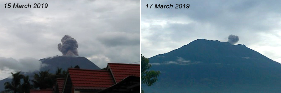 |
Figure 46. Ash plumes from Agung on 15 (left) and 17 (right) March 2019 resulted in ashfall in communities 10-20 km from the volcano. Courtesy of PVMBG and MAGMA Indonesia (Information on G. Agung Eruption, 15 March 2019 and Gunung Agung Eruption Press Release March 17, 2019). |
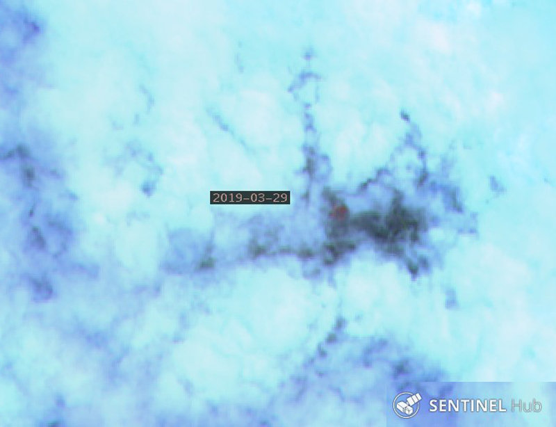 |
Figure 47. A thermal anomaly was visible through thick cloud cover at the summit of Agung on 29 March 2019 less than 24 hours after a gray ash plume was reported 2,000 m above the summit. "Atmospheric Penetration" rendering (bands 12, 11, and 8A) courtesy of Sentinel Hub Playground. |
The first explosion of April 2019 occurred on the 3rd (UTC); PVMBG reported the dense gray ash plume 2 km above the summit drifting W. A few hours later the Darwin VAAC raised the altitude to 6.1 km based on infrared temperatures in satellite imagery. The seismic signal lasted for three and a half minutes and the explosion was heard at the PGA Post in Rendang (12 km SW). Incandescent material fell within a radius of 2-3 km, mainly on the S flank (figure 48). Ashfall was reported in the villages of Telungbuana, Badeg, Besakih, Pempatan, Teges, and Puregai on the W and S flanks (figure 49). An explosion on 11 April also produced a dense gray ash plume that rose 2 km above the summit and drifted W. A hotspot remained about six hours later after the ash dissipated.
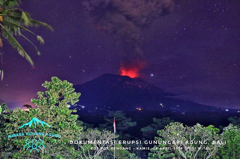 |
Figure 48. Incandescent ejecta appeared on the flanks of Agung after an eruption on 4 April 2019 (local time) as viewed from the observation post in Rendang (8 km SW). Courtesy of Jamie Sincioco. |
 |
Figure 49. Ashfall in a nearby town dusted mustard plants on 4 April 2019 from an explosion at Agung the previous day. Courtesy of Pantau.com (Photo: Antara / Nyoman Hendra). |
PVMBG reported an eruption visible in the webcam early on 21 April (local time) that rose to 5.5 km altitude and drifted SW. The ash spread W and S and ash fell around Besakih (7 km SW), Rendang (8 km SW), Klungkung (25 km S), Gianyar (20 km WSW), Bangli (17 km WNW), Tabanan (50 km WSW), and at the Ngurah Rai-Denpasar Airport (60 km SW). About 15 hours later a new explosion produced a dense gray ash plume that rose to 3 km above the summit and produced incandescent ejecta in all directions as far as 3 km away (figure 50). The ash spread to the S and ashfall was reported in Besakih, Rendang, Sebudi (6 km SW), and Selat (12 km SSW). Both of the explosions were heard in Rendang and Batulompeh. The incandescent ejecta from the explosions remained within the 4-km exclusion zone. A satellite image on 23 April showed multiple thermal anomalies within the summit crater (figure 51). A dense gray plume drifted E from Agung on 29 April (30 April local time) at 4.6 km altitude. It was initially reported by ground observers, but was also visible in multispectral satellite imagery for about six hours before dissipating.
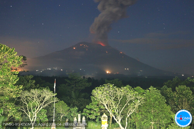 |
Figure 50. An explosion at Agung on 21 April 2019 sent incandescent eject 3,000 m from the summit. Courtesy of MAGMA Indonesia (Gunung Agung Eruption Press Release April 21, 2019). |
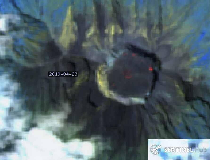 |
Figure 51. Multiple thermal anomalies were still present within the summit crater of Agung on 23 April 2019 after two substantial explosions produced ash and incandescent ejecta around the summit two days earlier. "Atmospheric Penetration" rendering (bands 12, 11, and 8A) courtesy of Sentinel Hub Playground. |
PVMBG reported an eruption on 3 May 2019 that was recorded on a seismogram with a signal that lasted for about a minute. Satellite imagery reported by the Darwin VAAC showed a growing hotspot and possible ash near the summit at 4.3 km altitude moving NE. A few days later, on 6 May, a gray ash plume rose to 5.2 km altitude and drifted slowly W before dissipating; it was accompanied by a seismic signal that lasted for about two minutes. Explosions on 12 and 18 May produced significant amounts of incandescent ejecta (figure 52). The seismic signal for the 12 May event lasted for about two minutes; no plume was observed due to fog, but incandescent ejecta was visible on the flanks and the explosion was heard at Rendang. The Darwin VAAC reported an ash plume from the explosion on 17 May (18 May local time) at 6.1 km altitude in satellite imagery moving E. They revised the altitude a short while later to 7.6 km based on IR temperature and movement; the plume drifted N, NE, and E in light and variable winds. A few hours after that it was moving NE at 7.6 km altitude and SE at 5.5 km altitude; this lasted for about 12 hours until it dissipated. Ashfall was reported in villages downwind including Cutcut, Tongtongan, Bonyoh (20 km WNW), and Temakung.
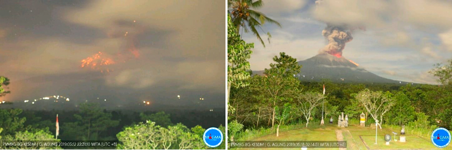 |
Figure 52. Explosions on 12 (left) and 18 (right) May (local time) 2019 produced substantial ejecta on the flanks of Agung visible from a distance of 10 km or more in PVMBG webcams. The ash plume from the 18 May event resulted in ashfall in numerous communities downwind. Courtesy of PVMBG (Information Eruption G. Agung, May 13, 2019, Information Eruption G. Agung, May 18, 2019). |
The initial explosion on 18 May was captured by a webcam at a nearby resort and sent incandescent ejecta hundreds of meters down the NE flank within 20 seconds (figure 53). Satellite imagery on 3, 8, 13, and 18 May indicated multiple thermal anomalies growing stronger at the summit. All of the images were captured within 24 hours of an explosive event reported by PVMBG (figure 54).
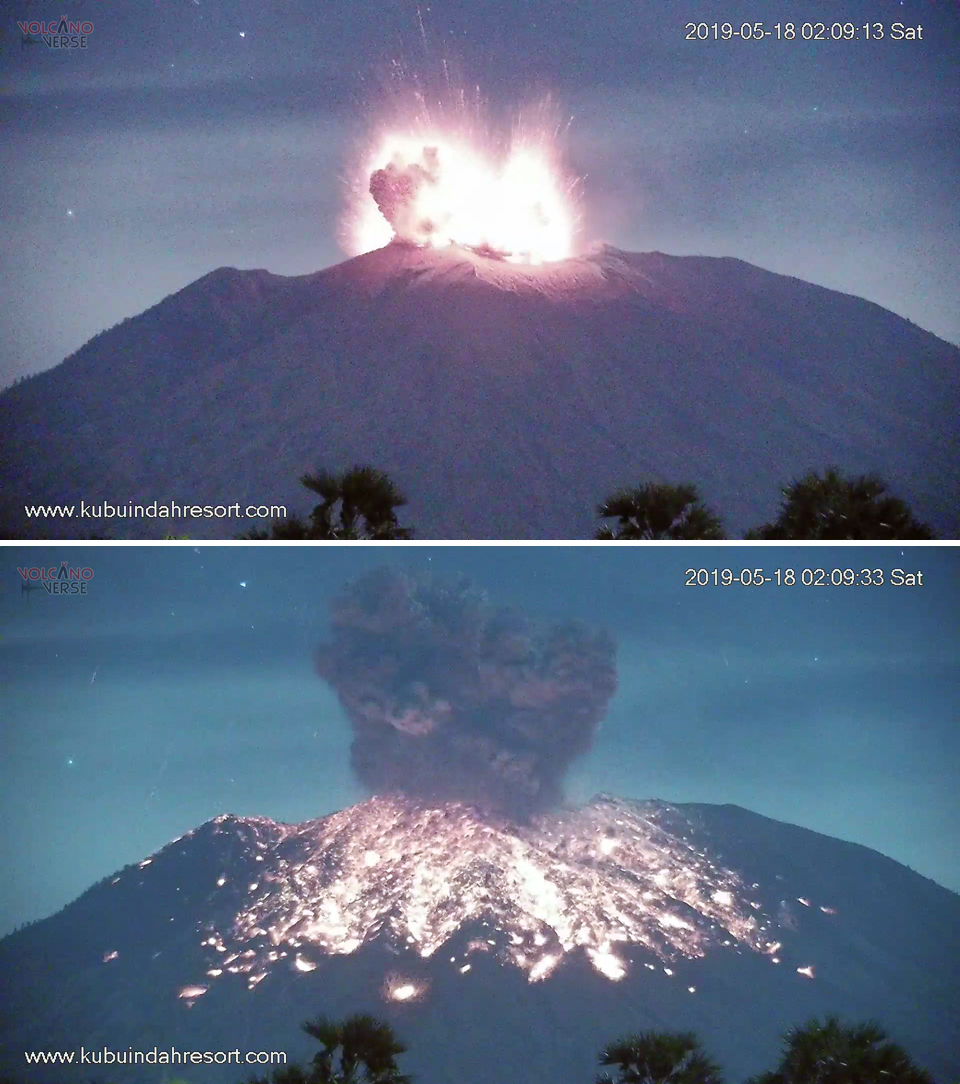 |
Figure 53. The 18 May 2019 explosion at Agung produced an ash plume that rose to over 7 km altitude and large bombs of incandescent material that traveled hundreds of meters down the NE flank within the first 20 seconds of the explosion. Images taken from a private webcam located 12 km NE. Courtesy of Volcanoverse, used with permission. |
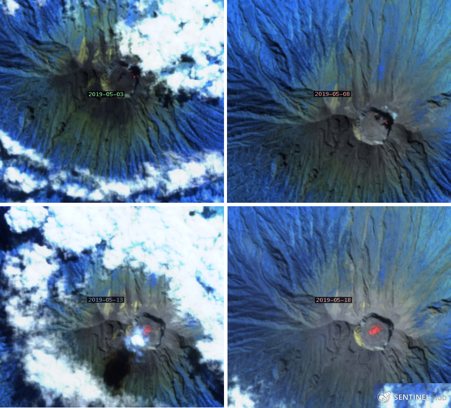 |
Figure 54. Satellite images from 3, 8, 13, and 18 May 2019 at Agung showed persistent and increasing thermal anomalies within the summit crater. All images were captured within 24 hours of explosions reported by PVMBG. "Atmospheric Penetration" rendering (bands 12, 11, and 8A) courtesy of Sentinel Hub Playground. |
PVMBG issued a VONA on 24 May 2019 reporting a new ash emission. They indicated that incandescent fragments were ejected 2.5-3 km in all directions from the summit, and the seismic signal lasted for four and a half minutes (figure 55). A dense gray ash plume was observed from Tulamben on the NE flank rising 2 km above the summit. Satellite imagery indicated that the plume drifted SW and ashfall was reported in the villages of Besakih, Pempatan, Menanga, Sebudi, Muncan, Amerta Bhuana, Nongan, Rendang, and at the Ngurah Rai Airport in Denpassar. Additionally, ashfall was reported in the districts of Tembuku, Bangli, and Susut (20 km SW). The Darwin VAAC reported an ash plume visible in satellite imagery at 4.6 km altitude along with a thermal anomaly and incandescent lava visible in webcam imagery. The remains of the ash plume were about 170 km S of the airport in Denpasar (60 km SW) and had nearly dissipated 18 hours after the event. According to a news article several flights to and from Australia were cancelled or diverted, though the International Gusti Ngurah Rai (IGNR) airport was not closed. On 31 May another large explosion produced the largest ash plume of the report period, rising more than 2 km above the summit (figure 56). The Darwin VAAC reported its altitude as 8.2 km drifting ESE visible in satellite data. It split into two plumes, one drifted E at 8.2 km and the other ESE at 6.1 km altitude, dissipating after about 20 hours.
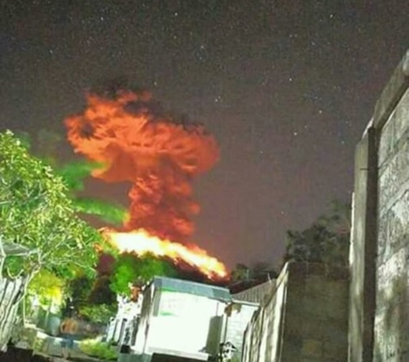 |
Figure 55. A large explosion at Agung on 24 May 2019 produced incandescent ejecta that covered all the flanks and dispersed ash to many communities to the SW. Courtesy of PVMBG (Gunung Agung Eruption Press Release 24 May 2019 20:38 WIB, Kasbani, Ir., M.Sc.). |
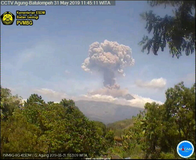 |
Figure 56. An explosion at Agung on 31 May 2019 sent an ash plume to 8.2 km altitude, the highest for the report period. Courtesy of Sutopo Purwo Nugroho, BNPB. |
Geological Summary. Symmetrical Agung stratovolcano, Bali's highest and most sacred mountain, towers over the eastern end of the island. The volcano, whose name means "Paramount," rises above the SE rim of the Batur caldera, and the northern and southern flanks extend to the coast. The summit area extends 1.5 km E-W, with the high point on the W and a steep-walled 800-m-wide crater on the E. The Pawon cone is located low on the SE flank. Only a few eruptions dating back to the early 19th century have been recorded in historical time. The 1963-64 eruption, one of the largest in the 20th century, produced voluminous ashfall along with devastating pyroclastic flows and lahars that caused extensive damage and many fatalities.
Information Contacts: Pusat Vulkanologi dan Mitigasi Bencana Geologi (PVMBG, also known as Indonesian Center for Volcanology and Geological Hazard Mitigation, CVGHM), Jalan Diponegoro 57, Bandung 40122, Indonesia (URL: http://www.vsi.esdm.go.id/); MAGMA Indonesia, Kementerian Energi dan Sumber Daya Mineral (URL: https://magma.vsi.esdm.go.id/); MIROVA (Middle InfraRed Observation of Volcanic Activity), a collaborative project between the Universities of Turin and Florence (Italy) supported by the Centre for Volcanic Risk of the Italian Civil Protection Department (URL: http://www.mirovaweb.it/); Sentinel Hub Playground (URL: https://www.sentinel-hub.com/explore/sentinel-playground); The Jakarta Post, Mount Agung eruption disrupts Australian flights, (URL: https://www.thejakartapost.com/news/2019/05/25/mount-agung-eruption-disrupts-australian-flights.html); PunapiBali (URL: http://punapibali.com/, Twitter: https://twitter.com/punapibali, image at https://twitter.com/punapibali/status/1098869352588288000/photo/1); Jamie S. Sincioco, Phillipines (Twitter @jaimessincioco, Image at https://twitter.com/jaimessincioco/status/1113765842557104130/photo/1); Pantau.com (URL: https://www.pantau.com/berita/erupsi-gunung-agung-sebagian-wilayah-bali-terpapar-hujan-abu?utm_source=dlvr.it&utm_medium=twitter); Volcanoverse (URL: https://www.youtube.com/channel/UCi3T_esus8Sr9I-3W5teVQQ); Sutopo Purwo Nugroho, BNPB (Twitter: @Sutopo_PN, URL: https://twitter.com/Sutopo_PN ).