Report on Sinabung (Indonesia) — August 2019

Bulletin of the Global Volcanism Network, vol. 44, no. 8 (August 2019)
Managing Editor: Edward Venzke.
Edited by A. Elizabeth Crafford.
Sinabung (Indonesia) Large ash explosions on 25 May and 9 June 2019
Please cite this report as:
Global Volcanism Program, 2019. Report on Sinabung (Indonesia) (Crafford, A.E., and Venzke, E., eds.). Bulletin of the Global Volcanism Network, 44:8. Smithsonian Institution. https://doi.org/10.5479/si.GVP.BGVN201908-261080
Sinabung
Indonesia
3.17°N, 98.392°E; summit elev. 2460 m
All times are local (unless otherwise noted)
Indonesia's Sinabung volcano in north Sumatra has been highly active since its first confirmed Holocene eruption during August and September 2010. It remained quiet after the initial eruption until September 2013, when a new eruptive phase began that continued uninterrupted through June 2018. Ash plumes often rose several kilometers, avalanche blocks fell kilometers down the flanks, and deadly pyroclastic flows traveled more than 4 km repeatedly during the eruption. After a pause in eruptive activity from July 2018 through April 2019, explosions took place again during May and June 2019. This report covers activity from July 2018 through July 2019 with information provided by Pusat Vulkanologi dan Mitigasi Bencana Geologi (PVMBG), referred to by some agencies as CVGHM or the Indonesian Center of Volcanology and Geological Hazard Mitigation, the Darwin Volcanic Ash Advisory Centre (VAAC), and the Badan Nacional Penanggulangan Bencana (National Disaster Management Authority, BNPB). Additional information comes from satellite instruments and local news reports.
After the last ash emission observed on 5 July 2018, activity diminished significantly. Occasional thermal anomalies were observed in satellite images in August 2018, and February-March 2019. Seismic evidence of lahars was recorded almost every month from July 2018 through July 2019. Renewed explosions with ash plumes began in early May; two large events, on 24 May and 9 June, produced ash plumes observed in satellite data at altitudes greater than 15 km (table 9).
Table 9. Summary of activity at Sinabung during July 2018-July 2019. Steam plume heights from PVMBG daily reports. VONA reports issued by Sinabung Volcano Observatory, part of PVMBG. Satellite imagery from Sentinel-2. Lahar seismicity from PVMBG daily and weekly reports. Ash plume heights from VAAC reports. Pyroclastic flows from VONA reports.
| Month | Steam Plume Heights (m) | Dates of VONA reports | Satellite Thermal Anomalies (date) | Seismicity indicating Lahars (date) | Ash Plume Altitude (date and distance) | Pyroclastic flows |
| Jul 2018 | 100-700 | -- | -- | -- | -- | -- |
| Aug 2018 | 50-700 | -- | 30 | 1, 20 | -- | -- |
| Sep 2018 | 100-500 | -- | -- | 1st week, 12, 29 | -- | -- |
| Oct 2018 | 50-1,000 | -- | -- | 1 | -- | -- |
| Nov 2018 | 50-350 | -- | -- | 14 | -- | -- |
| Dec 2018 | 50-500 | -- | -- | 30 | -- | -- |
| Jan 2019 | 50-350 | -- | -- | -- | -- | -- |
| Feb 2019 | 100-400 | -- | 6, 21 | -- | -- | -- |
| Mar 2019 | 50-300 | -- | 3, 8 | 27 | -- | -- |
| Apr 2019 | 50-400 | -- | -- | 2, 4, 11 | -- | -- |
| May 2019 | 200-700 | 7, 11, 12, 24, 26, 27 (2) | -- | 4, 14 | 7 (4.6 km), 24 (15.2 km), 25 (6.1 km) | -- |
| June 2019 | 50-600 | 9, 10 | -- | -- | 9 (16.8 km), 10 (3.0 km) | 9-3.5 km SE, 3.0 km S |
| July 2019 | 100-700 | -- | -- | 10, 12, 14, 16, 4th week | -- | -- |
No eruptive activity was reported after 5 July 2018 for several months, however Sentinel-2 thermal imagery on 30 August indicated a hot spot at the summit suggestive of eruptive activity. The next distinct thermal signal appeared on 6 February 2019, with a few more in late February and early March (figure 66, see table 9).
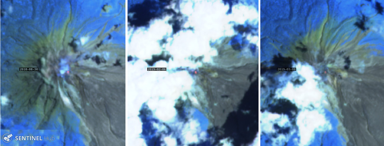 |
Figure 66. Sentinel-2 satellite imagery on 30 August 2018, 6 February, and 8 March 2019 showed distinct thermal anomalies suggestive of eruptive activity at Sinabung, although no activity was reported by PVMBG. Images rendered with Atmospheric Penetration, bands 12, 11, and 8A. Courtesy of Sentinel Hub Playground. |
PVMBG reported the first ash emission in 11 months early on 7 May 2019. They noted that an ash plume rose 2 km above the summit and drifted ESE. The Sinabung Volcano Observatory (SVO) issued a VONA (Volcano Observatory Notice for Aviation) that described an eruptive event lasting for a little over 40 minutes. Ashfall was reported in several villages. The Jakarta Post reported that Karo Disaster Mitigation Agency (BPDB) head Martin Sitepu said four districts were affected by the eruption, namely Simpang Empat (7 km SE), Namanteran (5 km NE), Kabanjahe (14 km SE), and Berastadi (12 km E). The Darwin VAAC reported the ash plume at 4.6 km altitude and noted that it dissipated about six hours later (figure 67). The TROPOMI SO2 instrument detected an SO2 plume shortly after the event (figure 68).
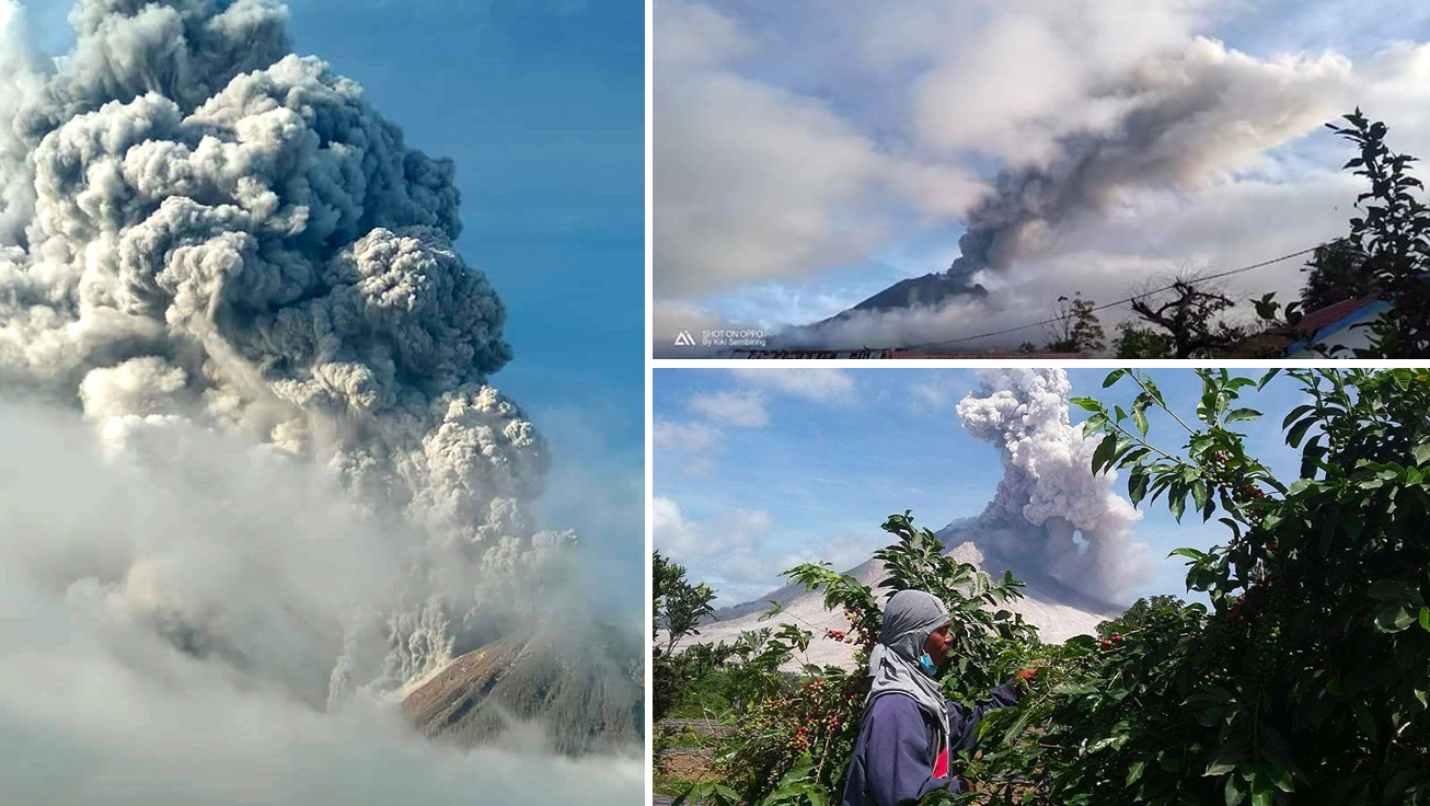 |
Figure 67. Images from the explosion at Sinabung on 7 May 2019. Left and bottom right photos by Kopi Cimbang and Kalak Karo Kerina, courtesy of David de Zabedrosky. Top right photo courtesy of Sutopo Purwo Nugroho, BNPB. |
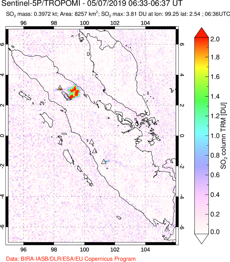 |
Figure 68. The TROPOMI instrument on the Sentinel-5P satellite captured an SO2 emission from Sinabung shortly after the eruption on 7 May 2019. Courtesy of NASA Goddard Space Flight Center. |
On 11 May 2019 SVO issued a VONA reporting a seismic eruption event with a 9 mm amplitude that lasted for about 30 minutes; clouds and fog prevented visual confirmation. Another VONA issued the following day reported an ash emission that lasted for 28 minutes but again was not observed due to fog. The Darwin VAAC did not observe the ash plumes reported on 11 or 12 May; they did report incandescent material observed in the webcam on 11 May. Sutopo Purwo Nugroho of BNPB reported that the 12 May eruption was accompanied by incandescent lava and ash, and the explosion was heard in Rendang (figure 69). The Alert Level had been at Level IV since 2 June 2015. Based on decreased seismicity, a decrease in visual activity (figure 70), stability of deformation data, and a decrease in SO2 flux during the previous 11 months, PVMBG lowered the Alert Level from IV to III on 20 May 2019.
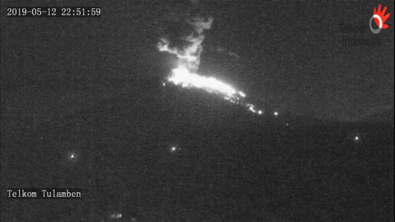 |
Figure 69. Incandescent lava and ash were captured by a webcam at Sinabung on 12 May 2019. Courtesy of Sutopo Purwo Nugroho, BNPB. |
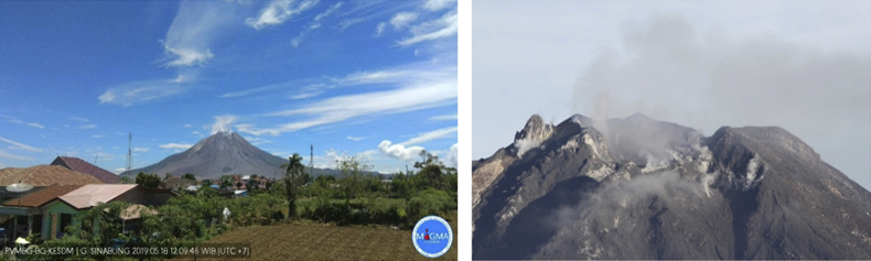 |
Figure 70. The summit of Sinabung emitted only steam and gas on 18 May 2019, shortly before PVMBG lowered the Alert Level from IV to III. Courtesy of PVMBG (Decreased G. Sinabung activity level from Level IV (Beware) to Level III (Standby), May 20, 2019). |
A large explosion was reported by the Darwin VAAC on 24 May 2019 (UTC) that produced a high-altitude ash plume visible in satellite imagery at 15.2 km altitude moving W; the plume was not visible from the ground due to fog. The Sinabung Volcano Observatory reported that the brief explosion lasted for only 7 minutes (figure 71), but the plume detached and drifted NW for about 12 hours before dissipating. The substantial SO2 plume associated with the event was recorded by satellite instruments a few hours later (figure 72, left). Another six-minute explosion late on 26 May (UTC) produced an ash plume that was reported by a ground observer at 4.9 km altitude drifting S (figure 72, right). About an hour after the event, the Darwin VAAC observed the plume drifting S at 6.1 km altitude; it had dissipated four hours later. Sumbul Sembiring, a resident of Kabanjahe, told news outlet Tempo.com that ash had fallen at the settlements. Two more explosions were reported on 27 May; the first lasted for a little over 12 minutes, the second (about 90 minutes later, 28 May local time) lasted for about 2.5 minutes. No ash plumes were visible from the ground or satellite imagery for either event.
 |
Figure 71. A brief but powerful explosion at Sinabung in the early hours of 25 May 2019 (local time) produced a seven-minute-long seismic signal and a 15.2-km-altitude ash plume. Courtesy of MAGMA Indonesia and Volcano Discovery. |
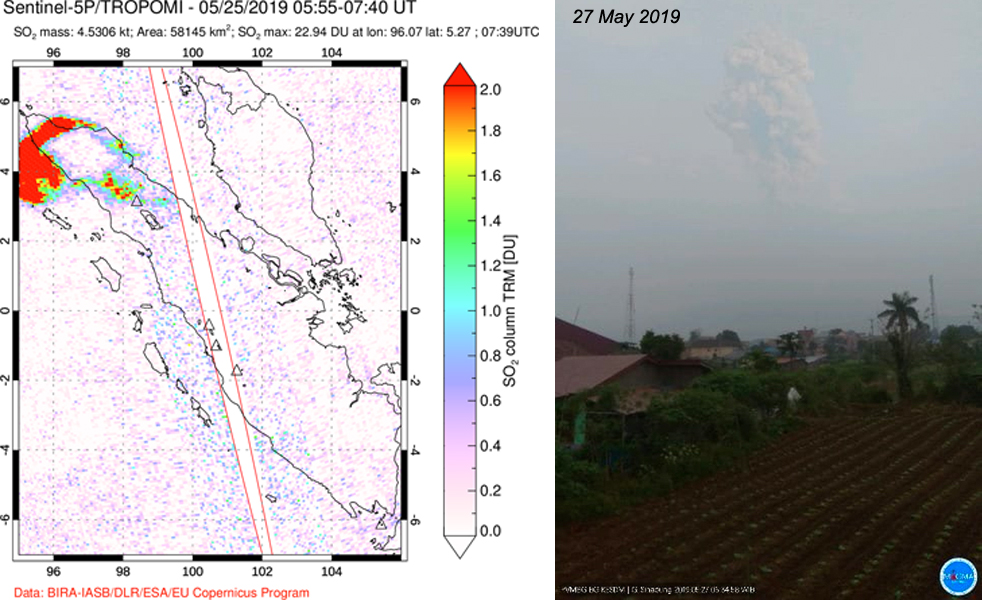 |
Figure 72. Two closely spaced eruptive events occurred at Sinabung on 24 and 26 May UTC (25 and 27 May local time). The 24 May event produced a significant SO2 plume recorded by the TROPOMI instrument a few hours afterwards (left), and a 15.2-km-altitude ash plume only recorded in satellite imagery. The event on 26 May produced a visible ash plume that was reported at 6.1 km altitude and was faintly visible from the ground (right). SO2 courtesy of NASA Goddard Space Flight Center, photograph courtesy of PVMBG and Øystein Lund Andersen. |
An explosion on 9 June 2019 produced an ash plume, estimated from the ground as rising to 9.5 km altitude, that drifted S and E; pyroclastic flows traveled 3.5 km SE and 3 km S down the flanks (figure 73). The explosion was heard at the Sinabung Observatory. The Darwin VAAC reported that the eruption was visible in Himawari-8 satellite imagery, and reported by pilots, at 16.8 km altitude drifting W; about an hour later the VAAC noted that the detached plume continued drifting SW but lower plumes were still present at 9.1 km altitude drifting W and below 4.3 km drifting SE. They also noted that pyroclastic flows moving SSE were sending ash to 4.3 km altitude. Three hours later they reported that both upper level plumes had detached and were moving SW and W. After six hours, the lower altitude plumes at 4.3 and 9.1 km altitudes had dissipated; the higher plume continued moving SW at 12.2 km altitude until it dissipated within the next eight hours. Instruments on the Sentinel-5P satellite captured an SO2 plume from the explosion drifting W across the southern Indian Ocean (figure 74).
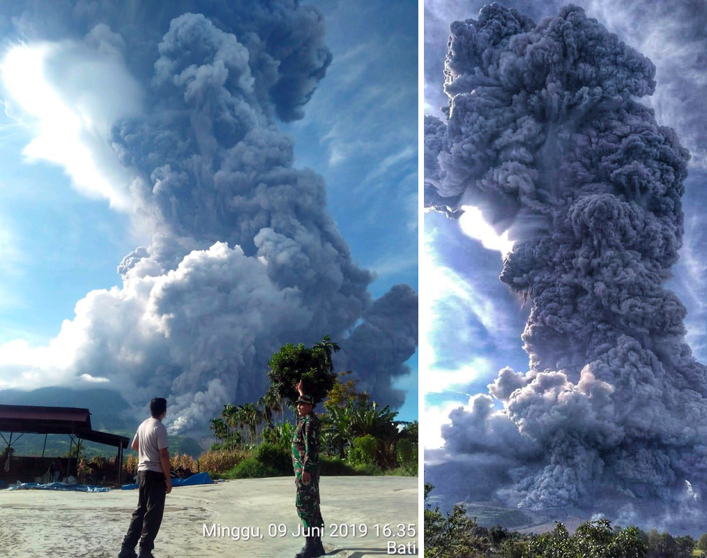 |
Figure 73. A large explosion at Sinabung on 9 June 2019 produced an ash plume that rose to 16.8 km altitude and also generated pyroclastic flows (foreground) that traveled down the S and SE flanks. Left image courtesy of Sutopo Purwo Nugroho, Head of the BNPB Information and Public Relations Data Center. Right image photo source PVMBG/Mbah Rono/ Berastagi Nachelle Homestay, courtesy of Jaime Sincioco. |
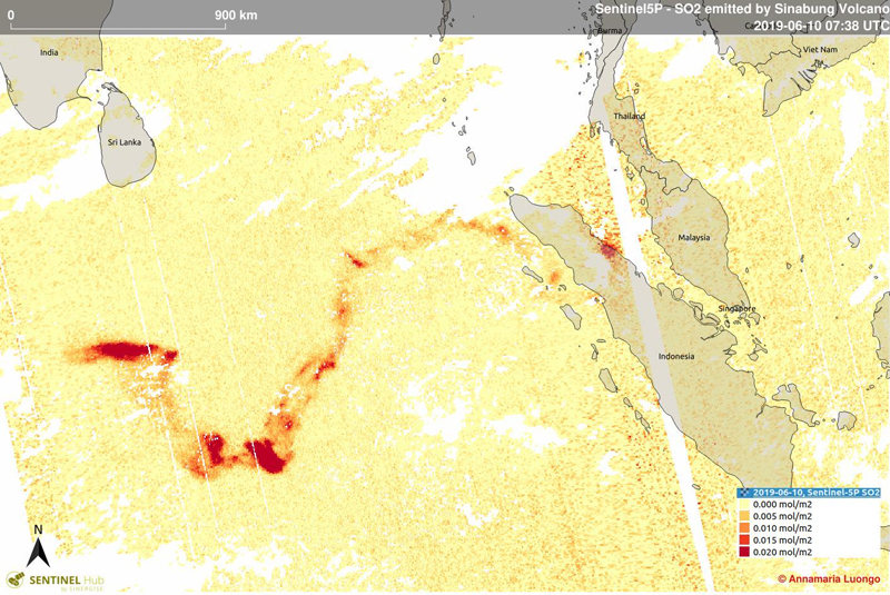 |
Figure 74. An SO2 plume from the 9 June 2019 explosion at Sinabung drifted more than a thousand kilometers W across the southern Indian Ocean. Courtesy of Sentinel Hub and Annamaria Luongo. |
The SVO reported continuous ash and gas emissions at 3.0 km altitude moving ESE early on 10 June; it was obscured in satellite imagery by meteoric clouds. There were no additional VONA's or VAAC reports issued for the remainder of June or July 2019. An image on social media from 20 June 2019 shows incandescent blocks near the summit (figure 75). PVMBG reported that emissions on 25 June were white to brownish and rose 200 m above the summit and drifted E and SE.
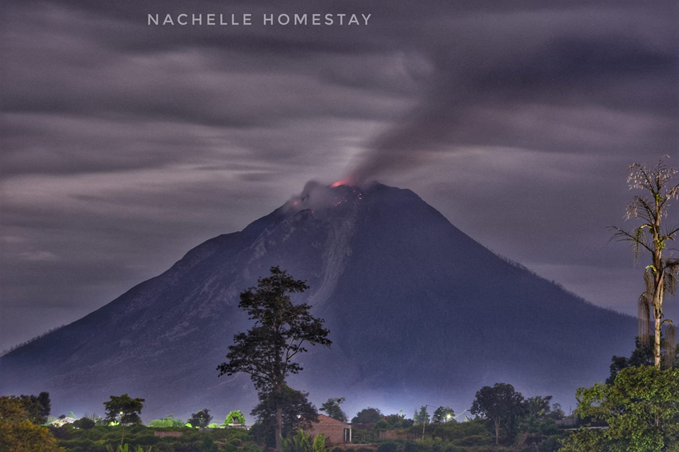 |
Figure 75. Incandescent blocks at the summit of Sinabung were visible in this 20 June 2019 image taken from a rooftop terrace in Berastagi, 13 km E. Photo by Nachelle Homestay, courtesy of Jaime Sincioco. |
PVMBG detected seismic signals from lahars several times during the second week of July 2019. News outlets reported lahars damaging villages in the Karo district on 11 and 13 July (figure 76). Detik.com reported that lahars cut off the main access road to Perbaji Village (4 km SW), Kutambaru Village (14 km S), and the Tiganderket connecting road to Kutabuluh (17 km WNW). In addition, Puskesmas Kutambaru was submerged in mud. Images from iNews Malam showed large boulders and rafts of trees in thick layers of mud covering homes and roads. No casualties were reported.
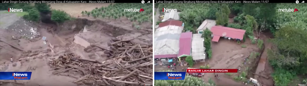 |
Figure 76. Lahars on 11 and 13 July 2019 caused damage in numerous villages around Sinabung, filling homes and roadways with mud, tree trunks, and debris. No casualties were reported. Courtesy of iNews Malam. |
Geological Summary. Gunung Sinabung is a Pleistocene-to-Holocene stratovolcano with many lava flows on its flanks. The migration of summit vents along a N-S line gives the summit crater complex an elongated form. The youngest crater of this conical andesitic-to-dacitic edifice is at the southern end of the four overlapping summit craters. The youngest deposit is a SE-flank pyroclastic flow 14C dated by Hendrasto et al. (2012) at 740-880 CE. An unconfirmed eruption was noted in 1881, and solfataric activity was seen at the summit and upper flanks in 1912. No confirmed historical eruptions were recorded prior to explosive eruptions during August-September 2010 that produced ash plumes to 5 km above the summit.
Information Contacts: Pusat Vulkanologi dan Mitigasi Bencana Geologi (PVMBG, also known as Indonesian Center for Volcanology and Geological Hazard Mitigation, CVGHM), Jalan Diponegoro 57, Bandung 40122, Indonesia (URL: http://www.vsi.esdm.go.id/); MAGMA Indonesia, Kementerian Energi dan Sumber Daya Mineral (URL: https://magma.vsi.esdm.go.id/); Darwin Volcanic Ash Advisory Centre (VAAC), Bureau of Meteorology, Northern Territory Regional Office, PO Box 40050, Casuarina, NT 0811, Australia (URL: http://www.bom.gov.au/info/vaac/); Global Sulfur Dioxide Monitoring Page, Atmospheric Chemistry and Dynamics Laboratory, NASA Goddard Space Flight Center (NASA/GSFC), 8800 Greenbelt Road, Goddard, Maryland, USA (URL: https://so2.gsfc.nasa.gov/); The Jakarta Post (URL: https://www.thejakartapost.com/news/2019/05/07/mount-sinabung-erupts-again.html); Detikcom (URL: https://news.detik.com/berita/d-4619253/hujan-deras-sejumlah-desa-di-sekitar-gunung-sinabung-banjir-lahar-dingin); iNews Malam (URL: https://tv.inews.id/, https://www.youtube.com/watch?v=uAI4CpSb41k); Tempo.com (URL:https://en.tempo.co/read/1209667/mount-sinabung-erupts-on-monday-morning); David de Zabedrosky, Calera de Tango, Chile (Twitter: @deZabedrosky, URL: https://twitter.com/deZabedrosky/status/1125814504867160065/photo/1, https://twitter.com/deZabedrosky/status/1125814504867160065/photo/2); Sutopo Purwo Nugroho, BNPB (Twitter: @Sutopo_PN, URL: https://twitter.com/Sutopo_PN); Tom Pfeiffer, Volcano Discovery (URL: http://www.volcanodiscovery.com/); Øystein Lund Andersen? (Twitter: @OysteinLAnderse, URL: https://twitter.com/OysteinLAnderse, URL: http://www.oysteinlundandersen.com image at https://twitter.com/OysteinLAnderse/status/1132849458142572544); Jaime Sincioco, Phillipines (Twitter: @jaimessincioca, URL: https://twitter.com/jaimessincioco); Annamaria Luongo, University of Padua, Venice, Italy (Twitter: @annamaria_84, URL:https://twitter.com/annamaria_84).