Report on Semeru (Indonesia) — September 2019

Bulletin of the Global Volcanism Network, vol. 44, no. 9 (September 2019)
Managing Editor: Edward Venzke.
Research and preparation by Paul Berger.
Semeru (Indonesia) Intermittent activity continues during March-August 2019; ash plumes and thermal anomalies
Please cite this report as:
Global Volcanism Program, 2019. Report on Semeru (Indonesia) (Venzke, E., ed.). Bulletin of the Global Volcanism Network, 44:9. Smithsonian Institution. https://doi.org/10.5479/si.GVP.BGVN201909-263300
Semeru
Indonesia
8.108°S, 112.922°E; summit elev. 3657 m
All times are local (unless otherwise noted)
The ongoing eruption at Semeru weakened in intensity during 2018, with occasional ash plumes and thermal anomalies (BGVN 44:04); this reduced but ongoing level of activity continued through August 2019. The volcano is monitored by the Pusat Vulkanologi dan Mitigasi Bencana Geologi (PVMBG, also known as Indonesian Center for Volcanology and Geological Hazard Mitigation, CVGHM) and the Darwin Volcanic Ash Advisory Centre (VAAC). The current report summarizes activity from 1 March to 31 August 2019. The Alert Level remained at 2 (on a scale from 1-4); the public was warned to stay 1 km away from the active crater and 4 km away on the SSE flank.
Based on analysis of satellite images, the Darwin VAAC reported that ash plumes rose to an altitude of 4-4.3 km on 19 April, 20 June, 10 July, and 13 July, drifting in various directions. In addition, PVMBG reported that at 0830 on 26 June an explosion produced an ash plume that rose around 600 m above the summit and drifted SW. A news article (Tempo.com) dated 12 August cited PVMBG as stating that the volcano had erupted 17 times since 8 August.
During March-August 2019 thermal anomalies were detected with the MODIS satellite instruments analyzed using the MODVOLC algorithm only on 5 July and 22 August. No explosions were recorded on those two days. Scattered thermal anomalies within 5 km of the volcano were detected by the MIROVA (Middle InfraRed Observation of Volcanic Activity) system, also based on analysis of MODIS data: one at the end of March and 3-6 hotspots over the following months, almost all of low radiative power. Satellite imagery intermittently showed thermal activity in the Jonggring-Seloko crater (figure 37), sometimes with material moving down the SE-flank ravine.
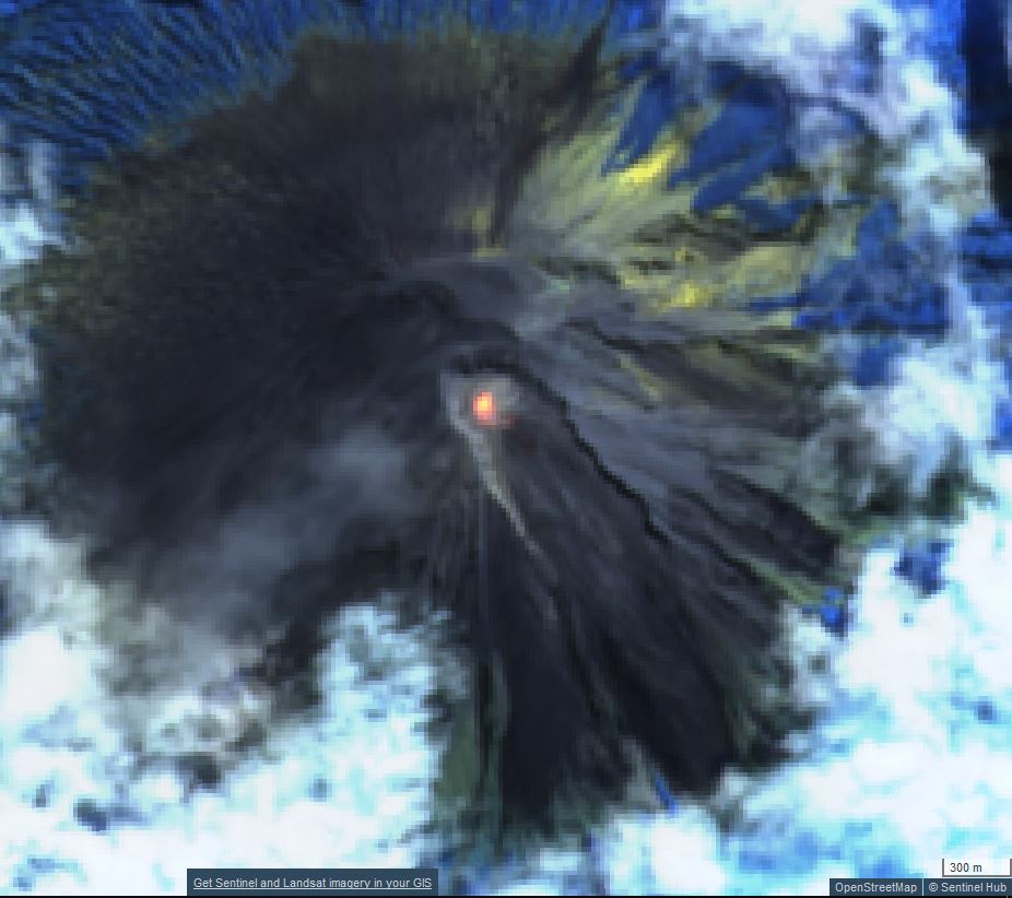 |
Figure 37. Sentinel-2 satellite images showing the persistent elevated thermal anomaly in the Jonggring-Seloko crater of Semeru were common through August 2019, as seen in this view on 20 July. Hot material could sometimes be identified in the SE-flank ravine. Atmospheric penetration rendering (bands 12, 11, 8A) courtesy of Sentinel Hub Playground. |
Geological Summary. Semeru, the highest volcano on Java, and one of its most active, lies at the southern end of a volcanic massif extending north to the Tengger caldera. The steep-sided volcano, also referred to as Mahameru (Great Mountain), rises above coastal plains to the south. Gunung Semeru was constructed south of the overlapping Ajek-ajek and Jambangan calderas. A line of lake-filled maars was constructed along a N-S trend cutting through the summit, and cinder cones and lava domes occupy the eastern and NE flanks. Summit topography is complicated by the shifting of craters from NW to SE. Frequent 19th and 20th century eruptions were dominated by small-to-moderate explosions from the summit crater, with occasional lava flows and larger explosive eruptions accompanied by pyroclastic flows that have reached the lower flanks of the volcano.
Information Contacts: Pusat Vulkanologi dan Mitigasi Bencana Geologi (PVMBG, also known as Indonesian Center for Volcanology and Geological Hazard Mitigation, CVGHM), Jalan Diponegoro 57, Bandung 40122, Indonesia (URL: http://www.vsi.esdm.go.id/); Darwin Volcanic Ash Advisory Centre (VAAC), Bureau of Meteorology, Northern Territory Regional Office, PO Box 40050, Casuarina, NT 0811, Australia (URL: http://www.bom.gov.au/info/vaac/); MIROVA (Middle InfraRed Observation of Volcanic Activity), a collaborative project between the Universities of Turin and Florence (Italy) supported by the Centre for Volcanic Risk of the Italian Civil Protection Department (URL: http://www.mirovaweb.it/); Hawai'i Institute of Geophysics and Planetology (HIGP) - MODVOLC Thermal Alerts System, School of Ocean and Earth Science and Technology (SOEST), Univ. of Hawai'i, 2525 Correa Road, Honolulu, HI 96822, USA (URL: http://modis.higp.hawaii.edu/); Sentinel Hub Playground (URL: https://www.sentinel-hub.com/explore/sentinel-playground); Tempo.com (URL: https://www.tempo.com/).