Report on Santa Maria (Guatemala) — September 2019

Bulletin of the Global Volcanism Network, vol. 44, no. 9 (September 2019)
Managing Editor: Edward Venzke.
Edited by A. Elizabeth Crafford.
Santa Maria (Guatemala) Persistent explosions with local ashfall, March-August 2019; frequent lahars during June; increased explosions in early July
Please cite this report as:
Global Volcanism Program, 2019. Report on Santa Maria (Guatemala) (Crafford, A.E., and Venzke, E., eds.). Bulletin of the Global Volcanism Network, 44:9. Smithsonian Institution. https://doi.org/10.5479/si.GVP.BGVN201909-342030
Santa Maria
Guatemala
14.757°N, 91.552°W; summit elev. 3745 m
All times are local (unless otherwise noted)
The dacitic Santiaguito lava-dome complex on the W flank of Guatemala's Santa María volcano has been growing and actively erupting since 1922. The youngest of the four vents in the complex, Caliente, has been erupting with ash explosions, pyroclastic, and lava flows for more than 40 years. A lava dome that appeared within the summit crater of Caliente in October 2016 has continued to grow, producing frequent block avalanches down the flanks. Daily explosions of steam and ash also continued during March-August 2019, the period covered in this report, with information primarily from Guatemala's INSIVUMEH (Instituto Nacional de Sismologia, Vulcanologia, Meterologia e Hidrologia) and the Washington VAAC (Volcanic Ash Advisory Center).
Activity at Santa Maria continued with little variation from previous months during March-August 2019, except for a short-lived increase in the frequency and intensity of explosions during early July that produced minor pyroclastic flows. Plumes of steam with minor magmatic gases rose continuously from both the S rim of the Caliente crater and from the summit of the growing dome throughout the period. They usually rose 100-700 m above the summit, generally drifting W or SW, and occasionally SE, before dissipating. In addition, daily explosions with varying amounts of ash rose to altitudes of around 2.8-3.5 km and usually extended no more than 25 km before dissipating. Most of the plumes drifted SW or SE; minor ashfall occurred in the adjacent hills almost daily and was reported at the fincas located within 10 km in those directions several times each month. Continued growth of the Caliente lava dome resulted in daily block avalanches descending its flanks to the base of the dome. The MIROVA plot of thermal energy during this time shows a consistent level of heat from early December 2018 through April 2019, very little activity during May and June, and a short-lived spike in activity from late June through early July that coincides with the increase in explosion rate and intensity. Activity decreased later in July and into August (figure 95).
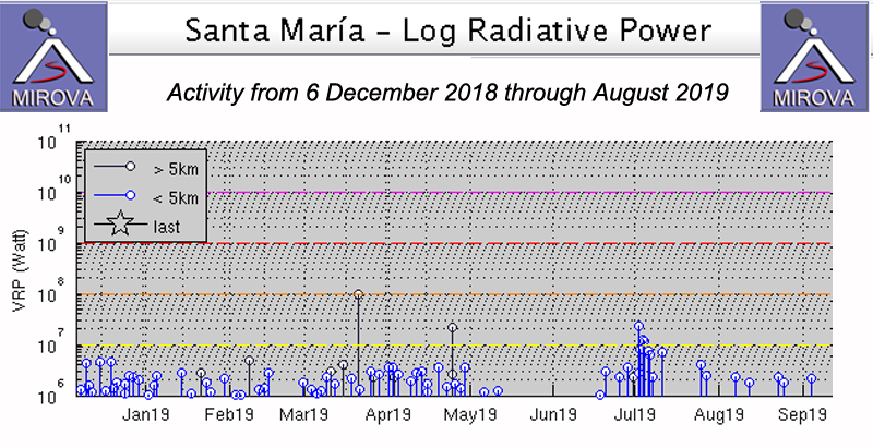 |
Figure 95. Thermal activity at Santa Maria from 8 December 2018 through August 2019 was similar to previous months. A noticeable decrease in activity occurred during May and early June 2019 with a short-lived spike during late June and early July that corresponded to an increase in explosion rate and intensity during that brief interval. Courtesy of MIROVA. |
Explosive activity increased slightly during March 2019 to 474 events from 409 events during February, averaging about 15 per day; the majority of explosions were weak to moderate in strength. The moderate explosions generated small block avalanches daily that sent debris 300 m down the flanks of Caliente dome; the explosions contained low levels of ash and large quantities of steam. Daily activity consisted mostly of degassing around the southern rim of the crater and within the central dome, with plumes rising about 100 m from the S rim, and pulsating between 100-400 m above the central dome, usually white and sometimes blue with gases; steam plumes drifted as far as 10 km. The weak ash emissions resulted in ashfall close to the volcano, primarily to the W and SW in the mountainous areas of El Faro, Patzulín, La Florida, and Monte Bello farms. During mid-March, residents of the villages of Las Marías and El Viejo Palmar, located S of the dome, reported the smell of sulfur. The seismic station STG3 registered 8-23 explosions daily that produced ash plumes which rose to altitudes between 2.7 and 3.3 km altitude. Explosions from the S rim were usually steam rich, while reddish oxidized ash was more common from the NE edge of the growing dome in the summit crater (figure 96). The constant block avalanches were generated by viscous lava slowly emerging from the growing summit dome, and also from the explosive activity. On the steep S flank of Santa Maria, blocks up to 3 m in diameter often produce small plumes of ash and debris as they fall.
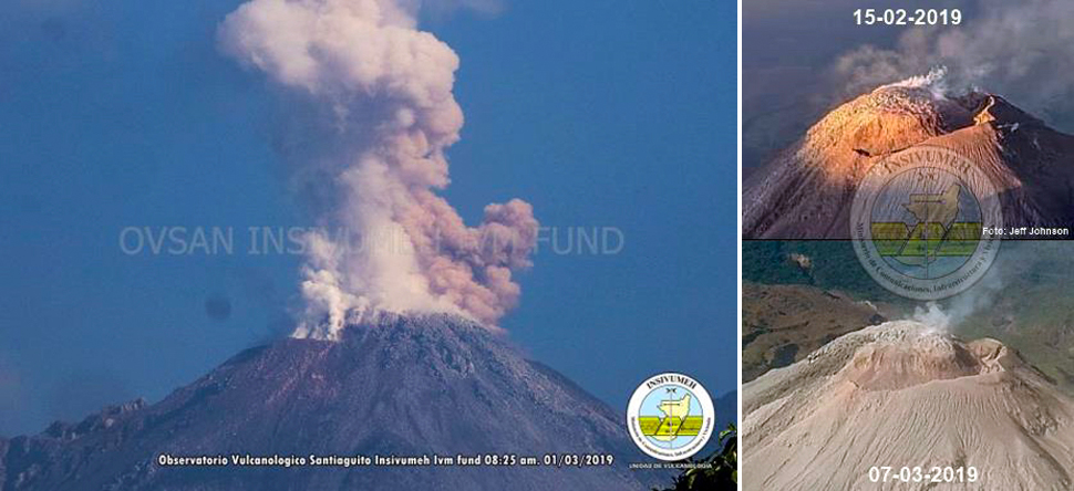 |
Figure 96. Mostly steam rose from the S rim of the Caliente dome at Santa Maria throughout March-August 2019. On 1 March 2019, oxidized reddish ash from the growing dome was also part of the emissions (left). The dome continued to grow, essentially filling the inside of the summit crater of Caliente. Courtesy of INSIVUMEH (INFORME MENSUAL DE ACTIVIDAD VOLCÁNICA MARZO 2019, VOLCÁN SANTIAGUITO). |
Late on 4 March 2019 an explosion was heard 10 km away that generated incandescence 100 m above the crater and block avalanches that descended to the base of the Caliente dome; it also resulted in ashfall around the perimeter of the volcano. Powerful block avalanches were reported in Santa María creek on 8 March. Ashfall was reported in the villages of San Marcos and Loma Linda Palajunoj on 14 March. Ash plumes on 18 March drifted W and caused ashfall in the villages of Santa María de Jesús and Calaguache. A small amount of ashfall was reported on 26 March around San Marcos Palajunoj. The Washington VAAC reported volcanic ash drifting W from the summit on 8 March at 4.6 km altitude. A small ash plume was visible in satellite imagery moving WSW on 11 March at 4.6 km altitude. On 20 March a plume was detected drifting SW at 3.9 km altitude for a short time before dissipating.
Explosion rates of 10-14 per day were typical for April 2019. Ash plumes rose to 2.7-3.2 km altitude. Block avalanches reached the base of the Caliente dome each day. Steam and gas plumes pulsated 100-400 m above the S rim of the crater (figure 97). Ashfall in the immediate vicinity of the volcano, generally on the W and SW flanks was also a daily feature. The Washington VAAC reported multiple small ash emissions on 2 April moving W and dissipating quickly at 4.9 km altitude. An ash plume from two emissions drifted WSW at 4.3 km altitude on 10 April, and on 22 April two small discrete emissions were observed in satellite images moving SE at 4.6 km altitude. Ashfall was reported on 13 and 14 April in the nearby mountains and areas around Finca San José to the SE. On 15 and 23 April, ash plumes drifted W and ashfall was reported in the area of San Marcos and Loma Lina Palajunoj.
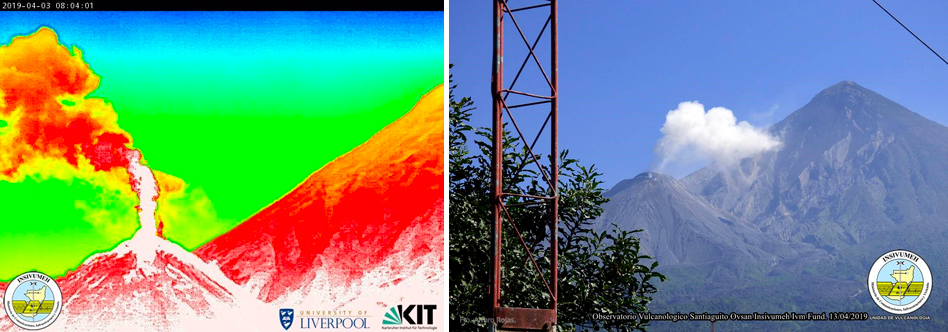 |
Figure 97. Degassing from the Caliente dome at Santa Maria on 3 April (left, infrared image) and 13 April 2019 (right) produced steam-rich plumes with minor quantities of ash. Courtesy of INSIVUMEH (Reporte Semanal de Monitoreo:, Volcán Santiaguito, Semana del 30 de marzo al 05 de abril de 2019). |
Constant degassing continued from the S rim of the crater during May 2019 while pulses of steam and gas rose 100-500 m from the dome at the center of the summit crater. Weak to moderate explosions continued at a rate of 8-12 per day. White and gray plumes of steam and ash rose 300-700 m above the crater daily. A moderate-size lahar on 16 May descended the Rio San Isisdro; it was 20 m wide and carried blocks 2 m in diameter. Ashfall was reported on the W flank around the area of San Marcos and Loma Lina Palajunoj on 21 and 24 May. INSIVIUMEH reported on 29 and 30 May that seismic station STG8 recorded moderate lahars descending the Rio San Isidro (a drainage to the Rio Tambor). The thick, pasty lahars transported blocks 1-3 m in diameter, branches, and tree trunks. They were 20 m wide and 1.5-2 m deep.
Weak to moderate explosions continued during June 2019 at a rate of 9-12 per day, producing plumes of ash and steam that rose 300-700 m above the Caliente crater. On 1 June explosions produced ashfall to the E over the areas of Calaguache, Las Marías and other nearby communities. Ash plumes commonly reached 3.0-3.3 km altitude and drifted W and SW, and block avalanches constantly descended the E and SE flanks from the dome at the top of Caliente. Ashfall was reported at the Santa María de Jesús community on 7 June. Ashfall to the W in San Marcos and Loma Linda Palajunoj was reported on 10, 15, 18, 20, and 22 June. Ashfall to the SE in Fincas Monte Claro and El Patrocinio was reported on 26 June. A few of the explosions on 28 June were heard up to 10 km away. On 29 June ash dispersed to the W again over the farms of San Marcos, Monte Claro, and El Patrocinio in the area of Palajunoj; the next day, ash was reported in Loma Linda and finca Monte Bello to the SW. The Washington VAAC reported ash emissions on 29 June that rose to 4.3 km and drifted W; two ash clouds were observed, one was 35 km from Santa Maria and the second drifted 55 km before dissipating.
With the onset of the rainy season, eight lahars were reported during June. The Rio Cabello de Ángel, a tributary of Río Nimá I (which flows into Rio Samalá) on the SE flank experienced lahars on 3, 5, 11, 12, 21, and 30 June (figure 98). The lahars were 15-20 m wide, 1-2 m deep, and carried branches, tree trunks and blocks 1-3 m in diameter. On 12 and 15 June, lahars descended the Río San Isidro on the SW flank. They were 1.5 m deep, 15-20 m wide and carried tree trunks and blocks up to 2 m in diameter.
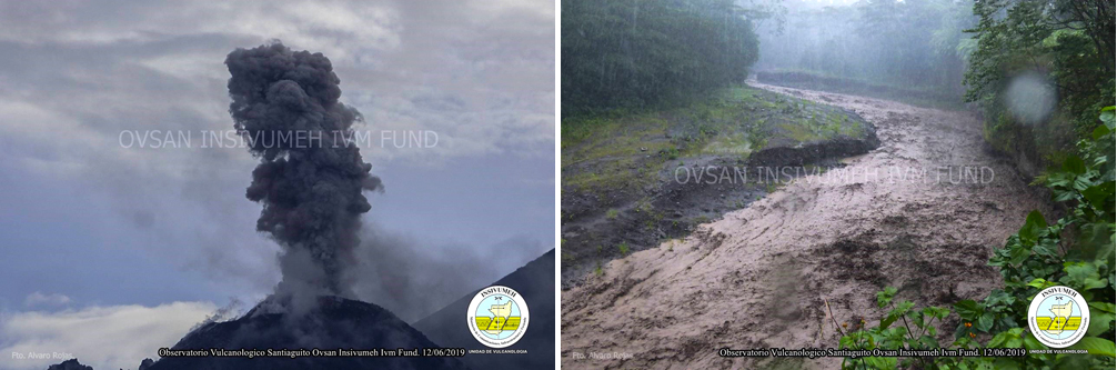 |
Figure 98. Activity at Santa Maria on 12 June 2019 included explosions with abundant ash and lahars. This lahar is in the Rio Nimá I, and started in the Rio Cabello de Ángel. Courtesy of INSIVUMEH (Reporte Semanal de Monitoreo: Volcán Santiaguito, Semana del 08 al 14 de junio de 2019). |
An increase in the frequency and intensity of seismic events was noted beginning on 28 June that lasted through 6 July 2019. Explosions occurred at a rate of 5-6 per hour, reaching 40-45 events per day instead of the 12-15 typical of previous months. Ash plumes rose to 3.5-3.8 km altitude and drifted W, SW, and S as far as 10 km, and ashfall was reported in San Marcos Palajunoj, Loma Linda villages, Monte Bello farms, El Faro, La Mosqueta, La Florida, and Monte Claro. Activity decreased after 7 July back to similar levels of the previous months. As a result of the increased activity during the first week of July, several small pyroclastic flows (also known as pyroclastic density currents or PDC's) were generated that traveled up to 1 km down the S, SE, and E flanks during 2-5 and 13 July, in addition to the constant block avalanches from the dome extrusion and explosions (figure 99). As activity levels decreased after 6 July, the ash plume heights lowered to 3.3 km altitude, while pulsating degassing continued from the summit dome, rising 100-500 m.
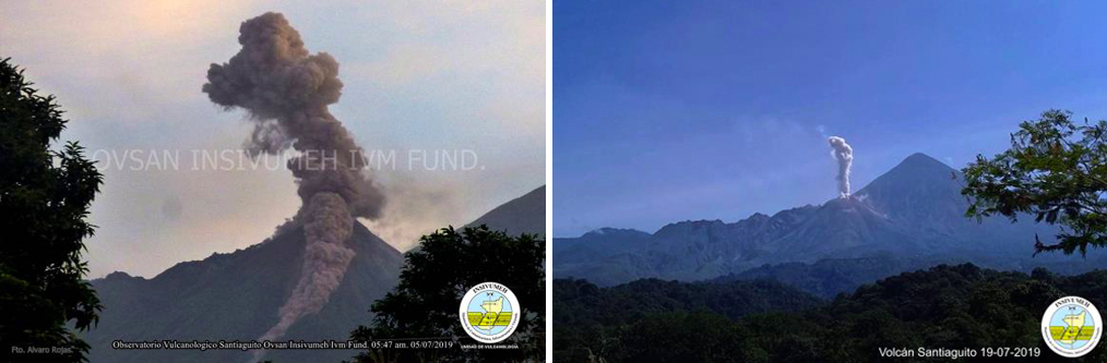 |
Figure 99. An increase in explosive activity at Santa Maria during the first week of July 2019 resulted in several small pyroclastic flows descending the flanks, including one on 3 July 2019 (left). An ash emission on 19 July 2019 rose above the nearby summit of Santa Maria (right). Courtesy of INSIVUMEH (INFORME MENSUAL DE ACTIVIDAD VOLCÁNICA JULIO 2019, VOLCÁN SANTIAGUITO). |
The Washington VAAC reported an ash plume on 2 July from a series of emissions that rose to 3.9 km altitude and drifted W. Satellite imagery on 4 July showed a puff of ash moving W from the summit at 4.3 km altitude. The next day an ash emission was observed in satellite imagery moving W at 4.9 km altitude. A plume on 11 July drifted W at 4.3 km for several hours before dissipating. Ashfall was reported on 2 July at the San Marcos farm and in the villages of Monte Claro and El Patrocinio in the Palajunoj area. On 4 and 6 July ash fell to the SW and W in San Marcos and Loma Linda Palajunoj. On 5 July there were reports of ashfall in Monte Claro and areas around San Marcos Palajunoj and some explosions were heard 5 km away. In Monte Claro to the SW ash fell on 7 July and sounds were heard 5 km away every three minutes. Incandescence was observed in the early morning on the SE and NE flanks of the dome. During 8 and 9 July, four to eight weak explosions per hour were noted and ash dispersed SW, especially over Monte Claro; pulsating degassing noises were heard every two minutes. Monte Bello and Loma Linda reported ashfall on 12, 16, 17, 19, and 20 July. On 15, 22, 26, and 29 July ash was reported in San Marcos and Loma Linda Palajunoj; 33 explosions occurred on 25 July. Two lahars were reported on 8 July. A strong one in the Rio San Isidro was more than 2 m deep, and 20-25 m wide with blocks as large as 3 m in diameter. A more moderate lahar affected Rio Cabello de Angel and was also 2 m deep. It was 15-20 m wide and had blocks 1-2 m in diameter.
Activity declined further during August 2019. Constant degassing continued from the S rim of the crater, but only occasional pulses of steam and gas rose from the central dome. Weak to moderate explosions occurred at a rate of 15-20 per day. White and gray plumes with small amounts of ash rose 300-800 m above the summit daily. Block avalanches descended to the base of the dome and sent fine ash particles down the SE and S flanks. Ashfall was common within 5 km of the summit, generally on the SW flank, near Monte Bello farm, Loma Linda village and San Marcos Palajunoj. Explosions rates decreased to 10-11 per day during the last week of the month. Degassing and ash plumes rose to 2.9-3.2 km altitude throughout the month.
On 1 August ash plumes drifted 10-15 km SW, causing ashfall in that direction. On 3 and 27 August ashfall occurred at Monte Claro and El Patrocinio in the Palajunoj area to the SW. On 7 and 31 August ashfall was reported in Monte Claro. San Marcos and Loma Linda Palajunoj reported ash on 11, 16, 19, and 23 August. On 21 August ashfall was reported to the SE around Finca San José. The Washington VAAC reported an ash plume visible in satellite imagery on 10 August 2019 drifting W at 4.3 km altitude a few kilometers from the summit which dissipated quickly. On 27 August a plume was observed 25 km W of the summit at 3.9 km altitude, dissipating rapidly. On 3 August a moderate lahar descended the Rio Cabello de Ángel that was 1 m deep, 15 m wide and carried blocks up to 1 m in diameter along with branches and tree trunks. A large lahar on 20 August descended Río Cabello de Ángel; it was 2-3 m high, 15 m wide and carried blocks 1-2 m diameter, causing erosion along the flanks of the drainage (figure 100).
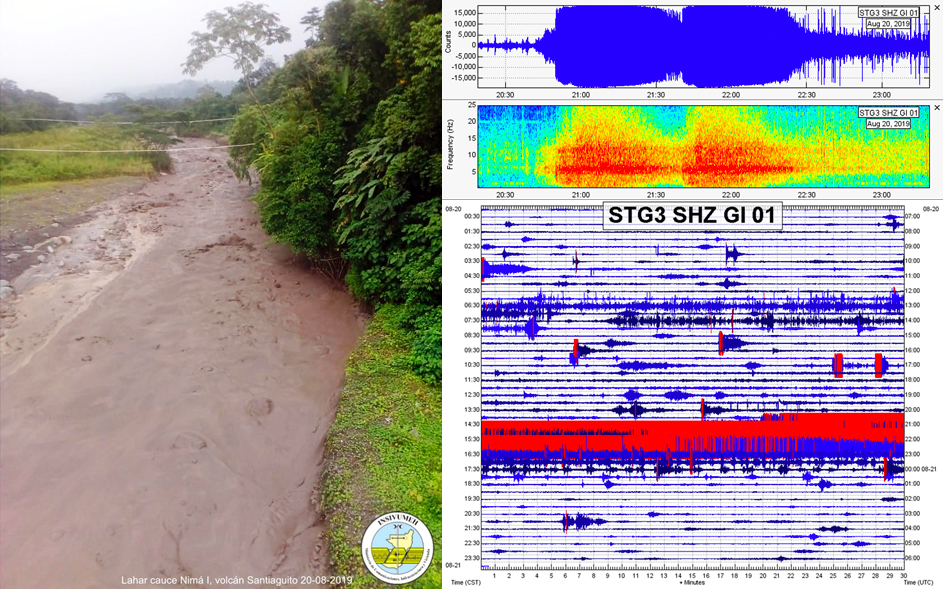 |
Figure 100. A substantial lahar at Santa Maria on 20 August 2019 sent debris down the Río Cabello de Ángel in the vicinity of El Viejo Palmar (left), the spectrogram of the seismic signal lasted for 2 hours and 16 minutes (top right), and the seismograph was saturated with the lahar signal in red (bottom right). Courtesy of INSIVUMEH (Reporte Semanal de Monitoreo: Volcán Santiaguito, Semana del 17 al 23 de agosto de 2019). |
Geological Summary. Symmetrical, forest-covered Santa María volcano is part of a chain of large stratovolcanoes that rise above the Pacific coastal plain of Guatemala. The sharp-topped, conical profile is cut on the SW flank by a 1.5-km-wide crater. The oval-shaped crater extends from just below the summit to the lower flank, and was formed during a catastrophic eruption in 1902. The renowned Plinian eruption of 1902 that devastated much of SW Guatemala followed a long repose period after construction of the large basaltic andesite stratovolcano. The massive dacitic Santiaguito lava-dome complex has been growing at the base of the 1902 crater since 1922. Compound dome growth at Santiaguito has occurred episodically from four vents, with activity progressing E towards the most recent, Caliente. Dome growth has been accompanied by almost continuous minor explosions, with periodic lava extrusion, larger explosions, pyroclastic flows, and lahars.
Information Contacts: Instituto Nacional de Sismologia, Vulcanologia, Meteorologia e Hydrologia (INSIVUMEH), Unit of Volcanology, Geologic Department of Investigation and Services, 7a Av. 14-57, Zona 13, Guatemala City, Guatemala (URL: http://www.insivumeh.gob.gt/); MIROVA (Middle InfraRed Observation of Volcanic Activity), a collaborative project between the Universities of Turin and Florence (Italy) supported by the Centre for Volcanic Risk of the Italian Civil Protection Department (URL: http://www.mirovaweb.it/); Washington Volcanic Ash Advisory Center (VAAC), Satellite Analysis Branch (SAB), NOAA/NESDIS OSPO, NOAA Science Center Room 401, 5200 Auth Rd, Camp Springs, MD 20746, USA (URL: www.ospo.noaa.gov/Products/atmosphere/vaac, archive at: http://www.ssd.noaa.gov/VAAC/archive.html).