Report on Ulawun (Papua New Guinea) — December 2019

Bulletin of the Global Volcanism Network, vol. 44, no. 12 (December 2019)
Managing Editor: Edward Venzke.
Edited by Kadie L. Bennis.
Ulawun (Papua New Guinea) New vent, lava fountaining, lava flow, and ash plumes in late September-October 2019
Please cite this report as:
Global Volcanism Program, 2019. Report on Ulawun (Papua New Guinea) (Bennis, K.L., and Venzke, E., eds.). Bulletin of the Global Volcanism Network, 44:12. Smithsonian Institution. https://doi.org/10.5479/si.GVP.BGVN201912-252120
Ulawun
Papua New Guinea
5.05°S, 151.33°E; summit elev. 2334 m
All times are local (unless otherwise noted)
Ulawun is a basaltic-to-andesitic stratovolcano located in West New Britain, Papua New Guinea, with typical activity consisting of seismicity, gas-and-steam plumes, and ash emissions. The most recent eruption began in late June 2019 involving ash and gas-and-steam emissions, increased seismicity, and a pyroclastic flow (BGVN 44:09). This report includes volcanism from September to October 2019 with primary source information from the Rabaul Volcano Observatory (RVO) and the Darwin Volcanic Ash Advisory Centre (VAAC).
Activity remained low through 26 September 2019, mainly consisting of variable amounts of gas-and-steam emissions and low seismicity. Between 26 and 29 September RVO reported that the seismicity increased slightly and included low-level volcanic tremors and Real-Time Seismic Amplitude Measurement (RSAM) values in the 200-400 range on 19, 20, and 22 September. On 30 September small volcanic earthquakes began around 1000 and continued to increase in frequency; by 1220, they were characterized as a seismic swarm. The Darwin VAAC advisory noted that an ash plume rose to 4.6-6 km altitude, drifting SW and W, based on ground reports.
On 1 October 2019 the seismicity increased, reaching RSAM values up to 10,000 units between 0130 and 0200, according to RVO. These events preceded an eruption which originated from a new vent that opened on the SW flank at 700 m elevation, about three-quarters of the way down the flank from the summit. The eruption started between 0430 and 0500 and was defined by incandescence and lava fountaining to less than 100 m. In addition to lava fountaining, light- to dark-gray ash plumes were visible rising several kilometers above the vent and drifting NW and W (figure 21). On 2 October, as the lava fountaining continued, ash-and-steam plumes rose to variable heights between 2 and 5.2 km (figures 22 and 23), resulting in ashfall to the W in Navo. Seismicity remained high, with RSAM values passing 12,000. A lava flow also emerged during the night which traveled 1-2 km NW. The main summit crater produced white gas-and-steam emissions, but no incandescence or other signs of activity were observed.
 |
Figure 21. Photographs of incandescence and lava fountaining from Ulawun during 1-2 October 2019. A) Lava fountains along with ash plumes that rose several kilometers above the vent. B) Incandescence and lava fountaining seen from offshore. Courtesy of Christopher Lagisa. |
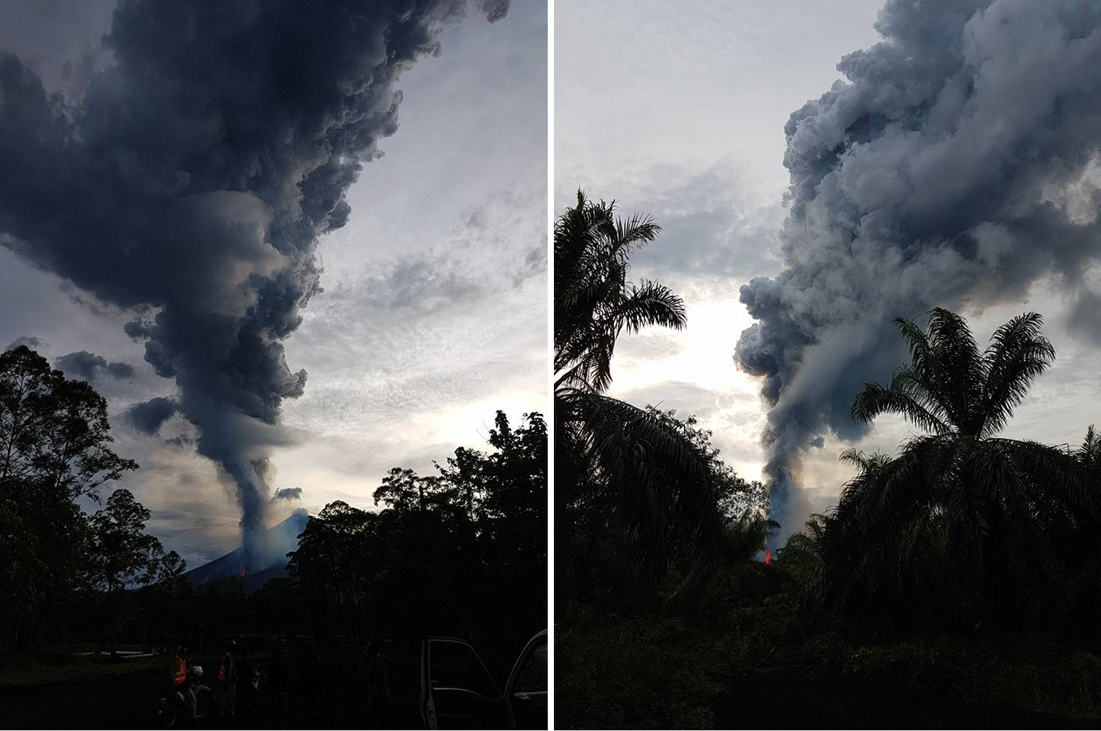 |
Figure 22. Photographs of an ash plume rising from Ulawun on 1 October 2019. In the right photo, lava fountaining is visible. Courtesy of Christopher Lagisa. |
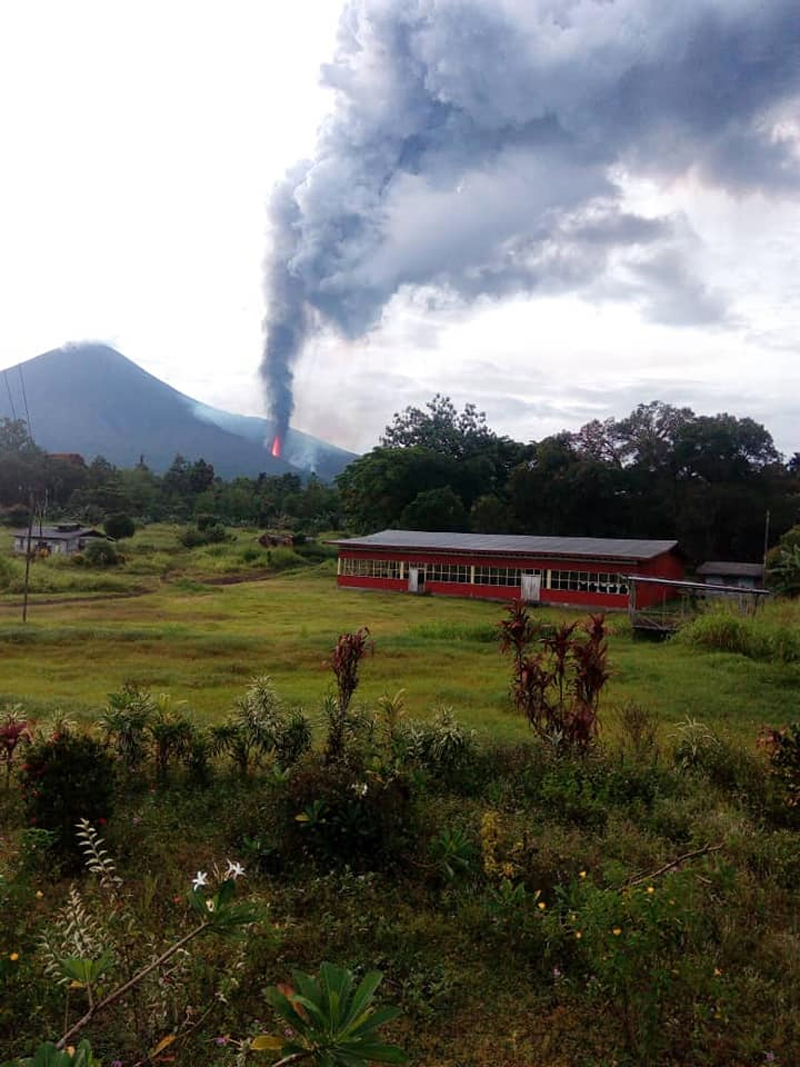 |
Figure 23. Photograph of lava fountaining and an ash plume rising from Ulawun on 1 October 2019. Courtesy of Joe Metto, WNB Provincial Disaster Office (RVO Report 2019100101). |
Ash emissions began to decrease by 3 October 2019; satellite imagery and ground observations showed an ash cloud rising to 3 km altitude and drifting N, according to the Darwin VAAC report. RVO reported that the fissure eruption on the SW flank stopped on 4 October, but gas-and-steam emissions and weak incandescence were still visible. The lava flow slowed, advancing 3-5 m/day, while declining seismicity was reflected in RSAM values fluctuating around 1,000. RVO reported that between 23 and 31 October the main summit crater continued to produce variable amounts of white gas-and-steam emissions (figure 24) and that no incandescence was observed after 5 October. Gas-and-steam emissions were also observed around the new SW vent and along the lava flow. Seismicity remained low until 27-29 October; it increased again and peaked on 30 October, reaching an RSAM value of 1,700 before dropping and fluctuating around 1,200-1,500.
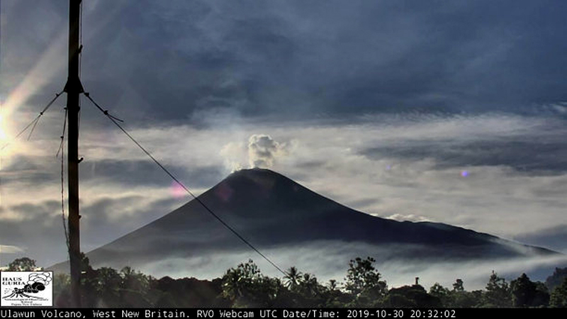 |
Figure 24. Webcam photo of a gas-and-steam plume rising from Ulawun on 30 October 2019. Courtesy of the Rabaul Volcano Observatory (RVO). |
In addition to ash plumes, SO2 plumes were also detected between September and October 2019. Sentinel-5P/TROPOMI data showed SO2 plumes, some of which exceeded 2 Dobson Units (DU) drifting in different directions (figure 25). MIROVA (Middle InfraRed Observation of Volcanic Activity) analysis of MODIS satellite data showed strong, frequent thermal anomalies within 5 km of the summit beginning in early October 2019 and throughout the rest of the month (figure 26). Only one thermal anomaly was detected in early December.
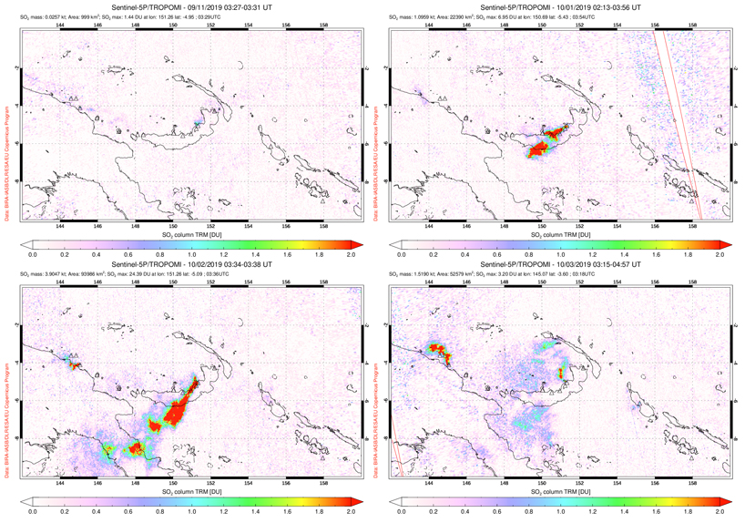 |
Figure 25. Sentinel-5P/TROPOMI data showing a high concentration of SO2 plumes rising from Ulawun between late September-early October 2019. Top left: 11 September 2019. Top right: 1 October 2019. Bottom left: 2 October 2019. Bottom right: 3 October 2019. Courtesy of the NASA Space Goddard Flight Center. |
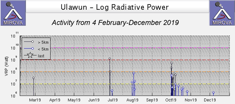 |
Figure 26. Frequent and strong thermal anomalies at Ulawun for February through December 2019 as recorded by the MIROVA system (Log Radiative Power) began in early October and continued throughout the month. Courtesy of MIROVA. |
Activity in November was relatively low, with only a variable amount of white gas-and-steam emissions visible and low (less than 200 RSAM units) seismicity with sporadic volcanic earthquakes. Between 9-22 December, a webcam showed intermittent white gas-and-steam emissions were observed at the main crater, accompanied by some incandescence at night. Some gas-and-steam emissions were also observed rising from the new SW vent along the lava flow.
Geological Summary. The symmetrical basaltic-to-andesitic Ulawun stratovolcano is the highest volcano of the Bismarck arc, and one of Papua New Guinea's most frequently active. The volcano, also known as the Father, rises above the N coast of the island of New Britain across a low saddle NE of Bamus volcano, the South Son. The upper 1,000 m is unvegetated. A prominent E-W escarpment on the south may be the result of large-scale slumping. Satellitic cones occupy the NW and E flanks. A steep-walled valley cuts the NW side, and a flank lava-flow complex lies to the south of this valley. Historical eruptions date back to the beginning of the 18th century. Twentieth-century eruptions were mildly explosive until 1967, but after 1970 several larger eruptions produced lava flows and basaltic pyroclastic flows, greatly modifying the summit crater.
Information Contacts: Rabaul Volcano Observatory (RVO), Geohazards Management Division, Department of Mineral Policy and Geohazards Management (DMPGM), PO Box 3386, Kokopo, East New Britain Province, Papua New Guinea; Darwin Volcanic Ash Advisory Centre (VAAC), Bureau of Meteorology, Northern Territory Regional Office, PO Box 40050, Casuarina, NT 0811, Australia (URL: http://www.bom.gov.au/info/vaac/); MIROVA (Middle InfraRed Observation of Volcanic Activity), a collaborative project between the Universities of Turin and Florence (Italy) supported by the Centre for Volcanic Risk of the Italian Civil Protection Department (URL: http://www.mirovaweb.it/); Global Sulfur Dioxide Monitoring Page, Atmospheric Chemistry and Dynamics Laboratory, NASA Goddard Space Flight Center (NASA/GSFC), 8800 Greenbelt Road, Goddard, Maryland, USA (URL: https://SO2.gsfc.nasa.gov/); Christopher Lagisa, West New Britain Province, Papua New Guinea (URL: https://www.facebook.com/christopher.lagisa, images posted at https://www.facebook.com/christopher.lagisa/posts/730662937360239 and https://www.facebook.com/christopher.lagisa/posts/730215604071639).